Mount Shasta Photos


More like Mount Shasta
Recommended Reviews - Mount Shasta
Start your review...

Reviews With Photos

I believe some of the best ways to capture Mount Shasta's alluring grand stature is by simply pulling off the side of the road and taking pictures. It can be that easy. But, if you'd like a more in depth understanding, please take a moment to read this review, lol. I was driving Interstate 5 - South from Oregon and it's incredible how iconic Mount Shasta stands in the background, so high and mighty above the flat surrounding terrain. I believe even if you're navigating I-5 North from Redding, it will also afford you worthwhile instances to stop for panoramic moments. I regret not taking time to exit my car and see the sights. Maybe I just got lazy, but I was convinced I could receive better looks the closer I made my way towards the mountain. And in fact, this was my 2nd visit to Mount Shasta. I had previously attempted to explore it, but due to ferocious wildfires in the area, the road leading from town up the mountain was barriered off. So, although I think you can take really good photos of Mount Shasta from I-5 North or South (especially when the sun is behind you), I'd like to relay how to possibly better come face-to-face with this famous Northern California landmark. You can use Google Maps and just plug "Mount Shasta" into the search column. At the very least, you'll be guided into the relatively quiet town of Mt. Shasta, CA, on the outskirts of the mountain. A quick note...Mount Shasta town offers restaurants, gas stations, lodging, and a small Visitor Center good for brochures and information leading to scenic destinations throughout the region. Once here at Mount Shasta, California, there's a paved 14-mile road called the Everitt Memorial Highway (A-10) taking you to the highest point you can drive. According to Google, to find this road..."take exit 738, turn right onto Lake Street and right again onto Everitt Memorial Highway". This 14-mile drive winds and twists up the mountainside. Along the way, there weren't frequent opportunities to stop and view Mount Shasta's statuesque peak. After each turn higher and higher, I kept anticipating this magnificent natural wonder to just blossom out of nowhere, like a page out of the Mount Rainier drive in Washington state (if anyone has ever been there). But, the pull-offs along the 14-mile road were really limited. At Mile 7, there's a roadside marker for John Everitt Vista Point. Yet, there was nothing to see at this overlook. And, I was confused where the observation point even began. This stop was in the thick of the woods. I thought maybe you had to do some hiking to reach the vista point, but there were no signs. Next stop was the Bunny Flat Trail. I didn't find any details about the length and difficulty of the pathway, but, I started hiking at my own pace and did some improvising. My main goal was just to witness Mount Shasta from all angles. This Bunny Flat Trail was alright, and at least the sun reflected well on Shasta's mountainside for the afternoon time. Finally at the end of the drive, you arrive at the Old Ski Bowl Trail. This appeared to be the primary activity hike at Mount Shasta. It goes for 4 miles each way with an elevation gain of 1800 feet. Standing at the trailhead, it stated that there's a $25 fee required to climb Mount Shasta. I was perplexed by this. Does that mean it's $25 to physically mountain climb or scramble up to the top? Or, is it $25 for each person hiking at the Old Ski Bowl Trail? I was torn about what to do because...the views of Mount Shasta beside the parking lot appeared ordinary. The landscape was barren with rugged alpine terrain, sort of like walking among a brittle volcanic landscape. I was debating whether to just skip the hike and drive back down the mountainside. Plus, here at the Old Ski Bowl, Shasta's peak was completely hidden. In all actuality, I could have wandered aimlessly. But, I just sensed you probably had to hike a good portion of the 4 miles to be rewarded with a picturesque setting. It was in this moment when I realized I would have been better served just stopping along I-5 for grabbing long range photos of Mount Shasta in the distance. I did hike a portion of the Old Ski Bowl Trail but never made significant strides towards getting up close to the summit. And for early October, Shasta didn't have that classic snowcapped peak which lends itself to dramatic picture taking. Driving back down towards town had me feeling a bit puzzled. Being here for a 2nd time, I never felt connected to Mount Shasta. I wondered, in the end, what is still the most efficient way to get a satisfactory encounter? Hey, who know, maybe 3rd time will be a charm in the future? Ultimately, my general advice for visiting would be...take pictures whenever possible while driving I-5, and temper your expectations for the scenery on the 14-mile Everitt Memorial Highway drive.

Came here in February this year! Lots and lots of snow so be sure to snow chain up, get a four-wheel drive, and load up the sandbags if you're coming up for snow activities. It was very pretty overall as the views were immaculate as you got a scope of the city, there were many folks snowmobiling, skiing, and just walking around! If you're up for it, trekking Shasta herself is also great! The water from Headwaters spring in the country park not far from the mountain itself is also a must-try!

I have to say I was quite impressed with this mountain sitting at 14,000 plus feet above see level. The farthest I could get up by vehicle was the "Bunny Flat Trailhead." I wanted to go a little farther up the Panther Meadow's Campground, but the road was still closed. It was not a big deal because from where I was at, the view of the mountain was great, and there were a number of easy trails to check things out. I did not take to main trail up the mountain because I was not prepared for such and adventure, but I ventured on the trails neat base and relaxed at view points to soak it all in.

Traveling up A10, and reaching the end of the road leads to countless cars and people camping. From there, you start your trek into the mountain. This year 2018, the snow was still present and basically, you walk on snow. In the summer months, there is no snow until you go further in. This mountain is the crown jewel of the Cascade mountains, and it is said to be a sleeping volcano. It is energetically strong and magical. Visited by skiers and mystics alike, this is a beautiful place to be.

An inactive volcano, Mount Shasta is the fifth-highest mountain in the Golden State. 14,179 feet tall it dominates the landscape of this area of Northern California. I'm from North Carolina, which boasts the tallest mountain east of the Mississippi (Mount Mitchell, 6684 feet). Allegedly, the volcano was last active in 1250 AD. No Yelp then to prove it one way or the other. There is a fabulous vista point not far away on I-5. I'd love to catch it at sunrise but alas, I'm heading south this afternoon and can't stay to get closer to Mount Shasta. Instead, I'll just have to be satisfied with the great views of the mountain from the highway. [Review 20958 overall - 488 in California - 1943 of 2023.] read more


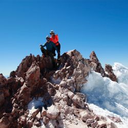
Mount Shasta is a beautiful site when you approach it and, even more, when you get to the visitor's parking lot. It always has snow on its peak and 4 of the largest glaciers in California. Mt. Shasta is a popular climb for both intermediate and experienced mountaineers. Although strenuous, this non-technical climb is suitable for people in good physical condition who are comfortable with climbing at elevations above 10,000 feet. I thought it wasn't as hard to climb as I expected, though you do have to watch your footing. The peak of Mt. Shasta is 14,180 feet is the 2nd highest peak in the Cascades and the 5th highest in California. Mt. Shasta is a potentially active stratovolcano. It erupts every 600 to 800 years, though, volcanoes don't care about averages. Stratovolcanoes are steep with periodic, explosive eruptions. The lava that flows from them is highly viscous, and cools and hardens before spreading very far. Mt. St. Helen's and Mt. Rainer are also stratovolcanoes...and we know how explosive Mt. St. Helen's was! I can say I climbed Mt. Shasta. It was only a few hundred feet but Shhhh... we don't have to mention that part! read more


I believe some of the best ways to capture Mount Shasta's alluring grand stature is by simply pulling off the side of the road and taking pictures. It can be that easy. But, if you'd like a more in depth understanding, please take a moment to read this review, lol. I was driving Interstate 5 - South from Oregon and it's incredible how iconic Mount Shasta stands in the background, so high and mighty above the flat surrounding terrain. I believe even if you're navigating I-5 North from Redding, it will also afford you worthwhile instances to stop for panoramic moments. I regret not taking time to exit my car and see the sights. Maybe I just got lazy, but I was convinced I could receive better looks the closer I made my way towards the mountain. And in fact, this was my 2nd visit to Mount Shasta. I had previously attempted to explore it, but due to ferocious wildfires in the area, the road leading from town up the mountain was barriered off. So, although I think you can take really good photos of Mount Shasta from I-5 North or South (especially when the sun is behind you), I'd like to relay how to possibly better come face-to-face with this famous Northern California landmark. You can use Google Maps and just plug "Mount Shasta" into the search column. At the very least, you'll be guided into the relatively quiet town of Mt. Shasta, CA, on the outskirts of the mountain. A quick note...Mount Shasta town offers restaurants, gas stations, lodging, and a small Visitor Center good for brochures and information leading to scenic destinations throughout the region. Once here at Mount Shasta, California, there's a paved 14-mile road called the Everitt Memorial Highway (A-10) taking you to the highest point you can drive. According to Google, to find this road..."take exit 738, turn right onto Lake Street and right again onto Everitt Memorial Highway". This 14-mile drive winds and twists up the mountainside. Along the way, there weren't frequent opportunities to stop and view Mount Shasta's statuesque peak. After each turn higher and higher, I kept anticipating this magnificent natural wonder to just blossom out of nowhere, like a page out of the Mount Rainier drive in Washington state (if anyone has ever been there). But, the pull-offs along the 14-mile road were really limited. At Mile 7, there's a roadside marker for John Everitt Vista Point. Yet, there was nothing to see at this overlook. And, I was confused where the observation point even began. This stop was in the thick of the woods. I thought maybe you had to do some hiking to reach the vista point, but there were no signs. Next stop was the Bunny Flat Trail. I didn't find any details about the length and difficulty of the pathway, but, I started hiking at my own pace and did some improvising. My main goal was just to witness Mount Shasta from all angles. This Bunny Flat Trail was alright, and at least the sun reflected well on Shasta's mountainside for the afternoon time. Finally at the end of the drive, you arrive at the Old Ski Bowl Trail. This appeared to be the primary activity hike at Mount Shasta. It goes for 4 miles each way with an elevation gain of 1800 feet. Standing at the trailhead, it stated that there's a $25 fee required to climb Mount Shasta. I was perplexed by this. Does that mean it's $25 to physically mountain climb or scramble up to the top? Or, is it $25 for each person hiking at the Old Ski Bowl Trail? I was torn about what to do because...the views of Mount Shasta beside the parking lot appeared ordinary. The landscape was barren with rugged alpine terrain, sort of like walking among a brittle volcanic landscape. I was debating whether to just skip the hike and drive back down the mountainside. Plus, here at the Old Ski Bowl, Shasta's peak was completely hidden. In all actuality, I could have wandered aimlessly. But, I just sensed you probably had to hike a good portion of the 4 miles to be rewarded with a picturesque setting. It was in this moment when I realized I would have been better served just stopping along I-5 for grabbing long range photos of Mount Shasta in the distance. I did hike a portion of the Old Ski Bowl Trail but never made significant strides towards getting up close to the summit. And for early October, Shasta didn't have that classic snowcapped peak which lends itself to dramatic picture taking. Driving back down towards town had me feeling a bit puzzled. Being here for a 2nd time, I never felt connected to Mount Shasta. I wondered, in the end, what is still the most efficient way to get a satisfactory encounter? Hey, who know, maybe 3rd time will be a charm in the future? Ultimately, my general advice for visiting would be...take pictures whenever possible while driving I-5, and temper your expectations for the scenery on the 14-mile Everitt Memorial Highway drive. read more


Came here in February this year! Lots and lots of snow so be sure to snow chain up, get a four-wheel drive, and load up the sandbags if you're coming up for snow activities. It was very pretty overall as the views were immaculate as you got a scope of the city, there were many folks snowmobiling, skiing, and just walking around! If you're up for it, trekking Shasta herself is also great! The water from Headwaters spring in the country park not far from the mountain itself is also a must-try! read more

I have to say I was quite impressed with this mountain sitting at 14,000 plus feet above see level. The farthest I could get up by vehicle was the "Bunny Flat Trailhead." I wanted to go a little farther up the Panther Meadow's Campground, but the road was still closed. It was not a big deal because from where I was at, the view of the mountain was great, and there were a number of easy trails to check things out. I did not take to main trail up the mountain because I was not prepared for such and adventure, but I ventured on the trails neat base and relaxed at view points to soak it all in. read more

Traveling up A10, and reaching the end of the road leads to countless cars and people camping. From there, you start your trek into the mountain. This year 2018, the snow was still present and basically, you walk on snow. In the summer months, there is no snow until you go further in. This mountain is the crown jewel of the Cascade mountains, and it is said to be a sleeping volcano. It is energetically strong and magical. Visited by skiers and mystics alike, this is a beautiful place to be. read more


7 years ago
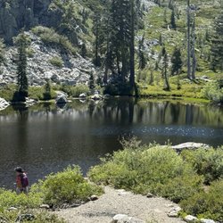
I have been visiting Mt. Shasta for many years and each time brings a completely different experience. The road up to the mountain goes all the way to the upper parking lot that many years may only be open for a few short months weather dependent. End of August is usually a safe bet having gone there on June 21 one year and had to turn back due to snow fall. The mountain has its own mind set when it comes to weather. During the spring and early spring and summer there is beautiful hikes in meadows full of wild flowers and small meandering streams. Just to see the view of the mountain is worth the visit. Best to get the park service guide to know what paths are available and recommended skill sets to navigate. During the summer there is usually a resident park host that has amazing stories and information to share. Yes they may include alien sightings and other mystical things people have experienced. Have been there for new moon and full moon each with its own awe. When visiting at night you can become so aware of the stillness the area has to offer. Good to remember to bring water and snacks as the altitude will tend to dehydrate. For my visit I do my stop at Berryville market for snacks. read more


More info about Mount Shasta
Mount Shasta, CA 96067
Directions
Visit Website
https://en.wikipedia.org/wiki/Mount_Shasta
Hours
Outdoor Amenities
Ask the Community - Mount Shasta
Review Highlights - Mount Shasta


Mount Shasta - climbing - Updated July 2026
Best of Mount Shasta
People found Mount Shasta by searching for…
Lakes in Mount Shasta, California
Snow Play in Mount Shasta, California
Parks in Mount Shasta, California
View Points in Mount Shasta, California
Rock Climbing in Mount Shasta, California
Swimming Lakes in Mount Shasta, California
Fishing Spots in Mount Shasta, California
Places to Take Pictures in Mount Shasta, California
Hiking Trails in Mount Shasta, California
Scenic Drive in Mount Shasta, California
Visitor Centers in Mount Shasta, California
Parks for Kids in Mount Shasta, California
Gyms in Mount Shasta, California
Off Road Trails in Mount Shasta, California
Tourist Attractions in Mount Shasta, California
Redwood Trees in Mount Shasta, California
Gold Panning in Mount Shasta, California
Sunset View in Mount Shasta, California
Sunrise View in Mount Shasta, California
Climbing Gym in Mount Shasta, California
Attractions in Mount Shasta, California
To Do in Mount Shasta, California
Trending Searches in Mount Shasta, CA
Browse Articles
Browse Brands
Related Searches in Mount Shasta, CA
Affordable Jet Ski Rental Options in Mount Shasta, California
Affordable Kayak Rental Services in Mount Shasta, California
Best Fishing Locations and Guides in Mount Shasta, California
Best Fun Things to Do in Mount Shasta, California
Best Gym With Sauna Amenities in Mount Shasta, California
Best Gyms With Swimming Pools in Mount Shasta, California
Best Off Leash Dog Parks in Mount Shasta, California
Best Places for Exercise and Fitness in Mount Shasta, California
Best Places for Horseback Riding in Mount Shasta, California
Best Spots for Star Gazing in Mount Shasta, California
Best Waterfalls and Swimming Holes in Mount Shasta, California
Check Out Off Road Trails in Mount Shasta, California
Discover Dog Friendly Beaches Near Mount Shasta, California
Discover Dog Friendly Trails to Explore in Mount Shasta, California
Discover Fun Activities to Do in Mount Shasta, California
Discover Fun Kid Activities to Enjoy in Mount Shasta, California
Discover Great Fitness Classes Available in Mount Shasta, California
Discover Kids Yoga Classes Near Mount Shasta, California
Discover Outdoor Gym Facilities in Mount Shasta, California
Discover Scenic Waterfall Spots in Mount Shasta, California
Discover Top Yoga Options and Studios in Mount Shasta, California
Discover a Hiking Trail in Mount Shasta, California
Discover the Best Night Hike Trails in Mount Shasta, California
Enjoy Camping Adventures Around Mount Shasta, California
Enjoy Exciting Mountain Biking Adventures in Mount Shasta, California
Enjoy Hiking Adventures in Mount Shasta, California
Enjoy Indoor Lap Pool Facilities in Mount Shasta, California
Enjoy Kayaking Adventures in Mount Shasta, California
Enjoy Tent Camping Spots Around Mount Shasta, California
Enjoy the Best Bouldering Experiences in Mount Shasta, California
Enjoy the Best Tubing Experiences in Mount Shasta, California
Explore Beautiful Parks and Green Spaces in Mount Shasta, California
Explore Easy Hikes Perfect for All in Mount Shasta, California
Explore Fitness Centers and Gyms in Mount Shasta, California
Explore Fun Activities to Do in Mount Shasta, California
Explore High End Gyms Available in Mount Shasta, California
Explore Martial Arts Options in Mount Shasta, California
Explore Nature Spots Around Mount Shasta, California
Explore Popular Campgrounds Near Mount Shasta, California
Explore Popular RV Parks Around Mount Shasta, California
Explore Popular View Points Around Mount Shasta, California
Explore Scenic Lakes to Visit in Mount Shasta, California
Explore Summer Camps for All Ages in Mount Shasta, California
Explore Top Gyms in Mount Shasta, California Now
Explore Top Water Parks in Mount Shasta, California Today
Explore Top Womens Gym Options in Mount Shasta, California Today
Explore Volleyball Courts Available in Mount Shasta, California
Explore the Best Beach Spots in Mount Shasta, California
Explore the Best Boating Spots in Mount Shasta, California
Explore the Best Rock Climbing Areas in Mount Shasta, California