Pacific Crest Trail, Squaw Valley Trailhead Photos


More like Pacific Crest Trail, Squaw Valley Trailhead
Recommended Reviews - Pacific Crest Trail, Squaw Valley Trailhead
Start your review...

7 years ago
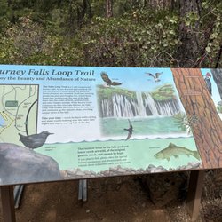
Anyone hear of the Pacific Crest Trail (PCT) before? This trail is approximately 2650 miles long, and it stretches from the Mexican border in Southern California all the way up to the Canadian border in Washington state. For the folks who are able to complete the trek, it normally takes them about 5 months. Unfortunately, my lovely wife and I have not gotten the chance to do this hike of a lifetime. We have hiked a miniscule portion of the incredible Pacific Crest Trail, though. We have also met a couple of hikers who were in the midst of completing the dream! This trailhead is one of the areas where you can access the PCT. It is pretty darn cool. read more


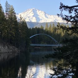
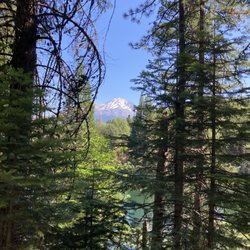
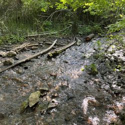
This trailhead is gorgeous!. Someday I will hike this section. For now it's beautiful to drive there & hang out by the creek, look at the bridges, scenery and those tropical-looking umbrella plants . I was hoping to talk to some hikers passing through but we weren't there long enough. To get there you take the road (Squaw Valley Rd. I believe) from McCloud, the one that heads to the McCloud Reservoir. Once you pass Friday's RV Retreat, take the first road to the right and drive in a couple miles (apr). The trailhead will be on your left. You'll see a toilet...If you want better directions you can also stop at the Ranger's office in McCloud. read more


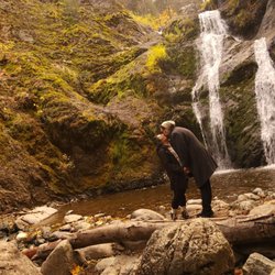
16 years ago
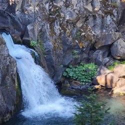
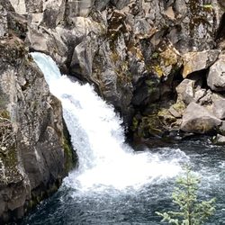
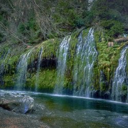
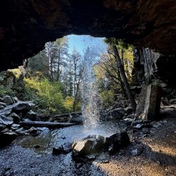
Why Go? * You like to hear/see running water * You like hike under trees * You like to think you are hiking in the middle of a scene from the movie Twilight Trail Descrip * Lush, follows the creek, good views above as well as can get closer to the creek * Some parts of the trail a bit narrow * Supposedly there are 2 waterfalls around 2.5 or 3 miles I think * Note - when went in July 2010 there was a sign that was posted that at around 2.5 miles i think the trail was washed out and there is no way around Things to Keep in Mind: * The last couple miles to get to the trailhead is unpaved rocky road so make sure your car can handle it * The way there we drove real real slow (we had a jeep) and we could feel every freakin' bump..on the way back decided to drive faster and it was fine Resources: * http://www.trails.com/tcatalog_trail.aspx?trailid=MGS046-003 * http://fs.usda.gov/wps/portal/fsinternet/!ut/p/c4/04_SB8K8xLLM9MSSzPy8xBz9CP0os3gDfxMDT8MwRydLA1cj72BTJw8jAwjQL8h2VAQAzHJMsQ!!/?ss=110514&navtype=BROWSEBYSUBJECT&navid=110340000000000&pnavid=110000000000000&recid=6590&actid=64&ttype=recarea&pname=Shasta-Trinity%20National%20Forest%20-%20Squaw%20Valley%20Creek%20Trail read more

More info about Pacific Crest Trail, Squaw Valley Trailhead
McCloud, CA 96057
Directions
Hours
Outdoor Amenities


Why does Yelp recommend reviews?
1 review that is not currently recommended
The reviews below are not factored into the business's overall star rating.
8 years ago
Pacific Crest Trail, Squaw Valley Trailhead - localflavor - Updated May 2026
Best of McCloud
People found Pacific Crest Trail, Squaw Valley Trailhead by searching for…
Hiking Trails With Waterfalls in McCloud, CA
Off Road Trails in McCloud, CA
Hiking With Kids in McCloud, CA
Beautiful Views in McCloud, CA
Waterfalls and Swimming Holes in McCloud, CA
Arts & Entertainment in McCloud, CA
Off Leash Dog Hikes in McCloud, CA
Scenic Night View in McCloud, CA
Dog Friendly Things to Do in McCloud, CA
Trending Searches in McCloud, CA
Boat Rental near Pacific Crest Trail, Squaw Valley Trailhead
Botanical Gardens near Pacific Crest Trail, Squaw Valley Trailhead
Campgrounds near Pacific Crest Trail, Squaw Valley Trailhead
Flower Shop near Pacific Crest Trail, Squaw Valley Trailhead
Hair near Pacific Crest Trail, Squaw Valley Trailhead
Nurseries & Gardening near Pacific Crest Trail, Squaw Valley Trailhead
Parks near Pacific Crest Trail, Squaw Valley Trailhead
Party Equipment Rentals near Pacific Crest Trail, Squaw Valley Trailhead
Pedicure near Pacific Crest Trail, Squaw Valley Trailhead
Picnic Areas near Pacific Crest Trail, Squaw Valley Trailhead
Places To Take Pictures near Pacific Crest Trail, Squaw Valley Trailhead
Running Trails near Pacific Crest Trail, Squaw Valley Trailhead
Rv Rental near Pacific Crest Trail, Squaw Valley Trailhead
Scenic Drive near Pacific Crest Trail, Squaw Valley Trailhead
Secret Spots near Pacific Crest Trail, Squaw Valley Trailhead
Swimming Holes near Pacific Crest Trail, Squaw Valley Trailhead
Watch Sunset near Pacific Crest Trail, Squaw Valley Trailhead
Browse Articles
Browse Nearby
BEST of McCloud, California Things to Do near Pacific Crest Trail, Squaw Valley Trailhead
BEST of McCloud, California Restaurants near Pacific Crest Trail, Squaw Valley Trailhead
BEST of McCloud, California Shopping near Pacific Crest Trail, Squaw Valley Trailhead
BEST of McCloud, California Coffee near Pacific Crest Trail, Squaw Valley Trailhead
BEST of McCloud, California Hotels near Pacific Crest Trail, Squaw Valley Trailhead
BEST of McCloud, California Breakfast near Pacific Crest Trail, Squaw Valley Trailhead
BEST of McCloud, California Campgrounds near Pacific Crest Trail, Squaw Valley Trailhead
BEST of McCloud, California Lodging near Pacific Crest Trail, Squaw Valley Trailhead
BEST of McCloud, California Photo Spots near Pacific Crest Trail, Squaw Valley Trailhead
Browse Brands
Related Searches in McCloud, CA
Affordable Jet Ski Rental Options in McCloud, California
Affordable Kayak Rental Services in McCloud, California
Best Fishing Locations and Guides in McCloud, California
Best Places for Horseback Riding in McCloud, California
Best Waterfalls and Swimming Holes in McCloud, California
Check Out Off Road Trails in McCloud, California
Discover Dog Friendly Beaches Near McCloud, California
Discover Scenic Waterfall Spots in McCloud, California
Discover a Hiking Trail in McCloud, California
Discover the Best Night Hike Trails in McCloud, California
Enjoy Camping Adventures Around McCloud, California
Enjoy Exciting Mountain Biking Adventures in McCloud, California
Enjoy Kayaking Adventures in McCloud, California
Enjoy Tent Camping Spots Around McCloud, California
Enjoy the Best Tubing Experiences in McCloud, California
Enjoy the Best Walking Trails in McCloud, California
Explore Beautiful Parks and Green Spaces in McCloud, California
Explore Easy Hikes Perfect for All in McCloud, California
Explore Fun Activities to Do in McCloud, California
Explore Nature Spots Around McCloud, California
Explore Popular Campgrounds Near McCloud, California
Explore Popular RV Parks Around McCloud, California
Explore Popular View Points Around McCloud, California
Explore Scenic Lakes to Visit in McCloud, California
Explore Secret Spots Worth Visiting in McCloud, California
Explore the Best Beach Spots in McCloud, California
Explore the Best Boating Spots in McCloud, California
Explore the Best Swimming Holes Around McCloud, California
Family Friendly Hiking With Kids in McCloud, California
Find Cozy Camping Cabins in McCloud, California
Find the Best Playgrounds to Visit in McCloud, California
Hiking Trails With Waterfalls in McCloud, California
Must-See Tourist Attractions Around McCloud, California
Off Leash Dog Hiking Trails in McCloud, California
Perfect Spots to Watch Sunset in McCloud, California
Plan a Scenic Drive Route Near McCloud, California
Popular Outdoor Activities to Try in McCloud, California
Popular Places to Take Pictures in McCloud, California
Popular Things to Do in McCloud, California
Popular Things to See in McCloud, California
Relax at Natural Hot Springs Near McCloud, California
Safe and Fun Parks for Kids in McCloud, California
Top Paddleboarding Activities in McCloud, California
Top Playgrounds for Kids to Enjoy in McCloud, California
Top Running Trails to Explore in McCloud, California
Top Swimming Lakes to Enjoy in McCloud, California
Top Swimming Spots and Pools in McCloud, California
Top Things to Do With Kids in McCloud, California