Mossbrae Falls - Access Restricted Photos


More like Mossbrae Falls - Access Restricted
Recommended Reviews - Mossbrae Falls - Access Restricted
Start your review...

Reviews With Photos - Mossbrae Falls - Access Restricted


Lots of walking is required but the view is worth it. Gotta park somewhere close to shasta resort then walk down to the residential area... cross the bridge then veer to your left and just follow the railroad track until you reach the bridge. No need to cross bec on your right side is a spectacular gift from Up above :-) extra caution if though bec this is a private property & stay away from passing train

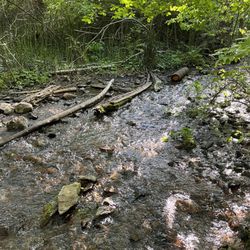
This review is for the Hedge Creek Falls to Mossbrae Falls which was a ~1.7 mile round trip that took ~50 mins to complete. Hedge Creek Falls was interesting to walk behind! Followed by crossing the Sacramento river and reaching the unique Mossbrae Falls! The river was mid-calf to knee high and the rocks were slippery so be careful when crossing! Disclaimer: Cross the river at your own risk (pay attention to the water current, etc). Limited parking spots on dirt road across Hedge Creek Falls trailhead. Short video of the hike for those interested: https://youtu.be/-5EGdyT14dw

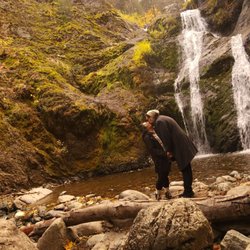
Stunning, stunning, STUNNING! Everything that I could have imagined and more. The pictures don't do this waterfall any justice honestly. This is one where you've got to be there to experience it for yourself. Believe it or not, this visit to Mossbrae Falls has been on my bucket list for years. I can't even remember when I first found out about this waterfall. It was definitely during my pre-Yelp days, but I've always wanted to see it. I've had a few opportunities in the past to check it out, but the thought of trespassing through private property and walking next to an active train to get there was what deterred me for so long. Welp, that all changed this past summer. I finally made it there. And it was completely worth it on all levels. The main trail that runs alongside the train tracks and passes through private property is the most popular and also the easiest way to get to the falls. It's about a 3 mile hike/walk roundtrip. It can be dangerous since you're essentially walking right next to an active train track. However, if you're keeping an eye out, you'll be fine. Don't be stupid and walk directly on the tracks. It sounds like common sense, but I saw more than a handful of people doing this. Stopping in the middle of the tracks to get a selfie. Even laying on the tracks. Some people just never learn. This is probably why the trail is listed at "access restricted". It's a straight shot to the falls when you take the main trail this way. But, there's also a shortcut that can be taken from Hedge Creek Falls. I wasn't planning on taking the shortcut at first. I was just going to hike both falls. But after realizing how close I was to Mossbrae Falls and learning that I could skip most of the hike next to the train tracks, I decided to do it. The catch is, you have to cross the Sacramento River to get to the other side. Sounds easy enough, right? Wrong. This is not an easy river crossing. First off, the rocks are extremely jagged and slippery making for a terribly painful and scary experience for bare feet. Secondly, the water is ice cold. I did this hike in the summertime and my feet still went numb. Thirdly, the river gets past waist deep when you reach the middle which makes it even harder to navigate. I'm gonna be honest, I wasn't prepared for this at all. It was an impromptu decision that I made once I saw how close Mossbrae Falls was. But once I made it halfway across, I was already regretting my decision. I think if I had worn water shoes and maybe had a hiking stick to help me balance, it wouldn't have been so painful. Every single person crossing the river slipped on those rocks multiple times. I think 2 or 3 people even ended up falling in. I'm not trying to scare anyone from doing it, but I'd just make sure to be prepared. It looks super easy when you're glancing at it, but once you get in, it's an entire different story. But anywaaaays! After you cross the river, it's about a half mile or so until you reach the falls. You'll see a steel bridge and then make an immediate right through the trees down the trail. And then BOOM!! Just pure beauty right before your eyes. These falls remind me of something that you'd find in Hawaii. Water gushing down through the beautiful green leaves. It's truly amazing. It wasn't flourishing during the summer, but it was still pouring down. Such a heavenly sight. From here, you can actually get in and take a dip or get cozy on the rocks and have a little picnic. It does seem to be a popular spot but not too crowded at all. With how hot it gets down there, I'm sure it feels amazing to get in that water. So yes, there's some riskiness involved to get there. A lot of riskiness actually. However, the experience 100% warrants that risk. I personally wouldn't take the shortcut from Hedge Creek Falls again. Next time, I'll just take the longer route through the train track. And yes I said next time because I am absolutely coming back to see those falls again. Would highly recommend it. It's pretty damn magical.


I'm a sucker for railroad hikes so when I saw this, I had to do it! This is an active track so stay alert! You walk along the railroad and once you see the bridge, you make a right down the hill to see the falls. The falls is breathtaking! One of my favorite waterfalls I've ever seen - you're literally surrounded by the falls. It's an easy 3 mile out and back. If you walk past the bridge, you'll walk along the tracks for awhile and see small waterfalls along the tracks.

Don't want to miss about a mile and half one way. I am sure there are many ways to get here but why not make it an adventure and take the railroad tracks more than likely you will get the train but it was fun not as scary as it seems.. just stay on the side of the river.. plan accordingly take some water toilet paper if you need to pop a squat. There is not bathrooms. But the water fall was beautiful.. take a lunch and have a picnic..

This place is breathe taking! Came here around 11am on a Saturday. The entrance isn't too hard to find, entrance is on the right side of N. Dunsmuir Ave street is Scarlet Way. You pretty much park on Dunsmuir and then walk to the Shasta Retreat and walk down the pathway. You stay right at Cave ave then you will pass a bridge and go right at the train tracks. It is access restricted since you have to walk on the side of train tracks for 30 mins each way but totally worth it. The rocks didn't bother us at all and the train only passed by once on our way back. You will start hearing the falls and before you hit the bridge they will be on the right side down a little trail that's very noticeable. If you have time take some lunch and enjoy this hidden gem.

This place is so magical in person, pictures don't do justice! I'm so glad I went, I was super hesitant to go at first given it is trespassing, scared of getting hit by the train, confusing instructions, etc. But we did it, it wasn't hard to find at all, and I would go back again! We went on a Sunday morning around 930AM and there were plenty of parking on the north side of Dunsmuir Ave. Don't drive into the Shasta Retreat, there is no public parking. Park on the street off Dunsmuir Ave near some old closed down shop and a hotel/motel then walk towards Shasta retreat. Keep going down, veer right, and go straight past the homes until you hit a bridge that takes you to the railroad tracks. Cross the bridge and turn right, keep to the right side of the railroad tracks and walk along the river. Make sure you stay to the right side of the tracks because there is more space to walk on and move aside if the train comes by. It is an active track, we encountered the trains twice during our round trip hike and it took a few minutes for the trains to pass by. You can easily hear the trains coming by the tracks vibrating/high pitch? Can't describe it but it's very audible. The path is rocky with big, sometimes pointy rocks, so make sure you wear thick shoes or hiking boots... and make sure your dogs have boots on or carry them. We carried our 10lb chihuahua/min pinscher the whole time. He was frightened by the trains as it was a bit loud, but it was quite exhilarating see trains up close. The walk takes about 25-30 min along the tracks until you hit a bridge, don't cross it and instead look for a path to your right. There'll be rocks pointing towards the falls. Once you walk down a short path to the falls, you'll be stunned by the beauty and fairy tale grandeur of the falls. The fall is quite wide and hard to fit in a picture and the sounds were so relaxing. It was cold, our dog was shivering the entire time and felt uncomfortable, hehe. So beautiful, for 5 minutes we had the entire falls to ourselves, then a couple girls appeared and it was just us 4 for a good 20 minutes. I didn't want to leave but we left as soon as another large group came down. We went at a good time (930am on Sunday) when the hike to the falls were almost empty; we saw only one other girl hiking towards the falls and a couple walking back in the opposite direction. When we left the falls it was close to 1030am, we saw about 5 other groups walking towards the falls on our way back... so if you want seclusion, try coming on a weekday or early morning! At first I was a bit scared being the only ones hiking but felt comfortable when we saw a coupe walking back.

Mossbrae Falls is breathtakingly beautiful. From Santa Rosa, it is a 4 hr and 20 mins drive up north to Dunsmuir, CA. I went on 12/23/2017 two days before Christmas during the holidays and there were no crowds and barely anybody. It was a nice quiet hike on the restricted train tracks and once we arrived, there were two other people there taking photos. They left shortly after and we had the whole waterfalls to ourselves. It was so peaceful taking in nature and being alone definitely helped intensify the experience. I'm giving credit to oregonblogger.com as I followed his instructions and led me there with no problems. Per oregonblogger.com: (TRESPASS AT YOUR OWN RISK) The entrance in where you will start off is on the corner of Scarlet Way/N Dunsmuir Ave. Here are the coordinates 41°13'42.4"N 122°16'33.3"W If you can't pinpoint these roads then type in this address ( 4727 Dunsmuir Ave, Dunsmuir, CA 96025 ) It's a motel called Cave Springs about a block away from the entrance. Here is what the entrance looks like. Make sure you park on the side of the road. You are not allowed to park inside the Shasta Retreat. You will walk down past the entrance. The road will fork when you make it to the bottom. Make sure you take a right onto Cave Ave. Then you will come upon a bridge and right after the bridge are the train tracks. Take a right on the tracks. The tracks will take you to the waterfall. It's about a 30 minute walk. Make sure you are walking without headphones. The tracks are active. I was there on the weekend and I didn't see any trains. I would recommend walking on the right since there is more room in case a train comes by. You can start hearing the falls about 200 feet away. The falls are about 50 feet before the bridge on the right. You won't miss it.

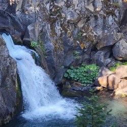
Mossbrae falls is really as close to magical as you can get. The water cascading down isn't very heavy, but the span of the waterfall is quite long. The waterfall is in a secluded area with a lot of tree coverage and feels very peaceful. Because there is so much tree coverage, the temperature by the falls is a lot cooler. I went in late September (when it was about 75 degrees), and it felt about 65 degrees standing by the falls. Technically, I think this hike is illegal because you're on private property, but it's not as ominous as it sounds--I definitely passed other people on the hike. You can walk right up to the water and swim, but I would recommend going between June and August if you plan on going in the water. The hike to the falls is very relaxing, and while there are other people on the trail, it isn't extremely trafficked. The hike is very flat and short, but you do have to walk on loose rock the entire time that is right next to a railroad track. This actually gets pretty tiring after awhile and slows you down. I walked on the concrete support blocks on the actual railroad track. This was a lot easier on my feet and made my trip a lot quicker. It's more dangerous to walk on the actual track, so if you're worried then I would just walk on the rocks. However, it was pretty easy to hear if a train was coming.

Technically it is private property so go at your own risk. Do not park inside Shasta retreat. I recommend to park down the streets, South on Dunsmuir near the burger and ice cream joint. Go with good hiking boots because the rocks on the railroad can be hard on your foot. I do not recommend bringing dogs; the rocks can tear their paw pads. Always walk on the side nearest to the river. And as always, respect the property, do not litter/vandalize, stay safe and you'll be fine. It's not very scenic on the way there but you'll be completely satisfied when you get the waterfall. We fell in love with it; peaceful, serene, and majestic. We got some good pictures, relaxed a bit, and soaked in the views. Then headed back and got shakes and ice cream. 5/5 would totally visit again!

The water is hypothermia inducingly cold, the walk is treacherous and the falls aren't that exciting. You can take the long route which requires a lot more walking near the train tracks or attempt the river crossing which could end with you swept miles downriver or drowned. At any moment they could let water out of the down to send a surge down the Sacramento River and send you off through rocks and rapids below the falls. The trains come through fast and around blind corners and the roar of the river masks the sound of the train. It is a dangerous hike and people have died there. I don't recommend it for day trippers or casual tourists. Advanced hiking skills required and extra attention to safety and strong swimmers only. Even in mid August the water is high and freezing and the river crossing is very slippery and dangerous. If you know what you are doing and manage the trek there and back you will have seen one of the areas smaller but pretty waterfalls. There is talk of building a trail with a pedestrian bridge to the falls so once that is done it will likely be overrun with day trippers. I recommend going now but be careful. read more


7 months ago
1 year ago
Lots of walking is required but the view is worth it. Gotta park somewhere close to shasta resort then walk down to the residential area... cross the bridge then veer to your left and just follow the railroad track until you reach the bridge. No need to cross bec on your right side is a spectacular gift from Up above :-) extra caution if though bec this is a private property & stay away from passing train read more


This review is for the Hedge Creek Falls to Mossbrae Falls which was a ~1.7 mile round trip that took ~50 mins to complete. Hedge Creek Falls was interesting to walk behind! Followed by crossing the Sacramento river and reaching the unique Mossbrae Falls! The river was mid-calf to knee high and the rocks were slippery so be careful when crossing! Disclaimer: Cross the river at your own risk (pay attention to the water current, etc). Limited parking spots on dirt road across Hedge Creek Falls trailhead. Short video of the hike for those interested: https://youtu.be/-5EGdyT14dw read more


7 months ago
Stunning, stunning, STUNNING! Everything that I could have imagined and more. The pictures don't do this waterfall any justice honestly. This is one where you've got to be there to experience it for yourself. Believe it or not, this visit to Mossbrae Falls has been on my bucket list for years. I can't even remember when I first found out about this waterfall. It was definitely during my pre-Yelp days, but I've always wanted to see it. I've had a few opportunities in the past to check it out, but the thought of trespassing through private property and walking next to an active train to get there was what deterred me for so long. Welp, that all changed this past summer. I finally made it there. And it was completely worth it on all levels. The main trail that runs alongside the train tracks and passes through private property is the most popular and also the easiest way to get to the falls. It's about a 3 mile hike/walk roundtrip. It can be dangerous since you're essentially walking right next to an active train track. However, if you're keeping an eye out, you'll be fine. Don't be stupid and walk directly on the tracks. It sounds like common sense, but I saw more than a handful of people doing this. Stopping in the middle of the tracks to get a selfie. Even laying on the tracks. Some people just never learn. This is probably why the trail is listed at "access restricted". It's a straight shot to the falls when you take the main trail this way. But, there's also a shortcut that can be taken from Hedge Creek Falls. I wasn't planning on taking the shortcut at first. I was just going to hike both falls. But after realizing how close I was to Mossbrae Falls and learning that I could skip most of the hike next to the train tracks, I decided to do it. The catch is, you have to cross the Sacramento River to get to the other side. Sounds easy enough, right? Wrong. This is not an easy river crossing. First off, the rocks are extremely jagged and slippery making for a terribly painful and scary experience for bare feet. Secondly, the water is ice cold. I did this hike in the summertime and my feet still went numb. Thirdly, the river gets past waist deep when you reach the middle which makes it even harder to navigate. I'm gonna be honest, I wasn't prepared for this at all. It was an impromptu decision that I made once I saw how close Mossbrae Falls was. But once I made it halfway across, I was already regretting my decision. I think if I had worn water shoes and maybe had a hiking stick to help me balance, it wouldn't have been so painful. Every single person crossing the river slipped on those rocks multiple times. I think 2 or 3 people even ended up falling in. I'm not trying to scare anyone from doing it, but I'd just make sure to be prepared. It looks super easy when you're glancing at it, but once you get in, it's an entire different story. But anywaaaays! After you cross the river, it's about a half mile or so until you reach the falls. You'll see a steel bridge and then make an immediate right through the trees down the trail. And then BOOM!! Just pure beauty right before your eyes. These falls remind me of something that you'd find in Hawaii. Water gushing down through the beautiful green leaves. It's truly amazing. It wasn't flourishing during the summer, but it was still pouring down. Such a heavenly sight. From here, you can actually get in and take a dip or get cozy on the rocks and have a little picnic. It does seem to be a popular spot but not too crowded at all. With how hot it gets down there, I'm sure it feels amazing to get in that water. So yes, there's some riskiness involved to get there. A lot of riskiness actually. However, the experience 100% warrants that risk. I personally wouldn't take the shortcut from Hedge Creek Falls again. Next time, I'll just take the longer route through the train track. And yes I said next time because I am absolutely coming back to see those falls again. Would highly recommend it. It's pretty damn magical. read more


2 years ago
Beautiful place wonderful energy . I always feel better when I leave after I go for a swim in the healing waters . read more


I'm a sucker for railroad hikes so when I saw this, I had to do it! This is an active track so stay alert! You walk along the railroad and once you see the bridge, you make a right down the hill to see the falls. The falls is breathtaking! One of my favorite waterfalls I've ever seen - you're literally surrounded by the falls. It's an easy 3 mile out and back. If you walk past the bridge, you'll walk along the tracks for awhile and see small waterfalls along the tracks. read more


Don't want to miss about a mile and half one way. I am sure there are many ways to get here but why not make it an adventure and take the railroad tracks more than likely you will get the train but it was fun not as scary as it seems.. just stay on the side of the river.. plan accordingly take some water toilet paper if you need to pop a squat. There is not bathrooms. But the water fall was beautiful.. take a lunch and have a picnic.. read more


This place is breathe taking! Came here around 11am on a Saturday. The entrance isn't too hard to find, entrance is on the right side of N. Dunsmuir Ave street is Scarlet Way. You pretty much park on Dunsmuir and then walk to the Shasta Retreat and walk down the pathway. You stay right at Cave ave then you will pass a bridge and go right at the train tracks. It is access restricted since you have to walk on the side of train tracks for 30 mins each way but totally worth it. The rocks didn't bother us at all and the train only passed by once on our way back. You will start hearing the falls and before you hit the bridge they will be on the right side down a little trail that's very noticeable. If you have time take some lunch and enjoy this hidden gem. read more


2 years ago
This place is so magical in person, pictures don't do justice! I'm so glad I went, I was super hesitant to go at first given it is trespassing, scared of getting hit by the train, confusing instructions, etc. But we did it, it wasn't hard to find at all, and I would go back again! We went on a Sunday morning around 930AM and there were plenty of parking on the north side of Dunsmuir Ave. Don't drive into the Shasta Retreat, there is no public parking. Park on the street off Dunsmuir Ave near some old closed down shop and a hotel/motel then walk towards Shasta retreat. Keep going down, veer right, and go straight past the homes until you hit a bridge that takes you to the railroad tracks. Cross the bridge and turn right, keep to the right side of the railroad tracks and walk along the river. Make sure you stay to the right side of the tracks because there is more space to walk on and move aside if the train comes by. It is an active track, we encountered the trains twice during our round trip hike and it took a few minutes for the trains to pass by. You can easily hear the trains coming by the tracks vibrating/high pitch? Can't describe it but it's very audible. The path is rocky with big, sometimes pointy rocks, so make sure you wear thick shoes or hiking boots... and make sure your dogs have boots on or carry them. We carried our 10lb chihuahua/min pinscher the whole time. He was frightened by the trains as it was a bit loud, but it was quite exhilarating see trains up close. The walk takes about 25-30 min along the tracks until you hit a bridge, don't cross it and instead look for a path to your right. There'll be rocks pointing towards the falls. Once you walk down a short path to the falls, you'll be stunned by the beauty and fairy tale grandeur of the falls. The fall is quite wide and hard to fit in a picture and the sounds were so relaxing. It was cold, our dog was shivering the entire time and felt uncomfortable, hehe. So beautiful, for 5 minutes we had the entire falls to ourselves, then a couple girls appeared and it was just us 4 for a good 20 minutes. I didn't want to leave but we left as soon as another large group came down. We went at a good time (930am on Sunday) when the hike to the falls were almost empty; we saw only one other girl hiking towards the falls and a couple walking back in the opposite direction. When we left the falls it was close to 1030am, we saw about 5 other groups walking towards the falls on our way back... so if you want seclusion, try coming on a weekday or early morning! At first I was a bit scared being the only ones hiking but felt comfortable when we saw a coupe walking back. read more


Mossbrae Falls is breathtakingly beautiful. From Santa Rosa, it is a 4 hr and 20 mins drive up north to Dunsmuir, CA. I went on 12/23/2017 two days before Christmas during the holidays and there were no crowds and barely anybody. It was a nice quiet hike on the restricted train tracks and once we arrived, there were two other people there taking photos. They left shortly after and we had the whole waterfalls to ourselves. It was so peaceful taking in nature and being alone definitely helped intensify the experience. I'm giving credit to oregonblogger.com as I followed his instructions and led me there with no problems. Per oregonblogger.com: (TRESPASS AT YOUR OWN RISK) The entrance in where you will start off is on the corner of Scarlet Way/N Dunsmuir Ave. Here are the coordinates 41°13'42.4"N 122°16'33.3"W If you can't pinpoint these roads then type in this address ( 4727 Dunsmuir Ave, Dunsmuir, CA 96025 ) It's a motel called Cave Springs about a block away from the entrance. Here is what the entrance looks like. Make sure you park on the side of the road. You are not allowed to park inside the Shasta Retreat. You will walk down past the entrance. The road will fork when you make it to the bottom. Make sure you take a right onto Cave Ave. Then you will come upon a bridge and right after the bridge are the train tracks. Take a right on the tracks. The tracks will take you to the waterfall. It's about a 30 minute walk. Make sure you are walking without headphones. The tracks are active. I was there on the weekend and I didn't see any trains. I would recommend walking on the right since there is more room in case a train comes by. You can start hearing the falls about 200 feet away. The falls are about 50 feet before the bridge on the right. You won't miss it. read more


4 years ago
Mossbrae falls is really as close to magical as you can get. The water cascading down isn't very heavy, but the span of the waterfall is quite long. The waterfall is in a secluded area with a lot of tree coverage and feels very peaceful. Because there is so much tree coverage, the temperature by the falls is a lot cooler. I went in late September (when it was about 75 degrees), and it felt about 65 degrees standing by the falls. Technically, I think this hike is illegal because you're on private property, but it's not as ominous as it sounds--I definitely passed other people on the hike. You can walk right up to the water and swim, but I would recommend going between June and August if you plan on going in the water. The hike to the falls is very relaxing, and while there are other people on the trail, it isn't extremely trafficked. The hike is very flat and short, but you do have to walk on loose rock the entire time that is right next to a railroad track. This actually gets pretty tiring after awhile and slows you down. I walked on the concrete support blocks on the actual railroad track. This was a lot easier on my feet and made my trip a lot quicker. It's more dangerous to walk on the actual track, so if you're worried then I would just walk on the rocks. However, it was pretty easy to hear if a train was coming. read more

Technically it is private property so go at your own risk. Do not park inside Shasta retreat. I recommend to park down the streets, South on Dunsmuir near the burger and ice cream joint. Go with good hiking boots because the rocks on the railroad can be hard on your foot. I do not recommend bringing dogs; the rocks can tear their paw pads. Always walk on the side nearest to the river. And as always, respect the property, do not litter/vandalize, stay safe and you'll be fine. It's not very scenic on the way there but you'll be completely satisfied when you get the waterfall. We fell in love with it; peaceful, serene, and majestic. We got some good pictures, relaxed a bit, and soaked in the views. Then headed back and got shakes and ice cream. 5/5 would totally visit again! read more


2 years ago
3 years ago
9 years ago
When they say the falls are beautiful...believe them. I came across a random article about this spot. My husband's love of photography led us here.... ***DO NOT ENTER MOSSBRAE FALLS ON YOUR GPS OR MAPS!*** Look up Scarlett Way, Dunsmir, Ca- It will take you to Shasta Retreat. Find parking along the street and WALK through Shasta Retreat. Do not attempt to drive in and park. There is absolutely no parking spots in there. Walk down, veer right, cross the bridge, turn right and follow the train tracks down. You will know you have reached the falls when you come across a rusty train bridge. Turn right, you will see some paths going down...you will be there. We came around 9 am on a Saturday morning. We had seen some folks heading back, but when we got there, we were spoiled and had the place to ourselves for a good hour. Hubby was able to set up his tripod and shoot away. Our 10 yr old was with us. He loved taking pics of the falls and also skipping rocks on the water side. We sat on the rocks, enjoying the sounds of the falls, the peace and quiet. It was amazing. Please be aware that you will be walking right on the tracks. Listen and be aware of trains. We came across 2. One on our way and one on our way back. Both were pretty long trains. Be patient and let it go by. read more


3 years ago
3 years ago
5 years ago
This place was SO worth the hassle of trying to find it. Thank goodness for reviews leading the way or else we wouldn't have been able to get there! The most beautiful water falls I've ever seen (even better than Hawaii). Tons of rocks so wear comfy/reliable shoes. A must go!! read more


7 years ago
This is NOT an easy hike!!! You will walk the track with no shade. We had several trains pass us, it was very scary, and we almost did not make it out of the way. It took about 45mins each way this included stopping for the trains.My feet were sore from walking on rocks and the tracks but BUT BUT!!!!! The falls were ABSOLUTELY SPECTACULAR!!!!!! I would never go hike again but it was beautiful !! read more


3 years ago
Definitely worth seeing and breaking rules to see. Go early and be respectful walking through private property. read more

2 years ago
6 years ago
Ok guys DO NOT USE the directions from yelp. It sends you way beyond where you need to be. You need to be on Dunsmuir Rd and Scarlet way, there is an entrance with sort of an arch that reads "Shasta Retreat" and you CANNOT drive inside you have to park along the road. If you see a cute thrift store you're on the right track. Walk down the road through the arched sign to a cute little neighborhood until you reach the railroad tracks and then be prepared to walk for about 40 min on those tracks. Please have good shoes it is rocky. Just before the bridge there is a path down to the most majestic falls you will see. The water is icy cold! read more


6 years ago
Absolutely gorgeous!!! I would highly recommend this hike to anyone. Takes about 30-40 minutes to reach the falls but an easy walk along the railroad tracks. read more

An absolutely gorgeous waterfall!! It was so worth the 3+ hour drive from Sacramento! Pictures do not do Mossbrae Falls justice. It was better than I imagined and was completely breathtaking to see in person. I got to see a bit of autumn in California and the sunny 44 degrees weather was perfect. I suppose the falls are much more popular during the warmer months, since we passed very few groups of people to and from the falls (on a Saturday). My friend and I actually had the beautiful falls to ourselves for about half an hour before another group of people came. Here are some tips to get to Mossbrae Falls: * Search "SCARLET WAY, DUNSMUIR, CA" in Google maps and it will lead you to Shasta Retreat. * DO NOT DRIVE INTO Shasta Retreat. (We saw a car parked near the train tracks get ticketed by the police on our way back from the falls.) Instead, park on the public street near the motel, Chevron, and Yaks restaurant. * There are no public restrooms in the area, so I suggest using it at the gas station beforehand! (I didn't know, so I had to hold it the entire time.) * Walk through Shasta Retreat and continue down the hill. Stay right. * When you cross the bridge, you'll turn right and continue walking along the train tracks. * BE AWARE & LISTEN TO YOUR SURROUNDINGS. I strongly suggest not wearing earphones. A couple trains passed us as we were walking to and from the falls. The first train did not blow their horns and I was only aware of it coming because I kept my ears alert. The second train on the way back did blow their horn though and we had to slide down the side of the path to avoid the train. Each train lasted about 4 minutes. Just be patient and let them pass. * When you see the 3/4 mi marker on the right, you're almost to the falls! * As you approach another bridge, do not cross it. You'll see a huge rock on the left side with "Mossbrae Falls" written on it with an arrow pointing right. * On the right, you'll see a path between two trees. Walk down the short path and you'll be at the falls! read more


8 years ago
This is hikeable about 2.5 miles round trip from the Shasta Retreat Main Entrance. Parking outside in front of CLOSED Grocery store and Hotel. WEAR a comfy shoes since you will be walking at the rocks/gravel. But this place is gorgeous and would like to comeback again Especially on a nice and hot weather. Bring snacks and drinks and TAKE All your Trash back with you on your way back. I hope this helps! read more


Instead of typing Mossbrae Falls on your GPS to get to this gem, I would suggest typing down Scarlet Way, Dunsmuir CA. You will see a Shasta Retreat sign. Please do not drive through Shasta Retreat. You won't find parking there. Instead park your car off the side of the road (Scarlet Way). Walk through Shasta Retreat and you will cross a bridge towards the train tracks. Turn RIGHT. Yes, turn RIGHT. Beware of any trains approaching and stay off of the tracks when you hear it. The walk is about 20-35 minutes. How do you know you've arrived at the falls? It is right before a rustic bridge. It will be on your right side. Mossbrae falls is amazing. I "hiked" it with family and friends on a Saturday afternoon last June. I advise going early before 10/11am on a weekend to get a parking space. Pack a nice lunch/snack and eat it there and cool off. The falls is strong and the water is really cold so swimming might not be a good idea. Overall a nice getaway to enjoy one of the best waterfalls in NCAL! read more


8 years ago
Well worth the hike. Be warned, wear shoes that can walk on baseball size pointed rocks... hiking boots! Keep am ear out for the train. read more


I've been here twice and let me tell ya, this waterfall is gorgeous! Although it is scary to think of hiking along an active train track where people have died it is definitely worth checking out! DO NOT SEARCH MOSSBRAE FALLS ON MAPS. you will be guided to the wrong location and will end up frustrated ! Instead, make sure to start out between the intersection of Scarlet Way and Dunsmuir Ave. To start out in the hike, you'd have to park your car before entering the "Shasta Retreat" sign and go down the hill. Don't worry, it's a really big sign so you won't miss it! Once you get the down the hill, you then make a right and pass the river. After, turn right into the trail tracks and go straight for a mile and the waterfall will be to your right. Be warned that you won't see it instantly because it'll be covered with trees and bushes. Just know that it is time to go down when there's plenty of extra land space on your right and before the old bridge. The hike from the starting point is about a 1 mile in and 1 mile back, about 30 minutes each way. There is no shade so be prepared for that! You'll be walking on rocks the whole entire time which can be annoying! Enjoy the view, take lots of pictures! And get wet while you're at it! read more

6 years ago
have to walk through train railway and make sure that you go to the side when the train comes. i recommend to bring earplugs and put them on when the train comes. have to walk about 1.2 miles before reaching this fall. the water is so cold , should feel refresh on the hot weather day, but then cannot stand it though... read more


9 years ago
This was totally worth the risk!! Like on other reviews, that helped me find this place, please don't be fooled by the No Access signs, and just go through the Shasta Retreat street. You'll get to a bridge, turn right and walk along the train tracks. Please be aware of any trains coming!!You will be walking for about 25 minutes on the tracks until you see the sign, on a rock, for Mossbrae falls. It's a bit dangerous but totally worth it!! Just be very careful!! read more


9 years ago
This place is magic. We walked along the dusty, hot railroad tracks for about a mile, and popped out in this cool little oasis. The waterfall is stunning, and the mist cools you down on a hot day. The water trickles through the rocks rather than running along the top, so it never warms up - it's icy year round. In the summer it feels insanely good once you get over the shock. The train tracks scare me, but we've done this hike a few times and have never seen a train. They ARE active tracks, so don't wear headphones, don't be silly on the tracks, watch and listen. There's room to walk on the side, off the tracks, for almost all of the trail. I put landmarks and more pictures here: http://thegypsymamas.com/get-wet/mossbrae-falls-dunsmuir/ read more


We decided to celebrate New Year's Day with a hike to Mossbrae Falls. Little did we know we were also in for some law-breaking, life jeopardizing, adventure action. Hey, what better way to bring in the new year? The main trail to the falls follows active train tracks and this is where the trouble lies. Someone was hit by an oncoming train recently, and there is an impending lawsuit against the city and the train company, so those two entities are doing everything in their power to keep you off the tracks. There is no parking near the trailhead, and if your car is found, it will be ticketed and/or towed. You also can be ticketed for trespassing on the tracks. Want to take those risks? Once on the tracks you have to keep a keen ear out for the sound of an oncoming train. The scenic river flowing nearby drowns out sounds so you have to be actively engaged with all your senses. Maybe try feeling for the vibration? It's a good opportunity to put your ear to the tracks like they did in the old westerns. Just watch out for the grease smudges If you intend to do that. If you encounter the train jump! The river side is preferable, since you won't be pinned up against a small sliver of the wall, with the possibility of overhead rock slides, as the train rumbles by. Once you reach the waterfall relax and enjoy! You've earned it! It may have been the most stressful mile you've ever hiked on. The waterfall is breathtaking! Whether a dry season, or wet season, there will be water flowing profusely, because the falls are fed by an internal source and not snowmelt. read more


9 years ago
This was totally worth the 3+ hour drive from Sacramento!! I originally read all of the other Yelpers' reviews for guidance on how to get to the falls and everyone was super helpful, so thank you for that. Look up Scarlet Way, Dunsmuir, CA on Google Maps and it'll lead you to Shasta Retreat. DO NOT DRIVE IN but rather park along the public road itself. We saw a car get ticketed on our way back from the hike since it was parked within the retreat area. We actually parked near the motel area but I believe other people parked near the Chevron/Yak Restaurant instead. Walk down the the hill, stay right, and when you cross the bridge, you'll continue walking along the train tracks on the right. Be aware of your surroundings. Two trains passed by to and from the falls and it took ~4 minutes for them to pass. Look out for the 3/4 mi marker on the right - when you see that, you know you're almost to the falls. Upon seeing another bridge, do not cross it and veer right down the path through 2 trees to get to the falls. You will also see a huge rock on the left with 'Mossbrae Falls' written on it along with an arrow pointing to the right. The falls were even more majestic in person; my friend and I actually spent a good 30 minutes by ourselves enjoying the scenery and eating our Lunchables :) It was 44 degrees when we went but I would love to come back in the summer and dip my feet in the water. P.S. There's no public restrooms in the area so it's best to go to the restrooms at the gas station first! read more


10 years ago
We visited several falls on our NorCal trip and I would even rate this one higher than Burney Falls. The flow isn't very forceful, but the lush, mossy backdrop to me is special. The city of Dunsmuir has been trying to negotiate with the Saint Germain Foundation to allow for public access to the falls, but until that gets settled, getting to the falls means TRESPASSING. People are currently discouraged from going there because you have to walk along train tracks. A woman was injured a few years ago. We stayed within the Shasta Retreat community just so we could walk to the falls and not have to worry about where to park (also because it was one of the nicer places to stay in the area). The waterfalls are simply one of the most gorgeous falls I've ever seen and it's a mixed blessing that access is restricted. When we were there, we were the only people at the falls. However, we saw some trash and other unfortunate evidence of previous visitors. The walk along the tracks isn't long or difficult since it's flat. You walk on the railroad ties whenever possible (staying on the river side). But a train did pass us when we were walking back. It wasn't loud but I kept my ears pricked up and there was space for us to stand out of the way. It felt like forever for the train to pass us and when the train conductors saw us, they belatedly blasted the horn. I don't know what we would've done if we were on a bridge when the train came. We ran past sections that didn't have a lot of space on the side. Also, the tracks don't run completely straight the whole way. There ARE some bends, so this increases the danger. This is not a trek for little kids or people with significant disabilities! The city is apparently trying diligently to get a public trail established and they have a strong incentive to do so with the tourist dollars such access would bring, so you may want to wait a few years for that to happen. If not, use common sense, be discreet and respectful of the local residents, and keep your eyes peeled and ears tuned for trains. read more

. You'll want to walk on the ties as it's easier than stepping on the loose rocks. - Hiking Near Me")


Page 1 of 3
More info about Mossbrae Falls - Access Restricted
Dunsmuir, CA 96025
Directions
(530) 926-4511
Call Now
Hours
Outdoor Amenities
Ask the Community - Mossbrae Falls - Access Restricted
Review Highlights - Mossbrae Falls - Access Restricted


Why does Yelp recommend reviews?
4 reviews that are not currently recommended
The reviews below are not factored into the business's overall star rating.
11 months ago
15 years ago
3 years ago
8 years ago
Mossbrae Falls - Access Restricted - hiking - Updated July 2026
Best of Dunsmuir
People found Mossbrae Falls - Access Restricted by searching for…
Things to Do in Dunsmuir, California
Fishing in Dunsmuir, California
Fishing Spots in Dunsmuir, California
Hiking Trails With Waterfalls in Dunsmuir, California
Natural Hot Springs in Dunsmuir, California
Swimming in Dunsmuir, California
Waterfalls in Dunsmuir, California
Tourist Attractions in Dunsmuir, California
Places to Take Pictures in Dunsmuir, California
Photo Spots in Dunsmuir, California
Scenic View in Dunsmuir, California
Dog Hiking Trails in Dunsmuir, California
Must See in Dunsmuir, California
Trails in Dunsmuir, California
Points of Interest in Dunsmuir, California
Places to Visit in Dunsmuir, California
Nature Parks in Dunsmuir, California
Canyoneering in Dunsmuir, California
Oysters in Dunsmuir, California
Trending Searches in Dunsmuir, CA
Boat Rental near Mossbrae Falls - Access Restricted
Dog Friendly Beaches near Mossbrae Falls - Access Restricted
Jet Ski Rental near Mossbrae Falls - Access Restricted
Kayak Rental near Mossbrae Falls - Access Restricted
Off Road Trails near Mossbrae Falls - Access Restricted
Public Shower near Mossbrae Falls - Access Restricted
Scenic Overlook near Mossbrae Falls - Access Restricted
Swimming Holes near Mossbrae Falls - Access Restricted
Swimming Lakes near Mossbrae Falls - Access Restricted
Browse Articles
Browse Nearby
BEST of Dunsmuir, California Coffee near Mossbrae Falls - Access Restricted
BEST of Dunsmuir, California Restaurants near Mossbrae Falls - Access Restricted
BEST of Dunsmuir, California Things to Do near Mossbrae Falls - Access Restricted
BEST of Dunsmuir, California Waterfalls near Mossbrae Falls - Access Restricted
BEST of Dunsmuir, California Parks near Mossbrae Falls - Access Restricted
BEST of Dunsmuir, California Breakfast near Mossbrae Falls - Access Restricted
BEST of Dunsmuir, California Hot Springs near Mossbrae Falls - Access Restricted
BEST of Dunsmuir, California Campgrounds near Mossbrae Falls - Access Restricted
BEST of Dunsmuir, California Lodging near Mossbrae Falls - Access Restricted
Browse Brands
Related Searches in Dunsmuir, CA
Affordable Kayak Rental Services in Dunsmuir, California
Best Fishing Locations and Guides in Dunsmuir, California
Best Fun Things to Do in Dunsmuir, California
Best Off Leash Dog Parks in Dunsmuir, California
Best Places for Horseback Riding in Dunsmuir, California
Best Spots for Star Gazing in Dunsmuir, California
Best Waterfalls and Swimming Holes in Dunsmuir, California
Check Out Off Road Trails in Dunsmuir, California
Discover Dog Friendly Beaches Near Dunsmuir, California
Discover Dog Friendly Trails to Explore in Dunsmuir, California
Discover Scenic Waterfall Spots in Dunsmuir, California
Discover a Hiking Trail in Dunsmuir, California
Enjoy Camping Adventures Around Dunsmuir, California
Enjoy Exciting Mountain Biking Adventures in Dunsmuir, California
Enjoy Kayaking Adventures in Dunsmuir, California
Enjoy Tent Camping Spots Around Dunsmuir, California
Enjoy the Best Tubing Experiences in Dunsmuir, California
Enjoy the Best Walking Trails in Dunsmuir, California
Experience Stunning Sunset Views in Dunsmuir, California
Explore Beautiful Parks and Green Spaces in Dunsmuir, California
Explore Easy Hikes Perfect for All in Dunsmuir, California
Explore Fun Activities to Do in Dunsmuir, California
Explore Nature Spots Around Dunsmuir, California
Explore Popular Campgrounds Near Dunsmuir, California
Explore Popular RV Parks Around Dunsmuir, California
Explore Popular View Points Around Dunsmuir, California
Explore Scenic Lakes to Visit in Dunsmuir, California
Explore Top Water Parks in Dunsmuir, California Today
Explore the Best Beach Spots in Dunsmuir, California
Explore the Best Boating Spots in Dunsmuir, California
Explore the Best Swimming Holes Around Dunsmuir, California
Family Friendly Hiking With Kids in Dunsmuir, California
Find Cozy Camping Cabins in Dunsmuir, California
Find the Best Playgrounds to Visit in Dunsmuir, California
Hiking Trails With Waterfalls in Dunsmuir, California
Plan a Scenic Drive Route Near Dunsmuir, California
Popular Fishing Spots to Explore in Dunsmuir, California
Popular Outdoor Activities to Try in Dunsmuir, California
Popular Things to Do in Dunsmuir, California
Popular Things to See in Dunsmuir, California
Relax at Natural Hot Springs Near Dunsmuir, California
Safe and Fun Parks for Kids in Dunsmuir, California
Top Paddleboarding Activities in Dunsmuir, California
Top Playgrounds for Kids to Enjoy in Dunsmuir, California
Top Running Trails to Explore in Dunsmuir, California
Top Swimming Lakes to Enjoy in Dunsmuir, California
Top Swimming Spots and Pools in Dunsmuir, California
Top Things to Do With Kids in Dunsmuir, California
People who viewed Mossbrae Falls - Access Restricted also viewed
Hedge Creek Falls
54 reviews
McCloud River
60 reviews
Faery Falls
5 reviews
McCloud River Preserve
4 reviews
Castle Crags State Park
70 reviews
Pacific Crest Trail, Squaw Valley Trailhead
3 reviews
Bunny Flat Trail
5 reviews
Castle Lake Campground
17 reviews
Mt. Shasta City Park
38 reviews
Trailer Lane Campground
68 reviews