Landmine Loop Photos


You might also consider
More like Landmine Loop
Recommended Reviews - Landmine Loop
Start your review...

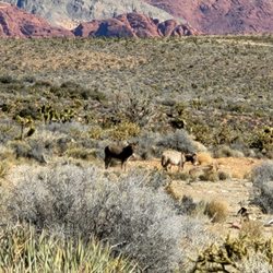
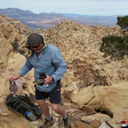
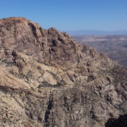
Such a cool loop! We're so lucky to have Red Rock Canyon so close to town and there are so many areas you can explore without entering the paid loop. This is one of them and I recommend checking out the little town of Blue Diamond as well where you can park safely and then go exploring. The loop itself is just under 8 miles. Depending on which part of it you hike your experience can include burros, an abandoned ranch, rubber ducks, and even a shot up classic car. This particular loop is free. You can begin the trail from several different areas. There's no shade so best time to be here is on much cooler days typically Oct - Apr. Also keep in mind that desert weather can turn on you very quickly so sometimes your hike starts with blue skies but can end up with clouds or even rain. So take advantage of the best time of year in Vegas which is now! Explore beyond Red Rock Canyon loop and have a lot of fun. read more


Great time at Landmine, Spanish trail to rubber ducky always a good time especially when the weather is this nice. If you go it's best the day after a mice rain. If it has rain d in a while then you'll probably encounter more loose gravel but that's ok because it just adds to the challenge. You can start your ride from Blue Diamond or leave a vehicle at Blue Diamond and shuttle up to "Late Night" on Blue Diamond highway. From "Late Night" you can take trails like: Mustang, viagra to land mine and then back into Blue Diamond. So many different trail systems! Lots of good inclines and fast down hills. read more


More info about Landmine Loop
Red Rock Canyon National Conservation Area
Landmine Loop
Blue Diamond, NV 89004
Directions
Hours
Outdoor Amenities
You might also consider


Landmine Loop - hiking - Updated July 2026
Best of Blue Diamond
People found Landmine Loop by searching for…
Abandoned Places in Blue Diamond, Nevada
Off Road Trails in Blue Diamond, Nevada
Hot Springs in Blue Diamond, Nevada
Campgrounds in Blue Diamond, Nevada
Scenic Drive in Blue Diamond, Nevada
Creeks in Blue Diamond, Nevada
Camping Sites in Blue Diamond, Nevada
Walking Trails in Blue Diamond, Nevada
Things to Do in Blue Diamond, Nevada
Mountain Biking in Blue Diamond, Nevada
Bike Paths in Blue Diamond, Nevada
Hiking Trails in Blue Diamond, Nevada
Waterfall Hike in Blue Diamond, Nevada
Night View in Blue Diamond, Nevada
Hiking Groups in Blue Diamond, Nevada
Canyoneering in Blue Diamond, Nevada
Ghost Towns in Blue Diamond, Nevada
Duck Pond in Blue Diamond, Nevada
Photo Spots in Blue Diamond, Nevada
Trails in Blue Diamond, Nevada
Tent Camping in Blue Diamond, Nevada
Trending Searches in Blue Diamond, NV
Black Owned Nail Salons in Blue Diamond, NV
Boat Rental in Blue Diamond, NV
Cliff Jumping in Blue Diamond, NV
Dog Swimming in Blue Diamond, NV
Jet Ski Rental in Blue Diamond, NV
Kayak Rental in Blue Diamond, NV
Lakes & Ponds in Blue Diamond, NV
Off Road Trails in Blue Diamond, NV
Outdoor Activities in Blue Diamond, NV
Parks For Picnics in Blue Diamond, NV
Pool Day Pass in Blue Diamond, NV
Public Pools in Blue Diamond, NV
Public Shower in Blue Diamond, NV
River Swimming in Blue Diamond, NV
Rock Quarry in Blue Diamond, NV
Scenic Night View in Blue Diamond, NV
Scenic Overlook in Blue Diamond, NV
Secluded Spots in Blue Diamond, NV
Soccer Store in Blue Diamond, NV
Splash Pad in Blue Diamond, NV
Swimming Holes in Blue Diamond, NV
Swimming Lakes in Blue Diamond, NV
Browse Articles
Browse Nearby
Browse Brands
Related Searches in Blue Diamond, NV
Affordable Canoe Rental Options in Blue Diamond, Nevada
Best Dog Hiking Trails Around Blue Diamond, Nevada
Best Fishing Locations and Guides in Blue Diamond, Nevada
Best Places for Horseback Riding in Blue Diamond, Nevada
Best Sightseeing Experiences Available in Blue Diamond, Nevada
Check Out Off Road Trails in Blue Diamond, Nevada
Discover Dog Friendly Trails to Explore in Blue Diamond, Nevada
Discover Popular Bike Trails in Blue Diamond, Nevada
Discover Scenic Mountain Bike Trails Near Blue Diamond, Nevada
Discover the Best Night Hike Trails in Blue Diamond, Nevada
Dog-Friendly Hikes With Dogs in Blue Diamond, Nevada
Enjoy Camping Adventures Around Blue Diamond, Nevada
Enjoy Kayaking Adventures in Blue Diamond, Nevada
Enjoy Off Leash Dog Hikes in Blue Diamond, Nevada
Enjoy Tent Camping Spots Around Blue Diamond, Nevada
Enjoy the Best Picnic Spots and Ideas in Blue Diamond, Nevada
Enjoy the Best Walking Path in Blue Diamond, Nevada
Enjoy the Best Walking Trails in Blue Diamond, Nevada
Explore Beautiful Parks and Green Spaces in Blue Diamond, Nevada
Explore Easy Hikes Perfect for All in Blue Diamond, Nevada
Explore Fun Activities to Do in Blue Diamond, Nevada
Explore Popular Campgrounds Near Blue Diamond, Nevada
Explore Popular Dog Walking Trails in Blue Diamond, Nevada
Explore Top Dog Parks in Blue Diamond, Nevada Near You
Explore Top Water Parks in Blue Diamond, Nevada Today
Family Friendly Hiking With Kids in Blue Diamond, Nevada
Find Cozy Camping Cabins in Blue Diamond, Nevada
Find Parks and Recreation Activities in Blue Diamond, Nevada
Find Popular Ziplining Spots Around Blue Diamond, Nevada
Find Top-Rated Waterfalls in Blue Diamond, Nevada Now
Find the Best Parks BBQ Grills in Blue Diamond, Nevada
Find the Best Parks for Picnics in Blue Diamond, Nevada
Find the Best Playgrounds to Visit in Blue Diamond, Nevada
Hiking Trails With Waterfalls in Blue Diamond, Nevada
Off Leash Dog Hiking Trails in Blue Diamond, Nevada
Perfect Spots to Watch Sunset in Blue Diamond, Nevada
Picnic Areas With BBQ Pits Available in Blue Diamond, Nevada
Play at a Splash Pad Park in Blue Diamond, Nevada
Popular Outdoor Activities to Try in Blue Diamond, Nevada
Popular Picnic Spots to Visit in Blue Diamond, Nevada
Safe and Fun Parks for Kids in Blue Diamond, Nevada
Top Hiking Trails to Explore in Blue Diamond, Nevada
Top Playgrounds for Kids to Enjoy in Blue Diamond, Nevada
Top Running Trails to Explore in Blue Diamond, Nevada
Top Swimming Lakes to Enjoy in Blue Diamond, Nevada
Top Swimming Spots and Pools in Blue Diamond, Nevada
Top Things to Do With Kids in Blue Diamond, Nevada