Lake Tabeaud Photos


You might also consider
More like Lake Tabeaud
Recommended Reviews - Lake Tabeaud
Start your review...

8 months ago


2 years ago
Just a very nice 2 1/2 mile walk around this pretty lake. Nothing special necessarily, but very pretty. read more
3 years ago
Get there earlier 6am Hiking trail 2.5miles around the lake Small parking lot Fishing Trouts Bathroom available read more


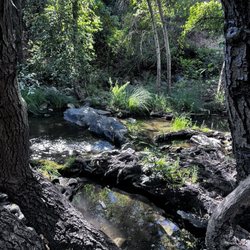
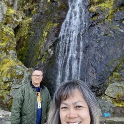
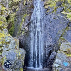
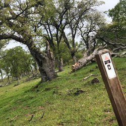
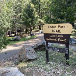
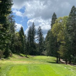
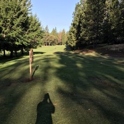
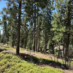
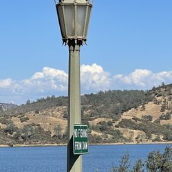
I have been to Lake Tabeaud a few times over the last few years to walk and enjoy the outdoors. I met a friend here last week for a hike as I thought it would be a good in-between meeting spot. The lake is lovely and there were lots of people there fishing, even on a weekday. There are shady spots with picnic tables and nice views of the water. The "loop" around the lake is said to be just over 2 miles but it can be very difficult to follow. Although I have done it before, some parts have washed out since my last visit and the trail isn't marked. Part of the trail is wide and you pass by a few homes. Part of the trail is narrow and windy. There are also a few spots with moderate incline but I would still rate the difficulty level as easy. There is a decent amount of shade but not enough to do this trail without adequate sunblock and a hat. I love that it is dog friendly and plenty of people do this trail off-leash. There are also bathrooms in the one of the two parking lot areas and they have a fantastic sign outside telling you where you are, where to call in an emergency and/or how to get to the nearest hospital. I have included a photo. I have never seen this before but it's brilliant. You can easily do this trail in an hour or take your time and spend an afternoon. read more


3 years ago
3 years ago
3 years ago
6 years ago
More info about Lake Tabeaud
Tabeaud Rd
Jackson, CA 95642
Directions
Hours
Indoor Amenities
Outdoor Amenities
Ask the Community - Lake Tabeaud
You might also consider


Why does Yelp recommend reviews?
2 reviews that are not currently recommended
The reviews below are not factored into the business's overall star rating.
4 years ago
3 years ago
Lake Tabeaud - hiking - Updated July 2026
Best of Jackson
People found Lake Tabeaud by searching for…
Fishing in Jackson, California
Things to Do in Jackson, California
Swimming Holes in Jackson, California
Fishing Spots in Jackson, California
Hiking Trails in Jackson, California
Trout Fishing in Jackson, California
Swimming Lakes in Jackson, California
Dog Friendly Hiking Trails in Jackson, California
Off Road Trails in Jackson, California
Trout Farm in Jackson, California
Picnic Areas in Jackson, California
Dog Swimming in Jackson, California
Running Trails in Jackson, California
Swimming in Jackson, California
Fishing Lake in Jackson, California
Lakes & Ponds in Jackson, California
Walking Trails in Jackson, California
Secret Spots in Jackson, California
Off Leash Dog Hiking Trails in Jackson, California
Dog Friendly Things to Do in Jackson, California
Kayak Rental in Jackson, California
Trending Searches in Jackson, CA
4th Of July Fireworks near Lake Tabeaud
Black Owned Nail Salons near Lake Tabeaud
Cliff Jumping near Lake Tabeaud
Dog Friendly Trails near Lake Tabeaud
Fishing Spots near Lake Tabeaud
Flower Fields near Lake Tabeaud
Jet Ski Rental near Lake Tabeaud
Kayak Rental near Lake Tabeaud
Lakes & Ponds near Lake Tabeaud
Off Road Trails near Lake Tabeaud
Outdoor Activities near Lake Tabeaud
Outdoor Basketball Courts near Lake Tabeaud
Picnic Areas near Lake Tabeaud
Public Pools near Lake Tabeaud
Public Shower near Lake Tabeaud
River Swimming near Lake Tabeaud
Running Trails near Lake Tabeaud
Scenic Restaurants near Lake Tabeaud
Secluded Spots near Lake Tabeaud
Soccer Store near Lake Tabeaud
Strawberry Picking near Lake Tabeaud
Sunrise View near Lake Tabeaud
Swimming Holes near Lake Tabeaud
Swimming Lakes near Lake Tabeaud
Volleyball Courts near Lake Tabeaud
Watch Sunset near Lake Tabeaud
Browse Nearby
Browse Brands
Related Searches in Jackson, CA
Best Fishing Locations and Guides in Jackson, California
Best Off Leash Dog Parks in Jackson, California
Best Parks for Parties and Events in Jackson, California
Best Places for Horseback Riding in Jackson, California
Best Sledding Spots and Fun in Jackson, California
Best Water Parks for Kids in Jackson, California
Best Waterfalls and Swimming Holes in Jackson, California
Check Out Off Road Trails in Jackson, California
Discover Dog Friendly Beaches Near Jackson, California
Discover Dog Friendly Trails to Explore in Jackson, California
Discover Lakes & Ponds to Explore in Jackson, California
Discover Popular Photo Spots in Jackson, California
Discover Scenic Mountain Bike Trails Near Jackson, California
Discover Scenic Waterfall Spots in Jackson, California
Discover Soccer Fields in Jackson, California Near You
Discover Top Nature Parks to Visit in Jackson, California
Discover a Hiking Trail in Jackson, California
Discover the Best Beaches in Jackson, California
Discover the Best Fishing Lake in Jackson, California
Discover the Best Night Hike Trails in Jackson, California
Discover the Best Running Track in Jackson, California
Enjoy Camping Adventures Around Jackson, California
Enjoy Exciting Mountain Biking Adventures in Jackson, California
Enjoy River Tubing Adventures in Jackson, California
Enjoy Tent Camping Spots Around Jackson, California
Enjoy the Best Picnic Spots and Ideas in Jackson, California
Enjoy the Best Walking Trails in Jackson, California
Exciting Cliff Jumping Spots in Jackson, California
Experience Stunning Sunset Views in Jackson, California
Explore Beautiful Parks and Green Spaces in Jackson, California
Explore Bike Rentals Throughout Jackson, California
Explore Easy Hikes Perfect for All in Jackson, California
Explore Fun Activities to Do in Jackson, California
Explore Jet Skis for Sale or Rent in Jackson, California
Explore Parks With Lakes to Visit in Jackson, California
Explore Popular Campgrounds Near Jackson, California
Explore Popular Picnic Areas Around Jackson, California
Explore Popular RV Parks Around Jackson, California
Explore Popular Scenic Views Near Jackson, California
Explore Popular View Points Around Jackson, California
Explore Scenic Lakes to Visit in Jackson, California
Explore Top Dog Parks in Jackson, California Near You
Explore Top Water Parks in Jackson, California Today
Explore the Best Beach Spots in Jackson, California
Explore the Best Boating Spots in Jackson, California
Explore the Best Swimming Holes Around Jackson, California
Family Friendly Hiking With Kids in Jackson, California
Find Beautiful Views in Jackson, California
Browse Articles
People who viewed Lake Tabeaud also viewed
Volcano Park
2 reviews
Indian Grinding Rock State Historic Park
56 reviews
Sutter Creek Lions Park
1 review
Mokelumne Coast to Crest Trail
3 reviews
Pardee Lake Recreation
44 reviews
Kennedy Tailing Wheels Park
10 reviews
Pine Grove Community Park
3 reviews
Howard Park
2 reviews
Plymouth City of
4 reviews
San Andreas Community Park
1 review