Cancel

    Open app

    Search

    Laguna Lake Trail

    3.0 (1 review)

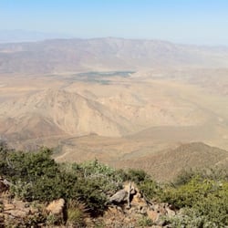
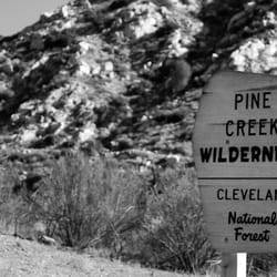
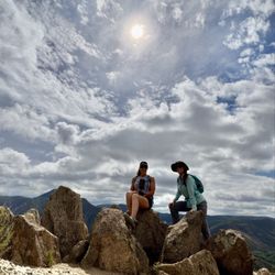
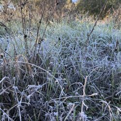
    Laguna Lake Trail Photos

    You might also consider

    More like Laguna Lake Trail

    Recommended Reviews - Laguna Lake Trail

    Your trust is our priority, so businesses can't pay to alter or remove their reviews. Learn more about reviews.
    Yelp app icon
    Browse more easily on the app
    Review Feed Illustration
    Photo of Nobu S.
    40
    28
    125760

    3 years ago

    Helpful 0
    Thanks 0
    Love this 0
    Oh no 0

    You might also consider

    Verify this business for free

    People searched for Hiking 234 times last month within 15 miles of this business.

    Verify this business

    Cottonwood Creek - Swimming in the river, before it got very crowded

    Cottonwood Creek

    4.7(7 reviews)
    5.1 mi

    It's a great river swim with the family…read more However be very careful.. I feel in a whole in Sept 5th,2022 and twisted both ankles. Which I'm still suffering pain from Two month in my injury. My family had lots of fun( I didn't since I was in pain but since it was 2hr drive I suck it up for them). My toddler love it.. we went when LA hit over 100* heat... it very nice in the water!! Many ppl with floating I do suggest to make sure everyone know how to swim as its now drag ppl down the stream..

    I could see this being a 3 or 4 star hike depending on the season and weather conditions you do the…read morehike in. I hiked it on 2/24/19 and found the conditions to be ideal for my enjoyment! Location- it was only about a 30 minute drive for me since I spent the night after attending a party at a family member's house in El Cajon (suburb of San Diego); I jumped on the 8 East and as the elevation reached 3,000 ft I could begin seeing snow on the hills near the fwy and I got even more excited for this hike- took Exit 47 for Sunrise Hwy and the trailhead parking was about 2 miles away from the fwy and there was a large lot on the side of the hwy to park Trail- you access the trail by walking across the road and going to the right of the metal barrier...the snow was the deepest on this portion of the hike for about half a mile and the first part of the hike is where the trail is the narrowest with portions where you have to bend over and get low to continue past low branches; at about 3/4 of a mile you will get down to creek level and make a left to get to the waterfalls...I carefully climbed up to reach about 4 parts of the waterfall and it was flowing really well with all of the recent precipitation of this winter and it was a pleasant surprise to find this so close to the city of San Diego; it is about 2 miles RT and not anything too extreme in the way of incline and I loved having the trail/falls all to myself for the nearly 2 hrs I was there *I used microspikes just to be safe but I could see it being fine with just hiking shoes

    Photos
    Cottonwood Creek - Watching from the bank since I was injured I would walk my ankles were beyond swallowed...

    Watching from the bank since I was injured I would walk my ankles were beyond swallowed...

    Cottonwood Creek - Seeing the lake before getting to the river

    Seeing the lake before getting to the river

    Cottonwood Creek - Cows on our way to the river.. leaving LA behind us

    See all

    Cows on our way to the river.. leaving LA behind us

    Pacific Crest Trail At Penny Pines - Beauty that you will see on the Indian Creek trail loop in Mt Laguna

    Pacific Crest Trail At Penny Pines

    4.9(22 reviews)
    1.1 mi

    INDIAN CREEK LOOP REVIEW (8.8 miles)…read more Let's begin with 100% of hikes in Mt. Laguna or that includes the PCT will be an ethereal experience. Many say you can create, shape and mold reality. Others will say manifest and it will come. And then there are some that are just bah humbug. I always revel in God's imagination and creativity when he created these mountains. And then gave the gift of ingenuity to humans to work to create pathways and trails for us to enjoy and simply relish in gratitude and awe the entire hike. I'm a real hiker. Real backpacker. Real camper. And real glamping. I hike 2x a week for more than a decade. This is only to give you perspective of this review. This is my first time doing the full loop that included Pacific Crest Trail,Pine Mountain Road,Indian Creek Trail,and Noble Canyon Trail AKA "Indian Creek Loop." And today was wonky. Some parts were hard, some parts were easy, same parts were as if my body never has done hiking before. It was a doozy. I would likely do this hike again within the next couple of weeks. Because in my imagination, I'm an amazing hiker and that did not show today when I was struggling. I love taking photos and there was about an hour where I was trying to manage my breathing and focus and trek poles that I took no photos. Yep, I let the mountain win, smh. On this day, spectacular hike with alternating elevation, endless greenery, and blooming plants. Walking the legendary PCT, passing the "Canada" sign, and glimpsing Anza Borrego's desert floor was unforgettable. From rocky paths to meadows and mountain views, every turn offered something new. No one on the trail until the final half mile where bikers were on trail. I started at Piney Pines. Next time I'll go counterclockwise. GOOD TO KNOW *Att network excellent reception the entire trail *I felt safe as a solo hiker but I still get the quesies. I carry a few safety thins. Shhh. Don't tell *Hike time: 3 hrs, 3 minutes *90% exposed hike. *At the 4 mile marker, shade, benches and toilets. The toilets are unsanitary. I don't want to vomit and make it worse so I do my thing in nature. *When you start there's a point where you just have to finish *You can break this up to build up your mileage over time THIS HIKE IS NOT FOR: *Newbies, there's elevation involved *Whiners, complainers, or scaredy cats *Those who I have only done Cowles Mountain and think this is the next level "Life can be limited and you miss out. But create your own unlimitedness and you must do this hike."

    This review is for the Garnet Peak via Pacific Crest Trail which was a 4 mile round trip that took…read moreabout 2 hours to complete. The trail for the most part was easy to follow and completely exposed to the sun. A good portion of the trail was rocky which could make your foot a bit uncomfortable. There were also a few instances where you could go off trail for a bit to check out the desert views! Short video of the hike for those interested: https://www.youtube.com/watch?v=htU3_t3cDMI

    Photos
    Pacific Crest Trail At Penny Pines - Beauty that you will see on the Indian Creek trail loop in Mt Laguna Garnet Peak

    Beauty that you will see on the Indian Creek trail loop in Mt Laguna Garnet Peak

    Pacific Crest Trail At Penny Pines
    Pacific Crest Trail At Penny Pines

    See all

    Sunrise National Scenic Byway

    Sunrise National Scenic Byway

    4.5(2 reviews)
    2.4 mi

    San Diego's most underrated drive is best experienced during fall when the gold and amber oak trees…read moreare brilliant with the season's color. Because of this byway's location most people tend to stay around Julian and Cuyamaca to hike. There are some trails off of this road which are a lot less crowded but just as fun. - Big Kahuna Trail (yelp erroneously has this trail under Rancho Bernardo CA) - Monument peak off the PCT (puts you under all the cool transmission towers) WINTER SNOW is also a popular time to come here as it's less crowded than Palomar Mountain, Julian and Cuyamaca snow spots. But less crowded is still very crowded. Tips: Always plan to bring snow chains. Sometimes the road is shut down to "chains only" as a way to curb insane crowds. Perhaps the biggest tip is to get to the snow early. Before 9am is best. People who show up later on a whim cause the most problems. The later it is the more accidents you'll see. I've witnessed this stupidity myself while driving back down the mountain. The sooner you arive the safer you and your family will be. Don't expect any parking after 11AM.... When you do find a spot hopefully you're facing the road back to your house. Trying to do a theee point turn is difficult on this narrow road and I watched some idiot back into a parked car trying to do it. Top- If you don't bring gloves you'll be turning around and going home within 30 minutes.

    My favorite place in SD county to experience those lush pine forest vibes and snow during the…read morewinter time. If you're able to come here on a weekday, I recommend it, as you'll pretty much have the entire place to yourself. I choose this place over Palomar Mountain hands down, there's actually a place to eat here and the views are nicer IMO. If you get a chance, check out the Desert View Picnic site, you'll be able to see some breathtaking views of Anza Borrego State Park and contrast both the mountain/desert landscapes.

    Photos
    Sunrise National Scenic Byway - Green moss white snow

    Green moss white snow

    Sunrise National Scenic Byway
    Sunrise National Scenic Byway

    See all

    Monument Peak Hike - Mountain Lion tracks in hardened mud

    Monument Peak Hike

    4.7(3 reviews)
    0.2 mi

    A great (Loop) hike that is best experienced during fall…read more.. There are many ways to hike this trail, but mine is a 5 mile loop hike. Follow my suggestions and get a great family-friendly hike with great views, fresh air, and you'll get up close to microwave towers, a USAF Doppler radar ball, and cellular towers. Soo cool. Okay, you've put this hike on your list based on the pictures but there are a few thing you need to know. I started at the Desert View picnic area. This is a great parking area but you MUST have an adventure pass to park here. You'll have to buy a day, or annual park pass at any sports/adventure store. OR, I found a free parking alternative. Okay here we go. I'll talk about the free parking..If you're at the picnic area just hop on the PCT and head north.. The access to the free parking area it's the next North turnoff past the Desert View picnic area. Drive up the road to the lot and park in the dirt lot.. Check out the view!! For your reference look up the road and you'll see a big black gate.. this is where your loop hike will END... Don't worry, you will not be trespassing on this hike. That gate only blocks cars, not hikers. My loop starts at the Pacific Crest Trail, so if you parked at the free area walk down the road and look for the trailhead on the RIGHT side of the road.. TIP - Because this area doesn't have reliable cell service you will need to use GPS via Google Maps (or a hiking app) to find the actual "unmarked Monument trail". TIP if you can't use google maps, you'll have to look for the PCT marker that's at the base of a small hill.. just look for a tight opening through manzinita trees on the right just before that sign. The monument trail is tight, but you can do it. Hike to the top and hike around the various government installations..take pictures..have fun. To complete the loop, continue to walk down the service road past more towers and dome heading south.. it will take you all the way back to the viewpoint parking lot.. TIPS - Put the location of the Desert View picnic area in your google maps app for reference BEFORE you enter this area (no internet coverage up here). Remember if you park at the picnic area you need an adventure pass. No pass required if you park at the viewpoint lot. This loop didn't have a single no trespassing sign. So do walk the service road on the loop back.

    The views at the top are spectacular. Tall Pines to the west, dry desert to the east. This peak…read morelies on what is known as a ecotone. A boundary between two distinctly different habitats. I used the directions provided here and they got me to a parking area off the shoulder on Sunrise Highway, about mile marker 25. The trailhead has between a barbed wire fence and the trail unmarked. You walk in a northerly direction for about half mile or so through a trail that looks vague in places do to lack of use, apparently. I got this info from a great hiking book called Afoot and Afield San Diego County by Jerry Schad. You'll walk until you get to another trail that intersects, and it's not marked. Follow it right on you'll be on the Big Laguna trail. Walk about 100 yards until you get to another trail intersection. It's the Pacific Crest trail and you'll follow it left. At the summit is a few radio and microwave antennas. Of interest was a laser target, standing about 6ft tall. I snapped a photo and uploaded it. When at the summit you'll appreciate the beautiful contrast of habitat as you pan around 360 degrees. It was especially windy this day, but very clear providing great views. Mount Stephenson and the large round white antennae towers can also be visited very near by. The views of the desert are amazing. This is an easy hike of about 4 miles out and back. Elevation gain 500 feet

    Photos
    Monument Peak Hike - You can see forever

    You can see forever

    Monument Peak Hike - Side hike to Stephenson Peak. Observe these signs. Government is not kidding

    Side hike to Stephenson Peak. Observe these signs. Government is not kidding

    Monument Peak Hike

    See all

    Secret Canyon Trail - Wildflowers in January!

    Secret Canyon Trail

    4.5(6 reviews)
    16.4 mi

    Alltrails lists this as 'Horse thief Canyon', then I saw that I had this listing bookmarked on Yelp…read morefor sometime and noticed that they were the same thing! Distance: ~3.3mi., reverse out-and-back (you will be going uphill on the return trip) Difficulty: easy-intermediate-ish (~0.5mi ascent on your way out which can get the heart pumping!) Time: 1.5-2 hours Permit required?: No (according to permit site - https://www.fs.usda.gov/detailfull/r5/passes-permits/?cid=stelprdb5208699&width=full) Sights of Interest: Mini waterfall and pool Parking is in a big dirt lot just off of Japatul Lyons Valley Rd.. Turn in at Forest Rt 16S04. No bathrooms, so bring some T.P.! There are three gates as you approach - two smaller ones and a large one leading to a service road. Take the gate with a sign marking the 'Epinosa Trail to Secret Canyon Trail'. You'll end up on the service road either way. Continue on the service road until you see a sign off to the right that says 'Trail'. This is where you'll begin the descent into Horse thief Canyon. Eventually it evens out into a nice shady area alongside a stream. Lots of vegetation and growth everywhere, so make sure to *bring the bug spray*! There's a stream crossing after which you'll come upon the pool! Lots of great places to hang out on and relax on boulders. Water is pretty clean for swimming too. Awesome place to bring your dogs to cool off after the dusty trail. Just remember to pack your trash out if you plan on picnic-ing down at the pool! Most of your journey is on the Epinosa Trail and supposedly the Secret Canyon Trail is just beyond the pool, but the trail doesn't seem to continue anywhere beyond it. Great trail either way that experiences very little foot traffic so the area is very well preserved and wild! FYI, apparently this area experiences an influx of illegal immigrants and smugglers, but I think that was in earlier years. It was pretty safe when I went and I only had my dog in tow. But, I like to live life on the edge, so if you are wary come with a group!

    If you go during the week during normal business hours this trail is dead! It was our 2nd time here…read moreand there was only 1 car in the parking lot and we never even ran into the people. This is nice but also kind of scary especially since it's kind of in the middle of nowhere and you don't have great service but luckily I am alive today to write this review. The first time we went on this hike we missed the path and ended up just heading straight through on a dirt road so pay attention on your right hand side for a sign marked trail. This trail would have gotten more stars if it wasn't for the ridiculous amount of flies. I almost turned back because I couldn't stand them constantly flying in my face and in my ears. Maybe I am not an outdoorsy person if I cant handle that but it was hard to enjoy this hike when I was having to smack flies away the whole time. This is also one of those hikes that is fairly easy on the way down but tough on the way back because you have to go back up. I will say though that it was a really pretty hike and there is a creek at the bottom. We didn't go the whole way but did about a little over 3 miles of it. It's about a mile and a half to see the beginning of the creek. Maybe wearing bug spray might help with the flies?

    Photos
    Secret Canyon Trail - Trail is pretty well marked

    Trail is pretty well marked

    Secret Canyon Trail - Awesome sign.

    Awesome sign.

    Secret Canyon Trail

    See all

    Cedar Creek Falls - Cedar Creek Falls

    Cedar Creek Falls

    4.4(358 reviews)
    16.6 mi

    If you are a San Diego hiker and haven't done this hike- WHAT ARE YOU WAITING FOR???…read more And for those of you who see these photos and think damn I need to go do that, please be aware of the temperature because it is dangerously hot down there at lower temperatures than in other areas. The hike goes down into a canyon and the heat settles down there. Even if it's not as hot as you think coming up can be extremely dangerous. Every year I hear about somebody dying from heat stroke on that hike so don't take it lightly. I always check the weather on the actual trail using the AllTrails app. I saw that the weather out there was max 65° that day and I was like hell yeah. The hike really isn't that difficult, 3 miles down and then 3 miles back up. Lots of nice switchbacks, and there are a few sun shelters for shade. The views are gorgeous all along the trail. I've done this hike, probably 20 times over the years. It's the best in the spring and in the fall. In the winter it's way too cold. The reward for this hike is the gorgeous rock bowl and waterfall that the locals call Devils Punchbowl. This past Thursday when we did this hike, there were a lot of young folks at the Punchbowl when we got there. Some of the guys were climbing up and jumping into the water. I would not recommend it, even if the waterfall is still flowing that water is not safe to swim in. In the fall, the waterfall doesn't flow anymore after being dried out over the brutal summer, but the trees at the bottom of the canyon turn a beautiful gold color. One of the few places in San Diego you can actually experience fall.

    Having lived in San Diego for so long, I honestly don't know why it took me this long to do this…read morehike. I finally got the permit online (definitely download it before you arrive since service can be spotty) and decided to go for it. I went in early May and started the trail around 8am, which turned out to be a great decision. The trail was practically empty at that time, and the downhill views were absolutely beautiful. I even saw two rattlesnakes before 9am, so definitely stay alert while hiking. At several points I had to remind myself I was still in San Diego and not somewhere in a huge national park. Once I got near the bottom, I did lose track of the trail a little and it was SOS, so having the AllTrails map downloaded beforehand was really helpful. It took me a little over an hour to reach the waterfall, and there were only two other people there at the time, which made it feel really peaceful and private. The water felt AMAZING after the hike down. There were so many fish in the water, and the whole area was honestly so pretty. By the time I started heading back around 10am, I noticed a lot more people arriving at the falls. The hike back up wasn't terrible, but the sun definitely makes it much harder on the return. I was very happy to make it back to the parking lot by around 11:30am. I would definitely bring lots of water, sunscreen, and some snacks.

    Photos
    Cedar Creek Falls - Cloud porn in the beginning of our hike!

    Cloud porn in the beginning of our hike!

    Cedar Creek Falls - Awesome day with one of my best girlfriends

    Awesome day with one of my best girlfriends

    Cedar Creek Falls - Morning frost

    See all

    Morning frost

    Volcan Mountain Preserve - Mountain Lion tracks

    Volcan Mountain Preserve

    4.6(87 reviews)
    17.3 mi

    We tackled Volcan Mountain Trail with an eight-year-old, so we didn't make it the full way but it…read morewas such a nice experience. We also brought along our dog as it is a dog friendly trail as long as your dog is on a leash. The trail starts out pretty steep, but it's well-marked with clear paths throughout. One thing I really loved was all the signage explaining local plant life and animal tracks so it made the hike feel educational and engaging. My kiddo was really into looking at the different animal paw prints. This trail is great for hiking enthusiasts and beginners alike but just know your limits and pace yourself if you're newer to hiking. I would definitely say if it's sunny to make sure you bring plenty of water with you, but there are a lot of shady spots on this trail so that is a nice change from the hikes that are closer to coastal San Diego.

    It's a good hike to pair with a trip to Julian. My husband and I picked up sandwiches in town for a…read morepicnic on the trail. Parked next to the road and knew we were in the right place because of all the other cars. We made our hike a loop as we went up the mountain, taking the 5 Oaks Trail, and then came down using the Vulcan Mountain preserve trail. The 5 Oaks Trail has more of a view. There are a few seats to stop, sit (catch your breath) and enjoy the view. Sadly, we haven't had rain so it wasn't as green as I'm sure it would be on a normal January. Nevertheless, a great hike to work off all the apple pie you eat in Julian.

    Photos
    Volcan Mountain Preserve - Sign at the trailhead

    Sign at the trailhead

    Volcan Mountain Preserve
    Volcan Mountain Preserve

    See all

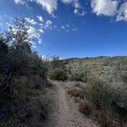
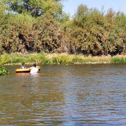
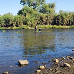
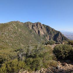
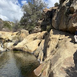
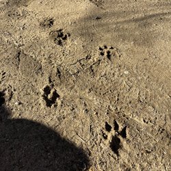
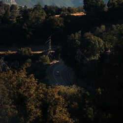
    Laguna Lake Trail - hiking - Updated May 2026

    Loading...
    Loading...
    Loading...