Koser Park Photos


More like Koser Park
Recommended Reviews - Koser Park
Start your review...

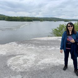
The white cliffs of conoy is located here, which is roughly a 3 mile trek round trip (1.5 miles one way). Parking is limited in Koser Park. When heading towards the paved trail that is tree lined, take the paved path opposite of the side the picnic tables (on your right if your back is to the Susquehanna river). The trail can get quite busy, numerous people bike down the trails, others are just walking &/or walking their dogs. You eventually cross a small bridge, once you hit the 1.5 mile mark you will come up on a port a potty on your right. You can enter the first mound by walking through the overgrown brush/trees. The view from the first mound doesn't have as much impressive views as the second mound. When we arrived there were two kids biking on the first mound. The white cliffs of conoy was named after the resemblance of the white cliffs of Dover, however these mounds are actually industrial waste from crushed excess limestone & dolomite fused from an old limestone quarry that was once private land, but is now publicly owned. The second mound can be accessed if you walk a few feet past the port a potty, take caution as there are old metal rods etc poking out through the mound in various areas. There are also signs to take caution away from the ledge, as some of the areas can be unstable. The view of the Susquehanna River is beautiful. Are the white cliffs of conoy impressive? Not necessarily, but it's something unique, & quirky to see in person. It's also a popular spot for engagement/proposal photos for the locals. I wouldn't say it's a must see, but if you are out of state visiting, it's a nice short, paved easy hike that will probably last roughly an hour or so, dependent upon your speed & physical fitness level. You can combine this hike with the Chickies rock overlook trail, as it is only a 15 minute drive from one another. When leaving to head back to Hershey, we drove pass Three Mile Island, where the unit 2 reactor partial meltdown caused roughly 2 million people living nearby to be exposed to small amounts of radiation. read more


2 years ago
Absolutely Beautiful and not a bad walk about 2.5 miles to the white cliffs of Conoy. Partially covered and paved trail with mini trails leading towards the water. read more


The best trailhead for the NW Lancaster County River Trail IMO. There are 3 Porta Johns and a pub right across the street. From here you can either head north towards Falmouth for 3 miles on a brand new paved trail, and/or head 1.5 miles south to White Cliffs of Conoy where you can have a nice excursion/photo op. For the die hard bikers, the trail goes 6.5 mile uninterrupted to Decatur St in Marietta, or you can go all the way down to Columbia for 12 miles. The river trail is level and fully paved. The view here is picture perfect, with many benches facing the river. There's also a pavilion for a group picnic. Down the slope where the boat launch is has another nice view of the Susquehanna River; don't miss it. read more


9 years ago
The humans were out and about today at Koser Park, including all 9 of us! We parked our car here and sat to watch the swollen Susquehanna River whose current was moving rapidly with debris in it that we half expected to see a house float by. Afterwards, we walked towards the White Cliffs of Conoy on this beautiful day. Note this trail has walkers, dog walker, skate boarders, mountain bikers and racing bikes (also known as 10 speed). NOT an ideal place for racing bikes, as some people want to take a stroll or are handicapped like my pops and can't move quickly. The path is wide, but during busy beautiful days, there are many people are on the trail. I wouldn't recommend clipping shoes to your bike on this trail. Please be courteous and kind on this trail as many families and children are trying to enjoy getting out too. read more


More info about Koser Park
107 Race St
Bainbridge, PA 17502
Directions
Hours
Outdoor Amenities


Koser Park - hiking - Updated June 2026
Best of Bainbridge
People found Koser Park by searching for…
Photo Spots in Bainbridge, Pennsylvania
Parks in Bainbridge, Pennsylvania
Things to Do in Bainbridge, Pennsylvania
Places to Take Pictures in Bainbridge, Pennsylvania
Hiking Trails in Bainbridge, Pennsylvania
Walking Trails in Bainbridge, Pennsylvania
Scenic Overlook in Bainbridge, Pennsylvania
Off Road Trails in Bainbridge, Pennsylvania
Dog Friendly Trails in Bainbridge, Pennsylvania
Picnic Areas in Bainbridge, Pennsylvania
Lookout Points in Bainbridge, Pennsylvania
Rock Quarry in Bainbridge, Pennsylvania
Easy Hikes in Bainbridge, Pennsylvania
Running Trails in Bainbridge, Pennsylvania
Swimming Holes in Bainbridge, Pennsylvania
Picnic Spots in Bainbridge, Pennsylvania
Scenic View in Bainbridge, Pennsylvania
River Walk in Bainbridge, Pennsylvania
Splash Pad in Bainbridge, Pennsylvania
River Swimming in Bainbridge, Pennsylvania
Beautiful Views in Bainbridge, Pennsylvania
Place to Propose in Bainbridge, Pennsylvania
Trending Searches in Bainbridge, PA
Browse Articles
Browse Nearby
BEST of Bainbridge, Pennsylvania Restaurants near Koser Park
BEST of Bainbridge, Pennsylvania Things to Do near Koser Park
BEST of Bainbridge, Pennsylvania Coffee near Koser Park
BEST of Bainbridge, Pennsylvania Parks near Koser Park
BEST of Bainbridge, Pennsylvania Playgrounds near Koser Park
BEST of Bainbridge, Pennsylvania Breakfast near Koser Park
BEST of Bainbridge, Pennsylvania Campgrounds near Koser Park
Browse Brands
Related Searches in Bainbridge, PA
Affordable Bike Tune Up Services in Bainbridge, Pennsylvania
Affordable Mobile Bike Repair in Bainbridge, Pennsylvania
Best Dog Hiking Trails Around Bainbridge, Pennsylvania
Best Electric Bike Rental Services in Bainbridge, Pennsylvania
Best Fishing Locations and Guides in Bainbridge, Pennsylvania
Best Lookout Points to Visit in Bainbridge, Pennsylvania
Best Nature Trails for Hiking in Bainbridge, Pennsylvania
Best Spots for Star Gazing in Bainbridge, Pennsylvania
Best Used Bikes for Sale Near Bainbridge, Pennsylvania
Best Waterfalls and Swimming Holes in Bainbridge, Pennsylvania
Check Out Off Road Trails in Bainbridge, Pennsylvania
Discover Dog Friendly Trails to Explore in Bainbridge, Pennsylvania
Discover Popular Bike Trails in Bainbridge, Pennsylvania
Discover Scenic Mountain Bike Trails Near Bainbridge, Pennsylvania
Discover Top Nature Parks to Visit in Bainbridge, Pennsylvania
Discover a Hiking Trail in Bainbridge, Pennsylvania
Discover the Best Night Hike Trails in Bainbridge, Pennsylvania
Dog-Friendly Hikes With Dogs in Bainbridge, Pennsylvania
Effective Stairs Workout Spots in Bainbridge, Pennsylvania
Enjoy Camping Adventures Around Bainbridge, Pennsylvania
Enjoy Exciting Mountain Biking Adventures in Bainbridge, Pennsylvania
Enjoy Hiking Adventures in Bainbridge, Pennsylvania
Enjoy Scenic Night View Experiences in Bainbridge, Pennsylvania
Enjoy Tent Camping Spots Around Bainbridge, Pennsylvania
Enjoy the Best Walking Trails in Bainbridge, Pennsylvania
Experience Stunning Sunset Views in Bainbridge, Pennsylvania
Explore BMX Bike Shops Near Bainbridge, Pennsylvania
Explore Easy Hikes Perfect for All in Bainbridge, Pennsylvania
Explore Electric Bikes Available in Bainbridge, Pennsylvania
Explore Free Things to Do Around Bainbridge, Pennsylvania
Explore Popular Campgrounds Near Bainbridge, Pennsylvania
Explore Popular Scenic Overlook Points in Bainbridge, Pennsylvania
Explore Popular View Points Around Bainbridge, Pennsylvania
Explore Scenic Lakes to Visit in Bainbridge, Pennsylvania
Explore Secret Spots Worth Visiting in Bainbridge, Pennsylvania
Explore the Best Boating Spots in Bainbridge, Pennsylvania
Explore the Best Swimming Holes Around Bainbridge, Pennsylvania
Explore the Best Trail Options in Bainbridge, Pennsylvania
Family Friendly Hiking With Kids in Bainbridge, Pennsylvania
Find Beautiful Views in Bainbridge, Pennsylvania
Find Cheap Bike Rentals Around Bainbridge, Pennsylvania
Find Cozy Camping Cabins in Bainbridge, Pennsylvania
Find Fun Kids Activities Outdoor in Bainbridge, Pennsylvania
Find Parks and Recreation Activities in Bainbridge, Pennsylvania
Find Popular Running Stairs Locations in Bainbridge, Pennsylvania
Find Top Mountain Bike Rental Options in Bainbridge, Pennsylvania
Find Top-Rated Waterfalls in Bainbridge, Pennsylvania Now
Find a Fixed Gear Bike Shop in Bainbridge, Pennsylvania
Find the Best Bikes Available in Bainbridge, Pennsylvania
Find the Best Playgrounds to Visit in Bainbridge, Pennsylvania