Indian Boundary Historical Marker Photos


More like Indian Boundary Historical Marker
Recommended Reviews - Indian Boundary Historical Marker
Start your review...

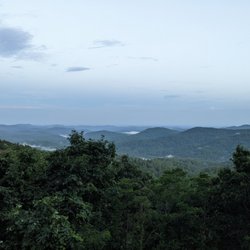
Along US Highway 441 (which goes from Miami Florida, across all of Georgia and into eastern Tennessee), this marker points out some of the Colonial History of the area. It's at an otherwise unassuming intersection so there is room to pull over to read the marker. It has the same text on both sides, reading "The boundary between the State of Georgia and the Cherokee Nation established by the Treaty of Augusta, May 31, 1783, ran along here. The line ran "from the top of Currahee mountain to the head, or source, of the most southern branch of the Oconee river, including all waters of the same. This boundary line was re-affirmed by the Treaty of Hopewell, Nov. 28, 1785. It was originally marked by a line of felled trees at least twenty feet wide, which became a sort of No Man's Land." The marker was erected in 1953 by the 1953 by Georgia Historical Commission and is marker number 006-1. The immediate area around it is overgrown but you can still read it here. [Review 21130 overall - 701 in Georgia - 93 of 2024.] read more


More info about Indian Boundary Historical Marker


Indian Boundary Historical Marker - landmarks - Updated May 2026
Best of Homer
People found Indian Boundary Historical Marker by searching for…
Trending Searches in Homer, GA
Botanical Gardens near Indian Boundary Historical Marker
Bounce House Rentals near Indian Boundary Historical Marker
Campgrounds near Indian Boundary Historical Marker
Cliff Jumping near Indian Boundary Historical Marker
Flower Shop near Indian Boundary Historical Marker
Free Picnic Areas near Indian Boundary Historical Marker
Garage Sales near Indian Boundary Historical Marker
Garden Center near Indian Boundary Historical Marker
Hair near Indian Boundary Historical Marker
Hidden Gems near Indian Boundary Historical Marker
Landmarks & Historical Buildings near Indian Boundary Historical Marker
Lookout Points near Indian Boundary Historical Marker
Nurseries & Gardening near Indian Boundary Historical Marker
Outdoor Furniture Stores near Indian Boundary Historical Marker
Party Equipment Rentals near Indian Boundary Historical Marker
Pedicure near Indian Boundary Historical Marker
Pick Your Own Farms near Indian Boundary Historical Marker
Places To Visit near Indian Boundary Historical Marker
Plant Nursery near Indian Boundary Historical Marker
Public Art near Indian Boundary Historical Marker
Secluded Spots near Indian Boundary Historical Marker
Strawberry Picking near Indian Boundary Historical Marker
Sunset View near Indian Boundary Historical Marker
Table And Chair Rentals near Indian Boundary Historical Marker
Browse Articles
Browse Nearby
Browse Brands
Related Searches in Homer, GA
Beautiful Flower Fields in Homer, Georgia
Best Fishing Locations and Guides in Homer, Georgia
Best Fun Things to Do in Homer, Georgia
Best Lookout Points to Visit in Homer, Georgia
Best Nature Trails for Hiking in Homer, Georgia
Best Observation Deck Views in Homer, Georgia
Best Places for Stunning Views in Homer, Georgia
Best Spots for Star Gazing in Homer, Georgia
Best Waterfalls and Swimming Holes in Homer, Georgia
Discover Historic Sites and Places in Homer, Georgia
Discover Popular Landmarks in Homer, Georgia
Discover Popular Photo Spots in Homer, Georgia
Discover Romantic Views in Homer, Georgia
Discover Stunning Skyline View Spots in Homer, Georgia
Discover Top Nature Parks to Visit in Homer, Georgia
Discover the Best Caves to Explore in Homer, Georgia
Discover the Best Night Hike Trails in Homer, Georgia
Enjoy Hiking Adventures in Homer, Georgia
Enjoy Scenic Night View Experiences in Homer, Georgia
Enjoy the Best Night View Spots in Homer, Georgia
Enjoy the Best Walking Trails in Homer, Georgia
Experience Stunning Sunset Views in Homer, Georgia
Explore Beautiful Castles and Landmarks in Homer, Georgia
Explore Beautiful Parks and Green Spaces in Homer, Georgia
Explore Easy Hikes Perfect for All in Homer, Georgia
Explore Popular Scenic Overlook Points in Homer, Georgia
Explore Popular View Points Around Homer, Georgia
Explore Scenic Lakes to Visit in Homer, Georgia
Explore Scenic National Park Locations in Homer, Georgia
Explore Secret Spots Worth Visiting in Homer, Georgia
Explore Venues & Event Spaces in Homer, Georgia
Find Beautiful Views in Homer, Georgia
Find Popular Running Stairs Locations in Homer, Georgia
Find Top-Rated Waterfalls in Homer, Georgia Now
Find the Best Bridge Spots in Homer, Georgia
Find the Best Playgrounds to Visit in Homer, Georgia
Hiking Trails With Waterfalls in Homer, Georgia
Must-See Tourist Attractions Around Homer, Georgia
Perfect Spots to Watch Sunset in Homer, Georgia
Popular Kids Activities in Homer, Georgia
Popular Places to Take Pictures in Homer, Georgia
Popular Things to Do in Homer, Georgia
Relax at Natural Hot Springs Near Homer, Georgia
Stair Climbing Activities and Gyms in Homer, Georgia
Top Hiking Trails to Explore in Homer, Georgia
Top Historic Restaurants to Try in Homer, Georgia
Tour Famous Lighthouses Located in Homer, Georgia
Uncover the Best Secluded Spots Around Homer, Georgia
People who viewed Indian Boundary Historical Marker also viewed
Madison County Historical Marker
1 review
Summer Home of Joseph Habersham
1 review
Madison County Courthouse
1 review
Engine 209 Park
1 review
Chief White Path's Cabin
3 reviews
Georgia Department Of Driver Services
4 reviews
Hall County Library Downtown
2 reviews
Hall County Public Library
4 reviews
Hall County Library Blackshear
1 review