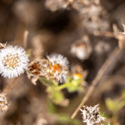
Hazard Peak Trail Photos


You might also consider
More like Hazard Peak Trail
Recommended Reviews - Hazard Peak Trail
Start your review...

9 years ago
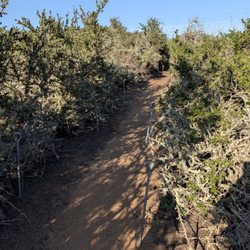
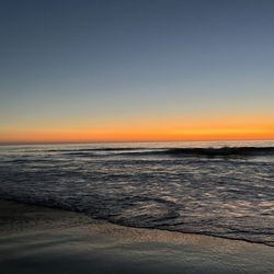
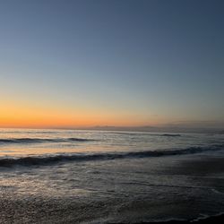
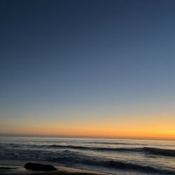
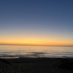
On my second visit to Montana de Oro park, I wanted to try a different trail (having focused on the Bluff Trail last time.) Having read up on Hazard Peak, it seemed like a great option to get outdoors and burn some calories, post Thanksgiving feasting. The trailhead is easy to find-just drive a mile or so past the park entrance and you will see the day use lot on the right hand side (just before the Spooner's Cove turn off-if you hit that lot, you've gone too far.) Cross the road and head up the single track trail which is 3 miles up, one way, to the peak. It's well travelled by mountain bikers but most of the cyclists we met were going up hill, not down and were very polite and respectful. While you are going uphill the entire first half, the incline is slight and not too steep. The trail is 90% open so wear sunscreen or a hat and take care on hotter days. In November, though, it was crisp and breezy-just the right temperature. Pretty narrow in spots and mainly you are hiking through low coastal scrub. There is one section that takes you through a pretty eucalyptus grove, which is a nice break from the sun. The views make this hike totally worthwhile-you get sweeping scenery of the coast, Morro Rock and the interior valleys and hills of Montana de Oro. At the peak there is a bench where you can soak it all in and take lots of pics. Head back down the trail the way you came to round out your six mile journey. There is a trail that continues after the peak which I believe will take you on a 9 mile loop, but I had other activities planned for the day, so opted to head back. The 6 miles took us about 2 hours and 15 minutes which included photo op stops. Decent workout and totally moderate if you're in good shape. read more


11 years ago
This path is beautiful, however I wasn't prepared for this trail. Starting off on a low grade then inclines quickly. Several times I had to dismount my bike and hike it up. I was able to get to one of the summits then made my way back. The descend was quick, which was nice. Tip: make sure your brakes are in proper order and make some noise when going around corners and as always sunblock is a must! Overall I'll be doing this path again. read more


More info about Hazard Peak Trail
Hazard Peak Trl
Los Osos, CA 93402
Directions
Hours
Outdoor Amenities
You might also consider


Hazard Peak Trail - hiking - Updated May 2026
Best of Los Osos
People found Hazard Peak Trail by searching for…
Mountain Bike Trails in Los Osos, California
Beaches in Los Osos, California
Things to Do in Los Osos, California
Easy Hikes in Los Osos, California
Off Road Trails in Los Osos, California
Bicycle Shop in Los Osos, California
Bike Paths in Los Osos, California
Walking Trails in Los Osos, California
Must See in Los Osos, California
Pump Track in Los Osos, California
Scenic View in Los Osos, California
Scenic Overlook in Los Osos, California
Running Trails in Los Osos, California
Things to Do at Night in Los Osos, California
Beautiful Views in Los Osos, California
Dog Hiking Trails in Los Osos, California
Waterfall in Los Osos, California
Sightseeing in Los Osos, California
Shaded Hike in Los Osos, California
Trending Searches in Los Osos, CA
Bird Sanctuary near Hazard Peak Trail
Botanical Gardens near Hazard Peak Trail
Bounce House Rentals near Hazard Peak Trail
Campgrounds near Hazard Peak Trail
Cherry Picking near Hazard Peak Trail
Cliff Jumping near Hazard Peak Trail
Floral Designers near Hazard Peak Trail
Flower Fields near Hazard Peak Trail
Flower Shop near Hazard Peak Trail
Garage Sales near Hazard Peak Trail
Garden Center near Hazard Peak Trail
Mens Suits near Hazard Peak Trail
Mountain Bike Trails near Hazard Peak Trail
Nurseries & Gardening near Hazard Peak Trail
Outdoor Activities near Hazard Peak Trail
Outdoor Furniture Stores near Hazard Peak Trail
Party Equipment Rentals near Hazard Peak Trail
Pedicure near Hazard Peak Trail
Photo Spots near Hazard Peak Trail
Picnic Areas near Hazard Peak Trail
Places To Take Pictures near Hazard Peak Trail
Plant Nursery near Hazard Peak Trail
Rock Quarry near Hazard Peak Trail
Running Trails near Hazard Peak Trail
Scenic Drive near Hazard Peak Trail
Scenic Night View near Hazard Peak Trail
Secluded Spots near Hazard Peak Trail
Star Gazing near Hazard Peak Trail
Sunrise View near Hazard Peak Trail
Swimming Holes near Hazard Peak Trail
Table And Chair Rentals near Hazard Peak Trail
Browse Nearby
BEST of Los Osos, California Restaurants near Hazard Peak Trail
BEST of Los Osos, California Things to Do near Hazard Peak Trail
BEST of Los Osos, California Coffee near Hazard Peak Trail
BEST of Los Osos, California Beaches near Hazard Peak Trail
BEST of Los Osos, California Breakfast near Hazard Peak Trail
BEST of Los Osos, California Campgrounds near Hazard Peak Trail
Browse Brands
Related Searches in Los Osos, CA
Affordable Bike Repair Services in Los Osos, California
Affordable Bike Tune Up Services in Los Osos, California
Affordable Kayak Rental Services in Los Osos, California
Affordable Tandem Bike Rental in Los Osos, California
Best Dirt Bike Riding Spots in Los Osos, California
Best Electric Bike Rental Services in Los Osos, California
Best Fishing Locations and Guides in Los Osos, California
Best Places for Horseback Riding in Los Osos, California
Best Places for Stunning Views in Los Osos, California
Best Used Bikes for Sale Near Los Osos, California
Check Out Off Road Trails in Los Osos, California
Discover Dog Friendly Trails to Explore in Los Osos, California
Discover Popular Bike Tours in Los Osos, California
Discover Popular Bike Trails in Los Osos, California
Discover Scenic Bike Paths in Los Osos, California
Discover Scenic Mountain Bike Trails Near Los Osos, California
Discover Scenic Waterfall Spots in Los Osos, California
Discover Top State Parks to Visit in Los Osos, California
Discover a Hiking Trail in Los Osos, California
Discover the Best Night Hike Trails in Los Osos, California
Dog-Friendly Hikes With Dogs in Los Osos, California
Enjoy Biking Adventures Around Los Osos, California
Enjoy Camping Adventures Around Los Osos, California
Enjoy Exciting Mountain Biking Adventures in Los Osos, California
Enjoy Hiking Adventures in Los Osos, California
Enjoy Kayaking Adventures in Los Osos, California
Enjoy Scenic Night View Experiences in Los Osos, California
Enjoy Tent Camping Spots Around Los Osos, California
Enjoy a Beautiful Waterfall Hike in Los Osos, California
Enjoy a Scenic Walk in Los Osos, California, {State}
Enjoy the Best Picnic Spots and Ideas in Los Osos, California
Enjoy the Best Tubing Experiences in Los Osos, California
Enjoy the Best Walking Trails in Los Osos, California
Explore Beautiful Parks and Green Spaces in Los Osos, California
Explore Bike Rentals Throughout Los Osos, California
Explore Easy Hikes Perfect for All in Los Osos, California
Explore Electric Bikes Available in Los Osos, California
Explore Fun Activities to Do in Los Osos, California
Explore Nature Spots Around Los Osos, California
Explore Popular Campgrounds Near Los Osos, California
Explore Popular Scenic Overlook Points in Los Osos, California
Explore Popular View Points Around Los Osos, California
Explore Scenic Lakes to Visit in Los Osos, California
Explore Secret Spots Worth Visiting in Los Osos, California
Explore Top Dog Parks in Los Osos, California Near You
Explore the Best Beach Spots in Los Osos, California
Explore the Best Boating Spots in Los Osos, California
Explore the Best Trail Options in Los Osos, California