Point Buchon Trail Photos


You might also consider
More like Point Buchon Trail
Recommended Reviews - Point Buchon Trail
Start your review...

Reviews With Photos - Point Buchon Trail

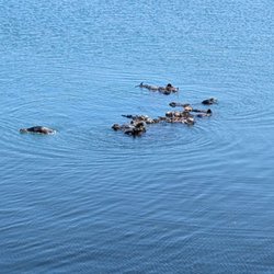
I went mid-March and it was a great time. You see whales spouting and the poppies are popping with I'm sure more to come. Pretty easy, very peaceful. Beautiful rock formations and beaches to admire from above. It is much less traveled than the Bluff hike. You have to check in and out and a max of 275 ppl a day any day that it is open. Especially if you've done the Bluff Trail, this is a nice change and also starts from the same parking lot as Bluff trial (just to the left of the lot to start ascent up to the check-in station.

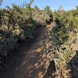
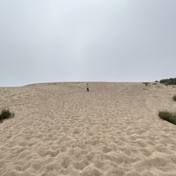
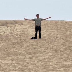
One of the best casual trails in SLO. To access this trail you must enter Montana de Oro state park and keep driving down Pecho Valley Road until you hit the end parking lot. Walk toward the property line of PG&E (metal gate) and continue up the private road to the guard station. Because this on PG&E property it's not freely open to the public. You have to pass a security gate and go to a sign in at the guard station. This trail is NOT open on TUESDAY and THURSDAY, and under some weather conditions. It also closes at 4 or 5 PM depending on the season. The Point Buchon Trail is a great walk along the coast on a well maintained trail. There are many exploring options here including going down to a private beach (with a sea cave), a sinkhole, and several viewpoints of coastal rock formations. It's 7 miles to do the whole down-the-coast and back, or 2 something miles to just hit the beach, the sinkhole, the first viewpoint, and take the shortcut back.. - During spring ( Late February through April) this place is loaded with yellow flowers and poppies. - They lock the gate promptly at close time. - If you do walk down to the beach the sand is very tough to walk on. Sandals wont work very well because the tiny pebbles will get in your shoe. - Not as busy as the other trails in this area. I'm guessing the large security gate scares most people away. - Limited to 275 people a day. - If you time it right, there are some cool tide pools right next to the Sea Cave. Tip - If for some reason the trail is closed ( or has exceeded the daily limit), there are other trailheads from this parking lot (Bluff Trail and the Coon trail)..

*This trail is NOT a part of the Montana De Oro State Park* This trail is called Point Buchon Trail. The land is owned by PG&E, but last year they've opened up the land to the public for hiking. When you drive all the way through the Montana De Oro State Park to the end, there is a parking lot. From there you see a gate and a sign "Trail Open" and trail hours (see picture). Walk through the gate about 1/4 mile and there is a "check in" station manned by 2 guys, who'd ask you to sign a waiver to enter the trail. Well let me tell you, it is well worth the trouble of signing the waiver and all that. The view from the trail is very beautiful, and trail is well marked (over marked I would say) and well taken care of. There are some roped areas where could be dangerous (i.e. sink hole), some edge of the cliffs are eroding but use your common sense not to cross the rope and stand on the edge of the cliff to look into the ocean or to take pictures.... jeez... The whole trail is about 3.8 miles, in and out. (1) Short way --Go to the Coon Creek Beach - Point Buchon Lookout- then take the shortcut and come back to the trail entrance. (2) Longer way --You can go to the Coon Creek Beach - Point Buchon Lookout - Disney Point Lookout - last Lookout and turn back. * please see the picture of the trail map My fiance and I were at a gallery in downtown Morro Bay and one of the photographer who was showing a picture taken at this trail at the gallery told us how to get here. Trail is very quiet, could be foggy and windy/chilly but we were very glad to find this trail. Hope PG&E will keep this trail open for public.

BEST hike I've done in a while, and I hiked some Portland waterfalls last year, and have hiked some Bay Area trails from time to time. Point Buchon Trail might be a bit confusing to get to, but it's basically a PG&E-owned trail in the Montana de Oro State Park, which is owned by California. To get there, you'll drive into the state park on windy roads for about a solid 20 minutes before reaching the end, which is the last parking lot next to a chain-linked fence. Along the way you'll pass a beautiful Eucalyptus tree area that makes a sort of tunnel-like overhead while you drive (roll down the windows!) as well as lots of beautiful viewpoints and some mountainous houses. Keep going all the way until you don't have any road left to drive. Because this trail is PG&E owned, you abide by their rules and the safety regulations they've put out to ensure no lawsuits! You'll have to sign in and sign out of their logbook, but in the process you can learn a bit about the trail itself and the wildlife with the representative. We had a very friendly mustach'd man who informed us that the whale-like-monotonous wail we heard in the distance was the sound the buoy makes to alert fishermen that this area was off limits! HOW COOL. The trail itself took 2.5 hours for us round trip, 1.5 hours on way and 1 on the way back because we took excessive photos of everything on the way there. We hiked through sandy parts, pebbly/rocky turf, and were surprised to encounter a lot of runners who were ambitious enough to run the whole thing. It's not an intense hike, meaning that there aren't a lot of elevation changes, but it is quite narrow in some parts so be prepared for that. There is a portable restroom stop along the way if you're desperate to use the toilets, but I would recommend using it at the parking area so you won't feel unsanitary throughout the hike. Weather in late June was superb, as inland in SLO it reached 80's-90F, but by the time we got close to the Pacific for this hike, it remained a cool and not so foggy 70! Great weather in the summer, and so many elements to document with your phone or just take in. I loved this hike and applaud PG&E for preserving this area through community education and all of the trail markings along the way. Absolutely wonderful! I can't wait to hike this again in the future, and even bring my kids here in the far far future. I think everyone should hike this whether you're doing a Highway 1 road trip or passing through Paso Robles or SLO!

Looking for a beautiful coastal trail? Well look no further! It's a relatively flat trail at the end of MDO and the views are incredible! I would advise going on a week day and going early- I went on a Thursday when they first opened and had the trail all to myself. Also, make sure to check the hours before driving out there because they aren't open everyday and have limited hours when they are open.

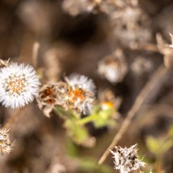
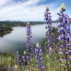
It's quite lovely to go when the wildflowers were at their peak. Get ready for a jaunt through: * Grassy expanses where cattle roam free * Windswept hills -- hold onto your hat! * Curious and completely otherworldly coastal rock formations Thank you, PG&E, for opening up this wild private space for public enjoyment!

So glad I found this place. The last stop basically at Montana de Oro so you can't miss it. I only went halfway because I spent a good amount at coon creek beach which was gorgeous! It's flat pretty much the entire way so you get a great deal of steps in and awesome views. On a clear day you can see everything and there were a lot of birds out.

Hard to believe a few others claim there wasn't much to see. Panoramic views, ground erosion such as sink holes and arches beneath the ground's surface make for just part of this ultra scenic place. It's a landscape photographers' heaven as far as coastal view points go. I've been to the 12 apostles in southern Australia outside of Melbourne and this is equally as jaw dropping (search this online and you'll see what I'm referring too). We visited this trail a week ago and I'm unable to stop thinking about our journey. The wind can be intense as well as the ultra violet rays. We were fooled by gray cloud cover and when we returned our faces were red for several days. The glare of the ocean and sky can be a bit much, sunglasses and sun screen recommended. I've posted 7 photos at my flick account which is here: https://www.flickr.com/photos/revup67/14234648990/in/photostream/

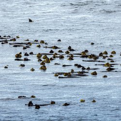
This trail is managed by PG&E as it abuts the Diablo Canyon nuclear power plant, so there is a check-in/out procedure and the trail is not open all the time. However, my wife and I hike this trail every year when we celebrate our anniversary (in October) or our birthdays (in November) nearby and love the return to it. This year we only went as far as Lookout Point before we had to turn back due to a reservation elsewhere (a kayak tour of Morro Bay). But we usually hike all the way to the end. Spectacular views of the coast and the rock formations jutting out into the ocean. Birds galore on the rocks and often seals in the water. Sometimes we have spotted whales far offshore. PG&E maintains the trails nicely and the walk is easy, though several miles long to the end. Along with the many hiking trails in next-door Montana de Oro, this is not to be missed by any hiking enthusiast on the central cost. read more


2 years ago
Wow. This might be one of my favorite trails I've ever hiked in my life. My cousin and I recently re-visited the Montana De Oro State Park area. Last time, we had hiked Valenica, Oates, and Hazard Peaks, which you can read about here: http://tinyurl.com/8mjdzhha This time, we wanted to hike Point Buchon Trail through Diablo Canyon, which only accepts a limited number of hiking reservations per day. Luckily, we made it on time, and were able to register in person at the kiosk on the trail. (Technically, Point Buchon trail is owned and operated by PG&E, and is not a part of Montana De Oro State Park, but the road is the same, and the parking areas are right next to each other.) My cousin had mentioned some "cool rocks," but that barely even begins to describe what we saw here. There were spectacular geological formations around every single bend in the trail. The views were indescribable. I've never seen anything like this in my life, even though I am originally from Southern California. Most of the "cool rocks" are the remnants of eroded coastlines (the ruins of ancient beaches). There are numerous arches and caves, and even a sinkhole. Watching the waves come in through the sinkhole was one of the most interesting things we saw that day. We had originally planned to go down into some of the caves, but the tide was way too high for that. In fact, the tide was the highest I've ever seen in my life. Once we were nearing the end of the trail, from up on the cliffs near the power plant, we saw some waves that we estimated to be about thirty feet high. Down on the beach, back on the calmer side of the trail, we found all kinds of tide pools and tiny shells. While I was busy taking pictures of sea snails inside of pink abalone shells, my cousin was jumping rope with a giant piece of bull kelp. My cousin said we hiked eight miles, but I swear it only felt like one. Time flies. This trail was pretty easy to hike, but for an added challenge, it would be easy to add on any of the nearby three peaks in Montana De Oro. Point Buchon Trail is a must-see. If you haven't been here yet, I highly recommend checking it out at least once! read more


Wow! The views along this trail are incredible! Nothing compares to certain sections of the California coast line and the only way to see these views are along this trail. The hike is 6.6 miles round trip on mostly flat land so it's an easy walk that can be enjoyed by everyone. The trail has a few different stopping points along the way, many benches throughout at various lookout spots, and even a restroom at the best spot to stop and turn around. The trail technically goes 4 miles out but the last .7 of a mile is not really worth hiking; there isn't much of a view and nothing interesting beyond the lookout where the restroom is located. If I hike this trail again I will most likely stop where the restroom is instead of the turn around point at the very end. The views are worth coming to this trail for a nice easy hike. This is PG&E land and the trail is very well maintained and marked throughout the entire length. Very clean with informational signs all along the well marked path read more

2 years ago
I went mid-March and it was a great time. You see whales spouting and the poppies are popping with I'm sure more to come. Pretty easy, very peaceful. Beautiful rock formations and beaches to admire from above. It is much less traveled than the Bluff hike. You have to check in and out and a max of 275 ppl a day any day that it is open. Especially if you've done the Bluff Trail, this is a nice change and also starts from the same parking lot as Bluff trial (just to the left of the lot to start ascent up to the check-in station. read more


One of the best casual trails in SLO. To access this trail you must enter Montana de Oro state park and keep driving down Pecho Valley Road until you hit the end parking lot. Walk toward the property line of PG&E (metal gate) and continue up the private road to the guard station. Because this on PG&E property it's not freely open to the public. You have to pass a security gate and go to a sign in at the guard station. This trail is NOT open on TUESDAY and THURSDAY, and under some weather conditions. It also closes at 4 or 5 PM depending on the season. The Point Buchon Trail is a great walk along the coast on a well maintained trail. There are many exploring options here including going down to a private beach (with a sea cave), a sinkhole, and several viewpoints of coastal rock formations. It's 7 miles to do the whole down-the-coast and back, or 2 something miles to just hit the beach, the sinkhole, the first viewpoint, and take the shortcut back.. - During spring ( Late February through April) this place is loaded with yellow flowers and poppies. - They lock the gate promptly at close time. - If you do walk down to the beach the sand is very tough to walk on. Sandals wont work very well because the tiny pebbles will get in your shoe. - Not as busy as the other trails in this area. I'm guessing the large security gate scares most people away. - Limited to 275 people a day. - If you time it right, there are some cool tide pools right next to the Sea Cave. Tip - If for some reason the trail is closed ( or has exceeded the daily limit), there are other trailheads from this parking lot (Bluff Trail and the Coon trail).. read more


*This trail is NOT a part of the Montana De Oro State Park* This trail is called Point Buchon Trail. The land is owned by PG&E, but last year they've opened up the land to the public for hiking. When you drive all the way through the Montana De Oro State Park to the end, there is a parking lot. From there you see a gate and a sign "Trail Open" and trail hours (see picture). Walk through the gate about 1/4 mile and there is a "check in" station manned by 2 guys, who'd ask you to sign a waiver to enter the trail. Well let me tell you, it is well worth the trouble of signing the waiver and all that. The view from the trail is very beautiful, and trail is well marked (over marked I would say) and well taken care of. There are some roped areas where could be dangerous (i.e. sink hole), some edge of the cliffs are eroding but use your common sense not to cross the rope and stand on the edge of the cliff to look into the ocean or to take pictures.... jeez... The whole trail is about 3.8 miles, in and out. (1) Short way --Go to the Coon Creek Beach - Point Buchon Lookout- then take the shortcut and come back to the trail entrance. (2) Longer way --You can go to the Coon Creek Beach - Point Buchon Lookout - Disney Point Lookout - last Lookout and turn back. * please see the picture of the trail map My fiance and I were at a gallery in downtown Morro Bay and one of the photographer who was showing a picture taken at this trail at the gallery told us how to get here. Trail is very quiet, could be foggy and windy/chilly but we were very glad to find this trail. Hope PG&E will keep this trail open for public. read more


BEST hike I've done in a while, and I hiked some Portland waterfalls last year, and have hiked some Bay Area trails from time to time. Point Buchon Trail might be a bit confusing to get to, but it's basically a PG&E-owned trail in the Montana de Oro State Park, which is owned by California. To get there, you'll drive into the state park on windy roads for about a solid 20 minutes before reaching the end, which is the last parking lot next to a chain-linked fence. Along the way you'll pass a beautiful Eucalyptus tree area that makes a sort of tunnel-like overhead while you drive (roll down the windows!) as well as lots of beautiful viewpoints and some mountainous houses. Keep going all the way until you don't have any road left to drive. Because this trail is PG&E owned, you abide by their rules and the safety regulations they've put out to ensure no lawsuits! You'll have to sign in and sign out of their logbook, but in the process you can learn a bit about the trail itself and the wildlife with the representative. We had a very friendly mustach'd man who informed us that the whale-like-monotonous wail we heard in the distance was the sound the buoy makes to alert fishermen that this area was off limits! HOW COOL. The trail itself took 2.5 hours for us round trip, 1.5 hours on way and 1 on the way back because we took excessive photos of everything on the way there. We hiked through sandy parts, pebbly/rocky turf, and were surprised to encounter a lot of runners who were ambitious enough to run the whole thing. It's not an intense hike, meaning that there aren't a lot of elevation changes, but it is quite narrow in some parts so be prepared for that. There is a portable restroom stop along the way if you're desperate to use the toilets, but I would recommend using it at the parking area so you won't feel unsanitary throughout the hike. Weather in late June was superb, as inland in SLO it reached 80's-90F, but by the time we got close to the Pacific for this hike, it remained a cool and not so foggy 70! Great weather in the summer, and so many elements to document with your phone or just take in. I loved this hike and applaud PG&E for preserving this area through community education and all of the trail markings along the way. Absolutely wonderful! I can't wait to hike this again in the future, and even bring my kids here in the far far future. I think everyone should hike this whether you're doing a Highway 1 road trip or passing through Paso Robles or SLO! read more


Looking for a beautiful coastal trail? Well look no further! It's a relatively flat trail at the end of MDO and the views are incredible! I would advise going on a week day and going early- I went on a Thursday when they first opened and had the trail all to myself. Also, make sure to check the hours before driving out there because they aren't open everyday and have limited hours when they are open. read more


14 years ago
It's quite lovely to go when the wildflowers were at their peak. Get ready for a jaunt through: * Grassy expanses where cattle roam free * Windswept hills -- hold onto your hat! * Curious and completely otherworldly coastal rock formations Thank you, PG&E, for opening up this wild private space for public enjoyment! read more


9 years ago
So glad I found this place. The last stop basically at Montana de Oro so you can't miss it. I only went halfway because I spent a good amount at coon creek beach which was gorgeous! It's flat pretty much the entire way so you get a great deal of steps in and awesome views. On a clear day you can see everything and there were a lot of birds out. read more


12 years ago
Hard to believe a few others claim there wasn't much to see. Panoramic views, ground erosion such as sink holes and arches beneath the ground's surface make for just part of this ultra scenic place. It's a landscape photographers' heaven as far as coastal view points go. I've been to the 12 apostles in southern Australia outside of Melbourne and this is equally as jaw dropping (search this online and you'll see what I'm referring too). We visited this trail a week ago and I'm unable to stop thinking about our journey. The wind can be intense as well as the ultra violet rays. We were fooled by gray cloud cover and when we returned our faces were red for several days. The glare of the ocean and sky can be a bit much, sunglasses and sun screen recommended. I've posted 7 photos at my flick account which is here: https://www.flickr.com/photos/revup67/14234648990/in/photostream/ read more


17 years ago
Hello To all the People who Can't read the NO TRESPASSING SIGNS on the fence between the state park and coon creek beach. The only way you can have access to the beach is to come through the gate and fill out a waiver. The trail is open Thursday Thu Monday 8 am to 3:45. If people continue to trespass they will start to prosecute. and nobody wants that... read more


18 years ago
9 years ago
9 years ago
10 years ago
13 years ago
17 years ago
More info about Point Buchon Trail
End Of Pecho Valley Rd
Los Osos, CA 93402
Directions
Hours
Outdoor Amenities
Ask the Community - Point Buchon Trail
Review Highlights - Point Buchon Trail
You might also consider


Point Buchon Trail - hiking - Updated July 2026
Best of Los Osos
People found Point Buchon Trail by searching for…
Beaches in Los Osos, California
Tide Pools in Los Osos, California
Things to Do in Los Osos, California
Fishing in Los Osos, California
Places to Take Pictures in Los Osos, California
Running Trails in Los Osos, California
Scenic Drive in Los Osos, California
Off Road Trails in Los Osos, California
Walking Trails in Los Osos, California
Easy Hikes in Los Osos, California
Waterfalls in Los Osos, California
Scenic View in Los Osos, California
View Points in Los Osos, California
Hiking With Kids in Los Osos, California
Lookout Points in Los Osos, California
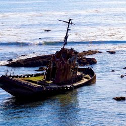
Abandoned Buildings in Los Osos, California
Night Hike in Los Osos, California
Things to Do on a Rainy Day in Los Osos, California
Bridge in Los Osos, California
Trending Searches in Los Osos, CA
4th Of July Fireworks near Point Buchon Trail
Boat Rental near Point Buchon Trail
Cliff Jumping near Point Buchon Trail
Day Trips near Point Buchon Trail
Fireworks near Point Buchon Trail
Jet Ski Rental near Point Buchon Trail
Kayak Rental near Point Buchon Trail
Off Road Trails near Point Buchon Trail
Outdoor Activities near Point Buchon Trail
Public Pools near Point Buchon Trail
Public Shower near Point Buchon Trail
River Swimming near Point Buchon Trail
Rock Quarry near Point Buchon Trail
Scenic Night View near Point Buchon Trail
Scenic Overlook near Point Buchon Trail
Secluded Spots near Point Buchon Trail
Soccer Store near Point Buchon Trail
Splash Pad near Point Buchon Trail
Strawberry Picking near Point Buchon Trail
Sunrise View near Point Buchon Trail
Swimming Holes near Point Buchon Trail
Swimming Lakes near Point Buchon Trail
U Pick Farms near Point Buchon Trail
Browse Articles
Browse Nearby
BEST of Los Osos, California Restaurants near Point Buchon Trail
BEST of Los Osos, California Coffee near Point Buchon Trail
BEST of Los Osos, California Things to Do near Point Buchon Trail
BEST of Los Osos, California Beaches near Point Buchon Trail
BEST of Los Osos, California Breakfast near Point Buchon Trail
BEST of Los Osos, California Shopping near Point Buchon Trail
BEST of Los Osos, California Campgrounds near Point Buchon Trail
Browse Brands
Related Searches in Los Osos, CA
Affordable Kayak Rental Services in Los Osos, California
Best Fishing Locations and Guides in Los Osos, California
Best Places for Horseback Riding in Los Osos, California
Best Places for Stunning Views in Los Osos, California
Check Out Off Road Trails in Los Osos, California
Discover Dog Friendly Trails to Explore in Los Osos, California
Discover Scenic Mountain Bike Trails Near Los Osos, California
Discover Scenic Waterfall Spots in Los Osos, California
Discover Top State Parks to Visit in Los Osos, California
Discover a Hiking Trail in Los Osos, California
Discover the Best Night Hike Trails in Los Osos, California
Dog-Friendly Hikes With Dogs in Los Osos, California
Enjoy Camping Adventures Around Los Osos, California
Enjoy Exciting Mountain Biking Adventures in Los Osos, California
Enjoy Kayaking Adventures in Los Osos, California
Enjoy Tent Camping Spots Around Los Osos, California
Enjoy a Beautiful Waterfall Hike in Los Osos, California
Enjoy the Best Picnic Spots and Ideas in Los Osos, California
Enjoy the Best Walking Trails in Los Osos, California
Explore Beautiful Parks and Green Spaces in Los Osos, California
Explore Easy Hikes Perfect for All in Los Osos, California
Explore Fun Activities to Do in Los Osos, California
Explore Popular Campgrounds Near Los Osos, California
Explore Top Dog Parks in Los Osos, California Near You
Explore the Best Beach Spots in Los Osos, California
Explore the Best Boating Spots in Los Osos, California
Explore the Best Trail Options in Los Osos, California
Family Friendly Hiking With Kids in Los Osos, California
Find Beautiful Views in Los Osos, California
Find Popular Ziplining Spots Around Los Osos, California
Find the Best Parks for Picnics in Los Osos, California
Find the Best Playgrounds to Visit in Los Osos, California
Find the Best Scenic View Locations in Los Osos, California
Great Places to Walk in Los Osos, California
Hiking Trails With Waterfalls in Los Osos, California
Off Leash Dog Hiking Trails in Los Osos, California
Plan a Scenic Drive Route Near Los Osos, California
Popular Outdoor Activities to Try in Los Osos, California
Popular Picnic Spots to Visit in Los Osos, California
Popular Things to Do in Los Osos, California
Safe River Swimming Areas in Los Osos, California
Safe and Fun Parks for Kids in Los Osos, California
Top Paddleboarding Activities in Los Osos, California
Top Places for Snorkeling in Los Osos, California
Top Playgrounds for Kids to Enjoy in Los Osos, California
Top Running Trails to Explore in Los Osos, California
Top Swimming Lakes to Enjoy in Los Osos, California
Top Swimming Spots and Pools in Los Osos, California