Valencia Peak Trail Hiking Photos


You might also consider
More like Valencia Peak Trail
Recommended Reviews - Valencia Peak Trail
Start your review...

Reviews With Photos

What a beautiful place to hike. There are many trails in the area for all levels but we chose this one today. We did an early sunrise hike and only ran into 1 jogger on our way up...coming down around 9:00ish, there were plenty of hikers on their way up (in case you're a lone hiker and concerned about safety). The views are spectacular...just green landscape and blue ocean all the way. The hike is quite easy 75% of the time, but when you are nearing the peak, it gets a little harder as it's a contant steeper incline, but you can do it! When you're almost at the peak, there's 2 ways to get there. The trail to your left is shorter but much steeper. If that makes your heart skip a beat, go straight pass the sign and it'll be an easier walk up... I came here on 1/24/21 when the weather was in the 40s and 50s. If you get cold easily (like me), I highly recommend layering. Depending on the side you're on, sun no sun and the wind, I would go from warm to cold often and when I reached the peak I was freezing despite my thermal shirt, flannel jacket, wind breaker, and gloves....there is a picnic table at the top so you can enjoy a meal with spectacular views. Usually the hike down is the easy part, but I found it more challenging because of all the loose rocks (there's plenty). We had hiking shoes and we still slid, had multiple near falls and twisted ankles so be careful. The trail said it was 2.1 miles up (4.2 round-trip)...don't know how they measure it (straight line maybe), but my Fitbit said I did 6 miles...and felt more like 6 then 4....

This is my absolute favorite hike! The view at the top is just so amazing everywhere you look. Even when you aren't at the top you basically get the coastal view the entire way up. I can never get tired of it, even though hiking up can be a bit tiring lol. The hike itself is relatively easy. I can usually go up without taking any breaks and it probably takes me 45 minutes. However, if you haven't been on a hike in awhile I'd recommend expecting the hike up to take an hour. I've done this hike during sunrise and sunset and the views are just phenomenal both times of the day. I wouldn't hike on a cloudy day though because the peak might be in the clouds and you won't get any visibility.

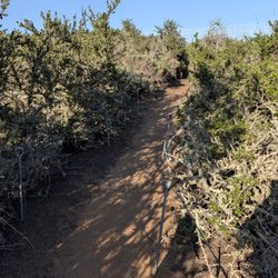
Great work out hike if you're in the Montana de Oro area on the central coast. It is roughly a 1350 ft climb from almost sea level up to an impressive peak. It took me about an hour up and maybe 45 minutes down, so it was the perfect morning work out that left plenty left for the rest of the day. I highly recommend going in the morning, as early as you're able to. The lighting is spectacular, assuming it isn't covered in fog, which is actually pretty often out this way. I got super lucky as the day I trekked it was crystal clear and the very next day, thick cloud cover that I couldn't see the hill from the bottom. The mornings also have less traffic, and it is a narrow trail. At 8ish in the morning, I only ran into 2 bodies on the way up. On my way down I ran into a dozen. So it increases quickly. I'm going to divide the hike up in thirds. The first leg is super mellow. A very gradual grade through a narrow dirt trail in very heavy rough brush. I went in the spring, so I was amongst a strong presence of these tiny rabbits/bunnies. I must of saw at least 2 dozen crossing these dirt trails. They are pretty shy and usually go back into the brush, but a few will linger around. The second stretch, the trail gets a bit steeper but still not strenuous. The trail also starts to get rockier, as you can hear more of a crunch under your steps. The views start to get a little more impressive as the ocean starts to be the main view and it is nice to see the trail behind you as you are ascending. The third stretch is where the work out is. This is steeper and almost all rock. The rocks are loose also so you have to watch your step, especially on the way down. It does give way and slip, trust me. The closer you get to the peak, the steeper. Some spots are like a staircase made of rock. Push along cuz the peak is close and the reward is great. The peak is completely exposed, so it is breezy and if sunny completely blazing. If you look to the east, you'll see an awesome view with green hills as far as the eye can see. Look to the west and you'll be face to face with the ocean and Morro Bay off to the right. Great phone reception up here also which was a surprise, so I sent photos to friends whilst they were at work haha. So great climb in that it starts nice and mellow so you can establish a warm up. It then gets progressively more sweat inducing with a great reward at the end where you'll only invest a couple of hours of your time. There are few other trails that link up to Valencia Peak trail, like the longer Oates Trail. The signage is clear, so it is easy to pick. Most people take the Valencia because I'm sure the ocean views are more up front. Highly recommend!

One of the best trails I've done in a while. Its a fresh breath of air doing a trail by the coast where you can hear the sound of the waves and the view of the ocean the entire trail compared to mountain hikes like Yosemite there's none of that. The trailhead is just after you pass the visitors center, across from the Bluff Trail trailhead. There is a nice signage there. Parking space is limited , most people park on the street. It was already crowded by 9 am on Sunday. Distance is 4.6 miles and the elevation gain is 1,340 ft . Some area are pretty steep and very rocky. Definitely should wear a pair of hiking boots or shoes with good traction. Trekking poles might come in handy. 3/25/2018 it was super windy and pretty cool. I had a windbreaker and gloves which helped. The view from the top is absolute amazing. You can see Morro Rock , Morro Bay , Cayucus , Avila Beach... blue sky , blue water , green hills and wild flowers. So worth it. I'd classify this trail as moderate because of the elevation gain and steepness. Might be hard for beginners but totally doable.

Amazing 4.4 miles. What an amazing views. It was a moderate hike but the view was great. Very easy to find, Google Maps is right on point. If you get there early parking is easy. We started at 730AM, by the time we came down parking was tight. Also their are several hiking trails along the road.

What views. About a 2 mile hike up to the top. Very steep hike so be careful and wear a jacket. Lots of breeze as you get higher to the top. There's also a lot of loose rocks so watch your footing. Once we got to the peak we were surrounded by clouds. It kind of obstructed the view a bit that day. You can get a good view of the entire coastline once you're up there.


Went out in a limb and decided to take a hike at Valencia. There are options to branch out but I stuck strictly with Valencia. This trail is good if you want a work out and views above fog level - which is a pretty cool thing to say - that you "were above the clouds!" If you have bad knees, be aware there are several steep rocky inclines and the paths get pretty narrow and close the edge of the hills. I spent a lot of time looking down to ensure I didn't lose my footing. There's a lot of poison oak and there are warnings of ticks and mountain lions (I saw none). Once you think you're almost to the top, you're not. To get to the summit you endure winding paths. Be careful if you go solo, if you fall you might not be discovered or get help since there's not a lot of traffic even though it's described as moderately trafficked. I started at 2:30 and finished round trip by 5:30. I did see a couple people pass me. Take a camelback, snack and plenty of water. The steep trail will get your heart rate up if you're new to hiking, the protein will help you manage your energy and balance on the way back down. Your buns of steel, beer, vodka, or whatever you drank the night before (I see you slo county/cal poly!) wont make this trail any easier and you'll be hurtin! This trail is probably a good "first date" trail. Lots of photo opportunities too. Giving this 4/5 stars. Great hike, summit offers 360 views of Los Osos trails, but you don't necessarily have to go all the way to the top for amazing views. Wear layers - between the sun, rolling fog and coastal breeze the temperature can fluctuate quite a bit. Happy hiking!

Whether you're a beginner or experience hiker, Valencia peak trial will spark your interest. Valencia peak trail is a well maintained trail with gorgeous panoramic views of Los Osos coastline (including Morro Bay) and the Montana De Oro mountain ridge. At first that trail starts off easy then progress to a medium hike. A few tips: Exercise caution in certain spots due to loose terrain. Keep a look out for the U.S. Coast & Geodetic Survey Marker located on the peak, and Sunscreen is a MUST.

Definitely one of the best hikes I've ever been on. We started extremely early so by the time we got to the peak, all we could see were those early morning overcast clouds. It really gave us that feeling of being at the top of the world. I would recommend to anybody, especially if you are camping at the Montana De Oro State Park. Be sure to bring plenty of water and wear sunscreen (little shade). Also, there are some rocky/loose gravelly parts after the halfway point so wear proper shoes for safety.


I'm a tenderfoot when it comes to hiking. I don't do it for the exercise (although that's a nice side effect of walking up a small mountain). I do it to see something new, interesting and cool; I like the reward of a nice view of something at the end of the journey. I realize that's probably the outdoorsman equivalent of saying I only listen to Top 40 songs. In that vein Valencia Peak is like a new LMFAO song about party rocking bundled with a trip to Mars in a purple rocket with stripper poles. I have no idea what any of that means but that's what I said to my friend and I stick by it. Standing at the trailhead along Pecho Valley Road across from the very popular Bluff Trail, my eyes are being overstimulated and I'm still standing next to my car adjusting my selfie stick. Ultramarine blue water crashes into the bluffs on either side of the sandy cove just below me. The weather is breezy and chilly even at noon and few people are on the beach. A small dog runs along the wet sand playing chicken with each incoming wave, its yapping carried up to where I'm standing by the steady onshore wind. As a person accustomed to SoCal hikes that start, continue and end in some kind of dry, brushy desert canyon full of lizards and horse manure, the multitude of the sights and sounds of the Central Coast briefly pop my Orange County bubble of track homes and Chipotles to show me a small peek of what Nature actually is like without a weekly groundskeeper. Like a well-paced story, each of the three or four sections of the four mile round-trip hike has its own moods and impressions. A long ridge during the second half of the hike up has you looking down at deep canyons to either side of the trail while the peak and its final switchbacks tower some 600 feet above you. It's a wonder more people aren't hiking and enjoying the constant postcard-worthy vistas literally surrounding you. In the end this is what makes the hike so memorable for me; it is one that truly validates the adage that it really is about the journey and not just the destination. Final tips: There is very little shade on the trail so bring your sunscreen, hats and anything else you need to protect yourself from melanoma. A lone picnic table near the halfway point where Badger Trail crosses the peak trail could be a scenic spot to share a sandwich, although some tall brush and the way it's set off the path probably blocks some of the westerly view. Prepare for the fact that none of your photos will accurately represent what you see with your own eyes.

Montana de Oro State Park has so many fun trails I hardly know which to review. Valencia Peak is the second tallest in the park and a great hike for the views of the surrounding area. This weekend was a warm one and for this hike, that meant an early start as you are exposed nearly the full time. We did a sort of loop though, so we came down through relatively shady trails and had a great time. The sign marking the peak is not at the peak, fyi. If you get that far, the picnic table at the top is just a short bit further. read more


One of my all-time favorite hikes to do in SLO county! I would consider this medium difficulty and if you plan to go all the way to the top, the hike in total is right around 4.5 miles, up and back down. Doing this hike in Springtime is my favorite as the weather is absolutely perfect, and there are so many wildflowers on the trail to enjoy as you go up. Most recently I went on this hike with a friend and we spotted a number of orange poppies as well as a large variety of other flowers of all different colors. It was magnificent. When you make it to the top, the views are just breathtaking with obstructed ocean views in front of you! To your right you can see the entire town of Morro Bay and Morro Rock; great for some amazing photos! It is relatively windy once you reach the top but thankfully there's a nice little bench you can sit at. One thing to note is this hike is NOT dog friendly, so unfortunately, I had to leave my fur babies behind. Overall though, one of my favorite hikes - highly recommend!! I will keep coming back again and again! read more


5 years ago
What a beautiful place to hike. There are many trails in the area for all levels but we chose this one today. We did an early sunrise hike and only ran into 1 jogger on our way up...coming down around 9:00ish, there were plenty of hikers on their way up (in case you're a lone hiker and concerned about safety). The views are spectacular...just green landscape and blue ocean all the way. The hike is quite easy 75% of the time, but when you are nearing the peak, it gets a little harder as it's a contant steeper incline, but you can do it! When you're almost at the peak, there's 2 ways to get there. The trail to your left is shorter but much steeper. If that makes your heart skip a beat, go straight pass the sign and it'll be an easier walk up... I came here on 1/24/21 when the weather was in the 40s and 50s. If you get cold easily (like me), I highly recommend layering. Depending on the side you're on, sun no sun and the wind, I would go from warm to cold often and when I reached the peak I was freezing despite my thermal shirt, flannel jacket, wind breaker, and gloves....there is a picnic table at the top so you can enjoy a meal with spectacular views. Usually the hike down is the easy part, but I found it more challenging because of all the loose rocks (there's plenty). We had hiking shoes and we still slid, had multiple near falls and twisted ankles so be careful. The trail said it was 2.1 miles up (4.2 round-trip)...don't know how they measure it (straight line maybe), but my Fitbit said I did 6 miles...and felt more like 6 then 4.... read more


This is my absolute favorite hike! The view at the top is just so amazing everywhere you look. Even when you aren't at the top you basically get the coastal view the entire way up. I can never get tired of it, even though hiking up can be a bit tiring lol. The hike itself is relatively easy. I can usually go up without taking any breaks and it probably takes me 45 minutes. However, if you haven't been on a hike in awhile I'd recommend expecting the hike up to take an hour. I've done this hike during sunrise and sunset and the views are just phenomenal both times of the day. I wouldn't hike on a cloudy day though because the peak might be in the clouds and you won't get any visibility. read more


7 years ago
Great work out hike if you're in the Montana de Oro area on the central coast. It is roughly a 1350 ft climb from almost sea level up to an impressive peak. It took me about an hour up and maybe 45 minutes down, so it was the perfect morning work out that left plenty left for the rest of the day. I highly recommend going in the morning, as early as you're able to. The lighting is spectacular, assuming it isn't covered in fog, which is actually pretty often out this way. I got super lucky as the day I trekked it was crystal clear and the very next day, thick cloud cover that I couldn't see the hill from the bottom. The mornings also have less traffic, and it is a narrow trail. At 8ish in the morning, I only ran into 2 bodies on the way up. On my way down I ran into a dozen. So it increases quickly. I'm going to divide the hike up in thirds. The first leg is super mellow. A very gradual grade through a narrow dirt trail in very heavy rough brush. I went in the spring, so I was amongst a strong presence of these tiny rabbits/bunnies. I must of saw at least 2 dozen crossing these dirt trails. They are pretty shy and usually go back into the brush, but a few will linger around. The second stretch, the trail gets a bit steeper but still not strenuous. The trail also starts to get rockier, as you can hear more of a crunch under your steps. The views start to get a little more impressive as the ocean starts to be the main view and it is nice to see the trail behind you as you are ascending. The third stretch is where the work out is. This is steeper and almost all rock. The rocks are loose also so you have to watch your step, especially on the way down. It does give way and slip, trust me. The closer you get to the peak, the steeper. Some spots are like a staircase made of rock. Push along cuz the peak is close and the reward is great. The peak is completely exposed, so it is breezy and if sunny completely blazing. If you look to the east, you'll see an awesome view with green hills as far as the eye can see. Look to the west and you'll be face to face with the ocean and Morro Bay off to the right. Great phone reception up here also which was a surprise, so I sent photos to friends whilst they were at work haha. So great climb in that it starts nice and mellow so you can establish a warm up. It then gets progressively more sweat inducing with a great reward at the end where you'll only invest a couple of hours of your time. There are few other trails that link up to Valencia Peak trail, like the longer Oates Trail. The signage is clear, so it is easy to pick. Most people take the Valencia because I'm sure the ocean views are more up front. Highly recommend! read more


2 years ago
One of the best trails I've done in a while. Its a fresh breath of air doing a trail by the coast where you can hear the sound of the waves and the view of the ocean the entire trail compared to mountain hikes like Yosemite there's none of that. The trailhead is just after you pass the visitors center, across from the Bluff Trail trailhead. There is a nice signage there. Parking space is limited , most people park on the street. It was already crowded by 9 am on Sunday. Distance is 4.6 miles and the elevation gain is 1,340 ft . Some area are pretty steep and very rocky. Definitely should wear a pair of hiking boots or shoes with good traction. Trekking poles might come in handy. 3/25/2018 it was super windy and pretty cool. I had a windbreaker and gloves which helped. The view from the top is absolute amazing. You can see Morro Rock , Morro Bay , Cayucus , Avila Beach... blue sky , blue water , green hills and wild flowers. So worth it. I'd classify this trail as moderate because of the elevation gain and steepness. Might be hard for beginners but totally doable. read more


Amazing 4.4 miles. What an amazing views. It was a moderate hike but the view was great. Very easy to find, Google Maps is right on point. If you get there early parking is easy. We started at 730AM, by the time we came down parking was tight. Also their are several hiking trails along the road. read more


5 years ago
What views. About a 2 mile hike up to the top. Very steep hike so be careful and wear a jacket. Lots of breeze as you get higher to the top. There's also a lot of loose rocks so watch your footing. Once we got to the peak we were surrounded by clouds. It kind of obstructed the view a bit that day. You can get a good view of the entire coastline once you're up there. read more

6 years ago
Great hike with a good elevation gain to get the heart pumping. I'm sure it's a five star hike on a sunny day, but it was still pretty cool to hike above the clouds. read more


7 years ago
Went out in a limb and decided to take a hike at Valencia. There are options to branch out but I stuck strictly with Valencia. This trail is good if you want a work out and views above fog level - which is a pretty cool thing to say - that you "were above the clouds!" If you have bad knees, be aware there are several steep rocky inclines and the paths get pretty narrow and close the edge of the hills. I spent a lot of time looking down to ensure I didn't lose my footing. There's a lot of poison oak and there are warnings of ticks and mountain lions (I saw none). Once you think you're almost to the top, you're not. To get to the summit you endure winding paths. Be careful if you go solo, if you fall you might not be discovered or get help since there's not a lot of traffic even though it's described as moderately trafficked. I started at 2:30 and finished round trip by 5:30. I did see a couple people pass me. Take a camelback, snack and plenty of water. The steep trail will get your heart rate up if you're new to hiking, the protein will help you manage your energy and balance on the way back down. Your buns of steel, beer, vodka, or whatever you drank the night before (I see you slo county/cal poly!) wont make this trail any easier and you'll be hurtin! This trail is probably a good "first date" trail. Lots of photo opportunities too. Giving this 4/5 stars. Great hike, summit offers 360 views of Los Osos trails, but you don't necessarily have to go all the way to the top for amazing views. Wear layers - between the sun, rolling fog and coastal breeze the temperature can fluctuate quite a bit. Happy hiking! read more


11 years ago
Whether you're a beginner or experience hiker, Valencia peak trial will spark your interest. Valencia peak trail is a well maintained trail with gorgeous panoramic views of Los Osos coastline (including Morro Bay) and the Montana De Oro mountain ridge. At first that trail starts off easy then progress to a medium hike. A few tips: Exercise caution in certain spots due to loose terrain. Keep a look out for the U.S. Coast & Geodetic Survey Marker located on the peak, and Sunscreen is a MUST. read more


11 years ago
Definitely one of the best hikes I've ever been on. We started extremely early so by the time we got to the peak, all we could see were those early morning overcast clouds. It really gave us that feeling of being at the top of the world. I would recommend to anybody, especially if you are camping at the Montana De Oro State Park. Be sure to bring plenty of water and wear sunscreen (little shade). Also, there are some rocky/loose gravelly parts after the halfway point so wear proper shoes for safety. read more


8 years ago
Def worth the journey make sure you go early because once sunset falls it gets really good and really dark really fast. Bring proper shoes the closer you get to the top the rockier it becomes. Over a 2 mile walk so take water and have lots of time to take in all the beauty. read more


I'm a tenderfoot when it comes to hiking. I don't do it for the exercise (although that's a nice side effect of walking up a small mountain). I do it to see something new, interesting and cool; I like the reward of a nice view of something at the end of the journey. I realize that's probably the outdoorsman equivalent of saying I only listen to Top 40 songs. In that vein Valencia Peak is like a new LMFAO song about party rocking bundled with a trip to Mars in a purple rocket with stripper poles. I have no idea what any of that means but that's what I said to my friend and I stick by it. Standing at the trailhead along Pecho Valley Road across from the very popular Bluff Trail, my eyes are being overstimulated and I'm still standing next to my car adjusting my selfie stick. Ultramarine blue water crashes into the bluffs on either side of the sandy cove just below me. The weather is breezy and chilly even at noon and few people are on the beach. A small dog runs along the wet sand playing chicken with each incoming wave, its yapping carried up to where I'm standing by the steady onshore wind. As a person accustomed to SoCal hikes that start, continue and end in some kind of dry, brushy desert canyon full of lizards and horse manure, the multitude of the sights and sounds of the Central Coast briefly pop my Orange County bubble of track homes and Chipotles to show me a small peek of what Nature actually is like without a weekly groundskeeper. Like a well-paced story, each of the three or four sections of the four mile round-trip hike has its own moods and impressions. A long ridge during the second half of the hike up has you looking down at deep canyons to either side of the trail while the peak and its final switchbacks tower some 600 feet above you. It's a wonder more people aren't hiking and enjoying the constant postcard-worthy vistas literally surrounding you. In the end this is what makes the hike so memorable for me; it is one that truly validates the adage that it really is about the journey and not just the destination. Final tips: There is very little shade on the trail so bring your sunscreen, hats and anything else you need to protect yourself from melanoma. A lone picnic table near the halfway point where Badger Trail crosses the peak trail could be a scenic spot to share a sandwich, although some tall brush and the way it's set off the path probably blocks some of the westerly view. Prepare for the fact that none of your photos will accurately represent what you see with your own eyes. read more


10 years ago
Great hike - we were staying at the camp ground and picked this for our first adventure. Nice trail - our weather included a pretty heavy marine layer which meant we didn't get the awesome ocean views I am sure this hike provides. The last mile to the peak was straight up and we took it slow and steady grateful for the cloud cover. We were rewarded with a pop up into the blue sky, the only blue we saw all weekend and beautiful views. A well deserved shout out to Bryce Hilton who installed a picnic table up top - a great place to recover before heading back down - gotta love the Eagle Scouts. We took a different route down to the camp site and enjoyed relaxing by the fire for the rest of the night. Hike was well worth the time! read more


More info about Valencia Peak Trail
Valencia Peak Trl
Los Osos, CA 93402
Directions
Hours
Outdoor Amenities
Ask the Community - Valencia Peak Trail
Review Highlights - Valencia Peak Trail
You might also consider


Valencia Peak Trail - hiking - Updated May 2026
Best of Los Osos
People found Valencia Peak Trail by searching for…
Hiking Trails in Los Osos, California
Beaches in Los Osos, California
Watch Sunset in Los Osos, California
Visitor Centers in Los Osos, California
Dog Friendly Hiking Trails in Los Osos, California
Campgrounds in Los Osos, California
Sunrise View in Los Osos, California
Things to Do in Los Osos, California
Waterfall Hike in Los Osos, California
View Points in Los Osos, California
Running Trails in Los Osos, California
Walking Trails in Los Osos, California
Tent Camping in Los Osos, California
Camping Sites in Los Osos, California
Scenic Night View in Los Osos, California
Picnic Areas in Los Osos, California
Sunset View in Los Osos, California
Picnic Spots in Los Osos, California
Easy Hikes in Los Osos, California
Canyoneering in Los Osos, California
Night Hike in Los Osos, California
Trending Searches in Los Osos, CA
Bird Sanctuary near Valencia Peak Trail
Boat Rental near Valencia Peak Trail
Botanical Gardens near Valencia Peak Trail
Bounce House Rentals near Valencia Peak Trail
Campgrounds near Valencia Peak Trail
Cheap Plants near Valencia Peak Trail
Cherry Picking near Valencia Peak Trail
Cliff Jumping near Valencia Peak Trail
Flower Fields near Valencia Peak Trail
Flower Shop near Valencia Peak Trail
Garage Sales near Valencia Peak Trail
Garden Center near Valencia Peak Trail
Mountain Bike Trails near Valencia Peak Trail
Nurseries & Gardening near Valencia Peak Trail
Outdoor Activities near Valencia Peak Trail
Outdoor Furniture Stores near Valencia Peak Trail
Parks near Valencia Peak Trail
Party Equipment Rentals near Valencia Peak Trail
Pedicure near Valencia Peak Trail
Photo Spots near Valencia Peak Trail
Picnic Areas near Valencia Peak Trail
Places To Take Pictures near Valencia Peak Trail
Rock Quarry near Valencia Peak Trail
Running Trails near Valencia Peak Trail
Rv Rental near Valencia Peak Trail
Scenic Drive near Valencia Peak Trail
Sunrise View near Valencia Peak Trail
Swimming Holes near Valencia Peak Trail
Browse Articles
Browse Nearby
BEST of Los Osos, California Restaurants near Valencia Peak Trail
BEST of Los Osos, California Coffee near Valencia Peak Trail
BEST of Los Osos, California Things to Do near Valencia Peak Trail
BEST of Los Osos, California Beaches near Valencia Peak Trail
BEST of Los Osos, California Breakfast near Valencia Peak Trail
BEST of Los Osos, California Campgrounds near Valencia Peak Trail
BEST of Los Osos, California Hotels near Valencia Peak Trail
Browse Brands
Related Searches in Los Osos, CA
Affordable Kayak Rental Services in Los Osos, California
Best Fishing Locations and Guides in Los Osos, California
Best Places for Horseback Riding in Los Osos, California
Best Places for Stunning Views in Los Osos, California
Check Out Off Road Trails in Los Osos, California
Discover Dog Friendly Trails to Explore in Los Osos, California
Discover Scenic Mountain Bike Trails Near Los Osos, California
Discover Scenic Waterfall Spots in Los Osos, California
Discover Top State Parks to Visit in Los Osos, California
Discover a Hiking Trail in Los Osos, California
Discover the Best Night Hike Trails in Los Osos, California
Dog-Friendly Hikes With Dogs in Los Osos, California
Enjoy Camping Adventures Around Los Osos, California
Enjoy Exciting Mountain Biking Adventures in Los Osos, California
Enjoy Kayaking Adventures in Los Osos, California
Enjoy Tent Camping Spots Around Los Osos, California
Enjoy a Beautiful Waterfall Hike in Los Osos, California
Enjoy the Best Picnic Spots and Ideas in Los Osos, California
Enjoy the Best Walking Trails in Los Osos, California
Explore Beautiful Parks and Green Spaces in Los Osos, California
Explore Easy Hikes Perfect for All in Los Osos, California
Explore Fun Activities to Do in Los Osos, California
Explore Popular Campgrounds Near Los Osos, California
Explore Top Dog Parks in Los Osos, California Near You
Explore the Best Beach Spots in Los Osos, California
Explore the Best Boating Spots in Los Osos, California
Explore the Best Trail Options in Los Osos, California
Family Friendly Hiking With Kids in Los Osos, California
Find Beautiful Views in Los Osos, California
Find Popular Ziplining Spots Around Los Osos, California
Find the Best Parks for Picnics in Los Osos, California
Find the Best Playgrounds to Visit in Los Osos, California
Find the Best Scenic View Locations in Los Osos, California
Great Places to Walk in Los Osos, California
Hiking Trails With Waterfalls in Los Osos, California
Off Leash Dog Hiking Trails in Los Osos, California
Plan a Scenic Drive Route Near Los Osos, California
Popular Outdoor Activities to Try in Los Osos, California
Popular Picnic Spots to Visit in Los Osos, California
Popular Things to Do in Los Osos, California
Safe River Swimming Areas in Los Osos, California
Safe and Fun Parks for Kids in Los Osos, California
Top Paddleboarding Activities in Los Osos, California
Top Places for Snorkeling in Los Osos, California
Top Playgrounds for Kids to Enjoy in Los Osos, California
Top Running Trails to Explore in Los Osos, California
Top Swimming Lakes to Enjoy in Los Osos, California
Top Swimming Spots and Pools in Los Osos, California
People who viewed Valencia Peak Trail also viewed
Bishop Peak
173 reviews
Sycamore Crest Trail
16 reviews
Pismo Preserve
56 reviews
Ontario Ridge Trail Head at Shell Beach
6 reviews
Irish Hills trails
2 reviews
Jim Green Trail
4 reviews
Morro Dunes Ecological Reserve
1 review
Hazard Peak Trail
3 reviews
James Way Oak habitat And Wildlife Preserve
3 reviews
Avila Sea Caves
19 reviews