Islay Hill Photos


You might also consider
More like Islay Hill
Recommended Reviews - Islay Hill
Start your review...

Reviews With Photos

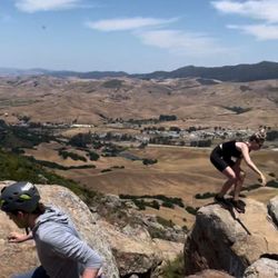
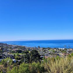
Islay Hill is a perfect hill for regular workouts. My bro lives in the neighborhood below the little mound and when visiting, I regularly do a quick hikes up/down. It takes around and hour to do a 3 mile circuit with about 550 ft. of elevation gain. The views from the top are excellent - 360* sweeping views of the area. Yes, some say Islay isn't as big, hikes as long or views as spectacular as other hills/hikes, but I think it's pretty cool for a neighborhood hill. 5 stars

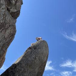
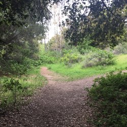
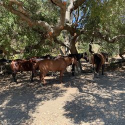
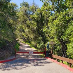
Hiking eval.: "Making a Mountain Out of a Molehill" I am not sure what some people are smoking, but for those who are not in great shape, if you do happen to take the path to the very top, it can be quite challenging. It can also be rather hazardous, since the trail is very narrow, and is composed of a lot of loose dirt. Higher up, there are wooden cross pieces that hold the dirt in place, but some are damaged, broken, or missing. If you are afraid of heights this is not a place to go. The cow with the binoculars on top of the hill is kind of cheesy, but it is a good illustration of the nice views both on the trails, and on top. Of course, since there are three different entrances, you can make the hike easier by just going part way up and then toward a far entrance. You can even return to your point of origin by either walking inside of Islay Park or in the residential areas. The hiking trail entrances, trails, & they way up the hill are maintained a bit. As for me, I made good use of hiking poles, especially on the way down. If you are as slow as I am, then you periodically need to make way for those who go faster [and in my case, that is everyone]. If you do not want to be bothered with too many other fast hikers, then going on a weekday before rush hour is a good bet. On the part of the trail that goes down to the Orcutt Road side, there can be quite a few cows in the afternoon and thus there is Cow Manure to avoid. Of course, rating the difficulty of any given trail depends upon a whole host of factors. I think Alltrails, which I do use with a grain of salt, rates this one as easy to moderate. As for me, I rate it difficult to get to the top & down. Including walking in Islay Park & the residential area, we did close to 6 miles of either walking or hiking. I already broke my back & knee from various falls in the past, so I am especially cautious. One definitely needs to have either trail sneakers or hiking shoes in view of the dirt and the real possibility of slipping. Not that anyone plans to get injured, but this trail is so narrow toward the top and the slope is so steep, I do not see how a rescue can easily happen on the way up. While I hear that this is "easier" than going up Bishop Peak, I imagine it is all relative. I think even though this is called a hill, once you manage to get up on top, it sure seems more like a "mountain", but I grew up in the Flatlands area of Brooklyn....which was...quite Flat! read more


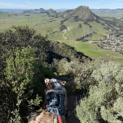
One of the easier hikes out of the "Nine Sisters". It's definitely moderate and gets a little harder towards the top. You'll be rewarding with a great, 360 view of San Luis Obispo. Wear some sunscreen and a hat as there's no cover here to protect you from the sun. I started from the trail entrance near the Islay Hill Park (where I also parked my car). There's a cow statue at the top which I found hilarious. Wasn't expecting that but there are cows and farms in the area so it makes sense. It's also neat that they had dog leashes for free at one of the trail entrances since dogs are allowed on leash here. read more


5 years ago
Quick hike - only takes around 30 minutes to get up! Recently moved to the neighborhood, so I'm excited to incorporate this into my regular workouts. Offers sweeping views of SLO that differ from your typical Bishop, Madonna, etc. views. read more


10 years ago
Islay Hill is a perfect hill for regular workouts. My bro lives in the neighborhood below the little mound and when visiting, I regularly do a quick hikes up/down. It takes around and hour to do a 3 mile circuit with about 550 ft. of elevation gain. The views from the top are excellent - 360* sweeping views of the area. Yes, some say Islay isn't as big, hikes as long or views as spectacular as other hills/hikes, but I think it's pretty cool for a neighborhood hill. 5 stars read more


7 years ago
Easy quick hike with a great view. No uneasy slopes and is shorter than most trails in slo so it's great for beginners. A special random surprise at the top definitely worth the Tiny adventure read more


7 years ago
11 years ago
9 years ago
8 years ago
More info about Islay Hill
1398 Sweet Bay Ln
San Luis Obispo, CA 93401
Directions
Hours
Indoor Amenities
Outdoor Amenities
Ask the Community - Islay Hill
Review Highlights - Islay Hill
You might also consider


Islay Hill - hiking - Updated May 2026
Best of San Luis Obispo
People found Islay Hill by searching for…
Hiking Trails in San Luis Obispo, California
Things to Do With Kids in San Luis Obispo, California
Parks in San Luis Obispo, California
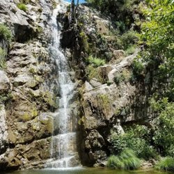
Waterfall Hike in San Luis Obispo, California
Walking Trails in San Luis Obispo, California
Dog Friendly Hiking Trails in San Luis Obispo, California
Scenic View in San Luis Obispo, California
Dog Friendly Things to Do in San Luis Obispo, California
Easy Hikes in San Luis Obispo, California
Off Road Trails in San Luis Obispo, California
View Points in San Luis Obispo, California
Parks for Kids in San Luis Obispo, California
Hiking With Kids in San Luis Obispo, California
Night View in San Luis Obispo, California
Night Hike in San Luis Obispo, California
Trail in San Luis Obispo, California
Shaded Hike in San Luis Obispo, California
Dog Friendly Parks in San Luis Obispo, California
Running Trails in San Luis Obispo, California
Stroller Friendly Hikes in San Luis Obispo, California
Playground in San Luis Obispo, California
Hikes With Dogs in San Luis Obispo, California
Trending Searches in San Luis Obispo, CA
Botanical Gardens near Islay Hill
Bounce House Rentals near Islay Hill
Cherry Picking near Islay Hill
Dog Friendly Things To Do near Islay Hill
Nurseries & Gardening near Islay Hill
Outdoor Activities near Islay Hill
Outdoor Furniture Stores near Islay Hill
Party Equipment Rentals near Islay Hill
Pick Your Own Farms near Islay Hill
Places To Take Pictures near Islay Hill
Running Trails near Islay Hill
Strawberry Picking near Islay Hill
Swimming Holes near Islay Hill
Browse Articles
Browse Nearby
BEST of San Luis Obispo, California Things to Do near Islay Hill
BEST of San Luis Obispo, California Restaurants near Islay Hill
BEST of San Luis Obispo, California Coffee near Islay Hill
BEST of San Luis Obispo, California Walking Trails near Islay Hill
BEST of San Luis Obispo, California Parks near Islay Hill
BEST of San Luis Obispo, California Campgrounds near Islay Hill
BEST of San Luis Obispo, California Breakfast near Islay Hill
Browse Brands
Related Searches in San Luis Obispo, CA
Affordable Kayak Rental Services in San Luis Obispo, California
Best Fishing Locations and Guides in San Luis Obispo, California
Best Places for Horseback Riding in San Luis Obispo, California
Best Places for Stunning Views in San Luis Obispo, California
Check Out Off Road Trails in San Luis Obispo, California
Discover Dog Friendly Trails to Explore in San Luis Obispo, California
Discover Scenic Mountain Bike Trails Near San Luis Obispo, California
Discover Scenic Waterfall Spots in San Luis Obispo, California
Discover Top State Parks to Visit in San Luis Obispo, California
Discover a Hiking Trail in San Luis Obispo, California
Discover the Best Night Hike Trails in San Luis Obispo, California
Dog-Friendly Hikes With Dogs in San Luis Obispo, California
Enjoy Camping Adventures Around San Luis Obispo, California
Enjoy Exciting Mountain Biking Adventures in San Luis Obispo, California
Enjoy Kayaking Adventures in San Luis Obispo, California
Enjoy Tent Camping Spots Around San Luis Obispo, California
Enjoy a Beautiful Waterfall Hike in San Luis Obispo, California
Enjoy the Best Picnic Spots and Ideas in San Luis Obispo, California
Enjoy the Best Walking Trails in San Luis Obispo, California
Experience Thrilling White Water Rafting in San Luis Obispo, California
Explore Beautiful Parks and Green Spaces in San Luis Obispo, California
Explore Easy Hikes Perfect for All in San Luis Obispo, California
Explore Fun Activities to Do in San Luis Obispo, California
Explore Popular Campgrounds Near San Luis Obispo, California
Explore Top Dog Parks in San Luis Obispo, California Near You
Explore the Best Beach Spots in San Luis Obispo, California
Explore the Best Boating Spots in San Luis Obispo, California
Explore the Best Trail Options in San Luis Obispo, California
Family Friendly Hiking With Kids in San Luis Obispo, California
Find Beautiful Views in San Luis Obispo, California
Find Popular Ziplining Spots Around San Luis Obispo, California
Find the Best Playgrounds to Visit in San Luis Obispo, California
Find the Best Scenic View Locations in San Luis Obispo, California
Great Places to Walk in San Luis Obispo, California
Hiking Trails With Waterfalls in San Luis Obispo, California
Off Leash Dog Hiking Trails in San Luis Obispo, California
Plan a Scenic Drive Route Near San Luis Obispo, California
Popular Outdoor Activities to Try in San Luis Obispo, California
Popular Picnic Spots to Visit in San Luis Obispo, California
Popular Things to Do in San Luis Obispo, California
Safe River Swimming Areas in San Luis Obispo, California
Safe and Fun Parks for Kids in San Luis Obispo, California
Top Paddleboarding Activities in San Luis Obispo, California
Top Places for Snorkeling in San Luis Obispo, California
Top Playgrounds for Kids to Enjoy in San Luis Obispo, California
Top Running Trails to Explore in San Luis Obispo, California
Top Swimming Lakes to Enjoy in San Luis Obispo, California
Top Swimming Spots and Pools in San Luis Obispo, California
Top Things to Do With Kids in San Luis Obispo, California
Walk Dog Friendly Hiking Trails in San Luis Obispo, California
People who viewed Islay Hill also viewed
Bishop Peak
173 reviews
Sycamore Crest Trail
16 reviews
Pismo Preserve
56 reviews
Bob Jones Trail
131 reviews
Los Osos Elfin Forest
72 reviews
James Way Oak habitat And Wildlife Preserve
3 reviews
Irish Hills trails
2 reviews
Ontario Ridge Trail Head at Shell Beach
6 reviews
Jim Green Trail
4 reviews
Oso Flaco Lake and Dunes
56 reviews