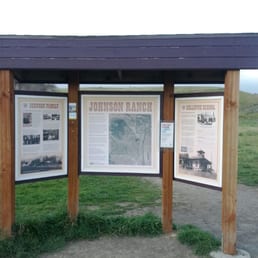
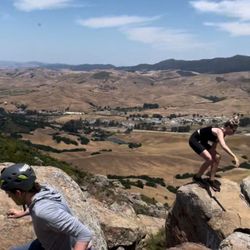
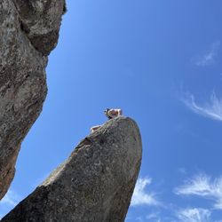
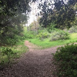
Johnson Ranch Trail Photos


You might also consider
More like Johnson Ranch Trail
Recommended Reviews - Johnson Ranch Trail
Start your review...

Reviews With Photos

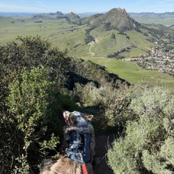
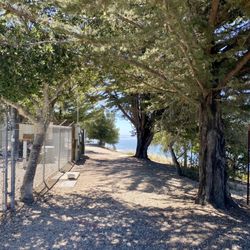
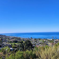
This is a real hidden gem of a trail run! Located off the far end of Higuera street, this large open space will have your thinking that you are far off in the country, not just a mile south of San Luis Obispo. The views are absolutely stunning with rolling hills and oak trees in every direction. I often find myself stopping mid-run to snap a pic of the unbelievable scenery. If you decide to do the entire loop of the Johnson Ranch Trail, it is just under 4 miles with only a few mild inclines. I find it to be a perfect mix of slight uphill and flat land. It is a great challenge if you are like me and get bored running on flat land all the time. However, due to the lack of major uphills, this trail is popular with mountain bikers, especially on the weekends. Make sure to turn down your music if you are running so you can hear them coming and move out of the way. The best time to visit this trail is a day after it rains, when the mud is dried back to dirt and the hills turn into a stunning green. I would also aim to visit on cold or foggy SLO day because there is practically no shade. This trail is one of my all time favorite trail runs. I highly recommend it!


This is a really beautiful trail you can complete in about 1 1/2 to 2 hours depending on how much you stop for photos or to rest etc. the views are really spectacular and so are the photo opportunities. The trail is up and down and you should have some decent comfy and decent hiking boots/shoes. Given the recent rain, the hike is very green with lots of wild flowers along the way. A suitable trail for kids 10 years+ old but a bit on the long side for there attention span (according to my daughter!). There were some mountain bikers using the trails as well. Overall a very positive experience and worth taking if you love the outdoors and hiking trails!

I LOVE open space preserves and Johnson Ranch is no exception. I like getting my fitness on with like-minded folks who are out enjoying nature...and sweating! Nothing better than the coastal hills of California - so beautiful! Pick your activity: Hiking Mountain biking Running Dog walking (on leash) JRT is great for all - and it's close to town. 5 stars.

OMG why did I wait so long to come here? It's so wonderful. I did the longer trail and got 3.36 miles on the gps. If you come to any forks, stay to the right for the longer trail. It's about 1 mile less for the shorted trail. I saw many bikers too but make sure you have a mountain bike, helmet and some experience - it's pretty rocky and narrow at many points! Great for trail running...it's hilly but no HUGE hills to climb. This place gets busy on the weekends. Most of the trail is exposed to the sun too so keep that in mind when dressing.

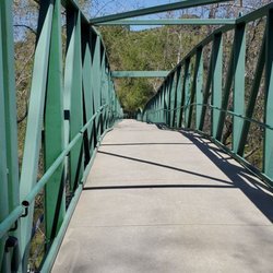
Excellent running trail! The long trail is only about 3.3 miles or so, but the hills make it a bit more of a challenge. The trail is well maintained (with a number of bridges for creek-crossings and well-trimmed trees creating a sort of natural looking alcove in the shady sections), and provides some beautiful views of SLO's rolling landscapes.

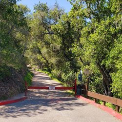
Great trail, you are going around some mountains so there are some slight hills to go up. Overall not too difficult but I would definitely bring some water because it can get hot up on the hills. This trail can be extended or shortened depending on the path that you choose on a few of the forks you come across on the trails. This trail also allows dogs but they must be kept on a leash.

1 year ago


2 years ago
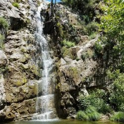
Absolutely Amazing!! The greenery after the rain makes this trail a must see. The pond is flowing with rain water, the ducks and quail are delighted with nature's natural pleasures. So quiet I could hear birds chirping in the near distance. Wild flowers are blooming spurraickily all over. It was a definite pleasure to take a long overdue walk in nature. So beautiful!!! read more


2 years ago
3.5 miles the way I go.. hour and 10 or 20 minutes w/dog ... you get elevation and a great view read more

This is a real hidden gem of a trail run! Located off the far end of Higuera street, this large open space will have your thinking that you are far off in the country, not just a mile south of San Luis Obispo. The views are absolutely stunning with rolling hills and oak trees in every direction. I often find myself stopping mid-run to snap a pic of the unbelievable scenery. If you decide to do the entire loop of the Johnson Ranch Trail, it is just under 4 miles with only a few mild inclines. I find it to be a perfect mix of slight uphill and flat land. It is a great challenge if you are like me and get bored running on flat land all the time. However, due to the lack of major uphills, this trail is popular with mountain bikers, especially on the weekends. Make sure to turn down your music if you are running so you can hear them coming and move out of the way. The best time to visit this trail is a day after it rains, when the mud is dried back to dirt and the hills turn into a stunning green. I would also aim to visit on cold or foggy SLO day because there is practically no shade. This trail is one of my all time favorite trail runs. I highly recommend it! read more


3 years ago
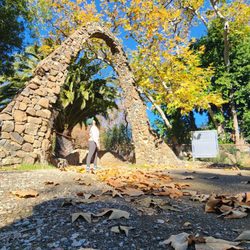
Fun spot. Went with a 1yo in a Bob stroller and was doable. Bit tricky over the rocks in some spots but not bad. read more
7 years ago
This is a really beautiful trail you can complete in about 1 1/2 to 2 hours depending on how much you stop for photos or to rest etc. the views are really spectacular and so are the photo opportunities. The trail is up and down and you should have some decent comfy and decent hiking boots/shoes. Given the recent rain, the hike is very green with lots of wild flowers along the way. A suitable trail for kids 10 years+ old but a bit on the long side for there attention span (according to my daughter!). There were some mountain bikers using the trails as well. Overall a very positive experience and worth taking if you love the outdoors and hiking trails! read more


12 years ago
I LOVE open space preserves and Johnson Ranch is no exception. I like getting my fitness on with like-minded folks who are out enjoying nature...and sweating! Nothing better than the coastal hills of California - so beautiful! Pick your activity: Hiking Mountain biking Running Dog walking (on leash) JRT is great for all - and it's close to town. 5 stars. read more


OMG why did I wait so long to come here? It's so wonderful. I did the longer trail and got 3.36 miles on the gps. If you come to any forks, stay to the right for the longer trail. It's about 1 mile less for the shorted trail. I saw many bikers too but make sure you have a mountain bike, helmet and some experience - it's pretty rocky and narrow at many points! Great for trail running...it's hilly but no HUGE hills to climb. This place gets busy on the weekends. Most of the trail is exposed to the sun too so keep that in mind when dressing. read more


7 years ago
Great family hike! I especially liked the flexibility of distance between 2.3 and 4.6 miles (you can take the yellow or orange path or do both). The green rolling hills were breathtaking! read more


7 years ago
14 years ago
Excellent running trail! The long trail is only about 3.3 miles or so, but the hills make it a bit more of a challenge. The trail is well maintained (with a number of bridges for creek-crossings and well-trimmed trees creating a sort of natural looking alcove in the shady sections), and provides some beautiful views of SLO's rolling landscapes. read more


13 years ago
Great trail, you are going around some mountains so there are some slight hills to go up. Overall not too difficult but I would definitely bring some water because it can get hot up on the hills. This trail can be extended or shortened depending on the path that you choose on a few of the forks you come across on the trails. This trail also allows dogs but they must be kept on a leash. read more


8 years ago
9 years ago
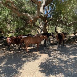
Challenging trail run / relatively flat, easy hike through beautiful terrain. If you're running, keep an eye on the uneven trail so you don't wreck an ankle. Surprisingly well-populated--even at 7:30am on a random weekday. Map directions to get here weren't right. The exit from the 101 S is Higuera, and then right after you exit you'll see a little gravel parking lot. If you're coming from the South, I think you'll have to go to Las Osas, turn around and get back on the 101 S, and then get off at Higuera. I went two days in a row because I loved it so much. Bring your pup, but per the sign at the entrance, watch out for mountain lions.... read more


10 years ago
13 years ago
7 years ago
10 years ago
11 years ago
10 years ago
11 years ago
More info about Johnson Ranch Trail
5190 Ontario Rd
San Luis Obispo, CA 93405
Directions
Hours
Outdoor Amenities
Ask the Community - Johnson Ranch Trail
Review Highlights - Johnson Ranch Trail
You might also consider


Why does Yelp recommend reviews?
Johnson Ranch Trail - hiking - Updated May 2026
Best of San Luis Obispo
People found Johnson Ranch Trail by searching for…
Hiking Trails in San Luis Obispo, CA
Flower Fields in San Luis Obispo, CA
Walking Trails in San Luis Obispo, CA
Dog Friendly Hiking Trails in San Luis Obispo, CA
Running Trails in San Luis Obispo, CA
Easy Hikes in San Luis Obispo, CA
Scenic View in San Luis Obispo, CA
Off Road Trails in San Luis Obispo, CA
Rock Quarry in San Luis Obispo, CA
Hiking With Kids in San Luis Obispo, CA
Stroller Friendly Hikes in San Luis Obispo, CA
Secret Spots in San Luis Obispo, CA
View Points in San Luis Obispo, CA
Photo Spots in San Luis Obispo, CA
Shaded Hike in San Luis Obispo, CA
Off Leash Dog Hiking Trails in San Luis Obispo, CA
Lakes & Ponds in San Luis Obispo, CA
Night Hike in San Luis Obispo, CA
Hikes With Dogs in San Luis Obispo, CA
Secluded Spots in San Luis Obispo, CA
Trending Searches in San Luis Obispo, CA
Botanical Gardens near Johnson Ranch Trail
Bounce House Rentals near Johnson Ranch Trail
Campgrounds near Johnson Ranch Trail
Cherry Picking near Johnson Ranch Trail
Cliff Jumping near Johnson Ranch Trail
Dog Friendly Things To Do near Johnson Ranch Trail
Flower Fields near Johnson Ranch Trail
Flower Shop near Johnson Ranch Trail
Garage Sales near Johnson Ranch Trail
Garden Center near Johnson Ranch Trail
Hiking near Johnson Ranch Trail
Lakes & Ponds near Johnson Ranch Trail
Nurseries & Gardening near Johnson Ranch Trail
Outdoor Activities near Johnson Ranch Trail
Outdoor Furniture Stores near Johnson Ranch Trail
Parks near Johnson Ranch Trail
Party Equipment Rentals near Johnson Ranch Trail
Pedicure near Johnson Ranch Trail
Photo Spots near Johnson Ranch Trail
Pick Your Own Farms near Johnson Ranch Trail
Picnic Areas near Johnson Ranch Trail
Places To Take Pictures near Johnson Ranch Trail
Rock Quarry near Johnson Ranch Trail
Running Trails near Johnson Ranch Trail
Scenic Night View near Johnson Ranch Trail
Secluded Spots near Johnson Ranch Trail
Star Gazing near Johnson Ranch Trail
Strawberry Picking near Johnson Ranch Trail
Sunrise View near Johnson Ranch Trail
Swimming Holes near Johnson Ranch Trail
Table And Chair Rentals near Johnson Ranch Trail
Walking Trails near Johnson Ranch Trail
Browse Nearby
BEST of San Luis Obispo, California Restaurants near Johnson Ranch Trail
BEST of San Luis Obispo, California Coffee near Johnson Ranch Trail
BEST of San Luis Obispo, California Things to Do near Johnson Ranch Trail
BEST of San Luis Obispo, California Parks near Johnson Ranch Trail
BEST of San Luis Obispo, California Breakfast near Johnson Ranch Trail
BEST of San Luis Obispo, California Beaches near Johnson Ranch Trail
BEST of San Luis Obispo, California Campgrounds near Johnson Ranch Trail
BEST of San Luis Obispo, California Hotels near Johnson Ranch Trail
Browse Brands
Related Searches in San Luis Obispo, CA
Affordable Bike Repair Services in San Luis Obispo, California
Affordable Bike Tune Up Services in San Luis Obispo, California
Affordable Kayak Rental Services in San Luis Obispo, California
Affordable Tandem Bike Rental in San Luis Obispo, California
Best Dirt Bike Riding Spots in San Luis Obispo, California
Best Electric Bike Rental Services in San Luis Obispo, California
Best Fishing Locations and Guides in San Luis Obispo, California
Best Nature Trails for Hiking in San Luis Obispo, California
Best Places for Horseback Riding in San Luis Obispo, California
Best Places for Stunning Views in San Luis Obispo, California
Best Used Bikes for Sale Near San Luis Obispo, California
Check Out Off Road Trails in San Luis Obispo, California
Discover Dog Friendly Trails to Explore in San Luis Obispo, California
Discover Popular Bike Tours in San Luis Obispo, California
Discover Popular Bike Trails in San Luis Obispo, California
Discover Scenic Bike Paths in San Luis Obispo, California
Discover Scenic Mountain Bike Trails Near San Luis Obispo, California
Discover Scenic Waterfall Spots in San Luis Obispo, California
Discover Top State Parks to Visit in San Luis Obispo, California
Discover a Hiking Trail in San Luis Obispo, California
Discover the Best Night Hike Trails in San Luis Obispo, California
Dog-Friendly Hikes With Dogs in San Luis Obispo, California
Enjoy Biking Adventures Around San Luis Obispo, California
Enjoy Camping Adventures Around San Luis Obispo, California
Enjoy Exciting Mountain Biking Adventures in San Luis Obispo, California
Enjoy Hiking Adventures in San Luis Obispo, California
Enjoy Kayaking Adventures in San Luis Obispo, California
Enjoy Tent Camping Spots Around San Luis Obispo, California
Enjoy a Beautiful Waterfall Hike in San Luis Obispo, California
Enjoy the Best Picnic Spots and Ideas in San Luis Obispo, California
Enjoy the Best Tubing Experiences in San Luis Obispo, California
Enjoy the Best Walking Trails in San Luis Obispo, California
Experience Thrilling White Water Rafting in San Luis Obispo, California
Explore BMX Bike Shops Near San Luis Obispo, California
Explore Beautiful Parks and Green Spaces in San Luis Obispo, California
Explore Bike Rentals Throughout San Luis Obispo, California
Explore Easy Hikes Perfect for All in San Luis Obispo, California
Explore Electric Bikes Available in San Luis Obispo, California
Explore Fun Activities to Do in San Luis Obispo, California
Explore Nature Spots Around San Luis Obispo, California
Explore Popular Campgrounds Near San Luis Obispo, California
Explore Popular Scenic Overlook Points in San Luis Obispo, California
Explore Popular View Points Around San Luis Obispo, California
Explore Scenic Lakes to Visit in San Luis Obispo, California
Explore Secret Spots Worth Visiting in San Luis Obispo, California
Explore Top Dog Parks in San Luis Obispo, California Near You
Explore the Best Beach Spots in San Luis Obispo, California
Explore the Best Boating Spots in San Luis Obispo, California
Explore the Best Trail Options in San Luis Obispo, California
Family Friendly Hiking With Kids in San Luis Obispo, California
Browse Articles
People who viewed Johnson Ranch Trail also viewed
Bishop Peak
173 reviews
Sycamore Crest Trail
16 reviews
Pismo Preserve
56 reviews
Bob Jones Trail
131 reviews
James Way Oak habitat And Wildlife Preserve
3 reviews
Ontario Ridge Trail Head at Shell Beach
6 reviews
Jim Green Trail
4 reviews
Hazard Peak Trail
3 reviews
Irish Hills trails
2 reviews
Oso Flaco Lake and Dunes
56 reviews