Furman Square Photos


More like Furman Square
Recommended Reviews - Furman Square
Start your review...

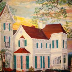
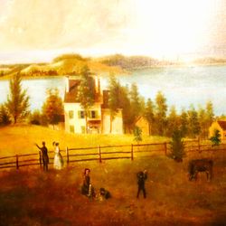
Furman Square has been here forever, but was officially named and dedicated in 1993. It lies on the West side of South Ocean Avenue, just below Main Street (between Dragon and Phoenix Resturant (http://www.yelp.com/biz/dragon-and-phoenix-restaurant-patchogue#hrid:IVd-2YqxaIkZsNTd40EU6Q?fsid=9OcBmmLwE7sEZyvxsCEX-A) and Jimmy's Quality Shoe Repairing). The Square has a bench, a tree, some kind of Village Marker, and a one-way traffic inlet into the Church Street Municipal Parking Field. There is an unremarkable mural on the wall to the North, but the true attraction here is the Hans Gabali painting on the Southern wall. It features old-timey sights of South Ocean Avenue (see pics): 1. A dedication for the Incorporated Village Centennial. 2. Imagery of the (now bygone) Suffolk Traction Company. 3. The old Academy Street School (which is also gone). 4. An early Twentieth Century depiction of the Southeast buildings of the Four Corners. 5. The (still-there) Methodist Church (http://www.yelp.com/biz_photos/U1-bhlcgRzGn7vQQzDBlPw?select=Ju0C1UqSeC40VwyY_JSvRw). 6. Colby's Ice Cream Parlor (formerly on the corner of South Ocean and Smith St., now relocated) 7. (What I assume is) The old Mascot Dock and Public Bathing Beach. It's a great mural and Patchogue is lucky to have a Gabali piece of such a historic and personal nature. read more


More info about Furman Square


Furman Square - landmarks - Updated July 2026
Best of Patchogue
People found Furman Square by searching for…
Parking in Patchogue, New York
Churches in Patchogue, New York
Things to Do in Patchogue, New York
Attractions in Patchogue, New York
Scenic View in Patchogue, New York
Places to Take Pictures in Patchogue, New York
Public Services & Government in Patchogue, New York
Fun Things to Do at Night in Patchogue, New York
Photo Spots in Patchogue, New York
Tourist Attractions in Patchogue, New York
Date Ideas in Patchogue, New York
Public Art in Patchogue, New York
Scenic Overlook in Patchogue, New York
Historic Restaurants in Patchogue, New York
Fun Places to Go in Patchogue, New York
Night View in Patchogue, New York
Religious Organizations in Patchogue, New York
Sunday Night in Patchogue, New York
Beautiful Views in Patchogue, New York
Boardwalk in Patchogue, New York
Public Library in Patchogue, New York
Browse Articles
Browse Nearby
BEST of Patchogue, New York Restaurants near Furman Square
BEST of Patchogue, New York Things to Do near Furman Square
BEST of Patchogue, New York Coffee near Furman Square
BEST of Patchogue, New York Museums near Furman Square
BEST of Patchogue, New York Photo Spots near Furman Square
BEST of Patchogue, New York Hotels near Furman Square
BEST of Patchogue, New York Breakfast near Furman Square
Browse Brands
Trending Searches in Patchogue, NY
Black Owned Nail Salons near Furman Square
Boat Rental near Furman Square
Cliff Jumping near Furman Square
Fishing Spots near Furman Square
Flower Fields near Furman Square
Jet Ski Rental near Furman Square
Kayak Rental near Furman Square
Landmarks & Historical Buildings near Furman Square
Lighthouses near Furman Square
Picnic Areas near Furman Square
Places To Visit near Furman Square
Pool Day Pass near Furman Square
Public Pools near Furman Square
River Swimming near Furman Square
Scenic Restaurants near Furman Square
Secluded Spots near Furman Square
Sightseeing near Furman Square
Soccer Store near Furman Square
Strawberry Picking near Furman Square
Sunrise View near Furman Square
Swimming Holes near Furman Square
Swimming Lakes near Furman Square
Things To Do This Weekend near Furman Square
People who viewed Furman Square also viewed
Lake Ronkonkoma Roadside Memorial
2 reviews
TWA Flight 800 Memorial
10 reviews
Mastics-Moriches-Shirley Community Library
11 reviews
Brentwood Public Library
5 reviews
Center Moriches Free Public Library
6 reviews
Eaton's Neck Lighthouse
1 review
Patchogue-Medford Library
11 reviews
Harborfields Public Library
6 reviews
Sayville Chamber of Commerce
2 reviews
Port Jefferson 9/11 Memorial
1 review