Cancel

    Open app

    Search

    Franconia Falls

    5.0 (2 reviews)

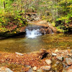
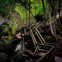
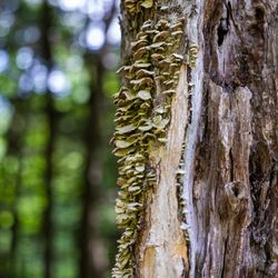
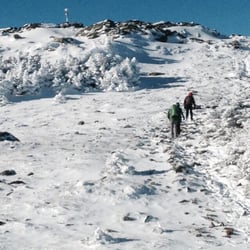
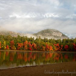
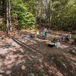
    Franconia Falls Photos

    You might also consider

    Recommended Reviews - Franconia Falls

    Your trust is our priority, so businesses can't pay to alter or remove their reviews. Learn more about reviews.
    Yelp app icon
    Browse more easily on the app
    Review Feed Illustration

    18 years ago

    Helpful 5
    Thanks 0
    Love this 2
    Oh no 0

    10 years ago

    Helpful 0
    Thanks 0
    Love this 0
    Oh no 0

    Verify this business for free

    People searched for Hiking 178 times last month within 15 miles of this business.

    Verify this business

    Lost River Gorge

    Lost River Gorge

    (91 reviews)

    Stumbled across Lost River when planning a trip to NH to see the fall foliage. I absolutely love…read morethe Flume Gorge trail & this one wasnt too far away. I had heard there were gorges & caves to explore different from other trails nearby along with beautiful pines and waterfalls. It exceeded all my expectations! It says this is a 1 mile loop hike but be prepared- I walk a 5k daily & this trail kicked my butt in a good way. It was moderately challenging- I went in the rain so it was a bit cooler too. The best advice I could offer is to take a backpack with snacks, another jacket just in case (although i layered up), pack rain pants to help keep me warm in the rain, and shoes with good traction. And plenty of water. Beanies may also be a good option to keep your head warm from the cold. And a portable battery. Also, if you haven't traveled with a car like me..then the Shuttle Connection is a life saver to travel in town. Way cheaper than Uber and fairly quick to transport you wherever you want to go. Also for travelers go back and forth to other states travel by bus is the perfect and most affordable way to travel. This trail offered amazing views, great photo ops, and plenty of additional trails to explore. They also make sure to keep everything maintained and safe for hikers exploring. Everything is well labeled and easy to follow. They do say and I can attest- travelers who have difficulty walking or have walkers etc..this may not be an ideal trail. Also, for younger children this may not be an kdela hike because of how extensive the elevation is. You are climbing a mountain and waterfall elevation. Make sure to look up details on their trail before you plan a trip. But well worth the hike :)

    Our family loved the gorge and caves. We've been to NH a few times, but our kids are on the younger…read moreside so this was a first for us. The boardwalk is not only a great help to get through the gorge, its craftsmanship is amazing. The hand railings are rounded and smooth, and we were even able to chat with one of the carpenters on our visit as he installed a new section of boardwalk. The caves themselves are not really caves in the traditional sense, rather the negative space between boulders and the earth & other boulders. That didn't detract from their awesomeness as it's amazing to think that these giant boulders were moved by ice. We spent about 2 hours going through the caves and doing the extra loop through the suspension bridge. My boys tried a few caves more than once and even made it through the Lemon Squeeze! The main building looks newer, is very clean and comfortable. There isn't somewhere to sit in the shade, but we weren't there long enough to really miss that's however, if you brought a lunch or had someone in your party who needed to wait this one out, there are some picnic tables surrounding the main building.

    Lincoln Woods Trail - Connecting paths

    Lincoln Woods Trail

    (3 reviews)

    Stunning entry point to the Pemigewasset Wilderness!…read more I was looking for a short hike to salvage the great weather we had at the end of a rainy weekend and this one came across my facebook feed of all places. I was amped though because I was hoping for 3 things this trip to NH: viewpoints, water, and bridges. This had 2/3 and The Flume had given me the last piece the day prior. I got there around 11 which seemed to be pretty early as the trail was empty. So empty I second guessed myself as there were bear warning signs and no cell reception. After a brief pep talk I continued on my way. So glad I did because eventually other day and thru hikers joined the path. This trail goes for a little over 3 miles and ends at a waterfall and connects to other trails and mountains in the Whites. Much of it is abandoned railway and the old planks are still partially exposed along the path. The view downriver is breathtaking. I must have stood on the suspension bridge for 20 minutes taking it all in. Were it a bit warmer I would have joined some of the other brave souls and dipped my feet in! Things to know: -paid parking for a nominal fee. They have machines and the trust system. -tons of parking spaces -restrooms though I can't say if they're flush or not -right off the Kanc and close to Loon Mountain I can show you better than I can tell you - enjoy my pics!

    We came during foliage season and it was one of the best spots to see foliage. We parked at the…read moremain parking lot right off the Kancamagus Highway and we only walked for about 5 minutes to get into water. We did not finish the 3+ mile trail, we came back to the parking lot after a short walk. This parking lot could get very busy during Fall, so I suggested either go early or go late during foliage season.

    The Flume Gorge

    The Flume Gorge

    (193 reviews)

    I only visit New Hampshire once a year and I always like to take the hike through the Flume!…read moreWhat's nice is that even if it's a hot sunny summer day that inside the flume you're shaded from the sun by the trees and the formations so it makes for a nice little hike! The one time I did go in cooler weather was early October and that time there was the abundance of leave changing colors to be seen so that also another good time to visit.

    While we were traveling through this part of NH, my husband and I knew we wanted to do outdoorsy…read morethings while also knowing our aging joints and city DNA might not allow for hardcore outdoorsy things. Enter the Flume Gorge. The whole trail is well-marked and was roughly two miles of walking for us, with some occasional hills and terrain. All along the way, there was plenty of nature to appreciate, with the waterfalls being the clear highlight of the show. My inner nerd loved the various signs and placards throughout the course that either gave travelers information about the flora, fauna, or geological history of different spots. I especially appreciate that there are limited numbers of tickets that are sold within time slots. I presume that's to keep the trail from getting too loud or crowded. My husband and I caved into the strong recommendations to purchase tickets online (the prevailing reason seems to be avoiding the peril of 'sold out tickets', but when we bought ours the night before our visit, there were still more than enough spots available). There are bathrooms available at the start of the hike (and technically also at the end, since the trail is circular). The visitor center/store is connected to the restrooms, though it's implicitly recommended to enter at the end of your hike since there's no reentering the trail once you come into the store. For those famished at the end of their visit, there's also a small food court selling fast food items and a modestly sized seating area. We paid $37 for two advance tickets (which includes a dollar 'print at home' surcharge, even if there's a scannable barcode included in the confirmation email that prevents needing to print anything). Parking was fine in the private lot and plentiful, especially during the early morning slot we took. Overall, this is a nice and easy hike for those who want to connect with nature on a non-intense hike.

    Mount Osceola - View from the summit!

    Mount Osceola

    (3 reviews)

    Great view. Trailhead on Tripoli Road. Parking lot fee it…read more$5. You can go to both Mount Osceola and East Osceola. Total 8.2 miles, 2871 feet elevation gain. View is great from MOunt Osceola. This mountain valley is a place of clouds hanging, so the view is kind of dramatic. East peak was in the clouds and I couldn't see the view, but when I was there in winter there was a view (East peak itself doesn't have a view but there is a view point a bit beyond the summit).

    Heave, ho and hoist! What a climb! Ascending Osceola (and East Osceola) via the Osceola Trail was…read morea moderate climb. Most peak-baggers choose to snatch up both Osceola's main peak (4,315 feet) as well as nearby East Osceola (4,156 feet); though you can approach from either the South or the East, I would recommend the Southern trail head off of Tripoli Rd as your base (roundtrip distance: 7.4 miles); 3$ to park at the base. The lower half of the trail was rocky (though I found this quaint on my way up, loose footing on the descent was rather frustrating) and several spots where the trail runs over large slabs of diagonal stone. About 3/4 of the way up to peak 1 there are fantastic views of Mt Tecumseh to the South (a serious temptation and a fabulous motivator to continue on up up UP!). The view from the top is phenomenal; the slab spreads out and reveals the valley far below - the morning of my hike the clouds played kaleidoscope with the sun, skittering shadows on the Earthen treescape *and I'm in love with hiking all over again* Traveling on to the East peak seemed like a cinch, only one mile away over rocky trodden trail. There is a very difficult craig called "the Chimney" as you descent to the col; about fifty-feet of tricky rocky tetris hard-footing. There IS a round-about/"cheaters" route which is considerably less difficult which I would recommend for descent, but I challenged myself on the return (I was VERY thankful to be in a caravan at that point!). East peak is a bit of a let down after the grande sweeping views of the previous summit (just a pile of rocks really, I walked past this "marker" before I had even realized what it identified). There are a couple of peekaboo viewpoints Northeast along this short trail which are quite nice, and made returning to the peak all that more enjoyable. It is easy to understand why this is one of the most popular hikes in the Whites. I passed all typed on my trek: singles, couples, friends, and families - it is a moderate hike with fantastic visual rewards!

    Outdoor Escapes New Hampshire - Autumn colors in NH on a custom photo tour.

    Outdoor Escapes New Hampshire

    (3 reviews)

    I do not recommend any "Moose Tours" with Lucie. We drove 3 hours to meet her and she was an hour…read morelate to the meeting point(no cell service to contact her), completely unprepared for us as she "pulled the wrong file" "what did I tell you we were doing" We basically drove up and down route 26 for 6 hours looking for moose on the side of the highway. She stopped to asked the locals where to find moose and spoke endlessly about the types of trees in NH. No moose were spotted at all even after a desperate mosquito infested walk through the woods (yes, we had bug spray but it didn't make a difference). We were told "plan B" was to drive up and down the same highway at midnight to see if the moose were out. This was a surprise for my husbands birthday, It was a surprise for both of us! This was a complete waste of time and money.

    What a great experience we had and most of all a beautiful day with a great guide! I booked a one…read moreday trip kayaking for Lisa and I and it couldn't have went any better. Lucy met us in the morning and we went straight to the river. It was such a gorgeous and enjoyable ride and she was so pleasant and relaxed the whole way through. She gave us some simple tips on kayaking and also some nice information on some of the wildlife and history of the area. When we reached Lake Ossipee the wind was very strong which made the lake very choppy and her lead was so assuring in the challenge that lay ahead of us - she was awesome and we made it to the other side of the lake without any issues whatsoever. I would highly recommend Lucy if you want to experience a great day outdoors in the White Mountains

    Tripoli Road - Camp site

    Tripoli Road

    (11 reviews)

    Honestly if I could give this a negative 100 star review, I probably would. So where we start…read more These campsites are trash in trash out campgrounds. No one follows the rules ever. There shouldn't be broken beer bottles littered everywhere or toilet papers and wet wipes scattered in the woods. That isn't even the worse part. We come camping to disconnect from electronics in order to be one with nature. However, there are people that come with generators and karaoke machine, strobe lights to name the least. I get it. Everyone wants to have a good time. Be considerate of your neighbors. Having raves and karaoke parties until early in the morning is not fun. Especially when they have their volumes at 100. This used to be a great place to come and reconnect with your families. Not anymore.

    It's been at least 7 or 8 years since I've gone camping here annually. If you want some peace and…read morequite, this is the place to camp. No curfews, no one on top of you... just camp out and do your own thing. Such a great place, we always set up camp by the stream. There's no bathroom or wash area so this is not for the glampers! Although there's porter potties up the closer to the entrance for those who doesn't want to take a squat in the woods! Prices of car has gone up over the years but not too drastic. Prices of wood was $7/bundle when I was there. Can always drive to town to get cheaper wood...$3/bundle. When your week is done, pack up and leave. Remember to pick up after yourself! Hope people who come here wouldn't ruin this places natural beauty because I hope to come back every year!

    Franconia Falls - hiking - Updated May 2026

    Loading...
    Loading...
    Loading...