Mt. Chocorua Photos


You might also consider
More like Mt. Chocorua
Recommended Reviews - Mt. Chocorua
Start your review...

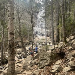
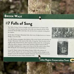
Travel 1.5 hrs Will recommend Will return I used the Brooke to liberty Trail there are some very steep slab parts of the trail about 2 miles in I am not that experienced of a hiker and it was OK for me to do. I was intimidated looking at it but once I got my foot grip down, I was OK to continue. There are slippery spots due to being running water off of the mountain the views are breathtaking. The sounds of the babbling Brooks and the little waterfalls are beautiful. and just being in the woods there is just amazing. Everything is alive and I mean that by saying not lots of dead trees around I mean there is dead trees, but it's so much alive that you don't really see the dead trees. it's very dense woods. we did not take the trail that leads all the way to the top of Mount Chocorua (piper) we had a very challenging night the night before with our other tenants of the building so it was best that we had not done that without doing that we had a 7 1/2 mile hike had we included that it probably would've been a 9 mile hike. We took our time and had small 15 minute breaks and in total it took us about 6 1/2 hours, but it can definitely be done in four if you do straight hike up straight hike down. Going down liberty Trail. It was a little bit more wet and mushy because you're going down the mountain and the streams are running down mountain but I didn't care. I have hiking shoes that are intended to get wet so and you can find alternate routes through the woods if you choose to do so it still wouldn't deter me from coming back For the parking you do have to drive down what looks to be a snowmobile trail. Don't be afraid of that. Yes, there is parking enough of it directly where your GPS leads you. I hope you all enjoy your hike read more


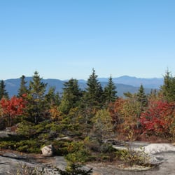
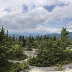
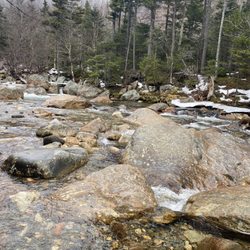
It is very nice view from the top and on the ridge. On 2018/5/6, the snow was almost all melted on the trail and easier to hike. Some sections are very rocky and hard to climb up for short person like me but doable. It is recommended doing on a sunny nice day. We started at Piper trailhead climbed up through Weetamoo trail and came down via carter ledge trail. 9 mile loop, 3000 feet elevation gain. read more


Mt. Chocorua is the highest peak I've ever conquered. A recommendation from a fellow hiker friend and it did not disappoint. CG and I were originally looking for the Piper trail but the GPS failed us and we found ourselves at the start of the Liberty trail. Off we went! It was a fly swatting, rock climbing, sweaty 3 hrs to the top for us. We both had not worked out in awhile and watched everyone and their dogs pass us. The trail could be marked a little better but we managed. The last mile or so was the most strenuous -- I was beyond exhausted when we finally reached the top but man, it was worth every ache and drop of sweat. The 360 degree views were breathtaking and the best of any hike I've done. The roundtrip took about 5.5 hours. I blame all the recent ice cream. I highly recommend this hike. As always, bring enough water and a camera to capture the amazing panoramic view! read more


So I went hiking up liberty trail and it was great! Unfortunately there were moments where my boyfriend and I stepped and our feet sunk into mud and our socks got wet, but it wasn't a deal breaker. The trail was well marked with yellow tape, also was pretty obvious because it always had a path in way to follow. When you drive to liberty trail location the road is somewhat narrow, but not hard to drive through by any means. There is an area for you to park and a sign that has the map of the trail. It says it is 3.9 miles and I would rate this trail difficult (more than moderate because of rocks,incline, and maneuvers). One downside to us going in the fall was that there was a lot of leaves on the ground at the beginning of the trail and it was a bit tough to maneuver due to there being a ton of smaller rocks hidden beneath so I sure tripped a lot! But I never fell! read more

13 years ago
17 years ago
More info about Mt. Chocorua
Chocorua, NH 03817
Directions
Hours
Outdoor Amenities
Ask the Community - Mt. Chocorua


Mt. Chocorua - hiking - Updated July 2026
Best of Chocorua
People found Mt. Chocorua by searching for…
Things to Do in Chocorua, New Hampshire
Hiking Trails With Waterfalls in Chocorua, New Hampshire
Rock Climbing in Chocorua, New Hampshire
Parks in Chocorua, New Hampshire
Waterfalls and Swimming Holes in Chocorua, New Hampshire
Places to Take Pictures in Chocorua, New Hampshire
View Points in Chocorua, New Hampshire
Running Trails in Chocorua, New Hampshire
Secret Spots in Chocorua, New Hampshire
Easy Hikes in Chocorua, New Hampshire
Lookout Points in Chocorua, New Hampshire
Beautiful Views in Chocorua, New Hampshire
Hiking With Kids in Chocorua, New Hampshire
Waterfalls in Chocorua, New Hampshire
Off Road Trails in Chocorua, New Hampshire
Scenic Views in Chocorua, New Hampshire
Walking Trails in Chocorua, New Hampshire
Dog Hiking Trails in Chocorua, New Hampshire
Lakes & Ponds in Chocorua, New Hampshire
Scenic Places in Chocorua, New Hampshire
Parks for Kids in Chocorua, New Hampshire
Dog Friendly Trails in Chocorua, New Hampshire
Browse Nearby
BEST of Chocorua, New Hampshire Restaurants near Mt. Chocorua
BEST of Chocorua, New Hampshire Coffee near Mt. Chocorua
BEST of Chocorua, New Hampshire Breakfast near Mt. Chocorua
BEST of Chocorua, New Hampshire Things to Do near Mt. Chocorua
BEST of Chocorua, New Hampshire Shopping near Mt. Chocorua
BEST of Chocorua, New Hampshire Fishing near Mt. Chocorua
BEST of Chocorua, New Hampshire Campgrounds near Mt. Chocorua
BEST of Chocorua, New Hampshire Ski Resorts near Mt. Chocorua