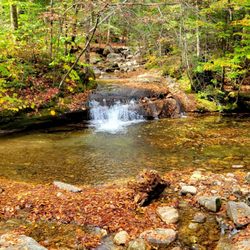
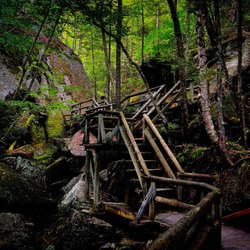
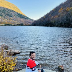
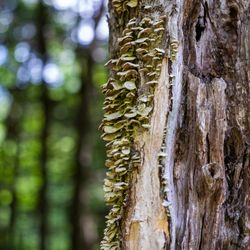
Cancel

    Open app

    Search

    Tripoli Road

    3.5 (11 reviews)

    Tripoli Road Photos

    You might also consider

    Recommended Reviews - Tripoli Road

    Your trust is our priority, so businesses can't pay to alter or remove their reviews. Learn more about reviews.
    Yelp app icon
    Browse more easily on the app
    Review Feed Illustration

    2 years ago

    Helpful 1
    Thanks 0
    Love this 0
    Oh no 1

    9 years ago

    Helpful 2
    Thanks 0
    Love this 1
    Oh no 0

    15 years ago

    Helpful 4
    Thanks 0
    Love this 4
    Oh no 0

    11 years ago

    Helpful 2
    Thanks 0
    Love this 2
    Oh no 0
    Photo of Rick G.
    6
    232
    5

    9 years ago

    Helpful 2
    Thanks 0
    Love this 2
    Oh no 0

    14 years ago

    Helpful 0
    Thanks 0
    Love this 0
    Oh no 0

    10 years ago

    Helpful 0
    Thanks 0
    Love this 0
    Oh no 0

    14 years ago

    Helpful 0
    Thanks 0
    Love this 0
    Oh no 0

    13 years ago

    Helpful 0
    Thanks 0
    Love this 0
    Oh no 0

    18 years ago

    Helpful 7
    Thanks 0
    Love this 4
    Oh no 0

    16 years ago

    Helpful 1
    Thanks 0
    Love this 1
    Oh no 0

    Ask the Community - Tripoli Road

    Do you camp right next to your vehicle? Or do you have to lug all the gear to your site?

    Minimal walking, but there are sites that require a trek if you want to be near the river.

    Don’t See Your Question? Ask Away!

    Verify this business for free

    People searched for Parks 117 times last month within 15 miles of this business.

    Verify this business

    Lost River Gorge

    Lost River Gorge

    4.6(91 reviews)
    9.6 mi

    Stumbled across Lost River when planning a trip to NH to see the fall foliage. I absolutely love…read morethe Flume Gorge trail & this one wasnt too far away. I had heard there were gorges & caves to explore different from other trails nearby along with beautiful pines and waterfalls. It exceeded all my expectations! It says this is a 1 mile loop hike but be prepared- I walk a 5k daily & this trail kicked my butt in a good way. It was moderately challenging- I went in the rain so it was a bit cooler too. The best advice I could offer is to take a backpack with snacks, another jacket just in case (although i layered up), pack rain pants to help keep me warm in the rain, and shoes with good traction. And plenty of water. Beanies may also be a good option to keep your head warm from the cold. And a portable battery. Also, if you haven't traveled with a car like me..then the Shuttle Connection is a life saver to travel in town. Way cheaper than Uber and fairly quick to transport you wherever you want to go. Also for travelers go back and forth to other states travel by bus is the perfect and most affordable way to travel. This trail offered amazing views, great photo ops, and plenty of additional trails to explore. They also make sure to keep everything maintained and safe for hikers exploring. Everything is well labeled and easy to follow. They do say and I can attest- travelers who have difficulty walking or have walkers etc..this may not be an ideal trail. Also, for younger children this may not be an kdela hike because of how extensive the elevation is. You are climbing a mountain and waterfall elevation. Make sure to look up details on their trail before you plan a trip. But well worth the hike :)

    Our family loved the gorge and caves. We've been to NH a few times, but our kids are on the younger…read moreside so this was a first for us. The boardwalk is not only a great help to get through the gorge, its craftsmanship is amazing. The hand railings are rounded and smooth, and we were even able to chat with one of the carpenters on our visit as he installed a new section of boardwalk. The caves themselves are not really caves in the traditional sense, rather the negative space between boulders and the earth & other boulders. That didn't detract from their awesomeness as it's amazing to think that these giant boulders were moved by ice. We spent about 2 hours going through the caves and doing the extra loop through the suspension bridge. My boys tried a few caves more than once and even made it through the Lemon Squeeze! The main building looks newer, is very clean and comfortable. There isn't somewhere to sit in the shade, but we weren't there long enough to really miss that's however, if you brought a lunch or had someone in your party who needed to wait this one out, there are some picnic tables surrounding the main building.

    Photos
    Lost River Gorge - The kids mined for rocks and crystals

    The kids mined for rocks and crystals

    Lost River Gorge
    Lost River Gorge

    See all

    Franconia Notch State Park

    Franconia Notch State Park

    4.7(53 reviews)
    12.7 mi

    Me entire family went hiking together and it was beautiful!! The views, the climb, the weather,…read moreeverything. It was never overly crowded, so we were able to make quick stops along the hike for a snack or to take pics or even just stop to take in the view without feeling like a disturbance to anyone trying to pass. Hiking around Flume Gorge was also pretty lengthy which made for a camera roll loaded with pictures and a tired Sophie by the end of it. :) Such a fun place to check out. W the amazing views and variety of different elevations on this hike! Highly recommend!

    Happy Earth Day again. You thought I was finished? HA!…read more Words fail to describe my love of Franconia. I am a Dartmouth alum - not one of the rich ones lmao so I did not have a car at college. If I did tho, you couldn't have pulled me away from the beauty of the White Mountains. I am however one of the old alums so I remember when there used to be an Old Man of the Mountain before his nose fell off lol. Anyways, this place has my entire heart and I only share it with people I trust. I took my friend here for a weekend getaway of rustic camping and hiking last April and I can safely say she also fell in love. We ran up and down I-93, I showed her the remnants of the Old Man, we stopped by the lake (lord it was cold), then we went to the Basin - beautiful in ALL seasons - and hiked a trail on-site. God I love Franconia so much. If you haven't gotten the chance to visit please make it a priority. It's stunning in all seasons! Things to know: -you can access The Basin from either side of 93. If on the far side you just need to cross under the overpass. -The Basin is paved. There are some stairs to get a closer look but it is largely accessible to view. -Still snow in some sections in late April - you're ok without spikes imo -parking was still free as of last year

    Photos
    Franconia Notch State Park
    Franconia Notch State Park - Honestly I look really good in chilly weather. Like skin and hair goes crazy.

    Honestly I look really good in chilly weather. Like skin and hair goes crazy.

    Franconia Notch State Park

    See all

    The Flume Gorge

    The Flume Gorge

    4.6(193 reviews)
    7.9 mi

    I only visit New Hampshire once a year and I always like to take the hike through the Flume!…read moreWhat's nice is that even if it's a hot sunny summer day that inside the flume you're shaded from the sun by the trees and the formations so it makes for a nice little hike! The one time I did go in cooler weather was early October and that time there was the abundance of leave changing colors to be seen so that also another good time to visit.

    While we were traveling through this part of NH, my husband and I knew we wanted to do outdoorsy…read morethings while also knowing our aging joints and city DNA might not allow for hardcore outdoorsy things. Enter the Flume Gorge. The whole trail is well-marked and was roughly two miles of walking for us, with some occasional hills and terrain. All along the way, there was plenty of nature to appreciate, with the waterfalls being the clear highlight of the show. My inner nerd loved the various signs and placards throughout the course that either gave travelers information about the flora, fauna, or geological history of different spots. I especially appreciate that there are limited numbers of tickets that are sold within time slots. I presume that's to keep the trail from getting too loud or crowded. My husband and I caved into the strong recommendations to purchase tickets online (the prevailing reason seems to be avoiding the peril of 'sold out tickets', but when we bought ours the night before our visit, there were still more than enough spots available). There are bathrooms available at the start of the hike (and technically also at the end, since the trail is circular). The visitor center/store is connected to the restrooms, though it's implicitly recommended to enter at the end of your hike since there's no reentering the trail once you come into the store. For those famished at the end of their visit, there's also a small food court selling fast food items and a modestly sized seating area. We paid $37 for two advance tickets (which includes a dollar 'print at home' surcharge, even if there's a scannable barcode included in the confirmation email that prevents needing to print anything). Parking was fine in the private lot and plentiful, especially during the early morning slot we took. Overall, this is a nice and easy hike for those who want to connect with nature on a non-intense hike.

    Photos
    The Flume Gorge
    The Flume Gorge - Savoring the view

    Savoring the view

    The Flume Gorge - Getting ready for the hike.

    See all

    Getting ready for the hike.

    Echo Lake State Park

    Echo Lake State Park

    4.5(30 reviews)
    22.3 mi

    What a beautiful and serene spot!…read more Echo Lake is approximately 15.7 acres. Two granite ledges called White Horse and Cathedral Ledge surround it. We went later in the afternoon so parking was ample. A short walk leads you to the picnic area and lake. It's about a 1 mile hike around the lake. The water was clear and cold. There were lots of mosquitoes at that hour. We enjoyed seeing the tadpoles in the water. My family enjoyed our time there and can't wait to go back to this picturesque spot!

    m a local to the state of NH about 1.5hr drive from this beautiful place…read moreWill recommend Will return Check the bacteria site before heading up to make sure its swim able I have state park plates so I went to New Hampshire State Parks website and made a reservation for this particular day in Wood State Park plates you pay one dollar which is your processing fee Without state Park plates, the entry fee is eight dollars per car I recommend making reservations on the website rather than just rolling up in person. They do have a large parking lot, but it seems to fill very quickly. The beach is very family oriented. You can rent canoes. You can rent kayaks. You can rent paddle boats. The fees are very reasonable. They have tubes. You can also purchase for a small fee of six dollars. The beach was not overcrowded. They have many hiking trails and areas around that area as well. They have charcoal grills that you can use up off the beach with some grassy area that you could also camp at. There is also a bathhouse there that's open as well as a small store There are no lifeguards it's a swim at your own risk Very very clean

    Photos
    Echo Lake State Park
    Echo Lake State Park
    Echo Lake State Park

    See all

    Diana's Baths - Rock stack

    Diana's Baths

    4.6(127 reviews)
    22.3 mi

    Diana's Bath is a natural pool with some small waterfalls. The walk from the parking lot is about…read more.6 miles one way, it's a quick and easy hike to reach this gorgeous spot. There is a parking lot and we were able to find parking but I'm sure it gets full at peak times. We enjoyed the hike and the waterfalls. It was in late May so there were quite a few people there. It's a peaceful spot to relax, sit in the pool, and just enjoy nature. I'm glad my family and I got to visit during this trip!

    Parking instructions here were very unclear. What we initially believed were parking spaces turned…read moreout to be a line of cars waiting to park, with no visible signage where we entered. When we noticed an opening, we asked nearby drivers if we could squeeze in, and they had no issue with it. As we were parking, an employee approached us in a very aggressive and unprofessional manner and told us we could not park there. We apologized and explained that we were not from the area and had not seen any signs. We were told that the rule was "well known to locals" and that a sign existed at the front of the line--more than 25 cars ahead, making it impossible for us to see. Despite the surrounding drivers having no objection, the employee demanded we leave and became increasingly hostile when we asked questions or requested a manager. At that point, the interaction escalated unnecessarily, and we decided it wasn't worth the confrontation and left. I've never experienced such a level of rudeness from a staff member over an honest misunderstanding. Clear signage and more professional communication would have avoided the entire situation. Someone even yelled out "stop being a parking nazi". I would have otherwise liked to review the venue itself, but we were unable to do so as we never made it inside.

    Photos
    Diana's Baths - Waterfall

    Waterfall

    Diana's Baths - Waterfall

    Waterfall

    Diana's Baths

    See all

    Grafton Notch State Park - 3.28.2026

    Grafton Notch State Park

    4.8(16 reviews)
    52.4 mi

    Grafton Notch State Park occupies 3,129 acres (1,266 hectares) surrounding Grafton Notch, the…read moremountain pass between aldpate Mountain and Old Speck Mountain. The drive to it along ME 26 was beautiful, despite the intense and brutal heat on the day of our first visit. There are roadside turnouts for both Mother Walker Falls and Screw Auger Falls; the water flow at the falls was markedly curtailed due to the current drought conditions. You'll find signage that explains this area's glacial and geologic history. The trails leading to the waterfalls are short and well-marked, with uneven rock and forest flooring. Tip: Apparently Screw Auger Falls is so named because it looks as like someone took a giant auger and drilled large quantities of rock out of this quite sizable granite rock formation formation Tip: Dogs are allowed here for no additional fee. They're permitted throughout the park and on the trails; but not on the beaches I totally enjoyed everything I saw here on my first visit, and have already gone back a week ago. I expect to make visiting this very special destination a regular habit :-)

    Grafton Notch State Park, one of Maine's scenic byways, is always going to have a really special…read moreplace in my heart: it's the first time I stepped on the Appalachian Trail! And, I don't know, you don't forget that do you? Screw Auger Falls - Anytime I get the chance to play on rocks and waterfalls, I'm going to! The Bear River has areas of expansive smooth rocks that may or may not be accessible (depends on how much water is flowing). On one side, there's a tinier waterfall; the other side, the gorge where Screw Auger spills down. The rocks here are so interestingly carved and worn because of the years and years (and years) of water washing over them. Mother Walker Falls Turnout - I think this is where The Abandoned Road is, an interesting stone stairway, a wee cave, and some information about "this section of Bear River in the deep gorge below is called Mother Walker Falls. Roaring over broken rocks and falling into little pools, the river gradually drops a total of 98 feet." You can't see much because of the density of the trees. Moose Cave - This is a 1/4 mile loop of mostly packed surface, stairs, some boardwalks and planks, and a few steep drop-offs. There's a reindeer moss garden before Moose Cave which was formed when a great slab of granite broke away from the mountainside. Supposedly at some point an unlucky moose got trapped here. Eyebrow Trail/Table Rock - So now we get to some hiking. I did some research that suggested Table Rock (2380°, 2.4 miles; specifically going orange to blue to white [AT]) was slightly easier than Eyebrow (2600°, 2.1 miles; specifically going orange to white [AT]). Either way, you get to spend some time on the AT, and some folks are here just to step foot, snap a photo, and move on. We decided to do Eyebrow Trail and it was one of the toughest hikes I've ever been on in the best way possible; it ignited a passion in me I didn't know I had! There were areas where you had to scale the mountainside with an iron cable bolted into the ground; other areas where you had to climb vertically on a rock surface via an iron ladder. The summit's views reminded me of areas of the Highlands in Scotland; and, I don't know that I've ever smelled pine so raw and cold and crisp before. I will never forget this hike; maybe sometime I can come back and do Old Speck (4180°)! Spruce Meadow Turnout - We stopped here to have lunch. If you walk a little further then where most of the picnic tables are, there's a lone table facing an expanse of stunning mountain. It's a good place to have a good meal with a good friend. Scenic Turnout - There's not much that here, a trio of signs/placards that talk about the area. What a beautiful Maine spot this is!

    Photos
    Grafton Notch State Park - 3.28.2026

    3.28.2026

    Grafton Notch State Park - Tadpoles!

    Tadpoles!

    Grafton Notch State Park - My pals exploring

    See all

    My pals exploring

    Tripoli Road - parks - Updated May 2026

    Loading...
    Loading...
    Loading...