Mount Washington Photos


You might also consider
More like Mount Washington
Recommended Reviews - Mount Washington
Start your review...

Reviews With Photos

Fantastic bucket list experience! You can arrive by car but we rode the cog gear rail up the mountain and really enjoyed that experience. The rail provides a close up look of the different mountain zones and get some history and humor thrown in for free. There isn't much explanation of anything on the top of the mountain other than you can tell there are some weather related equipment around there. Most of it is no longer used or working. It was cloudy the day we visited but still worth it. We even witnessed and marriage proposal at the high point marker where everyone gets in line to take a selfie.

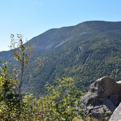
A 60-acre parcel perched on the summit of the Northeast's highest peak is surrounded by the extensive 750,000-acre White Mountain National Forest. On a clear day, views from the 6,288-foot summit extend beyond New Hampshire as far as 130 miles to Vermont, New York, Massachusetts, Maine, Quebec, and the Atlantic Ocean. The Visitor Center at the top of Mount Washington is open daily, during the summer/fall, Sadly The Tip Top House is closed now. The Sherman Adams building, houses The Sherman Adams Visitor Center, a cafeteria, restrooms, gift shops, the Mount Washington Observatory, and its museum. Mount Washington is the central, highest summit of an alpine mountain massif called the Presidential Range where many peaks are named after former U.S. presidents. Other high peaks -- Mounts Clay, Jefferson, Adams, and Madison. Mount Washington has earned the title of "Home to the Worst Weather in the World". in 1934 the Mount Washington Observatory recorded a wind speed of 231 mph - the world record for most of the 20th century and still the record for a measured speed, not produced by a tropical cyclone. parking: ample parking there if you reach early ;) Fee: Car+driver- $ 45 (Oct-2022) Extra person: $20 PP children- $9 PP
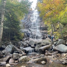
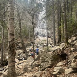
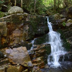
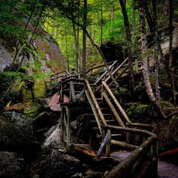
I am an avid hiker and was thrilled to try out the White Mountains. Unfortunately, we only had one day while passing through but made sure to make it worth while. In the morning, we headed out on the Frankenstein Cliff and Arethusa Falls trails. I was stunned to see some reviews here saying the area offered no challenging hiking trails. Those individuals obviously didn't try Frankenstein Cliff. I have hiked in national parks all across the US, including popular Bryce and Zion. This trail was more challenging than any hike we did there! When we finished, my watch read "150 flights climbed". I will say that once we reached the top of the Cliff, it was before noon and still foggy so the view was not worth it. I would recommend skipping this trail unless you can guarantee great visibility. The Arethusa Falls trail was not challenging and came with a beautiful view. Wish we could have spent more time at the falls. For experience hikers and both trails combined, it took us 5 hours with hardly any long breaks. Can't wait to visit again!

Mount Washington is the tallest peak in the Eastern United States that isn't in North Carolina. *cough* Mount Mitchell: https://www.yelp.com/biz/mount-mitchell-state-park-burnsville?hrid=pHsp0Hlz8QTUH-IeYtpNHw *cough* I've seen those "This car climbed Mount Washington" bumper stickers for years and targeted Mount Washington on this trip to acquire one of my own. I should have read the rules - they don't allow conversion vans to make the trip. It's completely logical and the rule is designed for safety. The problem is that the additional weight of all the conversion equipment - microwave, solar panels, power inverter, bed, cabinets, toilet, water, etc. - puts additional strain on the transmission as you're descending the mountain. This means that the transmission can't solely slow you down, so now you're riding on the brakes. And if you're using the brakes a lot, they'll overheat. And when they overheat, they fail. It's happened often enough that they put this rule in place. Believe me, they'd love to take your money and have you drive the mountain! But they don't want to rescue you when your brakes melt and seize half-way down the mountain. So there will be no "This car climbed Mount Washington" bumper sticker today. *sad face* I arrived at the mountain late enough that there wasn't room on their van tour or the cog railway. So that just means that I need to return. The base camp has restrooms, a huge gift shop, a restaurant, picnic areas and plenty of parking. I'll be back here and I'll plan to arrive earlier so I can ride the railroad to the summit. [Review 18548 overall - 99 in New Hampshire - 2070 of 2022.]

Mount Washington in Coos County, New Hampshire is a unique experience. While I only lived in New Hampshire for little over a year, I had the opportunity to visit Mount Washington on several occasions. On one of my visits was the Annual Run/Walk/Bike up Mount Washington. I couldn't believe people were actually running up this Mountain. My car had a tough enough time climbing up! It's definitely worth a trip. Beautiful scenery even if it is cloudy up top.


Awe-inspiring. Mount Washington is the real deal. At 6288' it is the tallest peak in New England. Hike it. Drive it. Cog Railway it. Have your pick. I chose to hike this beast. I'd been working on hiking all 48 peaks in New Hampshire at four thousand feet and above. This was the pinnacle summit to close out my journey. My hike up this peak was so unique compared to the treks up the others. I took the Ammonoosuc Ravine Trail up and the Jewell Trail down... passed waterfalls, sweeping views, glacial rock, cascades, lakes, huts, and so much more. I also experienced 20 degree wind chill (in August), fog that swallowed visibility, and loads of people who were simply not prepared for the trip. Beautiful but grueling. Rewarding but challenging. I came prepared... lots of water and snacks, sturdy boots, layers upon layers of clothing, and a camera of course. The prep was worth it. I was as comfortable as you can be in the tree-less alpine zone with whipping winds and heavy cloud cover up top. Over-prepare, be realistic with your ability to reach the top on foot, put safety first and you'll set yourself up for success. The summit was an interesting place to be. A healthy mix of day hikers, Appalachian Trail thru-hikers, and tourists (in all sorts of dress... can't say I envied the folks in shorts cowering against the freezing wind chill while I wore 2-3 layers and ski gloves). Gift shop, food court, observatory, and so much more. A line of people waiting to take a picture with the summit sign. Really cool that everyone has the opportunity to make it up top, no matter the vehicle that gets them there. Truly a natural wonder.

We visited Mount Washington because we were in the area. Unfortunately because we went out of season the museum was not open but it was still a good experience to visit the top. While on the summit you are able to visit the museum, eat at a snack shop and you are also able to visit the souvenir shop if you wish. We were able to stand on the observatory deck and catch all the different sides of the mountain, we could see Vermont, Maine , Canada and obviously New Hampshire. Luckily we visited on a day where visibility was awesome as you will see with some of our pics. We took the railway up and it was a nice slow guided tour ride. Definitely a great experience, I highly recommend it if in the area, but make sure you dress warmly.

A lot of negative press due to wind and no guard rails... it isn't for everyone but I'd highly recommend it. They close in October for a reason, so if you take it slow it isn't bad. We're not talking 3rd world, there are plenty of warnings that make it seem worse than it is. There is one section that wasn't paved and be sure to read the folder they give you. Please move out of the way if you have too many people piling up behind you, as there are several pull over points along the way, and it's a great idea to get good photos of the vegetation

Overall my trip on the up to the summit of Mount Washington via the Cog railway was okay, but that was mainly due to weather, which is no fault of the train operators themselves. The trip up was cool, I loved the factual narration given to us by Terry, but we couldn't see all that much due to the fogginess of the car's windows which is expected in rainy conditions. Overall, my 3 star review lies in the lack of transparency on Mt Washington Cog Railway's/Mount Washington National Park (association?) part. I purchased my tickets a couple days in advance, but when we arrived at the station to pick up our tickets from willcall, there was absolutely no way of knowninf what the weather at the summit would be like. I've taken cable cars and vernaculars to summits in other places and I feel like there's always a screen or a live stream picturing the weather/view at the summit for "day of" travelers to decide whether or not they want to partake in that particular day. Overall I'm not angry, however in addition to the lack of transparency the website for the railway (which may or may not be run by the same people as the national forest, however I'm assuming not considering one is probably nationally versus privately owned) in a round-about, 14-clicks-later fashion, mentioned that the visitor center wasn't even open after Columbus Day (re: Indigenous People's Day as it should be coded on the website especially seeing as this land in particular was occupied by Natives prior to being settled) and that even if it was, that you ALSO have to buy a ticket for said visitor center, which is kindof shady. If the information was made available to the railway, it should've been easily accessible on the front page, versus within a (!) button hiding within ticketing info. The weather was crappy, foggy, freezing and rainy, which is fine, I understand that weather at this altitude is crazy and is much different than down below, but they really hid on their website that the visitor center was closed, ESPECIALLY as a means of shelter from the rain and cold. Overall that should be a "warning message" when you buy your tickets after the aforementioned closing date. Even if not open for the tourist access, more so literally for crazy weather shelter. Essentially we all took a couple pictures and then hung out for an hour in the one coach that they had at the summit because it was literally pouring. Again, not mad about the weather, mad that they closed the visitor center a week before the train was closed. Like why not wait one more week, when the last day for trips was October 18th? It literally makes no sense as to why they couldn't hold on for a couple more days. Overall I'd love to come again on a nicer day to be able to see the wonderful views, but I'm very disappointed about the lack of transparency about the visitor center closing.

Hiked up through Lionhead trail (4 miles) and down through Boott Spur (5 miles) trail. The trails are all rocky, so it takes longer than you think. In the middle of June, there is no snow left, that was nice. Lionhead trail is more popular and saw many people, but almost nobody on Boott Spur. Actually Boott Spur is more scenic and peaceful, just a bit longer. It is ridiculous to see normal people (who drove or took train) at the top. I wish there was only hike access to the top for the solitude.

Amazing! Thats one word to describe the Trinity Heights Connector on Mount Washington. Anybody who has been to NH would agree with me that its a feast for the eyes and soul during fall. Its lush, with thick foliage, mountains, lakes, and clear area views at many spots. There was so much to do there but we were on a clock. So chose to experience the Cog Railway (With my weak lungs, I wouldn't have been able to the hike anyway) It was misty and foggy when we left NH and was kinda worried but lady luck smiled on us and it turned out to be the perfect sunny but not stingy sunny. It was about a 30 min ride up. With constant commentary on the railway, the height it is going, history, use etcetc everything that can put one to sleep(;).... lol... yes and no... the history part was really interesting for me... as the other parts on mechanics must have interested the others... but he spoke non stop and that's something ! On top was the most amazing scenery. The clouds below u and just green mountains all around. At one point everyone and everything around seize to exist.... that kind of beauty. There is a cafe on top and everyone squeezed in as it got real chilly. Ones who cane prepared with coats, caps , gloves took their coffee and stood out- cause thats where u need to be . I think they gave us about an hour to spend before they come to collect us. U can miss and take the next one down provided it is not already full with the valid ticketed passengers. It was the last train of the day so we didn't have the option of waiting. It should be noted here that u can drive up to the top, almost to the top, but the Railroad experience is unique. The driver had explained that 4 states borders are visible... to me it was all just mountains, clouds, and my effort to try to capture my excitement in a camera so I would never forget it .... read more


We took the cog railway to the top of Mount Washington during a snow blizzard, even though it was end of May!!!! Talk about its crazy weather!!! Luckily the service station was a solid indoor space with proper heat and protection. All guests were surviving well despite the blizzard. There's a gift shop, a cafe, lots of sitting space, registration booth for hikers, and a museum. The cafe had hot and cold drinks and some food options. The gift was had plenty of nice souvenirs and MW merchandises. But the indoor space in general was little bit messy. The contracted post office was a nice surprise. We dropped couple of postcards to ourselves and friends from top of the mountain. But due to the blizzard we couldn't do any other activity like going to the observatory. read more


Visited the summit by Cog railroad. It was Memorial Day weekend and it was snowing in the mountain. Never would have thought of that. I did bring hat and gloves just in case but I did see people coming in full gear (snow suit and shoes). I didn't get to see much because the wind was howling and snow was hitting my face. Wind guest was up to 40mph? Ran out to take a picture with the landmark and ran back in. Still pretty fun for me though. Hopefully next time we visit, it will be a clear weather. read more


Fantastic bucket list experience! You can arrive by car but we rode the cog gear rail up the mountain and really enjoyed that experience. The rail provides a close up look of the different mountain zones and get some history and humor thrown in for free. There isn't much explanation of anything on the top of the mountain other than you can tell there are some weather related equipment around there. Most of it is no longer used or working. It was cloudy the day we visited but still worth it. We even witnessed and marriage proposal at the high point marker where everyone gets in line to take a selfie. read more

A 60-acre parcel perched on the summit of the Northeast's highest peak is surrounded by the extensive 750,000-acre White Mountain National Forest. On a clear day, views from the 6,288-foot summit extend beyond New Hampshire as far as 130 miles to Vermont, New York, Massachusetts, Maine, Quebec, and the Atlantic Ocean. The Visitor Center at the top of Mount Washington is open daily, during the summer/fall, Sadly The Tip Top House is closed now. The Sherman Adams building, houses The Sherman Adams Visitor Center, a cafeteria, restrooms, gift shops, the Mount Washington Observatory, and its museum. Mount Washington is the central, highest summit of an alpine mountain massif called the Presidential Range where many peaks are named after former U.S. presidents. Other high peaks -- Mounts Clay, Jefferson, Adams, and Madison. Mount Washington has earned the title of "Home to the Worst Weather in the World". in 1934 the Mount Washington Observatory recorded a wind speed of 231 mph - the world record for most of the 20th century and still the record for a measured speed, not produced by a tropical cyclone. parking: ample parking there if you reach early ;) Fee: Car+driver- $ 45 (Oct-2022) Extra person: $20 PP children- $9 PP read more


I am an avid hiker and was thrilled to try out the White Mountains. Unfortunately, we only had one day while passing through but made sure to make it worth while. In the morning, we headed out on the Frankenstein Cliff and Arethusa Falls trails. I was stunned to see some reviews here saying the area offered no challenging hiking trails. Those individuals obviously didn't try Frankenstein Cliff. I have hiked in national parks all across the US, including popular Bryce and Zion. This trail was more challenging than any hike we did there! When we finished, my watch read "150 flights climbed". I will say that once we reached the top of the Cliff, it was before noon and still foggy so the view was not worth it. I would recommend skipping this trail unless you can guarantee great visibility. The Arethusa Falls trail was not challenging and came with a beautiful view. Wish we could have spent more time at the falls. For experience hikers and both trails combined, it took us 5 hours with hardly any long breaks. Can't wait to visit again! read more


Mount Washington is the tallest peak in the Eastern United States that isn't in North Carolina. *cough* Mount Mitchell: https://www.yelp.com/biz/mount-mitchell-state-park-burnsville?hrid=pHsp0Hlz8QTUH-IeYtpNHw *cough* I've seen those "This car climbed Mount Washington" bumper stickers for years and targeted Mount Washington on this trip to acquire one of my own. I should have read the rules - they don't allow conversion vans to make the trip. It's completely logical and the rule is designed for safety. The problem is that the additional weight of all the conversion equipment - microwave, solar panels, power inverter, bed, cabinets, toilet, water, etc. - puts additional strain on the transmission as you're descending the mountain. This means that the transmission can't solely slow you down, so now you're riding on the brakes. And if you're using the brakes a lot, they'll overheat. And when they overheat, they fail. It's happened often enough that they put this rule in place. Believe me, they'd love to take your money and have you drive the mountain! But they don't want to rescue you when your brakes melt and seize half-way down the mountain. So there will be no "This car climbed Mount Washington" bumper sticker today. *sad face* I arrived at the mountain late enough that there wasn't room on their van tour or the cog railway. So that just means that I need to return. The base camp has restrooms, a huge gift shop, a restaurant, picnic areas and plenty of parking. I'll be back here and I'll plan to arrive earlier so I can ride the railroad to the summit. [Review 18548 overall - 99 in New Hampshire - 2070 of 2022.] read more


2 years ago
Mount Washington in Coos County, New Hampshire is a unique experience. While I only lived in New Hampshire for little over a year, I had the opportunity to visit Mount Washington on several occasions. On one of my visits was the Annual Run/Walk/Bike up Mount Washington. I couldn't believe people were actually running up this Mountain. My car had a tough enough time climbing up! It's definitely worth a trip. Beautiful scenery even if it is cloudy up top. read more


We took the Cog Railway up. We saw hikers and BMX performers filming on the way up. The view in incredible. We couldn't believe they had a post office, so we purchased a few postcards, stamps and mailed them off to family and friends. Unfortunately, no one ever received them /: read more


Awe-inspiring. Mount Washington is the real deal. At 6288' it is the tallest peak in New England. Hike it. Drive it. Cog Railway it. Have your pick. I chose to hike this beast. I'd been working on hiking all 48 peaks in New Hampshire at four thousand feet and above. This was the pinnacle summit to close out my journey. My hike up this peak was so unique compared to the treks up the others. I took the Ammonoosuc Ravine Trail up and the Jewell Trail down... passed waterfalls, sweeping views, glacial rock, cascades, lakes, huts, and so much more. I also experienced 20 degree wind chill (in August), fog that swallowed visibility, and loads of people who were simply not prepared for the trip. Beautiful but grueling. Rewarding but challenging. I came prepared... lots of water and snacks, sturdy boots, layers upon layers of clothing, and a camera of course. The prep was worth it. I was as comfortable as you can be in the tree-less alpine zone with whipping winds and heavy cloud cover up top. Over-prepare, be realistic with your ability to reach the top on foot, put safety first and you'll set yourself up for success. The summit was an interesting place to be. A healthy mix of day hikers, Appalachian Trail thru-hikers, and tourists (in all sorts of dress... can't say I envied the folks in shorts cowering against the freezing wind chill while I wore 2-3 layers and ski gloves). Gift shop, food court, observatory, and so much more. A line of people waiting to take a picture with the summit sign. Really cool that everyone has the opportunity to make it up top, no matter the vehicle that gets them there. Truly a natural wonder. read more


We visited Mount Washington because we were in the area. Unfortunately because we went out of season the museum was not open but it was still a good experience to visit the top. While on the summit you are able to visit the museum, eat at a snack shop and you are also able to visit the souvenir shop if you wish. We were able to stand on the observatory deck and catch all the different sides of the mountain, we could see Vermont, Maine , Canada and obviously New Hampshire. Luckily we visited on a day where visibility was awesome as you will see with some of our pics. We took the railway up and it was a nice slow guided tour ride. Definitely a great experience, I highly recommend it if in the area, but make sure you dress warmly. read more


2 years ago
A lot of negative press due to wind and no guard rails... it isn't for everyone but I'd highly recommend it. They close in October for a reason, so if you take it slow it isn't bad. We're not talking 3rd world, there are plenty of warnings that make it seem worse than it is. There is one section that wasn't paved and be sure to read the folder they give you. Please move out of the way if you have too many people piling up behind you, as there are several pull over points along the way, and it's a great idea to get good photos of the vegetation read more

4 years ago
Overall my trip on the up to the summit of Mount Washington via the Cog railway was okay, but that was mainly due to weather, which is no fault of the train operators themselves. The trip up was cool, I loved the factual narration given to us by Terry, but we couldn't see all that much due to the fogginess of the car's windows which is expected in rainy conditions. Overall, my 3 star review lies in the lack of transparency on Mt Washington Cog Railway's/Mount Washington National Park (association?) part. I purchased my tickets a couple days in advance, but when we arrived at the station to pick up our tickets from willcall, there was absolutely no way of knowninf what the weather at the summit would be like. I've taken cable cars and vernaculars to summits in other places and I feel like there's always a screen or a live stream picturing the weather/view at the summit for "day of" travelers to decide whether or not they want to partake in that particular day. Overall I'm not angry, however in addition to the lack of transparency the website for the railway (which may or may not be run by the same people as the national forest, however I'm assuming not considering one is probably nationally versus privately owned) in a round-about, 14-clicks-later fashion, mentioned that the visitor center wasn't even open after Columbus Day (re: Indigenous People's Day as it should be coded on the website especially seeing as this land in particular was occupied by Natives prior to being settled) and that even if it was, that you ALSO have to buy a ticket for said visitor center, which is kindof shady. If the information was made available to the railway, it should've been easily accessible on the front page, versus within a (!) button hiding within ticketing info. The weather was crappy, foggy, freezing and rainy, which is fine, I understand that weather at this altitude is crazy and is much different than down below, but they really hid on their website that the visitor center was closed, ESPECIALLY as a means of shelter from the rain and cold. Overall that should be a "warning message" when you buy your tickets after the aforementioned closing date. Even if not open for the tourist access, more so literally for crazy weather shelter. Essentially we all took a couple pictures and then hung out for an hour in the one coach that they had at the summit because it was literally pouring. Again, not mad about the weather, mad that they closed the visitor center a week before the train was closed. Like why not wait one more week, when the last day for trips was October 18th? It literally makes no sense as to why they couldn't hold on for a couple more days. Overall I'd love to come again on a nicer day to be able to see the wonderful views, but I'm very disappointed about the lack of transparency about the visitor center closing. read more


6 years ago
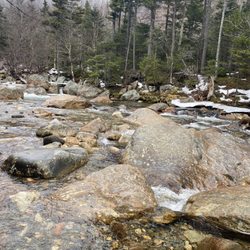
Hiked up through Lionhead trail (4 miles) and down through Boott Spur (5 miles) trail. The trails are all rocky, so it takes longer than you think. In the middle of June, there is no snow left, that was nice. Lionhead trail is more popular and saw many people, but almost nobody on Boott Spur. Actually Boott Spur is more scenic and peaceful, just a bit longer. It is ridiculous to see normal people (who drove or took train) at the top. I wish there was only hike access to the top for the solitude. read more


4 years ago
By policies which you can't find anywhere to familiarize our 19' van was not allowed to enter and turned around after entire night of wait. Very limited information at the place about limitations work hours, no garbage cans in the area. No internet access. Prices are sky roofing: Vehicle and driver 45$ Extra Adults 20$, Kids 5 and up 9$. Very frustrating. No pedestrians no bicycles are allowed either. The nature itself is beautiful, but family owned business employees lacks manners and do not even let us talk explaining how our van built and capable driving the mountain. Very very disappointing. read more


3 years ago
7 years ago
This is a cool (literally) place! As the highest point in the eastern US at 6288ft, you are sure to enjoy the nature and views on Mount Washington. You can get to the summit by hiking, car, or cog rail - no matter how you get there, just get there! We took the cog rail and were given an hour to explore the summit and take in the views. read more


7 years ago
Too beautiful. The climb up is amazing, scenic and breathtaking. Totally worth it. The entry fee is $31 per car includes drives, and $9 per passenger. Some people may find it expensive, but trust me the drive, the view, the climb up there, the trails and every single memory you'll make is totally worth it. I'd highly recommend you to visit during the fall, the colors are amazing. We visited on second weekend of October. read more


What a beautiful hike! This was my 2nd hike (1st was monadnock) and I went with my bf and 2 of our friends (all experienced hikers except for me). I wore sneakers because I don't own hiking boots yet- and after this trip I'll definitely purchase a pair! My feet were fine in sneakers but I think hiking boots would give me more stability/traction. We started at 10am and it took us 4 hours to summit. The hike up wasn't difficult. A bit rocky at the top so we scrambled up for the last mile or so. We took Tuckerman's trail halfway up and then Lion's head for the rest of the way. We hung out at the top for about 2 hours and then headed back down. I must say- it was a little weird that so many people drive up there. It was packed full of non-hikers and they were quite interested in asking us questions about the hike.. The trip down was a different story! We took the Nelson Craig trail (5 miles) and we didn't reach the bottom until 9pm (left at 4). We had heard that this trail was more scenic so we thought it was a good idea. I felt fine for the 1st 3 miles but I began to get verrryyy tired towards the end. This trail is very steep and there are a lot of rocks to slide down. I'm very short so it was kind of difficult for me. Since we left so late the sun set and we finished the last 1.5 miles in darkness (which was actually fun). Also, the trail ended up not being as scenic as the way up :/. My legs were jelly by the end of the hike but I was sooo happy! I would definitely recommend the trails we took up. Next time I'll be taking a different trail back down! read more


16 years ago
The world's worst weather The summit has experience the highest wind ever recorded, 231 MPH. It was probably higher but the instruments broke and unofficial reports actually go higher. The average wind speed between Dec and March is 55 MPH and hurricane force winds occur 2 out of every 3 days. Six feet of ice have been known to form overnight. The average winter temp is 5 degrees and it has hit -50. Of course the high winds make it feel a bit nippier. Over 200 inches of snow fall every year and the buildings have been reinforced to withstand 300 knots winds. Most have huge chains to hold them down. I don't know if the summit of Mount Washington has the worse weather in the entire world like they claim but it sure does get feisty up there. There are three ways to get to the top, The easiest is to take the cog railroad. Relaxing and fun. The second is to drive up the auto road. You better not be afraid of heights and you better have some good brakes. The third is to hike up. Several paths lead to the summit but you damn well better be sure you know what you are doing if you try. Hundreds of hikers and skiers have died up here and a few years ago a fellow that conquered Everest perished in a sudden storm. His last words before leaving was, "how hard can a 6,000 foot mountain be"? Apparently he found out. I have been on the top when the fog was so thick that you literally couldn't see ten feet in front of you. These of course are very dangerous hiking conditions. When I went up a few days ago it was crystal clear and the visibility was over one hundred miles. Absolutely stunning views in all directions and the landscape reminds me of the pictures from Mars. On top there is a little restaurant, some very cool weather equipment and data and of course a gift store to buy crummy t-shirts and trinkets. But the real attraction is being outside in the elements. The summit of the mountain is one of my favorite places in the whole world and you never know what it's going to be like up there. A few years ago some friends and I went up and when we left the bottom it was 65 degrees and sunny. Once on top the weather changed and it was 20 degrees with a hundred mile per hour breeze and ice forming rapidly. And this was in August. A great place to see at least once and even better if you go more than once. It doesn't matter how you get up, the summit is always awe inspiring. Just be sure you know what you are getting into and never stop respecting the mountain. Or you just might end up with your name on one of the little crosses scattered about. The little crosses with the names of dead people. http://www.youtube.com/watch?v=czazfwci1vE&feature=related read more


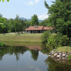
Mount Washington is the highest point in the northeastern U.S. at 6288 feet elevation. Even at that elevation it has an alpine zone starting at just abut 4000 feet. It's rocky (understatement) all the way. There is no such thing as level footing. I've climbed 14ers in Colorado and California and yes, yes, they have the altitude and lack of oxygen -- no doubt about that -- but Mount Washington presents its own obstacles and wonders that are just as worthwhile as any 14,000 foot summit. Mount Washington -- she's majestic. So majestic that I keep climbing her, now for the annual Seek the Peak hikeathon in mid July to benefit the Mount Washington Observatory. Please do check it out: seekthepeak.org and participate if you're up to the task or donate towards the cause. It's the only 4000 footer (a mountain of 4000 feet or higher in elevation) in NH which has a driveable road to the top. As such, it also has ammenities such as a cafeteria, restrooms, water, gift shop, museum, and observatory at the top, open during the late Spring, Summer, and early Fall time periods. Note that the road is operable between sometime in May and October based on snow removal conditions. Also note that there is nothing open at the top in the winter if you prepare for a winter hike to the top. No, you can't show up at the Observatory and hope they'll let you in, though it is manned all year long. There are several ways to enjoy the queen of the White Mountains. 1) You can drive up via the auto road: mtwashingtonautoroad.com for rates at this posting of $25 for car and driver with an additional $8 for each adult and less for children. 2) You can opt for the cog rail: thecog.com for a rate for adults most of the year at $62 each roundtrip. 3) You can hike if you're in physical shape and use common sense to take the 10 hiker essentials, etc. Just remember, if it's 80 degrees in the valley, it WILL NOT be 80 at the top. It can be quite cold, windy, foggy, etc. so be prepared. I could go on and on but you can read here: mountwashington.org/abou... I've gotten to the top all 3 ways and am an avid lover of hoofing it. There are several trails. Two of them I've taken have trailheads near the cog rail: Ammonoosuc Ravine Trail and the Jewell Trail (going up the first and down the latter is a nice loop ending at the same trailhead and parking lot). They have a bit less elevation gain than some others I'll detail below. Other choices from the Applachian Mountain Club (AMC) Joe Dodge Lodge (and a great place to stay before and/or after the hike) are the popular Tuckerman's trail and the Lion's Head trail, both starting out from the Tuckerman's trail. Do read up on them and their steepness to make your decisions. I've taken both up and Lion's Head down. I've also taken Boott Spur trail down but boy! was it ever longer than the others and not gradual as I had thought it would be. All trails except for Boott Spur took me about 4 to 4.5 hours one way up and just slightly less coming down due to the steepnness. And, no, I'm not the fastest hiker and wouldn't win any contests but it was a sufficient enough pace. Both the Lion's Head and Tuckerman's trail are about 8.2 miles round trip with 4200 feet elevation gain. So, using the standby formula of 2 miles per hour plus 1/2 hour for each 1000 feet of elevation gain, that's about right for my pace. read more


7 years ago
Great hike. We have done this several times from tuckermans & Huntington Ravine trail. Be prepared as the elements change quickly. We turned around last year when winds reached 70mph. read more


12 years ago
FIRST THINGS FIRST...I climbed this mountain with my own 2 legs, not my car. Not sure I can take the reviews that involve a car seriously! Meanwhile, back at the ranch.... What a fantastic, yet challenging mountain to climb! I made the trek with a group of 3 others including a best friend. We set out around 7 or 8 am to get an early start. Stopped at the dunkin donuts close to the base to fuel up. It was an amazingly beautiful 2012 late summer day. The weather all week hadn't been that great, but this day was fantastic.. -lots of pictures taken, lots of scenery to ooh and ahh, some crazy climbing up.... ...we made it to the summit in 4 hours...ppppheeeeew Took a good 45 minute- 1hr. rest inside to rest, eat and finally take some summit pics (oh, and buy a few souvenirs)....and on back down we went. OK, the way down is WAY harder..mainly because your muscles are exhausted and allowed to cool down up top, which isn't the greatest thing I might add. Going down also took us 4 hours, but was extremely tough particularly for my buddy. We had plans to train a LOT more and get conditioned for this climb--if you don't train a bunch beforehand--you will be sore I promise you! So, up and down in 8 hours. Lots of pics taken--amazing views and sense of accomplishment. Very sore leg muscles. My buddy was really feeling it and managed to say that he "will NEVER do this climb again!". We had a blast and I would absolutely climb this mountain again in an instant! read more


Just gorgeous! Spectacular views of the White Mountains and the auto road is super fun. Just make sure you are comfortable with mountain driving as this is super steep and can be stressful even for experienced drivers. They charge per car plus passengers but once you're at the top, you can hike, buy things at the gift shops, purchase food, and take lots of amazing pictures. When coming down, some people aren't super comfortable with the steep roads even in 1st gear, and they brake too much. Pull over and cool off your brakes! Don't ride the brakes any more than necessary! Just safer for all of us. That being said, stay calm and enjoy the gorgeous scenery. Well worth it! read more

9 years ago
Well worth the wear & tear on the body or car to be on this glorious summit, get there before noon as it gets really crowded! read more


15 years ago
10 years ago
5 years ago
8 years ago
Page 1 of 2
More info about Mount Washington
Sargent's Purchase, NH 00176
Directions
Hours
Outdoor Amenities
Ask the Community - Mount Washington
Review Highlights - Mount Washington


Mount Washington - hiking - Updated July 2026
Best of Sargent's Purchase
People found Mount Washington by searching for…
Campgrounds in Sargent's Purchase, New Hampshire
Things to Do in Sargent's Purchase, New Hampshire
Hiking Trails With Waterfalls in Sargent's Purchase, New Hampshire
Tours in Sargent's Purchase, New Hampshire
Waterfalls and Swimming Holes in Sargent's Purchase, New Hampshire
Parks in Sargent's Purchase, New Hampshire
Easy Hikes in Sargent's Purchase, New Hampshire
Sunset View in Sargent's Purchase, New Hampshire
Scenic Drive in Sargent's Purchase, New Hampshire
Scenic View in Sargent's Purchase, New Hampshire
Attractions in Sargent's Purchase, New Hampshire
Visitor Centers in Sargent's Purchase, New Hampshire
Things to Do on a Rainy Day in Sargent's Purchase, New Hampshire
Dog Friendly Hiking Trails in Sargent's Purchase, New Hampshire
Scenic Overlook in Sargent's Purchase, New Hampshire
Playgrounds in Sargent's Purchase, New Hampshire
Off Road Trails in Sargent's Purchase, New Hampshire
Waterfalls in Sargent's Purchase, New Hampshire
Lookout Points in Sargent's Purchase, New Hampshire
Beautiful Views in Sargent's Purchase, New Hampshire
Photo Spots in Sargent's Purchase, New Hampshire
Tourist Attractions in Sargent's Purchase, New Hampshire
Browse Nearby
BEST of Sargent's Purchase, New Hampshire Things to Do near Mount Washington
BEST of Sargent's Purchase, New Hampshire Scenic View near Mount Washington
BEST of Sargent's Purchase, New Hampshire Restaurants near Mount Washington
BEST of Sargent's Purchase, New Hampshire Coffee near Mount Washington
BEST of Sargent's Purchase, New Hampshire Campgrounds near Mount Washington
BEST of Sargent's Purchase, New Hampshire Museums near Mount Washington
BEST of Sargent's Purchase, New Hampshire Breakfast near Mount Washington
BEST of Sargent's Purchase, New Hampshire Ski Resorts near Mount Washington
BEST of Sargent's Purchase, New Hampshire Sledding near Mount Washington
Browse Brands
Browse Articles
People who viewed Mount Washington also viewed
Kancamagus Highway
43 reviews
Mount Lafayette
3 reviews
Green Hills Preserve / Pudding Pond
1 review
Thompson Falls
1 review
Franconia Notch State Park
53 reviews
Thorne Pond Conservation Area
1 review
North Ridge Mountain Guides
4 reviews
Artists Bluff
4 reviews
Muddy Paw Sled Dog Kennel
48 reviews
Champney Falls Trail
2 reviews