Ripley Falls Photos


You might also consider
More like Ripley Falls
Recommended Reviews - Ripley Falls
Start your review...

16 years ago
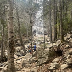
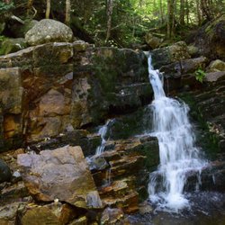
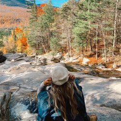
Rocks roots and ruts Ripley Falls is a 100 foot high waterfall that takes on several different personalites. In the late summer and fall it is a quiet and well behaved little falls. A nice place to hike out with the kids, dogs and grandpa and have a picnic. However in the spring when the snows in the mountains start to melt it becomes raging torrent. The noise is actually deafening. In the winter in frequently freezes and huge icicles hang off it. The actually hike to get to the falls is only a half a mile and in the proper conditions is quite easy. However the trail frequently is wet and broken and ice forms easily so it's a bit more difficult than it looks. A woman I met on the trail said that this trail has a reputation as a leg breaker because of all the loose rocks and wet and slippery roots. Of course many other trails connect so you can hike for days if you want. The falls is just a starting point to far more rugged and interesting places and few people turn back here. Ripley Falls is just one of the many waterfalls in the area and a pleasant little diversion from more strenuous hiking. In the spring it is pretty impressive but it's still but still nice even in periods of low water. A nice spot to visit as long as you don't have you expectations too high. read more


Regardless of season, a fun waterfall to chillax or be adventurous. I've snow hiked here a couple winters ago to take some nature snow landscape photos. I managed to not fall off the hiking trail in foot deep snow and made it back here this summer for some waterfall repelling. Waterfall repelling was a fun experience. Repelling next to the falls that is. I still got soaked in 55 degree water. read more


9 years ago
13 years ago
11 years ago
13 years ago
9 years ago
More info about Ripley Falls
Crawford Notch State Park
Rt 302
Fabyan, NH 03583
Directions
Hours
Outdoor Amenities
Ask the Community - Ripley Falls


Ripley Falls - hiking - Updated May 2026
Best of Fabyan
People found Ripley Falls by searching for…
Hiking Trails With Waterfalls in Fabyan, NH
Waterfalls and Swimming Holes in Fabyan, NH
Hiking With Kids in Fabyan, NH
Dog Hiking Trails in Fabyan, NH
Places to Take Pictures in Fabyan, NH
Hiking Trails Kid Friendly in Fabyan, NH
Dog Friendly Trails in Fabyan, NH
Off Leash Dog Hikes in Fabyan, NH
People who viewed Ripley Falls also viewed
Bald Mountain/artists Bluff
10 reviews
Champney Falls Trail
2 reviews
The Basin
29 reviews
Glen Ellis Falls
19 reviews
Cannon Mountain Aerial Tramway
23 reviews
White Mountain National Forest
5 reviews
Franconia Notch State Park
53 reviews
Albany Covered Bridge
5 reviews
Franconia Notch Stables
22 reviews
Profile Lake
1 review