Grafton Notch State Park Photos


You might also consider
More like Grafton Notch State Park
Recommended Reviews - Grafton Notch State Park
Start your review...

Reviews With Photos
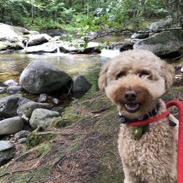
What a lovely way to spend a few hours and enjoy nature. This park has several picnic areas and pit stops with small natural attractions and paths. Their main hiking trails can connect to parts of the Appalachian trail. Just visiting all of the smaller stops, we were able to spend about 2 hours in the park. We really enjoyed the Spruce Meadow Picnic area. We took our dogs and were able to follow the signs for the park very easily. Great views and pictures are awaiting at Grafton Notch!

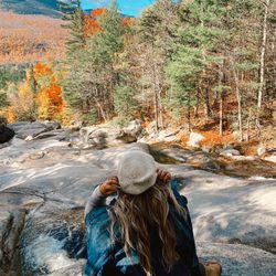
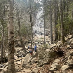
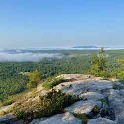
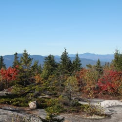
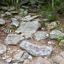
I really love this park. Grafton Notch includes some gorgeous hiking and fun exploring. I recently climbed Old Speck Mountain, the fourth highest peak in Maine, via the AT. It was beautiful - I must add, it was a pretty lengthy hike. We went on a sunny day in August, which made the forest light up and the mosses glow - it was truly beautiful. There is a waterfall on the trail, as well as plenty of mushrooms, flowers, and berries. I'd rate this trail as moderate - it is not particularly difficult or intimidating in any spots. Last year I did the Eyebrow Trail, which breaks off from the AT .1 miles from the parking lot. It was gorgeous and a bit more thrilling than the AT. The summit includes a fire tower, which is a bit scary to climb up, I must say! However, I was glad I did, and it was a lot of fun to get the views (it's a wooded summit). Also gorgeous in this park are Moose Cave and Screw Auger Falls. Very beautiful, scenic areas that really make you appreciate Maine. This park is not frequented as much as the other somewhat nearby parks - this is what makes it so special. We passed only a few others on the trail, and we enjoyed the summit all to ourselves for fifteen minutes or so. Driving through the notch itself is beautiful - be sure to keep looking in your rearview mirror to catch glimpses of the amazing peaks!

Beautiful park, but some parts are terrifying as someone who's afraid of heights! I grew up in Connecticut and have explored a bunch of trails over the years. I was staying at a B&B in Bethel and thought that I could take a quick hike at Grafton Notch. Driving through the roads in late September was beautiful... some of the leaves had already begun changing colors. First stop was Moose Cave: a simple walk with a unique gorge. I probably visited the area for 20-30 minutes. Afterwards, I climbed the Eyebrow Loop Trail, which, oh boy... I saw the 2.2 miles round trip and thought, this is totally manageable, right? I should've done my due diligence and realized that this is a CHALLENGING trail with ladders and steel rungs! All I can say is that this is a very, very steep trail that is not for those who don't feel comfortable hanging over slight edges. I was basically trembling as I navigated from steel rung to steel rung. I thought the descent would be a lot easier, but unfortunately the steep nature of the trail made it almost as difficult. The good news is that the view at the top of the Eyebrow Loop was stunning, but I was so on edge that I couldn't really enjoy it! Definitely goofy of me to be afraid of heights and hiking challenging trails, but I'm glad that I made it through safely. If you're not afraid of heights, check out the Eyebrow Loop!

What a beautiful State Park! Plenty of sites and trails to hike so plan wisely. This should literally take you several weeks to see everything, and hike all the trails including parts of the AT! The trails that aren't part of the roadside stops should not be started in the mid afternoon or by those not accustom to steep, rutted, rocky and slick conditions as these trailed are not maintained for Easy Access.

Wow, Grafton Notch! What a gem my wife and I found as we traveled through the state park on our way to visit family at their camp in Lincoln Township, Maine. The park is located off route 26 near Newery, Maine. My wife and I, didn't have lots of time however my wife really loves water falls and, since it was her birthday we decided to stop and visit the Screw Auger Falls. What a fantastic site with the sun and fall trees full of vibrant colors in the background. So, if you are near Newery Maine and have some time to spare for visit to the falls or a day to hike, I would surely make your way to Grafton Notch. My wife and I will certainly visit again when we have a bit more time.

5 years ago
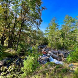
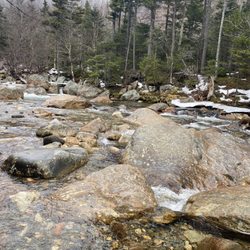
Grafton Notch State Park occupies 3,129 acres (1,266 hectares) surrounding Grafton Notch, the mountain pass between aldpate Mountain and Old Speck Mountain. The drive to it along ME 26 was beautiful, despite the intense and brutal heat on the day of our first visit. There are roadside turnouts for both Mother Walker Falls and Screw Auger Falls; the water flow at the falls was markedly curtailed due to the current drought conditions. You'll find signage that explains this area's glacial and geologic history. The trails leading to the waterfalls are short and well-marked, with uneven rock and forest flooring. Tip: Apparently Screw Auger Falls is so named because it looks as like someone took a giant auger and drilled large quantities of rock out of this quite sizable granite rock formation formation Tip: Dogs are allowed here for no additional fee. They're permitted throughout the park and on the trails; but not on the beaches I totally enjoyed everything I saw here on my first visit, and have already gone back a week ago. I expect to make visiting this very special destination a regular habit :-) read more


2 years ago
this is an absolutely beautiful state park; you'll find nothing like it in southern new england. the water was crystal clear, and it was perfect to explore in water shoes read more


What a lovely way to spend a few hours and enjoy nature. This park has several picnic areas and pit stops with small natural attractions and paths. Their main hiking trails can connect to parts of the Appalachian trail. Just visiting all of the smaller stops, we were able to spend about 2 hours in the park. We really enjoyed the Spruce Meadow Picnic area. We took our dogs and were able to follow the signs for the park very easily. Great views and pictures are awaiting at Grafton Notch! read more


I really love this park. Grafton Notch includes some gorgeous hiking and fun exploring. I recently climbed Old Speck Mountain, the fourth highest peak in Maine, via the AT. It was beautiful - I must add, it was a pretty lengthy hike. We went on a sunny day in August, which made the forest light up and the mosses glow - it was truly beautiful. There is a waterfall on the trail, as well as plenty of mushrooms, flowers, and berries. I'd rate this trail as moderate - it is not particularly difficult or intimidating in any spots. Last year I did the Eyebrow Trail, which breaks off from the AT .1 miles from the parking lot. It was gorgeous and a bit more thrilling than the AT. The summit includes a fire tower, which is a bit scary to climb up, I must say! However, I was glad I did, and it was a lot of fun to get the views (it's a wooded summit). Also gorgeous in this park are Moose Cave and Screw Auger Falls. Very beautiful, scenic areas that really make you appreciate Maine. This park is not frequented as much as the other somewhat nearby parks - this is what makes it so special. We passed only a few others on the trail, and we enjoyed the summit all to ourselves for fifteen minutes or so. Driving through the notch itself is beautiful - be sure to keep looking in your rearview mirror to catch glimpses of the amazing peaks! read more


6 years ago
Beautiful park, but some parts are terrifying as someone who's afraid of heights! I grew up in Connecticut and have explored a bunch of trails over the years. I was staying at a B&B in Bethel and thought that I could take a quick hike at Grafton Notch. Driving through the roads in late September was beautiful... some of the leaves had already begun changing colors. First stop was Moose Cave: a simple walk with a unique gorge. I probably visited the area for 20-30 minutes. Afterwards, I climbed the Eyebrow Loop Trail, which, oh boy... I saw the 2.2 miles round trip and thought, this is totally manageable, right? I should've done my due diligence and realized that this is a CHALLENGING trail with ladders and steel rungs! All I can say is that this is a very, very steep trail that is not for those who don't feel comfortable hanging over slight edges. I was basically trembling as I navigated from steel rung to steel rung. I thought the descent would be a lot easier, but unfortunately the steep nature of the trail made it almost as difficult. The good news is that the view at the top of the Eyebrow Loop was stunning, but I was so on edge that I couldn't really enjoy it! Definitely goofy of me to be afraid of heights and hiking challenging trails, but I'm glad that I made it through safely. If you're not afraid of heights, check out the Eyebrow Loop! read more


5 years ago
What a beautiful State Park! Plenty of sites and trails to hike so plan wisely. This should literally take you several weeks to see everything, and hike all the trails including parts of the AT! The trails that aren't part of the roadside stops should not be started in the mid afternoon or by those not accustom to steep, rutted, rocky and slick conditions as these trailed are not maintained for Easy Access. read more


Wow, Grafton Notch! What a gem my wife and I found as we traveled through the state park on our way to visit family at their camp in Lincoln Township, Maine. The park is located off route 26 near Newery, Maine. My wife and I, didn't have lots of time however my wife really loves water falls and, since it was her birthday we decided to stop and visit the Screw Auger Falls. What a fantastic site with the sun and fall trees full of vibrant colors in the background. So, if you are near Newery Maine and have some time to spare for visit to the falls or a day to hike, I would surely make your way to Grafton Notch. My wife and I will certainly visit again when we have a bit more time. read more


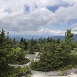
Dear Richard, One day my brother and I will climb Springer with you. We still have a couple of sections to go up here in the north and after catching Lyme from the tick in the Shenandoah last season I daresay I'm in no hurry to head south. I wonder if a fellow can get double Lyme. Doc sez I got the antibiotics in time, but still. The north has been kinder. At least in that regard. We finished the White sections maybe six years ago then flipped south and are about seven days below Harper's Ferry. Not right now. Right now I'm in California. Virginia is where our bootprint stops for the time being. We returned to the NH/Maine line this year, mostly slack-packing save for one stretch where we had two nights in shelters due to the distance between road crossings. This year was going to be a treat, a vacation also for our folks, day hikes and evenings with them. More like multiple tumbles, sadness and tears in my eyes from the insane grade, a hole in my sleeping pad thanks to one particularly brutal slide. The days were gorgeous (see photos), don't get me wrong, but these mountains make you work for it. These mountains take no prisoners. Here's the Useful part: 1) Many small towns for supply/resupply and friendly ppl to take you to the trailheads. 2) Many road crossings for miles in either direction so planning loops and day-hikes is easy peasy. 3) Grafton Notch parking lot is welcoming, though there was a ton of auto glass and it made me feel like I was back in Oakland for a second. 4) Grafton Notch south takes you over Old Speck Mountain then down into the Mahoosic Notch, a mile-long scramble over under around rocks the size of boxcars. No kidding. They don't call this the hardest mile on the Appalachian Trail for nothing. Nimble hikers can make it through in an hour. It took us over two. 5) Bald Pate Mountain is to the north of the notch parking lot. For day visitors I'd offer that this is the better of the two directions. Clear granite balds with views for days. Up and back with a little lunch and a sunny nap at the top is a lovely day well spent. 6) Watch your weather. On our second day the temperature at the top of Goose Eye was easily 30 degrees colder than the valley with rain and 50 mile an hour gusts blowing me off the bog bridges into unhappiness. We're about 1,100 miles complete; 1,000 more to go. We might need walkers by the time we get to you, Richard, but mark my words, we're a'coming. read more


8 years ago
9 years ago
17 years ago
15 years ago
10 years ago
15 years ago
More info about Grafton Notch State Park
1941 Bear River Rd
Newry, ME 04261
Directions
(207) 624-6080
Call Now
Hours
Indoor Amenities
Outdoor Amenities
Ask the Community - Grafton Notch State Park
Review Highlights - Grafton Notch State Park


Grafton Notch State Park - hiking - Updated May 2026
Best of Newry
People found Grafton Notch State Park by searching for…
Browse Brands
Browse Articles
People who viewed Grafton Notch State Park also viewed
Mount Blue State Park Campground
7 reviews
Coos Canyon
5 reviews
Black Mountain of Maine
8 reviews
ELC Outdoors
8 reviews
Moose Brook State Park
13 reviews
Northern Waters
4 reviews
Bethel Outdoor Adventure and Campground
25 reviews
Umbagog Lake State Park
11 reviews
Ellis pond
1 review
Lone Mountain Riverfront Campground
7 reviews