Foresthill Bridge Photos


More like Foresthill Bridge
Recommended Reviews - Foresthill Bridge
Start your review...

Reviews With Photos

Came here for a hike and an intimate view of this awe inspiring bridge. Found a loop hike that starts at the bottom of the valley where the North Fork American River winds around. It starts with a hard and steep climb. The Foresthill Bridge is California's highest bridge, which is some 730 feet above the bottom. The Golden Gate is only 220 feet from the water, so use that for reference. This stretch of the hike is difficult cuz you do have to climb that 700+ feet, and it is not gradual with gentle switchbacks. It is almost straight up for over 40 minutes. I found it even harder during the summer months in Auburn, where it can soar easily past the 80 degree mark, also with little shade. I had to break several times to rehydrate and get my breath back. This was harder than most climbs I attempt. The good is the length isn't that long. I've climbed many peaks some even double this length, but those were more gradual. This was fast and furious, done in less than an hour with lots of sweat. But when that initial climb is done, it is all views and a breeze from there on out. Once on top, you'll meet the highway that crosses the bridge. There is a pedestrian path, so you're nice and safe from zooming traffic. Now you can cross and look down if you dare, into the gorge. It is a thrilling look as now you'll feel the breeze and the glimpses only an eagle would experience. There will be a sad reminder though as you're crossing the bridge. Once you hit the middle of the bridge, you'll start to see handwritten cards taped to the bars of the bridge. It appears to be children or young teens, writing hand messages of encouragement, for people having a plan to commit suicide from those heights. It is sad yet inspiring to see those messages, very humanizing. Once you've crossed the bridge, it is all down hill back to the river. Again no shade but so much easier and faster than the way up. Like with most incline hikes I choose, I always choose to climb first and descend last. It's a solid work/reward progression. This is a gleaming example. Once back down to the river, I'd advise to explore a little down by the water. It was so hot the day I went, that I took off my shoes and waded in that ice cold water. It's a little tricky stepping onto the river stones so I didn't go too far out. Literally just enough to cool off, splashing that refreshing water onto my head and shoulders. It was so hot, that I dried up in no time, without a towel. Awesome end to a hard hike, with breathtaking views. No regrets here.

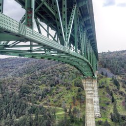
A site to behold: 730 feet tall from the North Fork American River to the deck. It is the tallest in California and 4th largest in the US. Besides driving across the bridge, you can walk across. Both sides of the freeway has a pedestrian sidewalk. The pedestrian barrier screen is over 6 1/2 feet tall. It is pretty neat walking across, but not for ones that are afraid of heights. Soak in the gorgeous south view of the beautiful canyon and confluence of the North Fork and American River. The times that I have walked across, there were other hikers and families with children and seniors. All were enjoying the views and the architecture of the bridge. Hiking Trail: At the ends of the bridge pedestrian sidewalk are hiking trails that you can take that meander on an incline down to the river. But remember it's harder hiking up than down, so don't bite off more than you can chew. Parking Situation: There are not official parking spots. You can just park in the dirt spots with a wide safe clearing. But the spots fill up on the weekend due to the popular hiking trails.

This place is still a gem and paradise for outdoor enthusiasts. No matter how many times I've come here the views never gets old. This time my views are form yeh bottom looking up as I head out on my mountain biking adventure. With the iconic bridge sitting high above the valley floor you can enjoy it the top or bottom, either way you can access numerous trails that will take you around the bridge and the local reservoir or the beautiful American River. If you're starting from the bottom you can hike toward Lake Clementine and view the bridge at different angles. This was taken in mid October and the weather was fantastic with many many people out enjoying the open space.

"Meanwhile, over in Auburn . . . " I've written this on Facebook many times when people talk about the drought and California's lack of water. So I remind them of the Auburn Dam, which would have taken care of much of the Big Tomato's water needs, it was approved by the State, and then the environmentalist wackos stepped in . . . So instead of a reservoir, we have a bridge that was meant to cross the lake, and ended up as one of the highest bridges in the world. It's nearly as high (730 feet) as the Golden Gate Bridge's towers are tall (746 feet). You get a stunning sense of the size of the bridge by both driving on it and walking under it. My wife and I have done both. When driving, you immediately see that you are up in the air very, very, very, very high. When walking, you're in a deep canyon on the American River, and the roadway is impossibly high above your head. Building this booger must have been an incredible engineering feat. Practically, it's sure faster driving to Foresthill with this bridge than with the winding road below it (still drivable). Want to have a nice picnic? Drive down 49 to the Confluence area of the Auburn Recreation Area, set out your lunch with a view of this bridge, and have a scenic picnic with both the beautiful foothills scenery and this massive bridge.

Found my new spot to train for all of the outdoor activities! I use to go out to Lake Natoma to run the trails and sands but it lacked distance variations in elevation. The terrain around Foresthill Bridge has all of that and more. I love coming out here and running the firebreak from the mail road up to the bridge, in order to train for the various terrains I've come to expect with Spartan Races. After running the Spartan Super in Monterrey last year, I knew Lake Natoma just wasn't going to cut it. And finally make it out to the Auburn Recreation Area a couple months later, which help with the half marathon Spartan Obstacle Course Race (ORC) in Lake Tahoe at Squaw Valley. There's an abundance of trails that vary in both distance and terrain. If you want a short muscle fatiguing, and lunges burning session; run the firebreak up to the bridge, across for half a mile or so, and then back down the winding trail on the other side. Or for a easy session take the road down to the side of the river and walk down through the old fort looking area, when you come across the closed off cave that on a warm day. Omits an eerily cold breeze as you pass the entrance along the trail over 100ft away. This particular trail I've taken out 4miles to complete an 11mi run/walk hiking session. If you want a varying level training sessions all at your fingertips, choose one of the many trails off in the hills that start off from one entrance. Some of the days I like short intense training for condition, or long medium paced sessions for distance. And in one area you can go from an eight mi. round trip walk, to a 28 mid climb. To the insane 97.3 mi. mile trek to Tahoe....yes they actually have a trail from Auburn that will take you to Lake Flippin' Tahoe! WTH? If the trails aren't necessarily your thing, the scenery around Foresthill Bridge is beautiful enough to just take in a short walk, or while you relax down by the water. I love coming out here, and would recommend it to anyone who loves the outdoors!

After years of hearing about this mighty bridge and considering that it's the tallest in California, the 4th tallest in the US, and 31st tallest in the world, I needed to check it out. Not only can you walk across the bridge and look down (probably not recommended for the acrophobic), but there are numerous hiking and mountain biking trails beneath. Plus, the river runs under it, so you can bring your bathing suit or lounge chair on a warm day and relax by the water. Most of the parking under the bridge area is self-service and $10. There are bathrooms near certain parking areas as well. I visited on a lovely, sunny, 75º day and brought my camera to capture a few shots. I had a great time walking the narrow dirt trails, hiking up hills, and traversing small streams. It's quite beautiful, especially in the spring when everything is green. I highly recommend taking a day trip here to enjoy a nice day outside and admire the engineering that went into building the great Foresthill Bridge. Don't forget your water. Trekking around makes you thirsty.

So I didn't do any hiking here, I just walked along the bridge and looked at the hand written notes tied to the tall railing. A lot of touching notes encouraging people not to commit suicide, which sadly means people have jumped off this bridge before. The rail is covered from end to end with these notes, mostly custom and hand written. There's an amazing view from the bridge, but it's a bit bitter sweet when you think about how many lives may have ended at this bridge. It's probably worth checking out if you've never been, and maybe the hiking is great, but this review is about the bridge itself, not the hiking, and I gotta say that if the anti-suicide notes weren't here, this bridge wouldn't even get noticed.

If you're in the Bay Area and are looking for a low-key weekend escape from reality (damn you Trump!), I suggest giving California's Gold Country a try. With hundreds of miles of diverse hiking trails and quaint little towns that are ripe with history, Gold Country is truly a sight to behold. But when you only have 24 hours here, where do you go? What do you do? Where do you eat? My girlfriend and I faced this exact "first-world" problem recently when we decided to make a spontaneous day-trip out to the wild California east. Even if you are only in this wondrous area for a fleeting moment, you have to check out the Auburn-Foresthill Bridge. We stopped by after lunch and o my goodness the experience was BREATHTAKING! Located 730 feet (!!!) above ground, the Foresthill Bridge is the tallest bridge in California. Coming into this structural masterpiece, we had already gotten a sense of how massive and picturesque the bridge was based off of pictures from the Interwebs. But dang, Foresthill was definitely one of those instances where you had to be in person to experience the magic in its entirety. It was awe-inspiring, domineering, and drop-dead beautiful. There are two ways to see the bridge: Above and below. To see it from the ground level, you can park along the North Fork American River and stare at the sheer size of the bridge while swimming gracefully in calm (for the most part) waters. From high up, you can actually drive all the way to the bridge itself. A lot of people cross the bridge frequently to get to and from Auburn/Foresthill. I definitely recommend this view because then you can appreciate how tall this beast is. From the bridge, everything below seemingly looked like ants. And from the top, you can actually walk ACROSS THE BRIDGE! It was a bit windy and scary for me, but you can do it if you're brave enough. But for the most daring of souls, I highly encourage y'all to take one of the many hiking trails in the area and actually ascend up to the bridge! The landscape is quite scenic, the paths are paved, and if you get lost just look up! When planning a trip out to Foresthill Bridge, just note that it's about 40 or so minutes from Sacramento (probably 3ish from the Bay Area). Getting there from the freeway is quite simple. If coming from Interstate 80, just exit Foresthill road and it'll be about five minutes until you see the bridge. For those taking Highway 49 (AKA Gold Country road), exit off Old Foresthill Road and then follow it until the bridge (about 20 minutes?). If you just want to take a snapshot of Foresthill from above, there's free parking right next to the bridge. I don't think there's actually a "time limit" but space can get tight. From below, I do believe you have to purchase a permit ($10?) as a lot of people come by just to swim in the river. I don't know why I do this to myself. I absolutely hate heights but I LOVE hiking peaks and checking out tall bridges. I think it's because the view is just so breathtaking that the opportunity can't be passed up. The same thing applied to Foresthill Bridge. You'll probably have to pay me life insurance before I walk across that thing, but gosh darnit I'll drive 2 hours to this place in order to get a view from the top. And for that reason I'll give this place an "Omg, I'd travel 2 hours for this" rating. Check it out. You won't regret it. Have fun and prosper,


OKAY....first let me say, we thought we would start at the upper lake and hike down to the dam, but uh....yeah....we didn't quite make it. This is rated as "easy" and the trail itself is, BUT the inclines can be vicious at times. The hike to Clark's pool is easy and a must! The water there is crystal clear...yeah, clear enough to see the sucker fish chilling on the rocks inside the lake. Once you get over that...take the plunge off of the rock! Moving on...about another .5 miles down , or should I say UP....i just had to ask how far we were from the dam and since the hiker cringed and told us another 1.5 miles UP- we decided to go back down and chill in the refreshing waters under the Foresthill Bridge!! This is a great place to just go and be without hiking! You pay at the ranger station, yes $10 for day use, and then go down under the bridge right there! There is a swimming hole, large rocks to perch on, great place to take kids and spend day! The bridge itself is massive and a great site to see! Don't miss it, and if you want to see the damn, park at the lower lake!

Highly recommend checking this wonder out....no pun ..hahaha it is a beautiful site to see and a bit of a thrill too. Please be very careful. I would not ever take young children. Parking is a bit nerve racking due to it's just turn outs on both sides. So not a true tourism local. Nor not for the faint of heart. But I loved it.

My girlfriends and I decided to check this bridge out since it was the the way home from our little girls trip in Truckee. The drive was an hour from Truckee to Foresthill Bridge. The site was amazing, and pretty interesting to know how tall the bridge was. I have a extreme fear of heights so I didnt go as far down to "check" the view. If you drive on the bridge there is parking to your left in which you must be careful slightly as there are cars that go down that road pretty fast. Once we parked we were able to walk, and there is a stairway that goes down, in which you can see under the bridge. There are a few trails and I different trails take you to a different view. Because I didnt go further, I was still able to capture a few photos and look at the height of this bridge. Overall if your on the way home and your passing by this area I would recommend to just check it out since you never know it might be gone 5, 10, 20 years down the line !

If you are ever in the area, be sure to check out one of the tallest bridges in the US. Sweeping views and amazing architecture. You can drive walk or bike across. Super close to the Clementine Dam lookout if you want another "instagram " photo op. read more


Great area for hiking and fantastic scenery. There's a lot of trails nearby of carrying intensities and I suggest looking these up prior to your visit. There's ample street parking but do note some require a $10 fee (bring cash). Masks don't seem to required on the trail, but still do your best to wear one! read more


5 years ago
Came here for a hike and an intimate view of this awe inspiring bridge. Found a loop hike that starts at the bottom of the valley where the North Fork American River winds around. It starts with a hard and steep climb. The Foresthill Bridge is California's highest bridge, which is some 730 feet above the bottom. The Golden Gate is only 220 feet from the water, so use that for reference. This stretch of the hike is difficult cuz you do have to climb that 700+ feet, and it is not gradual with gentle switchbacks. It is almost straight up for over 40 minutes. I found it even harder during the summer months in Auburn, where it can soar easily past the 80 degree mark, also with little shade. I had to break several times to rehydrate and get my breath back. This was harder than most climbs I attempt. The good is the length isn't that long. I've climbed many peaks some even double this length, but those were more gradual. This was fast and furious, done in less than an hour with lots of sweat. But when that initial climb is done, it is all views and a breeze from there on out. Once on top, you'll meet the highway that crosses the bridge. There is a pedestrian path, so you're nice and safe from zooming traffic. Now you can cross and look down if you dare, into the gorge. It is a thrilling look as now you'll feel the breeze and the glimpses only an eagle would experience. There will be a sad reminder though as you're crossing the bridge. Once you hit the middle of the bridge, you'll start to see handwritten cards taped to the bars of the bridge. It appears to be children or young teens, writing hand messages of encouragement, for people having a plan to commit suicide from those heights. It is sad yet inspiring to see those messages, very humanizing. Once you've crossed the bridge, it is all down hill back to the river. Again no shade but so much easier and faster than the way up. Like with most incline hikes I choose, I always choose to climb first and descend last. It's a solid work/reward progression. This is a gleaming example. Once back down to the river, I'd advise to explore a little down by the water. It was so hot the day I went, that I took off my shoes and waded in that ice cold water. It's a little tricky stepping onto the river stones so I didn't go too far out. Literally just enough to cool off, splashing that refreshing water onto my head and shoulders. It was so hot, that I dried up in no time, without a towel. Awesome end to a hard hike, with breathtaking views. No regrets here. read more


9 years ago
A site to behold: 730 feet tall from the North Fork American River to the deck. It is the tallest in California and 4th largest in the US. Besides driving across the bridge, you can walk across. Both sides of the freeway has a pedestrian sidewalk. The pedestrian barrier screen is over 6 1/2 feet tall. It is pretty neat walking across, but not for ones that are afraid of heights. Soak in the gorgeous south view of the beautiful canyon and confluence of the North Fork and American River. The times that I have walked across, there were other hikers and families with children and seniors. All were enjoying the views and the architecture of the bridge. Hiking Trail: At the ends of the bridge pedestrian sidewalk are hiking trails that you can take that meander on an incline down to the river. But remember it's harder hiking up than down, so don't bite off more than you can chew. Parking Situation: There are not official parking spots. You can just park in the dirt spots with a wide safe clearing. But the spots fill up on the weekend due to the popular hiking trails. read more


This place is still a gem and paradise for outdoor enthusiasts. No matter how many times I've come here the views never gets old. This time my views are form yeh bottom looking up as I head out on my mountain biking adventure. With the iconic bridge sitting high above the valley floor you can enjoy it the top or bottom, either way you can access numerous trails that will take you around the bridge and the local reservoir or the beautiful American River. If you're starting from the bottom you can hike toward Lake Clementine and view the bridge at different angles. This was taken in mid October and the weather was fantastic with many many people out enjoying the open space. read more


"Meanwhile, over in Auburn . . . " I've written this on Facebook many times when people talk about the drought and California's lack of water. So I remind them of the Auburn Dam, which would have taken care of much of the Big Tomato's water needs, it was approved by the State, and then the environmentalist wackos stepped in . . . So instead of a reservoir, we have a bridge that was meant to cross the lake, and ended up as one of the highest bridges in the world. It's nearly as high (730 feet) as the Golden Gate Bridge's towers are tall (746 feet). You get a stunning sense of the size of the bridge by both driving on it and walking under it. My wife and I have done both. When driving, you immediately see that you are up in the air very, very, very, very high. When walking, you're in a deep canyon on the American River, and the roadway is impossibly high above your head. Building this booger must have been an incredible engineering feat. Practically, it's sure faster driving to Foresthill with this bridge than with the winding road below it (still drivable). Want to have a nice picnic? Drive down 49 to the Confluence area of the Auburn Recreation Area, set out your lunch with a view of this bridge, and have a scenic picnic with both the beautiful foothills scenery and this massive bridge. read more

Found my new spot to train for all of the outdoor activities! I use to go out to Lake Natoma to run the trails and sands but it lacked distance variations in elevation. The terrain around Foresthill Bridge has all of that and more. I love coming out here and running the firebreak from the mail road up to the bridge, in order to train for the various terrains I've come to expect with Spartan Races. After running the Spartan Super in Monterrey last year, I knew Lake Natoma just wasn't going to cut it. And finally make it out to the Auburn Recreation Area a couple months later, which help with the half marathon Spartan Obstacle Course Race (ORC) in Lake Tahoe at Squaw Valley. There's an abundance of trails that vary in both distance and terrain. If you want a short muscle fatiguing, and lunges burning session; run the firebreak up to the bridge, across for half a mile or so, and then back down the winding trail on the other side. Or for a easy session take the road down to the side of the river and walk down through the old fort looking area, when you come across the closed off cave that on a warm day. Omits an eerily cold breeze as you pass the entrance along the trail over 100ft away. This particular trail I've taken out 4miles to complete an 11mi run/walk hiking session. If you want a varying level training sessions all at your fingertips, choose one of the many trails off in the hills that start off from one entrance. Some of the days I like short intense training for condition, or long medium paced sessions for distance. And in one area you can go from an eight mi. round trip walk, to a 28 mid climb. To the insane 97.3 mi. mile trek to Tahoe....yes they actually have a trail from Auburn that will take you to Lake Flippin' Tahoe! WTH? If the trails aren't necessarily your thing, the scenery around Foresthill Bridge is beautiful enough to just take in a short walk, or while you relax down by the water. I love coming out here, and would recommend it to anyone who loves the outdoors! read more


12 years ago
After years of hearing about this mighty bridge and considering that it's the tallest in California, the 4th tallest in the US, and 31st tallest in the world, I needed to check it out. Not only can you walk across the bridge and look down (probably not recommended for the acrophobic), but there are numerous hiking and mountain biking trails beneath. Plus, the river runs under it, so you can bring your bathing suit or lounge chair on a warm day and relax by the water. Most of the parking under the bridge area is self-service and $10. There are bathrooms near certain parking areas as well. I visited on a lovely, sunny, 75º day and brought my camera to capture a few shots. I had a great time walking the narrow dirt trails, hiking up hills, and traversing small streams. It's quite beautiful, especially in the spring when everything is green. I highly recommend taking a day trip here to enjoy a nice day outside and admire the engineering that went into building the great Foresthill Bridge. Don't forget your water. Trekking around makes you thirsty. read more

So I didn't do any hiking here, I just walked along the bridge and looked at the hand written notes tied to the tall railing. A lot of touching notes encouraging people not to commit suicide, which sadly means people have jumped off this bridge before. The rail is covered from end to end with these notes, mostly custom and hand written. There's an amazing view from the bridge, but it's a bit bitter sweet when you think about how many lives may have ended at this bridge. It's probably worth checking out if you've never been, and maybe the hiking is great, but this review is about the bridge itself, not the hiking, and I gotta say that if the anti-suicide notes weren't here, this bridge wouldn't even get noticed. read more


If you're in the Bay Area and are looking for a low-key weekend escape from reality (damn you Trump!), I suggest giving California's Gold Country a try. With hundreds of miles of diverse hiking trails and quaint little towns that are ripe with history, Gold Country is truly a sight to behold. But when you only have 24 hours here, where do you go? What do you do? Where do you eat? My girlfriend and I faced this exact "first-world" problem recently when we decided to make a spontaneous day-trip out to the wild California east. Even if you are only in this wondrous area for a fleeting moment, you have to check out the Auburn-Foresthill Bridge. We stopped by after lunch and o my goodness the experience was BREATHTAKING! Located 730 feet (!!!) above ground, the Foresthill Bridge is the tallest bridge in California. Coming into this structural masterpiece, we had already gotten a sense of how massive and picturesque the bridge was based off of pictures from the Interwebs. But dang, Foresthill was definitely one of those instances where you had to be in person to experience the magic in its entirety. It was awe-inspiring, domineering, and drop-dead beautiful. There are two ways to see the bridge: Above and below. To see it from the ground level, you can park along the North Fork American River and stare at the sheer size of the bridge while swimming gracefully in calm (for the most part) waters. From high up, you can actually drive all the way to the bridge itself. A lot of people cross the bridge frequently to get to and from Auburn/Foresthill. I definitely recommend this view because then you can appreciate how tall this beast is. From the bridge, everything below seemingly looked like ants. And from the top, you can actually walk ACROSS THE BRIDGE! It was a bit windy and scary for me, but you can do it if you're brave enough. But for the most daring of souls, I highly encourage y'all to take one of the many hiking trails in the area and actually ascend up to the bridge! The landscape is quite scenic, the paths are paved, and if you get lost just look up! When planning a trip out to Foresthill Bridge, just note that it's about 40 or so minutes from Sacramento (probably 3ish from the Bay Area). Getting there from the freeway is quite simple. If coming from Interstate 80, just exit Foresthill road and it'll be about five minutes until you see the bridge. For those taking Highway 49 (AKA Gold Country road), exit off Old Foresthill Road and then follow it until the bridge (about 20 minutes?). If you just want to take a snapshot of Foresthill from above, there's free parking right next to the bridge. I don't think there's actually a "time limit" but space can get tight. From below, I do believe you have to purchase a permit ($10?) as a lot of people come by just to swim in the river. I don't know why I do this to myself. I absolutely hate heights but I LOVE hiking peaks and checking out tall bridges. I think it's because the view is just so breathtaking that the opportunity can't be passed up. The same thing applied to Foresthill Bridge. You'll probably have to pay me life insurance before I walk across that thing, but gosh darnit I'll drive 2 hours to this place in order to get a view from the top. And for that reason I'll give this place an "Omg, I'd travel 2 hours for this" rating. Check it out. You won't regret it. Have fun and prosper, read more


7 years ago
If you like a Challange, you can hike up to the bridge, but it's a level 5 type a challange, or you can park by the bridge & hike down :). This bridge is a place to see if you are in the area. read more

OKAY....first let me say, we thought we would start at the upper lake and hike down to the dam, but uh....yeah....we didn't quite make it. This is rated as "easy" and the trail itself is, BUT the inclines can be vicious at times. The hike to Clark's pool is easy and a must! The water there is crystal clear...yeah, clear enough to see the sucker fish chilling on the rocks inside the lake. Once you get over that...take the plunge off of the rock! Moving on...about another .5 miles down , or should I say UP....i just had to ask how far we were from the dam and since the hiker cringed and told us another 1.5 miles UP- we decided to go back down and chill in the refreshing waters under the Foresthill Bridge!! This is a great place to just go and be without hiking! You pay at the ranger station, yes $10 for day use, and then go down under the bridge right there! There is a swimming hole, large rocks to perch on, great place to take kids and spend day! The bridge itself is massive and a great site to see! Don't miss it, and if you want to see the damn, park at the lower lake! read more


Highly recommend checking this wonder out....no pun ..hahaha it is a beautiful site to see and a bit of a thrill too. Please be very careful. I would not ever take young children. Parking is a bit nerve racking due to it's just turn outs on both sides. So not a true tourism local. Nor not for the faint of heart. But I loved it. read more

10 years ago
My girlfriends and I decided to check this bridge out since it was the the way home from our little girls trip in Truckee. The drive was an hour from Truckee to Foresthill Bridge. The site was amazing, and pretty interesting to know how tall the bridge was. I have a extreme fear of heights so I didnt go as far down to "check" the view. If you drive on the bridge there is parking to your left in which you must be careful slightly as there are cars that go down that road pretty fast. Once we parked we were able to walk, and there is a stairway that goes down, in which you can see under the bridge. There are a few trails and I different trails take you to a different view. Because I didnt go further, I was still able to capture a few photos and look at the height of this bridge. Overall if your on the way home and your passing by this area I would recommend to just check it out since you never know it might be gone 5, 10, 20 years down the line ! read more


8 years ago
Hike down was fairly easy, there are multiple trails you can take and it's a great escape from the city. We eventually hiked up to a spot where it was quiet, secluded, and peaceful. I would highly suggest making the trip!!! read more


9 years ago
8 years ago
9 years ago
10 years ago
Take the steep route and stay to the left. Go towards pig farm trail. You'll run into a little surprise waterfall. It's a pretty tough hike but it's so worth it. read more


10 years ago
A nice little drive from Sacramento up winding roads to get to the bridge. Don't go if you're afraid of heights. You can park the car and walk across the bridge, or you can access a hiking trail from up here. Either way it makes for a great day out! If you like you can also drive down and enjoy the view up from below the bridge. read more


11 years ago
13 years ago
We spent the day in Auburn and heard about the bridge. We were told it was one of the 5 highest bridges in the U.S. and decided to drive 4 miles up the road to check it out. There was an obvious parking area on the far end of the bridge. We parked and then walk across the bridge on the designated walking path. I'm so glad we decided to go. I must admit it was a bit challenging to walk across if you have a thing for heights but worth it for the beautiful view of a river about 700 feet below. read more

11 years ago
More info about Foresthill Bridge
Ask the Community - Foresthill Bridge
Review Highlights - Foresthill Bridge


Foresthill Bridge - landmarks - Updated June 2026
Best of Auburn
People found Foresthill Bridge by searching for…
Swimming Holes in Auburn, California
Hiking Trails With Waterfalls in Auburn, California
Things to Do in Auburn, California
Places to Take Pictures in Auburn, California
River Swimming in Auburn, California
Scenic View in Auburn, California
Scenic Drive in Auburn, California
Fishing Spots in Auburn, California
Secret Spots in Auburn, California
Fun Things to Do With Kids in Auburn, California
Beautiful Views in Auburn, California
Picnic Areas in Auburn, California
Walking Trails in Auburn, California
View Points in Auburn, California
Tourist Attractions in Auburn, California
Photo Spots in Auburn, California
Free Parking in Auburn, California
Day Trips in Auburn, California
Public Services & Government in Auburn, California
Restaurants With a View in Auburn, California
Trending Searches in Auburn, CA
Black Owned Nail Salons near Foresthill Bridge
Boardwalk near Foresthill Bridge
Boat Rental near Foresthill Bridge
Cliff Jumping near Foresthill Bridge
Day Trips near Foresthill Bridge
Fireworks near Foresthill Bridge
Fishing Spots near Foresthill Bridge
Flower Fields near Foresthill Bridge
Hidden Gems near Foresthill Bridge
Historical Sites near Foresthill Bridge
Jet Ski Rental near Foresthill Bridge
Kayak Rental near Foresthill Bridge
Landmarks & Historical Buildings near Foresthill Bridge
Picnic Areas near Foresthill Bridge
Places To Visit near Foresthill Bridge
Places To Walk Around near Foresthill Bridge
Public Pools near Foresthill Bridge
River Swimming near Foresthill Bridge
Scenic Restaurants near Foresthill Bridge
Secluded Spots near Foresthill Bridge
Soccer Store near Foresthill Bridge
Splash Pad near Foresthill Bridge
Strawberry Picking near Foresthill Bridge
Swimming Holes near Foresthill Bridge
Swimming Lakes near Foresthill Bridge
Things To Do This Weekend near Foresthill Bridge
Things To See near Foresthill Bridge
Browse Articles
Browse Nearby
BEST of Auburn, California Restaurants near Foresthill Bridge
BEST of Auburn, California Coffee near Foresthill Bridge
BEST of Auburn, California Things to Do near Foresthill Bridge
BEST of Auburn, California Breakfast near Foresthill Bridge
BEST of Auburn, California Museums near Foresthill Bridge
BEST of Auburn, California Parks near Foresthill Bridge
BEST of Auburn, California Hotels near Foresthill Bridge
BEST of Auburn, California Gold Panning near Foresthill Bridge
BEST of Auburn, California Campgrounds near Foresthill Bridge
Browse Brands
Related Searches in Auburn, CA
Best Fun Things to Do in Auburn, California
Best Lookout Points to Visit in Auburn, California
Best Nature Trails for Hiking in Auburn, California
Book Engaging Historical Tours in Auburn, California
Discover Famous Monuments in Auburn, California
Discover Popular Photo Spots in Auburn, California
Discover Stunning Skyline View Spots in Auburn, California
Discover Top Nature Parks to Visit in Auburn, California
Discover Top Scenic Spots to Visit in Auburn, California
Enjoy Scenic Night View Experiences in Auburn, California
Enjoy the Best Walking Trails in Auburn, California
Explore Beautiful Botanical Gardens in Auburn, California
Explore Beautiful Parks and Green Spaces in Auburn, California
Explore Children's Museums Near Auburn, California
Explore Easy Hikes Perfect for All in Auburn, California
Explore Free Things to Do Around Auburn, California
Explore Fun Activities to Do in Auburn, California
Explore Fun Field Trips in Auburn, California
Explore Popular Scenic Overlook Points in Auburn, California
Explore Popular Scenic Views Near Auburn, California
Explore Popular View Points Around Auburn, California
Explore Top Art Galleries Located in Auburn, California
Explore Top Haunted Places Near Auburn, California
Explore Venues & Event Spaces in Auburn, California
Explore the Best Trail Options in Auburn, California
Find Beautiful Views in Auburn, California
Find Fun Things to Do With Kids in Auburn, California
Find Top Art Museums in Auburn, California
Find Top Libraries to Visit in Auburn, California
Find Top-Rated Waterfalls in Auburn, California Now
Find a Public Library Near You in Auburn, California
Find the Best Bridge Spots in Auburn, California
Find the Best Playgrounds to Visit in Auburn, California
Hiking Trails With Waterfalls in Auburn, California
Must-See Tourist Attractions Around Auburn, California
Popular Outdoor Activities to Try in Auburn, California
Popular Picnic Spots to Visit in Auburn, California
Popular Places to Take Pictures in Auburn, California
Popular Places to Walk Around in Auburn, California
Popular Things to Do in Auburn, California
Popular Things to See in Auburn, California
Top Hiking Trails to Explore in Auburn, California
Top Historic Restaurants to Try in Auburn, California
Top Museums for Kids to Visit in Auburn, California
Top Things to Do With Kids in Auburn, California
Tour Popular Historical Sites in Auburn, California
Visit Beautiful Gardens in Auburn, California
Visit Popular Museums in Auburn, California Now