Ponderosa Way Bridge Photos


More like Ponderosa Way Bridge
Recommended Reviews - Ponderosa Way Bridge
Start your review...

Reviews With Photos

I love swimming and sunning. I am obsessed with finding swimming holes in my area and this is a good one! Living in NorCal, there are numerous swimming holes to choose from, and this is one! The only drawback is that you are driving five miles in a one lane dirt road. I wouldn't suggest you drive here in anything other than a 4WD, but people do it, and I don't recommend it. Although the five miles can be long especially on a windy, bumpy road...this swimming hole is well worth the drive! It's perfect! Not as crowded as some of your other swimming holes and clean port a potties! People are really respectful and not much riff-raff. I say this because one of our favorite swimming holes has become quite popular and in my recent trips, we noticed so much trash and people disrespecting the rules. People!! Pick up after yourselves! This place isn't as crowded and we didn't see any broken glass or trash being left behind. The water is just as inviting as our favorite hole and the water is just as refreshing. The water was calm and there's a lot of sandy beach areas. I'll come back again next year!

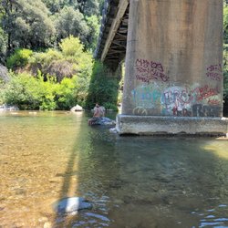
Awesome bridge at the bottom of Ponderosa Way from Weimar. You have to go down a very rocky, narrow non paved road to get to the bridge. I did it on my cross bike and it was a harrowing descent down to the bottom. Many rocks and washed out road sections to get to the bottom. When you get there, you are rewarded with this gorgeous bridge. Take a picture as then it's a long ride back up to the top!

I absolutely love coming to this place. Ever since I found out about this place a few months ago, I just can't stop coming here. First of all when you try to get to this place, Google Maps will lead you to a place where the road kind of ends. And when I mean that the road will and I'm talking about the paved Road will end. This is not mean that you stop driving, you have to start driving onto the unpaved portion of the trail which will lead you all the way down to the bridge. I must warn everyone that when they come here, please be prepared to drive on some really bumpy Terrain. I drive a crossover vehicle and even with my vehicle I kind of had to take it just a little bit slow so that way I don't damage my undercarriage on my vehicle. Surprisingly, I see some regular Passenger cars that drive onto this road. It makes me wonder how the heck do these vehicles even make it out onto this road! Also, this road is a shared road so I highly advise everyone to be aware of what's in front of them and to share the road with everyone who uses it. Once you get down to the very end of the road you will reach the bridge. This is where you can park your vehicle, keep in mind that there is absolutely no parking on the side of the road except for when you reach the bridge because as I said earlier the road is very narrow and it is shared with oncoming traffic. Once you reach the bridge, you will find that there is a pay station although at this time I think that it is not applicable because there are no more envelopes in there. Also, there are two porta-potties and there is a lockable trash can for dumping your trash into there. The bridge itself can support vehicles including large vans. I just saw one van drive across it today. I do not know where the other side of the road goes but I believe it's farther inland. There is a painted sign on the bridge says no diving off of the bridge. This is probably due to the fact that the floor of the river is quite shallow from the surface or the river so if you want to dive off of it you can potentially hit your head. Quite often you can see River rafts and kayaks come through this River. There's also a Trail off to the side which you can hyconn and it will take you about 30 to 45 minutes if you are walking to reach the waterfall area. There was also some turn offs from the main path which can lead you to the River Bar and there is another turn off which is very technical but if you can do it you can scale up the side of a mountain to get to a secret spot to take selfies at but keep in mind you are on your own and if you hurt yourself that is just too bad. I get this place of Solid 5 stars! If you like to come and get away from the noisy City and get some peace in mind being out in nature than this is the place to hit up.

I'm glad we came in a SUV, because it was a bumpy ride. I wouldn't want to drive there myself on the narrow and steep road. I'm nervous when it comes to driving on bridges as well. There's parking right before the bridge, so we went over it and back for nothing. A sign stated there's a $10 entrance fee but there was nobody collecting money. The Codfish Creek Falls Discovery Trail is easy to navigate for a beginner hiker. It's 2.4 miles roundtrip. The American River was to the left of us as we hiked up. The trail is narrow with lots of trees providing shade. There was a porta-potty along the way, but I would never think of using it. The trail leads you to a waterfall at the end. The waterfall was weak though, since we went in January and there hasn't been much rainfall. Luckily, none of us saw any poison oak.

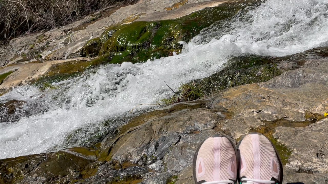
This is a year round GEM! Up until last weekend, my experience with this place had been going out here almost every weekend in the summer (when I wasn't knocked up that is). Amazing swimming location with rocks to jump off of, an "island" in the middle of the river to set up your easy up and chairs, and a nice slow flow to the river so little ones are ok to swim. (But no lifeguard available, so just keep that in mind if you do let your kids swim). By far my favorite river locale in Sacramento to hang out at. I had always seen the beginning of the hiking trail, but until last weekend had never tried it. It is a mostly flat, 1.7 mile (each way) hike to a waterfall that was RAGING when we visited last weekend after all of our recent rain! The kids had a blast - my two preschoolers did it in about 3 hours, including the time spent hanging out at the waterfall. Our littlest hikers - 2 and 9 months - conked out about halfway through, so if your babies are small bring a good child carrier backpack! There are porta potties at the head of the trail, as is the ranger "station" in the summer time. Parking is $10 per day, although when we went last weekend the box for dropping day fees was gone. In the summer however, the rangers are out all day, especially on the weekends.

Went to the wrong ponderosa way bridge, please be careful of your directions as these pictures interpreted a bridge in Weimar by google maps gave us a bridge in the middle of absolutely nowhere. Please don't drive a regular car down this road. My 94' Toyota Corolla sounded like it was being ripped apart every time we hit a bump or ran over the bushes in the middle of the path. Had 2 mental breakdowns on the way down and back up, make sure you go to the right one!!!!

9 months ago
Less then a 5 min walk down to one of northern Californias best swimming holes! Pet friendly, but bring your own shade as there isnt much during the peak of the day. read more


2 years ago
This is a world-class hike! It has all of the things to make a hike fun, adventurous, and magical. First of all, it's kind of out-of-the-way so that makes it extra interesting, exciting, and enjoyable. There' were tons of wildflowers right along the river, and by the trail. The hike to Codfish Falls is leveled. It's such a pleasant and easy day hike, even with young kids. There's a gorgeous meadow with a nearby river where you can have a picnic or take a nap. There's an amazing payoff at the end of the hike, the beautiful Codfish Waterfalls. There were only 10 to 13 parking spots which are free. A big RV or trucks will take more spaces. Watch out for poison oaks. There are many along the hiking trail. Highly recommended it to you all. read more


9 months ago
I love swimming and sunning. I am obsessed with finding swimming holes in my area and this is a good one! Living in NorCal, there are numerous swimming holes to choose from, and this is one! The only drawback is that you are driving five miles in a one lane dirt road. I wouldn't suggest you drive here in anything other than a 4WD, but people do it, and I don't recommend it. Although the five miles can be long especially on a windy, bumpy road...this swimming hole is well worth the drive! It's perfect! Not as crowded as some of your other swimming holes and clean port a potties! People are really respectful and not much riff-raff. I say this because one of our favorite swimming holes has become quite popular and in my recent trips, we noticed so much trash and people disrespecting the rules. People!! Pick up after yourselves! This place isn't as crowded and we didn't see any broken glass or trash being left behind. The water is just as inviting as our favorite hole and the water is just as refreshing. The water was calm and there's a lot of sandy beach areas. I'll come back again next year! read more


2 years ago
Awesome bridge at the bottom of Ponderosa Way from Weimar. You have to go down a very rocky, narrow non paved road to get to the bridge. I did it on my cross bike and it was a harrowing descent down to the bottom. Many rocks and washed out road sections to get to the bottom. When you get there, you are rewarded with this gorgeous bridge. Take a picture as then it's a long ride back up to the top! read more


8 years ago
I absolutely love coming to this place. Ever since I found out about this place a few months ago, I just can't stop coming here. First of all when you try to get to this place, Google Maps will lead you to a place where the road kind of ends. And when I mean that the road will and I'm talking about the paved Road will end. This is not mean that you stop driving, you have to start driving onto the unpaved portion of the trail which will lead you all the way down to the bridge. I must warn everyone that when they come here, please be prepared to drive on some really bumpy Terrain. I drive a crossover vehicle and even with my vehicle I kind of had to take it just a little bit slow so that way I don't damage my undercarriage on my vehicle. Surprisingly, I see some regular Passenger cars that drive onto this road. It makes me wonder how the heck do these vehicles even make it out onto this road! Also, this road is a shared road so I highly advise everyone to be aware of what's in front of them and to share the road with everyone who uses it. Once you get down to the very end of the road you will reach the bridge. This is where you can park your vehicle, keep in mind that there is absolutely no parking on the side of the road except for when you reach the bridge because as I said earlier the road is very narrow and it is shared with oncoming traffic. Once you reach the bridge, you will find that there is a pay station although at this time I think that it is not applicable because there are no more envelopes in there. Also, there are two porta-potties and there is a lockable trash can for dumping your trash into there. The bridge itself can support vehicles including large vans. I just saw one van drive across it today. I do not know where the other side of the road goes but I believe it's farther inland. There is a painted sign on the bridge says no diving off of the bridge. This is probably due to the fact that the floor of the river is quite shallow from the surface or the river so if you want to dive off of it you can potentially hit your head. Quite often you can see River rafts and kayaks come through this River. There's also a Trail off to the side which you can hyconn and it will take you about 30 to 45 minutes if you are walking to reach the waterfall area. There was also some turn offs from the main path which can lead you to the River Bar and there is another turn off which is very technical but if you can do it you can scale up the side of a mountain to get to a secret spot to take selfies at but keep in mind you are on your own and if you hurt yourself that is just too bad. I get this place of Solid 5 stars! If you like to come and get away from the noisy City and get some peace in mind being out in nature than this is the place to hit up. read more

I'm glad we came in a SUV, because it was a bumpy ride. I wouldn't want to drive there myself on the narrow and steep road. I'm nervous when it comes to driving on bridges as well. There's parking right before the bridge, so we went over it and back for nothing. A sign stated there's a $10 entrance fee but there was nobody collecting money. The Codfish Creek Falls Discovery Trail is easy to navigate for a beginner hiker. It's 2.4 miles roundtrip. The American River was to the left of us as we hiked up. The trail is narrow with lots of trees providing shade. There was a porta-potty along the way, but I would never think of using it. The trail leads you to a waterfall at the end. The waterfall was weak though, since we went in January and there hasn't been much rainfall. Luckily, none of us saw any poison oak. read more


This is a year round GEM! Up until last weekend, my experience with this place had been going out here almost every weekend in the summer (when I wasn't knocked up that is). Amazing swimming location with rocks to jump off of, an "island" in the middle of the river to set up your easy up and chairs, and a nice slow flow to the river so little ones are ok to swim. (But no lifeguard available, so just keep that in mind if you do let your kids swim). By far my favorite river locale in Sacramento to hang out at. I had always seen the beginning of the hiking trail, but until last weekend had never tried it. It is a mostly flat, 1.7 mile (each way) hike to a waterfall that was RAGING when we visited last weekend after all of our recent rain! The kids had a blast - my two preschoolers did it in about 3 hours, including the time spent hanging out at the waterfall. Our littlest hikers - 2 and 9 months - conked out about halfway through, so if your babies are small bring a good child carrier backpack! There are porta potties at the head of the trail, as is the ranger "station" in the summer time. Parking is $10 per day, although when we went last weekend the box for dropping day fees was gone. In the summer however, the rangers are out all day, especially on the weekends. read more


7 years ago
7 years ago
Went to the wrong ponderosa way bridge, please be careful of your directions as these pictures interpreted a bridge in Weimar by google maps gave us a bridge in the middle of absolutely nowhere. Please don't drive a regular car down this road. My 94' Toyota Corolla sounded like it was being ripped apart every time we hit a bump or ran over the bushes in the middle of the path. Had 2 mental breakdowns on the way down and back up, make sure you go to the right one!!!! read more


8 years ago
8 years ago
9 years ago
7 years ago
10 years ago
14 years ago
15 years ago
I came here on 7-3-11. Effective this year the state is stationing rangers to collect a $10 entrance fee at the beginning of Ponderosa Way. This wasn't noted anywhere so we had to drive back about 10 minutes to a little store that let us get cash - he said we were their third one that day and that this was the first year the state was charging at this access point. The drive down Ponderosa Way was pretty bumpy and steep at a few places, but my wimp meter is pretty pathetic so it probably wouldn't bother anyone else. :) Please take caution as there are many idiots that drive this road much faster than they should - pay attention especially around blind corners. If 2 vehicles are passing on the road at once it can be a tight squeeze. Common courtesy helps here. There were many regular cars (camrys, corollas, accords, etc) that made it down this road okay but a truck would be your best bet. Parking is just before the Ponderosa Bridge, lots of photo ops along the way. There is a small box near the beginning of the Codfish Creek Falls Trail with maps of the trail and the area - you can print these offline ahead of time if you think you need one but this trail is very clearly marked. The trail parallels the North Fork of the American River for probably the first mile or so - which was flowing fast and pretty cold. There are several places to get off the trail and hang out by the river. We went straight to the falls - super pretty 40-50ft. falls! You can hike up to almost halfway up the falls - go around the rocks on the right - it isn't as slippery as the left side. There is also a steep trail about a minute before the falls where you can hike up and actually get to the top of the falls for a pretty awesome view. You can also hike down past the bottom of the falls for some really pretty little pools where your kids or dogs can hang out and play in the water. There were TONS of butterflies and frogs right by the falls. There were a lot of people floating down the river in tubes and a bunch of people hanging out near the bridge when we returned from the hike. Seems like a pretty neat place to hang out. We passed several commercial rafting trip vans on the way back up Ponderosa Way, I'd imagine they were picking up rafters but haven't looked into it yet. Also worth mentioning is the few portable restrooms located along the trails for those that need it. Poison oak was plentiful along the side of the trail. Easy, well maintained hike. Take water and sunscreen. read more


15 years ago
11 years ago
More info about Ponderosa Way Bridge
Ask the Community - Ponderosa Way Bridge
Review Highlights - Ponderosa Way Bridge


Why does Yelp recommend reviews?
3 reviews that are not currently recommended
The reviews below are not factored into the business's overall star rating.
7 years ago
10 years ago
4 years ago
Ponderosa Way Bridge - landmarks - Updated May 2026
Best of Colfax
People found Ponderosa Way Bridge by searching for…
Trending Searches in Colfax, CA
Boardwalk near Ponderosa Way Bridge
Botanical Gardens near Ponderosa Way Bridge
Bounce House Rentals near Ponderosa Way Bridge
Campgrounds near Ponderosa Way Bridge
Castles near Ponderosa Way Bridge
Cheap Plants near Ponderosa Way Bridge
Cherry Picking near Ponderosa Way Bridge
Cliff Jumping near Ponderosa Way Bridge
Flower Shop near Ponderosa Way Bridge
Garage Sales near Ponderosa Way Bridge
Garden Center near Ponderosa Way Bridge
Gold Panning near Ponderosa Way Bridge
Hidden Gems near Ponderosa Way Bridge
Historic Homes near Ponderosa Way Bridge
Landmarks & Historical Buildings near Ponderosa Way Bridge
Nurseries & Gardening near Ponderosa Way Bridge
Outdoor Furniture Stores near Ponderosa Way Bridge
Party Equipment Rentals near Ponderosa Way Bridge
Pedicure near Ponderosa Way Bridge
Photo Spots near Ponderosa Way Bridge
Places To Take Pictures near Ponderosa Way Bridge
Places To Walk Around near Ponderosa Way Bridge
Public Art near Ponderosa Way Bridge
Rv Rental near Ponderosa Way Bridge
Spray Tanning near Ponderosa Way Bridge
Sunset View near Ponderosa Way Bridge
Table And Chair Rentals near Ponderosa Way Bridge
Things To Do Alone near Ponderosa Way Bridge
Browse Articles
Browse Nearby
BEST of Colfax, California Restaurants near Ponderosa Way Bridge
BEST of Colfax, California Coffee near Ponderosa Way Bridge
BEST of Colfax, California Things to Do near Ponderosa Way Bridge
BEST of Colfax, California Breakfast near Ponderosa Way Bridge
BEST of Colfax, California Wineries near Ponderosa Way Bridge
BEST of Colfax, California Thrift Stores near Ponderosa Way Bridge
Browse Brands
Related Searches in Colfax, CA
Best Fun Things to Do in Colfax, California
Best Lookout Points to Visit in Colfax, California
Best Nature Trails for Hiking in Colfax, California
Book Engaging Historical Tours in Colfax, California
Discover Charming Historic Homes in Colfax, California
Discover Famous Monuments in Colfax, California
Discover Popular Landmarks in Colfax, California
Discover Popular Photo Spots in Colfax, California
Discover Top Nature Parks to Visit in Colfax, California
Enjoy Scenic Night View Experiences in Colfax, California
Enjoy the Best Walking Trails in Colfax, California
Explore Beautiful Botanical Gardens in Colfax, California
Explore Beautiful Castles and Landmarks in Colfax, California
Explore Beautiful Parks and Green Spaces in Colfax, California
Explore Children's Museums Near Colfax, California
Explore Easy Hikes Perfect for All in Colfax, California
Explore Free Things to Do Around Colfax, California
Explore Fun Activities to Do in Colfax, California
Explore Fun Field Trips in Colfax, California
Explore Popular Scenic Views Near Colfax, California
Explore Popular View Points Around Colfax, California
Explore Secret Spots Worth Visiting in Colfax, California
Explore Top Art Galleries Located in Colfax, California
Explore Top Haunted Places Near Colfax, California
Explore Venues & Event Spaces in Colfax, California
Explore the Best Trail Options in Colfax, California
Find Beautiful Views in Colfax, California
Find Top Art Museums in Colfax, California
Find Top Libraries to Visit in Colfax, California
Find Top-Rated Waterfalls in Colfax, California Now
Find a Public Library Near You in Colfax, California
Find the Best Playgrounds to Visit in Colfax, California
Must-See Tourist Attractions Around Colfax, California
Popular Picnic Spots to Visit in Colfax, California
Popular Places to Go in Colfax, California
Popular Places to Take Pictures in Colfax, California
Popular Places to Walk Around in Colfax, California
Popular Things to Do in Colfax, California
Popular Things to See in Colfax, California
Top Hiking Trails to Explore in Colfax, California
Top Historic Restaurants to Try in Colfax, California
Top Museums for Kids to Visit in Colfax, California
Top Places to Visit in Colfax, California for Sightseeing
Top Things to Do With Kids in Colfax, California
Tour Famous Lighthouses Located in Colfax, California
Tour Popular Historical Sites in Colfax, California
Visit Beautiful Gardens in Colfax, California
Visit Popular Museums in Colfax, California Now