China Wall Photos


More like China Wall
Recommended Reviews - China Wall
Start your review...

Reviews With Photos

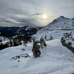
On the recommendation of Nelson, the Railroad Museum Docent, we took the chance on finding and exploring China Wall. Best local recommendation ever given! Google it and you'll get pretty exact directions on how to get here. Before you reach the China Wall you will pass actual petroglyphs. Apparently they are something like 6,000 years old. They are so awesome and right there for you to see. We stood there and tried to imagine what these ancient peoples were trying to express on these stones. Its amazing! Then hike up to the China Wall. These tunnels are defunct railway tunnels. Some of the first to cross California. Its not a bad hike. From the point we hiked up I would recommend going to the left. Some of the tunnels are the actual mountain rock that has been blown out to form the tunnel. This was one of the most fantastic adventures I've been on. The graffiti is one of the highlights of going down the dark tunnels. You wont believe what you're looking at. In the mid morning light we didn't need a flash light but you should bring one just in case. We walked aways down the tunnel that went into the mountain then walked back out to the side that is the big concrete box tunnels. You can walk on the top of them to see the views. The size of the these tunnels cannot be described. They are massive man made structures that are just laying here dormant. You have to come check this out. Take your time and explore. This is something you cannot miss when in Truckee.


9 months ago
Great hike, the tunnels were so cool. I think the part people "miss" is they are walking over what is considered China Wall. If you are walking the tunnels you can't see this engineering feat from the trail. You need a side quest or to start from a lower vantage point to see the actual wall. read more


This place is super unique!!! No idea why they don't advertise this place more. There's a parking lot on your left shortly before you hit the rainbow bridge. If the weather is nice, you'll see a bunch of climbers right here. From the lot, proceed uphill for a short distance and you'll see the petroglyphs on the rocks to your left. Proceed up these and you'll hit the tunnels! Go to the left for the best ones. I'd recommend going with someone as it can be a bit creepy in the darker areas and you never know what can happen. A flashlight or headlamp is a good idea but you're phone will suffice. There are openings every now and then so it's not like a cave or pitch dark. Tons of graffiti everywhere in a tunnel view which make for some awesome photos (reason 2 to have a partner or IG BF on hand). Enjoy!! read more


Summer and school breaks are our favorite times for family adventures. Once school starts, life gets hectic! This year we have a foreign exchange student with us, so we've added to that hectic-ness by a lot. Haha! One up side is the "extra credit" work in US History. The history teacher assigned a trip to China Wall with specific graffiti look-fors to find and take a picture with. We decided to pack up the family and had an AMAZING adventure!!! Our party was 7 people ages 2-35, and everyone had a great time! The 2 year old made it there climbing and hiking (he LOVES to climb), but he was donzo on the way back. We parked around 5:30 and started our way back to the car around 7:30. We visited three tunnels, but didn't get to the end of the one to the left. Lots of places to take a detour. So fun! Take 80 and exit Donner Lake Road toward Donner Lake. Continue west past the lake and gaining in elevation. Park on the left just before Donner Summit Bridge (we were able to turn around when we saw the bridge - whoops!). Either go down then up toward the wall from the parking area or walk west along the road until you see the much flatter rocks and take those toward the wall. HAVE FUN! read more


On the recommendation of Nelson, the Railroad Museum Docent, we took the chance on finding and exploring China Wall. Best local recommendation ever given! Google it and you'll get pretty exact directions on how to get here. Before you reach the China Wall you will pass actual petroglyphs. Apparently they are something like 6,000 years old. They are so awesome and right there for you to see. We stood there and tried to imagine what these ancient peoples were trying to express on these stones. Its amazing! Then hike up to the China Wall. These tunnels are defunct railway tunnels. Some of the first to cross California. Its not a bad hike. From the point we hiked up I would recommend going to the left. Some of the tunnels are the actual mountain rock that has been blown out to form the tunnel. This was one of the most fantastic adventures I've been on. The graffiti is one of the highlights of going down the dark tunnels. You wont believe what you're looking at. In the mid morning light we didn't need a flash light but you should bring one just in case. We walked aways down the tunnel that went into the mountain then walked back out to the side that is the big concrete box tunnels. You can walk on the top of them to see the views. The size of the these tunnels cannot be described. They are massive man made structures that are just laying here dormant. You have to come check this out. Take your time and explore. This is something you cannot miss when in Truckee. read more


6 years ago
Great spot on the other side of the Donner tunnel although you'll have to make it through the historic tunnel (which is a 20 minute walk) read more


7 years ago
Why this isn't on every Tahoe and Truckee visitors guides I have no idea. One of the coolest, creepiest, yet amazing places I've seen in this area. Pictures do it no justice. My wife was going for me, and wasn't interested, yet she thoroughly enjoyed it and said she is so happy she did not miss it. I did some reading about it, and found that these tracks were active until 1993 with the railroad made a new tunnel about a mile south through the Judah mountain. They quickly removed all the railroad tracks and reusable items leaving the snow sheds and tunnels abandoned. I recommend doing some internet searches afterwards because there's some great articles out there. This one has a great description of the history and have some great tips on what to bring, and how to dress depending on the time of year. http://www.calexplornia.com/donner-summit-train-tunnels-historical-journey-abandoned-train-tunnels/ Hike was not that hard if you go up through the petroglyphs. Kids should be able to make it no problem, however it's definitely not wheelchair or stroller-friendly. I would say the hike up to the China wall is moderate. If you were in the Tahoe Truckee area you do not want to miss this! Probably the creepiest thing was when my wife and I were deep in tunnel eight and it's the longest, we both heard a train horn. ( Yes probably someone playing it on their phone, or maybe you can hear from the new tracks/ tunnel) but that was freaky. It's not scary, but eerie, creepy and amazing all at once. read more


5 years ago
8 years ago
8 years ago
6 years ago
More info about China Wall
Ask the Community - China Wall
Review Highlights - China Wall


China Wall - landmarks - Updated June 2026
Best of Truckee
People found China Wall by searching for…
Things to Do in Truckee, California
Museums in Truckee, California
Photo Spots in Truckee, California
Hiking Trails With Waterfalls in Truckee, California
Places to Take Pictures in Truckee, California
Graffiti Wall in Truckee, California
Waterfalls and Swimming Holes in Truckee, California
Scenic View in Truckee, California
Historical Sites in Truckee, California
Scenic Drive in Truckee, California
View Points in Truckee, California
Waterfalls in Truckee, California
Things to Do on a Rainy Day in Truckee, California
Points of Interest in Truckee, California
Scenic Overlook in Truckee, California
Old Town in Truckee, California
Things to See in Truckee, California
Abandoned Buildings in Truckee, California
Trending Searches in Truckee, CA
Black Owned Nail Salons near China Wall
Historical Sites near China Wall
Jet Ski Rental near China Wall
Landmarks & Historical Buildings near China Wall
Places To Visit near China Wall
River Swimming near China Wall
Scenic Restaurants near China Wall
Secluded Spots near China Wall
Strawberry Picking near China Wall
Swimming Holes near China Wall
Swimming Lakes near China Wall
Browse Articles
Browse Nearby
BEST of Truckee, California Coffee near China Wall
BEST of Truckee, California Restaurants near China Wall
BEST of Truckee, California Things to Do near China Wall
BEST of Truckee, California Breakfast near China Wall
BEST of Truckee, California Museums near China Wall
BEST of Truckee, California Hiking near China Wall
BEST of Truckee, California Hotels near China Wall
Browse Brands
Related Searches in Truckee, CA
Best Lookout Points to Visit in Truckee, California
Book Engaging Historical Tours in Truckee, California
Discover Charming Historic Homes in Truckee, California
Discover Famous Monuments in Truckee, California
Discover Popular Landmarks in Truckee, California
Discover Popular Photo Spots in Truckee, California
Discover Stunning Skyline View Spots in Truckee, California
Discover Top Points of Interest in Truckee, California
Discover the Best Interactive Museum in Truckee, California
Discover the Best Planetarium Shows in Truckee, California
Enjoy the Best Walking Trails in Truckee, California
Experience Stunning Sunset Views in Truckee, California
Explore Beautiful Botanical Gardens in Truckee, California
Explore Beautiful Castles and Landmarks in Truckee, California
Explore Beautiful Parks and Green Spaces in Truckee, California
Explore Children's Museums Near Truckee, California
Explore Free Things to Do Around Truckee, California
Explore Fun Activities to Do in Truckee, California
Explore Fun Field Trips in Truckee, California
Explore Popular Scenic Overlook Points in Truckee, California
Explore Popular Scenic Views Near Truckee, California
Explore Popular View Points Around Truckee, California
Explore Top Art Galleries Located in Truckee, California
Explore Top Haunted Places Near Truckee, California
Explore Venues & Event Spaces in Truckee, California
Explore the Top Car Museum in Truckee, California
Find Beautiful Views in Truckee, California
Find Top Art Museums in Truckee, California
Find Top Libraries to Visit in Truckee, California
Find Top-Rated Waterfalls in Truckee, California Now
Find Visitor Centers to Explore in Truckee, California
Find the Best Bridge Spots in Truckee, California
Find the Best Playgrounds to Visit in Truckee, California
Great Things to See and Do in Truckee, California
Must-See Tourist Attractions Around Truckee, California
Popular Picnic Spots to Visit in Truckee, California
Popular Places to Go in Truckee, California
Popular Places to Take Pictures in Truckee, California
Popular Things to Do in Truckee, California
Popular Things to See in Truckee, California
Top Hiking Trails to Explore in Truckee, California
Top Historic Restaurants to Try in Truckee, California
Top Museums for Kids to Visit in Truckee, California
Top Places to Visit in Truckee, California for Sightseeing
Top Things to Do With Kids in Truckee, California
Tour Popular Historical Sites in Truckee, California
Visit Beautiful Gardens in Truckee, California
Visit Popular Museums in Truckee, California Now
People who viewed China Wall also viewed
Donner Pass Railroad Tunnel Hike
51 reviews
Donner Summit Bridge
8 reviews
Fanny Bridge
5 reviews
Donner Party Monument
16 reviews
Soda Springs Hotel Historical Marker
1 review
Boca TownSite
2 reviews
Rocking Stone
1 review
Emigrant Gap - CA Historical Landmark 403
4 reviews
Mount Rose Summit Welcome Plaza
2 reviews
Town of Truckee
3 reviews