Flatirons Vista Trail Photos


You might also consider
More like Flatirons Vista Trail
Recommended Reviews - Flatirons Vista Trail
Start your review...

Reviews With Photos

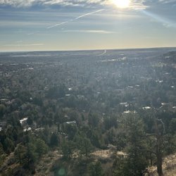
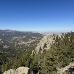
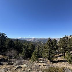
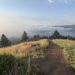
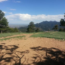
For all the years Ive been living in this area Im surprised it took me this long to visit. This area offers many different trails both for hiking and mtb. Many of the trails interconnect and offer spectacular views of the Flatiron Mountain Range. The main entrance is located by the corner of Highway 93 and 128, the parking lot is small and there is a small self serve dropbox by the information signage to deposit your $5 parking fee if youre not a resident of Boulder County. The trails are gravel and seem to be well maintained and vary in difficulty levels.

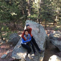
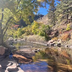
We headed to another trail location and yelped this one. It has free parking and public bathroom stalls...the stalls are not flushable and hand sanitizer only. Bring lots of water to drink. Good idea to bring a backpack for light snacks and liquids if you plan to hike far. It's also a good idea to hike early morning vs midday in July as it gets hot and not a lot of shade while hiking. Flatirons Vista has many Trail to go on. Great place for walking, hiking, bike riding and horse back riding. There's a main welcome map that gives you an idea how far the trails will be. The flatirons trails are much rockier and hillier for some serious cardio. I ended up walking the Greenbelt Platue as it was less hilly and not too rocky trail. You would have to cross the gate and street at the stop light. Keep in mind you are with nature so there will be flying grasshoppers and bees around. I didn't see any snakes but it says it's out there. So peaceful out here and a great way to just get away and be one with nature. Collect your thoughts... I've seen a lot of ppl bring their leashed dogs here and families hiking together. Overall a nice place to check out while you are here in Colorado if you don't want to spend money on entrance fees.

Spent a few hours hiking the flatirons loop! The trails can be slight muddy during the winter. I stopped by in April & close to the peak the trails were icy but still lots of people able to hike with sneakers or hiking boots. Micro spikes were not needed but doesn't hurt to be safe if the weather changes on you. The sites were beautiful and if you choose the flatiron 1&2 trail be prepared for some scrabbling to get to the top.

Fantastic trail. A little muddy today but nothing we couldn't deal with wearing hiking shoes. Absolutely no steep uphills or downhills. Dogs everywhere but all on leash. Also a lot of bikes on the trail, but very friendly and courteous. views were amazing. Most of the Mountain views were in the distance. Plenty of meadows and wildflowers. Public bathrooms at the beginning. read more


6 years ago
For all the years Ive been living in this area Im surprised it took me this long to visit. This area offers many different trails both for hiking and mtb. Many of the trails interconnect and offer spectacular views of the Flatiron Mountain Range. The main entrance is located by the corner of Highway 93 and 128, the parking lot is small and there is a small self serve dropbox by the information signage to deposit your $5 parking fee if youre not a resident of Boulder County. The trails are gravel and seem to be well maintained and vary in difficulty levels. read more


We headed to another trail location and yelped this one. It has free parking and public bathroom stalls...the stalls are not flushable and hand sanitizer only. Bring lots of water to drink. Good idea to bring a backpack for light snacks and liquids if you plan to hike far. It's also a good idea to hike early morning vs midday in July as it gets hot and not a lot of shade while hiking. Flatirons Vista has many Trail to go on. Great place for walking, hiking, bike riding and horse back riding. There's a main welcome map that gives you an idea how far the trails will be. The flatirons trails are much rockier and hillier for some serious cardio. I ended up walking the Greenbelt Platue as it was less hilly and not too rocky trail. You would have to cross the gate and street at the stop light. Keep in mind you are with nature so there will be flying grasshoppers and bees around. I didn't see any snakes but it says it's out there. So peaceful out here and a great way to just get away and be one with nature. Collect your thoughts... I've seen a lot of ppl bring their leashed dogs here and families hiking together. Overall a nice place to check out while you are here in Colorado if you don't want to spend money on entrance fees. read more


5 years ago
Spent a few hours hiking the flatirons loop! The trails can be slight muddy during the winter. I stopped by in April & close to the peak the trails were icy but still lots of people able to hike with sneakers or hiking boots. Micro spikes were not needed but doesn't hurt to be safe if the weather changes on you. The sites were beautiful and if you choose the flatiron 1&2 trail be prepared for some scrabbling to get to the top. read more


8 years ago
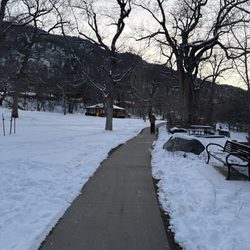
Easy and beautiful views of flatirons. We got to the trailhead by 10am today(Sunday 50 degree), parking lot is full and lucky we got a spot after a car leave. The other side of the parking lot is for horse trailer parking, by 12 noon after we finished hiking, cars also parking there. $5 fee for non Boulder residents. Some parts of the trails are narrow and shared with other hikers, trail runners and bikers. We saw a coyote today! The trails are dry and windy today. read more


6 years ago
12 years ago
10 years ago
More info about Flatirons Vista Trail
3439 S Foothills Hwy
Boulder, CO 80303
Directions
Hours
Outdoor Amenities
Ask the Community - Flatirons Vista Trail
Review Highlights - Flatirons Vista Trail


Why does Yelp recommend reviews?
1 review that is not currently recommended
The reviews below are not factored into the business's overall star rating.
3 years ago
Flatirons Vista Trail - hiking - Updated June 2026
Best of Boulder
People found Flatirons Vista Trail by searching for…
Scenic View in Boulder, Colorado
Scenic Overlook in Boulder, Colorado
Off Leash Dog Hikes in Boulder, Colorado
Walking Trails in Boulder, Colorado
Easy Hikes in Boulder, Colorado
Things to Do in Boulder, Colorado
Hiking Trails in Boulder, Colorado
Running Trails in Boulder, Colorado
Beautiful Views in Boulder, Colorado
Free Parking in Boulder, Colorado
Off Road Trails in Boulder, Colorado
Parks for Kids in Boulder, Colorado
Stroller Friendly Hikes in Boulder, Colorado
Stroller Walk in Boulder, Colorado
Natural Hot Springs in Boulder, Colorado
Lookout Points in Boulder, Colorado
Night Hike in Boulder, Colorado
Dog Friendly Hiking Trails in Boulder, Colorado
Hikes With Dogs in Boulder, Colorado
Fun Things to Do at Night in Boulder, Colorado
Mountain Biking in Boulder, Colorado
Trending Searches in Boulder, CO
Amusement Parks near Flatirons Vista Trail
Beaches near Flatirons Vista Trail
Black Owned Nail Salons near Flatirons Vista Trail
Boat Rental near Flatirons Vista Trail
Cliff Jumping near Flatirons Vista Trail
Creeks near Flatirons Vista Trail
Dog Friendly Trails near Flatirons Vista Trail
Fishing Spots near Flatirons Vista Trail
Free Kids Activities near Flatirons Vista Trail
Jet Ski Rental near Flatirons Vista Trail
Lakes near Flatirons Vista Trail
Outdoor Activities near Flatirons Vista Trail
Pick Your Own Farms near Flatirons Vista Trail
Public Shower near Flatirons Vista Trail
Rock Quarry near Flatirons Vista Trail
Running Trails near Flatirons Vista Trail
Scenic Drive near Flatirons Vista Trail
Secluded Spots near Flatirons Vista Trail
Soccer Store near Flatirons Vista Trail
Splash Pad near Flatirons Vista Trail
Strawberry Picking near Flatirons Vista Trail
Sunrise View near Flatirons Vista Trail
Swimming Holes near Flatirons Vista Trail
Swimming Lakes near Flatirons Vista Trail
Swimming Pools near Flatirons Vista Trail
Watch Sunset near Flatirons Vista Trail
Browse Articles
Browse Nearby
Browse Brands
Related Searches in Boulder, CO
Affordable Kayak Rental Services in Boulder, Colorado
Best Fishing Locations and Guides in Boulder, Colorado
Best Nature Trails for Hiking in Boulder, Colorado
Best Places for Horseback Riding in Boulder, Colorado
Check Out Off Road Trails in Boulder, Colorado
Discover Dog Friendly Trails to Explore in Boulder, Colorado
Discover Kid Friendly Hiking Trails in Boulder, Colorado
Discover Scenic Bike Paths in Boulder, Colorado
Discover Scenic Mountain Bike Trails Near Boulder, Colorado
Discover Scenic Waterfall Spots in Boulder, Colorado
Discover the Best Night Hike Trails in Boulder, Colorado
Dog-Friendly Hikes With Dogs in Boulder, Colorado
Enjoy Camping Adventures Around Boulder, Colorado
Enjoy Exciting Mountain Biking Adventures in Boulder, Colorado
Enjoy Kayaking Adventures in Boulder, Colorado
Enjoy River Tubing Adventures in Boulder, Colorado
Enjoy Tent Camping Spots Around Boulder, Colorado
Enjoy Water Activities and Fun in Boulder, Colorado
Enjoy a Beautiful Waterfall Hike in Boulder, Colorado
Enjoy the Best Picnic Spots and Ideas in Boulder, Colorado
Enjoy the Best Walking Path in Boulder, Colorado
Enjoy the Best Walking Trails in Boulder, Colorado
Exciting Cliff Jumping Spots in Boulder, Colorado
Experience Thrilling White Water Rafting in Boulder, Colorado
Explore Beautiful Parks and Green Spaces in Boulder, Colorado
Explore Easy Hikes Perfect for All in Boulder, Colorado
Explore Fun Activities to Do in Boulder, Colorado
Explore Popular Campgrounds Near Boulder, Colorado
Explore the Best Beach Spots in Boulder, Colorado
Explore the Best Boating Spots in Boulder, Colorado
Explore the Best Swimming Holes Around Boulder, Colorado
Explore the Best Trail Options in Boulder, Colorado
Family Friendly Hiking With Kids in Boulder, Colorado
Find Beautiful Views in Boulder, Colorado
Find Popular Ziplining Spots Around Boulder, Colorado
Find the Best Scenic View Locations in Boulder, Colorado
Great Places to Walk in Boulder, Colorado
Hiking Trails With Waterfalls in Boulder, Colorado
Off Leash Dog Hiking Trails in Boulder, Colorado
Plan a Scenic Drive Route Near Boulder, Colorado
Popular Outdoor Activities to Try in Boulder, Colorado
Popular Picnic Spots to Visit in Boulder, Colorado
Safe River Swimming Areas in Boulder, Colorado
Safe and Fun Parks for Kids in Boulder, Colorado
Top Climbing Spots and Gyms in Boulder, Colorado
Top Running Trails to Explore in Boulder, Colorado
Top Swimming Lakes to Enjoy in Boulder, Colorado
Top Swimming Spots and Pools in Boulder, Colorado
People who viewed Flatirons Vista Trail also viewed
Gregory Canyon
6 reviews
Boulder Flatirons
38 reviews
Flagstaff Mountain
27 reviews
Davidson Mesa Scenic Overlook
12 reviews
Betasso Preserve
3 reviews
Diamond Lake Trail
9 reviews
Eben Fine Park
14 reviews
White Ranch Open Space Park
26 reviews
Bald Mountain Scenic Area
3 reviews
Brainard Lake Recreation Area
33 reviews