Fisher Trail/Five Rivers Photos


More like Fisher Trail/Five Rivers
Recommended Reviews - Fisher Trail/Five Rivers
Start your review...

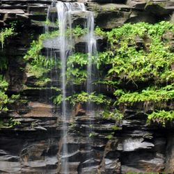
A Hidden Gem for a Peaceful, Scenic Hike! The Fisher Trail is an absolute gem! At just 0.66 miles, it's the perfect little escape into nature -- and it's so beautiful, I honestly could have kept hiking for miles. It opened in October 2022, and you can really tell it's a thoughtfully maintained trail. There are trailheads at 47 Fisher Boulevard and 106 Mason Lane, making access super convenient. The first half-mile, from Fisher Boulevard to a lovely viewing platform overlooking the Phillipinkill, is even accessible for those with mobility disabilities, with a well-graded crushed stone surface -- such an important and inclusive feature. From the viewing platform, the trail gets a bit more adventurous, heading down a steep slope into the ravine and connecting to the Wild Turkey Trail. The variety in terrain makes it interesting, and the views are just stunning. Part of the trail crosses a 35-acre parcel owned by the Mohawk Hudson Land Conservancy, managed in partnership with Five Rivers -- and it really shows in the care and preservation of the land. If you're looking for a peaceful, scenic walk that feels like a mini escape into the woods -- Fisher Trail is a must-visit. Highly recommend for a quick nature fix or as part of a longer adventure in the area! read more


More info about Fisher Trail/Five Rivers
47 Fisher Blvd
Slingerlands, NY 12159
Directions
Hours
Outdoor Amenities


Fisher Trail/Five Rivers - hiking - Updated June 2026
Best of Slingerlands
People found Fisher Trail/Five Rivers by searching for…
Hiking Trails in Slingerlands, New York
Beautiful Views in Slingerlands, New York
Scenic Overlook in Slingerlands, New York
Secret Spots in Slingerlands, New York
Things to Do in Slingerlands, New York
Places to Take Pictures in Slingerlands, New York
Walking Trails in Slingerlands, New York
Secluded Spots in Slingerlands, New York
Scenic View in Slingerlands, New York
Night Hike in Slingerlands, New York
Lookout Points in Slingerlands, New York
Running Trails in Slingerlands, New York
Swimming Holes in Slingerlands, New York
View Points in Slingerlands, New York
Skyline View in Slingerlands, New York
Waterfall in Slingerlands, New York
Romantic Views in Slingerlands, New York
Swimming Lakes in Slingerlands, New York
Scenic Drive in Slingerlands, New York
Off Leash Dog Hikes in Slingerlands, New York
Nature Parks in Slingerlands, New York
Sunrise View in Slingerlands, New York
Browse Nearby
BEST of Slingerlands, New York Restaurants near Fisher Trail/Five Rivers
BEST of Slingerlands, New York Things to Do near Fisher Trail/Five Rivers
BEST of Slingerlands, New York Coffee near Fisher Trail/Five Rivers
BEST of Slingerlands, New York Breakfast near Fisher Trail/Five Rivers
BEST of Slingerlands, New York Thrift Stores near Fisher Trail/Five Rivers