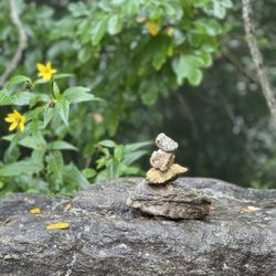
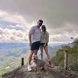
Dry Falls Photos


More like Dry Falls
Recommended Reviews - Dry Falls
Start your review...

Reviews With Photos
.")
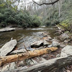
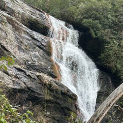
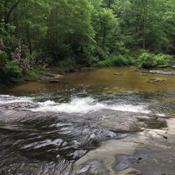
This is an easily accessible 75' waterfall on the Callasaja River in the Nantahala National Forest near Highlands, North Carolina. You can access the falls by walking down well-maintained stone steps from the small crowded parking lot ($3 parking fee, Sept, 2023). The falls go over an overhanging bluff which allows visitors to walk directly under the falls while keeping relatively dry. There are additional waterfalls worth visiting in the area so you can make this a day trip.

Update to my review of Dry Falls. Still love to visit here anytime I can. It's a stunning location. We had very low temperatures in late December for several days, so I knew I had to check out Dry Falls in the winter- frozen! Well, mostly frozen. There's still some Water flowing, but tons of icicles. I could not walk behind the falls this time because of the ice and my shoes would not keep me from sliding on the ice, but I did manage to get some fabulous photos!!

Hike no. 2 in the Nantahala National Forest was at Dry Falls. It is $3 per car to park so make sure you bring cash and fill out the envelope. It's an easy out-and-back hike that is 0.4 miles. The waterfall is beautiful and one of the coolest parts was being able to walk behind it. It's a must visit.

I love swinging into Dry Falls! Hubby grew up visiting the falls while camping in NC & TN and he introduced me about 5 years ago. The parking lot is small and gets full quickly especially during prime visiting times like the summer months. The fee to park is cheap and totally worth it. There are a few flights of stairs and sloped walkways to get down to the falls. Most people shouldn't have any issues on the short walk down. Don't let the walk stop you from experiencing the falls up close! Once down the stairs, you will be face to face with the beautiful waterfall known as Dry Falls. Thinking about just how much water constantly flows over those rocks is astonishing. One of the coolest parts, is walking behind the falls. You can get to the other side and stay dry, hence the name. You will get some of the mist that blows around which is feel nice on a hot day. If you love nature, make sure to stop by!

My buddy suggested we stop at Dry Falls on the way from Asheville to Atlanta and I am very glad we did. It was a scenic drive with a windy mountain road in, but it was all worth it. They offer about 30 parking places and it is a few stair flights down to a gorgeous waterfall. Once down there, you can walk behind the waterfall and around to the other side. It is a bit slick and wet, so make sure you are careful. The view is absolutely incredible and the roaring sound is a bit intimidating. I am really glad we stopped as it was a beautiful way to break up the road trip.


One of the prettiest dry falls i've seen in person! Not a long walk to the fall and railing everywhere to make sure you, your animals, your kids and even your parents don't fall haha. I went out at the perfect time with perfect weather right before rain set in. The breeze with the cool feel of being under the fall made all of my troubles i've ever felt just float away with the water at the bottom of the waterfall. Definitely a great experience for a waterfall lover and a tourist.

Beautiful waterfall-- but due to construction took a long while on winding mountain to get there -- but worth it. Going under the waterfall was very cool (cool looking and got splashed a bit) On way back-- Took a short cut someone recommended-Turtle Pond road -- mostly gravel -- memorable day!

January 14, 2017 was the last time I was here. At that time, I came with a group of hikers and nature lovers. This time, I dragged my husband to come with me since he's never been. We made the 2ish hours trip to check it out. Before we arrived, we stopped to have breakfast and check out the Sky Valley Overlook. The parking is small and was full. Luckily, there wasn't a long wait and we bagged a parking spot. It's $3 to park and it's the honor system. Please pay $3. The waterfalls is gorgeous and it's a very nice well maintenance place. Yes, there could be more parking space. I agree with that. You could hear how loud the waterfalls was. My husband was impressed with what he saw halfway. I told him to hold on as we get closer. It was gorgeous!!! So loud! Strong. Powerful. I captured a rainbow too. Sooooo cold going behind the waterfall. Couldn't get a great picture since the lighting was bad. One of the best waterfalls to take family and friends. Short distance. Paved. Come. You will not regret it. 256/2019


One of the most interesting and accessible falls in Western North Carolina When I was a child way back when and we would visit my Mother;s family outside of Sylva, we would occasionally come back this way on our way to Brevard.. I guess that is where I inherited the habit of not going and coming the same way on the same trip. The falls are about 4 - 5 miles North of Highlands on US64 and another 10 miles of so to Franklin. From Asheville about an hour away. When I was young, there was nothing but a gravel pull over to park your car and walk down a gravel path that occasionally washed out. Today the Forest Service has built a large parking lot with restroom facilities and places to have a picnic. For those who do not want to walk down to the falls, there is also a nice overlook or observation deck they have built. Still i would recommend taking the path down to and behind the Falls and experience to roar of the Cullasaja River as it cascades down the gorge. It's not a hard path and has been paved with handrails for convenience. One caution to photographers. There is considerable mist coming up from the river so take care to keep you lens dry otherwise you may have some unwanted elements in you picture. These pictures were taken in Early June and at this elevation, it more like early April. Really impressive during Autumn when the foliage turns and the gorge is filled with reds and yellows from the trees..

Awesome!!! This will be the most beautiful falls we have seen in this trip. You can walk behind the falls to get a lot of steam water mist. My eyes glass will be full of water vapor when walk behind the curtain of the water falls. It is awesome to see the water falls behind the curtain of sheet of water. It was beautiful at the front for deep falls. It was amazing to go behind the scene. The Dry Falls is about 3.6 of the US 64 from the intersection of Main Street and N 4 Street at Highlands, North Carolina. Also me the way you will see the Bridal Veil Falls than you will see huge parking lot to access this falls. The walk is easy for down hill stair way. Easy walk to behind the falls. I wonder why they call it Dry Falls. It was plenty of water during our visit. I would suggest visit them just after the raining season. The time we have visited this place is begin of June. This may be dry during the winter.

13 years ago
There are many fantastic waterfalls in North Carolina but Dry Falls is my personal fave. I'd say it's too good to be true - a picturesque falls that you can walk behind, flowing massive amounts of water at LOUD volume, all within a couple of minutes' walk down a paved path from a decent-sized parking lot that even has bathrooms! And did I mention that it's in the midst of a gorgeous forest scene with awesome mountain views and still more waterfalls? But if I say "too good to be true", it implies that there's some downside to all of the promised features. But I can't think of a single one...thinking...well, you can't live at Dry Falls. You have to leave at some point. I guess that's the downside. But if you can come to terms with that, this is well worth the quick diversion from the Atlanta-Asheville route. Make sure you're factoring in the smaller scale Bridal Veil Falls and, if you are the intrepid type, Cullasaja Falls. You get all that nature offers here - beauty but with a powerful punch. read more


One of the best waterfalls I've been to. There is so much to see from every angle. You can walk down and stand underneath the falls; view it from the sides; or view it from the very top. If you're driving along the scenic highway through the Highlands, don't miss the opportunity to stop here! read more


5 years ago
11 years ago
* S T U N N I N G * A must do! Access to get behind the falls. I've hiked plenty a mile to find a waterfall, and this is by far one of the most incredible, all-senses-satisfying sites I've ever seen in NC! About 1.5 hr drive from downtown Asheville. An easy walk (not a hike) on a paved walkway. Ample parking area, out house style toilets at parking area. read more


7 years ago
Absolutely beautiful! If you are in the area, this is a must see! Did not get to walk behind the falls because of the weather but it was a beautiful view! read more


Just a few minute drive from Highlands is this must-see. Good parking, steps and handrails make the trip up and down a medium-level challenge. You can walk all the way underneath the falls while still standing up. Prepare to get a little damp, but it's worth it! read more


6 years ago
4 years ago
4 years ago
8 years ago
Beautiful little waterfall right on the side of the highway. Great photo place of the falls and your ride. 5 minute ride from Highlands NC. read more

8 years ago
Not dry.. :) It is a short walk down a few steps and totally worth the steps! This fall was the coolest we've seen in the area! You can choose to admire from a distance or you can explore and walk behind the falls (which I recommend!) read more


4 years ago
This spectacular, and easily accessible, waterfall is one of the best natural attractions along Hwy 64 between Franklin and Highlands. From the parking lot, follow the wooden stairs down into the gorge for some incredible views, then continue along the short trail BEHIND the falls before heading back up. We did the entire walk in about 30 minutes on a busy October afternoon. The parking lot can get crowded during leaf season, but the falls are well worth the wait. read more


10 years ago
7 years ago

12 years ago
7 years ago
6 years ago
7 years ago
7 years ago
Very pretty! Definitely worth seeing. After you park, it's a very easy walk to the falls. You can even walk on the back side of the waterfall. read more


8 years ago
Beautiful waterfall, along a scenic highway. Kid friendly, but limited parking. Wish I would of brought some lunch! read more

8 years ago
Beautiful falls outside of Highlands, NC, along the Callasuja river. Definitely worth visiting, especially after a good rainfall. Located just off of highway 64, it's easily accessible for all ages. Has a parking lot and stairs, with hand rails to walk down to the falls, and even has a short path to walk behind the falls. read more


12 years ago
7 years ago
9 years ago
Absolutely GORGEOUS. We were so excited to find that this was so close to us while at a North Georgia wedding. We were able to drive for only about 20 minutes to get here, across the North Carolina line. The parking should really be reconsidered, as there was a very long line that was stopping up the highway in order to wait for a parking spot in the tiny, tiny lot. There were attendants, however, so that was helpful. You have the option to take a very short sidewalk to an overlook, should you not be able to handle stairs, or you can choose to take the trek down to the falls to get up close and personal. Of course, we took the trek, and there were several spots for gorgeous photo opportunities. You can even walk down and behind the falls, which was the first time I've been able to get that close to a waterfall, and honestly, it was such a great bucket list item to fill here. People were walking their dogs along behind the falls, tourists were taking photos, and children were giggling at the splashes you get standing close. It is such a charming place to visit, and it's FREE! read more


7 years ago
10 years ago
7 years ago
9 years ago
11 years ago
10 years ago
8 years ago
12 years ago
8 years ago
12 years ago
12 years ago
More info about Dry Falls
US 64/28 W
Highlands, NC 28741
Directions
Hours
Indoor Amenities
Outdoor Amenities
Ask the Community - Dry Falls
Review Highlights - Dry Falls


Why does Yelp recommend reviews?
8 reviews that are not currently recommended
The reviews below are not factored into the business's overall star rating.
2 years ago
3 years ago
6 years ago
11 years ago
6 years ago
9 years ago
12 years ago
9 years ago
Dry Falls - landmarks - Updated May 2026
Best of Highlands
People found Dry Falls by searching for…
Trending Searches in Highlands, NC
Baseball Fields near Dry Falls
Botanical Gardens near Dry Falls
Bounce House Rentals near Dry Falls
Floral Designers near Dry Falls
Landmarks & Historical Buildings near Dry Falls
Nurseries & Gardening near Dry Falls
Outdoor Furniture Stores near Dry Falls
Party Equipment Rentals near Dry Falls
Places To Take Pictures near Dry Falls
Scenic Restaurants near Dry Falls
Browse Nearby
Browse Brands
Related Searches in Highlands, NC
Affordable Kayak Rental Services in Highlands, North Carolina
Best Fishing Locations and Guides in Highlands, North Carolina
Best Fun Things to Do in Highlands, North Carolina
Best Lookout Points to Visit in Highlands, North Carolina
Best Places for Horseback Riding in Highlands, North Carolina
Best Spots for Star Gazing in Highlands, North Carolina
Best Things to Do on a Rainy Day in Highlands, North Carolina
Best Waterfalls and Swimming Holes in Highlands, North Carolina
Book Engaging Historical Tours in Highlands, North Carolina
Check Out Off Road Trails in Highlands, North Carolina
Discover Charming Historic Homes in Highlands, North Carolina
Discover Dog Friendly Trails to Explore in Highlands, North Carolina
Discover Family-Friendly Aquariums in Highlands, North Carolina
Discover Historic Sites and Places in Highlands, North Carolina
Discover Popular Photo Spots in Highlands, North Carolina
Discover Scenic Waterfall Spots in Highlands, North Carolina
Discover Top Boat Tours in Highlands, North Carolina for All Ages
Discover a Hiking Trail in Highlands, North Carolina
Discover the Best Beaches in Highlands, North Carolina
Discover the Best Night Hike Trails in Highlands, North Carolina
Discover the Best Planetarium Shows in Highlands, North Carolina
Dog-Friendly Hikes With Dogs in Highlands, North Carolina
Enjoy Arts & Entertainment in Highlands, North Carolina
Enjoy Camping Adventures Around Highlands, North Carolina
Enjoy Exciting Mountain Biking Adventures in Highlands, North Carolina
Enjoy Hiking Adventures in Highlands, North Carolina
Enjoy Kayaking Adventures in Highlands, North Carolina
Enjoy River Tubing Adventures in Highlands, North Carolina
Enjoy a Beautiful Waterfall Hike in Highlands, North Carolina
Enjoy the Best Tubing Experiences in Highlands, North Carolina
Enjoy the Best Walking Trails in Highlands, North Carolina
Exciting Cliff Jumping Spots in Highlands, North Carolina
Experience Stunning Sunset Views in Highlands, North Carolina
Experience Thrilling White Water Rafting in Highlands, North Carolina
Explore Beautiful Botanical Gardens in Highlands, North Carolina
Explore Beautiful Parks and Green Spaces in Highlands, North Carolina
Explore Family-Friendly Zoos and Wildlife in Highlands, North Carolina
Explore Free Things to Do Around Highlands, North Carolina
Explore Fun Activities to Do in Highlands, North Carolina
Explore Fun Field Trips in Highlands, North Carolina
Explore Popular Campgrounds Near Highlands, North Carolina
Explore Popular Scenic Overlook Points in Highlands, North Carolina
Explore Popular Scenic Views Near Highlands, North Carolina
Explore Top Art Galleries Located in Highlands, North Carolina
Explore Top Water Parks in Highlands, North Carolina Today
Explore Venues & Event Spaces in Highlands, North Carolina
Explore the Best Boating Spots in Highlands, North Carolina
Explore the Best Swimming Holes Around Highlands, North Carolina
Explore the Top Car Museum in Highlands, North Carolina
Family Friendly Hiking With Kids in Highlands, North Carolina