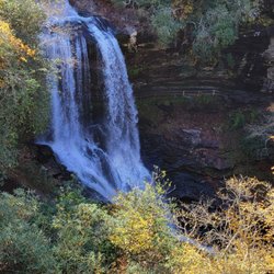
Big View Scenic Outlook Photos


More like Big View Scenic Outlook
Recommended Reviews - Big View Scenic Outlook
Start your review...

1 year ago
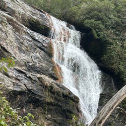
The nicest scenic overlook in the Cashiers/Highlands area, it's free. Really interesting shadow cast in the PM, but might be cool checking it out in the AM too. Plenty of space over to the right side of the road for you to pull over, but you need to cross the two lane road to snag pictures and it's tight so be mindful. read more


No one else here as the sun was thinking about setting so I had the view to myself. Peaceful and quiet other than the occasional passerby not stopping. This was one of the greatest views I've seen in some time. A long valley and near sunset, the light on the cliffside was beautiful. This is worth going out of your way to visit. [Review 20016 overall - 3456 in North Carolina - 991 of 2023.] read more
More info about Big View Scenic Outlook
US-64 & Rhody Ln
Highlands, NC 28741
Directions
Hours
Outdoor Amenities


Big View Scenic Outlook - parks - Updated May 2026
Best of Highlands
People found Big View Scenic Outlook by searching for…
Scenic Overlook in Highlands, NC
Beautiful Views in Highlands, NC
Lookout Points in Highlands, NC
Places to Take Pictures in Highlands, NC
Running Trails in Highlands, NC
Walking Trails in Highlands, NC
Secluded Spots in Highlands, NC
Jogging Trails in Highlands, NC
Park & Forests in Highlands, NC
Trending Searches in Highlands, NC
Baseball Fields near Big View Scenic Outlook
Boat Rental near Big View Scenic Outlook
Botanical Gardens near Big View Scenic Outlook
Bounce House Rentals near Big View Scenic Outlook
Campgrounds near Big View Scenic Outlook
Dog Friendly Trails near Big View Scenic Outlook
Floral Designers near Big View Scenic Outlook
Flower Shop near Big View Scenic Outlook
Lakes near Big View Scenic Outlook
Nurseries & Gardening near Big View Scenic Outlook
Outdoor Furniture Stores near Big View Scenic Outlook
Party Equipment Rentals near Big View Scenic Outlook
Pedicure near Big View Scenic Outlook
Photo Spots near Big View Scenic Outlook
Picnic Areas near Big View Scenic Outlook
Playgrounds near Big View Scenic Outlook
Pool Supplies near Big View Scenic Outlook
Public Shower near Big View Scenic Outlook
Rock Quarry near Big View Scenic Outlook
Rv Rental near Big View Scenic Outlook
Scenic Drive near Big View Scenic Outlook
Swimming Holes near Big View Scenic Outlook
Browse Articles
Browse Nearby
BEST of Highlands, North Carolina Coffee near Big View Scenic Outlook
BEST of Highlands, North Carolina Restaurants near Big View Scenic Outlook
BEST of Highlands, North Carolina Things to Do near Big View Scenic Outlook
BEST of Highlands, North Carolina Hiking near Big View Scenic Outlook
BEST of Highlands, North Carolina Breakfast near Big View Scenic Outlook
BEST of Highlands, North Carolina Shopping near Big View Scenic Outlook
Browse Brands
Related Searches in Highlands, NC
Best Parks for Parties and Events in Highlands, North Carolina
Best Water Parks for Kids in Highlands, North Carolina
Check Out Great Playgrounds in Highlands, North Carolina
Check Out Off Road Trails in Highlands, North Carolina
Discover Baseball Fields Around Highlands, North Carolina
Discover Lakes & Ponds to Explore in Highlands, North Carolina
Discover Popular Photo Spots in Highlands, North Carolina
Discover the Best Beaches in Highlands, North Carolina
Enjoy the Best Walking Trails in Highlands, North Carolina
Explore Beautiful Botanical Gardens in Highlands, North Carolina
Explore Family-Friendly Zoos and Wildlife in Highlands, North Carolina
Explore Free Picnic Areas Around Highlands, North Carolina
Explore Free Things to Do Around Highlands, North Carolina
Explore Fun Activities to Do in Highlands, North Carolina
Explore Landmarks & Historical Buildings in Highlands, North Carolina
Explore Parks With Pull Up Bars in Highlands, North Carolina
Explore Pickleball Courts in Highlands, North Carolina
Explore Popular Campgrounds Near Highlands, North Carolina
Explore Popular Picnic Areas Around Highlands, North Carolina
Explore Popular RV Parks Around Highlands, North Carolina
Explore Popular Recreation Centers Around Highlands, North Carolina
Explore Popular Scenic Overlook Points in Highlands, North Carolina
Explore Popular Scenic Views Near Highlands, North Carolina
Explore Scenic Lakes to Visit in Highlands, North Carolina
Explore Top Dog Parks in Highlands, North Carolina Near You
Explore Top Gyms in Highlands, North Carolina Now
Explore Top Water Parks in Highlands, North Carolina Today
Explore the Best Swimming Holes Around Highlands, North Carolina
Find Beautiful Views in Highlands, North Carolina
Find Top Skate Parks in Highlands, North Carolina for All Skill Levels
Find Top Skating Rinks in Highlands, North Carolina for All Ages
Find Top-Rated Waterfalls in Highlands, North Carolina Now
Find the Best Parks for Picnics in Highlands, North Carolina
Find the Best Swimming Pools in Highlands, North Carolina Today
Fun Things for Kids in Highlands, North Carolina
Great Places to Swim in Highlands, North Carolina
Have Fun at a Splash Pad in Highlands, North Carolina
Hiking Trails With Waterfalls in Highlands, North Carolina
Must-See Tourist Attractions Around Highlands, North Carolina
Picnic Areas With BBQ Pits Available in Highlands, North Carolina
Popular Fishing Spots to Explore in Highlands, North Carolina
Popular Kids Activities in Highlands, North Carolina
Popular Places to Take Pictures in Highlands, North Carolina
Popular Things to Do in Highlands, North Carolina
Top Hiking Trails to Explore in Highlands, North Carolina
Top Running Trails to Explore in Highlands, North Carolina
Top Swimming Lakes to Enjoy in Highlands, North Carolina
Top-Rated Basketball Courts to Play at in Highlands, North Carolina
People who viewed Big View Scenic Outlook also viewed
Dry Falls
82 reviews
Black Rock Mountain State Park
57 reviews
Caesars Head State Park
43 reviews
Little Tennesee River Greenway
2 reviews
Thompson River Waterfalls
2 reviews
Pisgah National Forest
74 reviews
Reedy Branch Falls Trailhead
4 reviews
Toxaway Falls
4 reviews
Highland Excursion
12 reviews
Daniel Ridge Falls
1 review