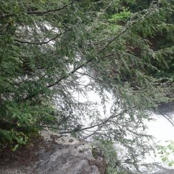
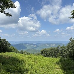
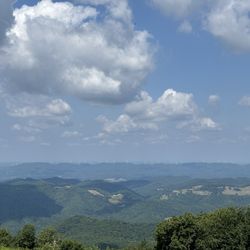
Dolly Sods Wilderness Photos


You might also consider
More like Dolly Sods Wilderness
Recommended Reviews - Dolly Sods Wilderness
Start your review...

Access to the preservation is on a narrow gravel road, with lots of uneven places. I do not recommend if you don't have AWD or have an aversion to narrow spaces and heights, one side of the road is a high drop off. I also recommend taking a map of the preservation and trails with you, as the signs posted can be confusing. That being said once you arrive and find your way to the trail you have selected, the trails are very well maintained and marked, the scenery is spectacular. I did notice signs posted that hunting is allowed Oct -Mar and hikers should wear bright clothing during this time, I think I would just prefer to avoid the area during this time. The area was also a WWII training ground, signs are posted for visitors not to touch any ordnance they may find. read more


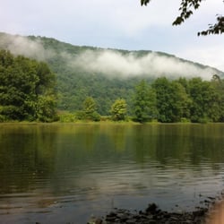
One of the premier hiking locations on the east coast. The sods are a high altitude tundra like terrain at about 4000 feet of elevation. The wilderness features many different trails and lots of primitive camping. Access is from forest road 75, a gravel and dirt road that is mostly inaccessible in winter. The trails are well marked but not blaised, which can be a problem if you intend to night hike. Water is plentiful but has high levels of iron. Some of the trails are very boggy, especially the Dobbins grade trail. You are warned,! This area is so popular that on weekends it can be very crowded. Parking is limited so go early. read more

2 years ago
4 years ago
11 years ago
We did the Blackbird Knob Trail. Beautiful hike, but it was really muddy, wet, and rocky. Apparently, that's how it is all the time. It's not a hard hike, but it is important to wear proper shoes. We had a 10 month old lab puppy with us, who really enjoyed it. There were quite a few campers out there too, however I think the terrain was a little too muddy and rocky for me. A day hike was just fine for us. Beautiful view of the mountains and it sure was wild and wonderful! The drive up may take a while. You're pretty much on a narrow and bumpy dirt road for 30 minutes going 20mph. It sure will test your suspensions on your car! The Dolly Sods area is huge, so my review is only for the Blackbird Knob Trail. We've heard many wonderful things about the Dolly Sods, so we will definitely check out the other trails the next time we are here. read more


6 years ago
9 years ago
8 years ago
9 years ago
10 years ago
9 years ago
More info about Dolly Sods Wilderness
Ask the Community - Dolly Sods Wilderness


Why does Yelp recommend reviews?
1 review that is not currently recommended
The reviews below are not factored into the business's overall star rating.
9 years ago
Dolly Sods Wilderness - hiking - Updated July 2026
Best of Davis
People found Dolly Sods Wilderness by searching for…
Things to Do in Davis, West Virginia
Fishing in Davis, West Virginia
Hiking Trails in Davis, West Virginia
Campgrounds in Davis, West Virginia
Scenic Overlook in Davis, West Virginia
Scenic Views in Davis, West Virginia
Hiking With Kids in Davis, West Virginia
Off Road Trails in Davis, West Virginia
Sunset View in Davis, West Virginia
Beautiful Views in Davis, West Virginia
Attractions in Davis, West Virginia
Night Hike in Davis, West Virginia
Canyoneering in Davis, West Virginia
Walking Trails in Davis, West Virginia
Secret Spots in Davis, West Virginia
Bike Paths in Davis, West Virginia
Visitor Centers in Davis, West Virginia
Easy Hikes in Davis, West Virginia
Swimming Lakes in Davis, West Virginia
Camping Sites in Davis, West Virginia
Trending Searches in Davis, WV
Day Trips near Dolly Sods Wilderness
Off Road Trails near Dolly Sods Wilderness
Public Shower near Dolly Sods Wilderness
River Swimming near Dolly Sods Wilderness
River Tubing near Dolly Sods Wilderness
Scenic Overlook near Dolly Sods Wilderness
Soccer Store near Dolly Sods Wilderness
Splash Pad near Dolly Sods Wilderness
Strawberry Picking near Dolly Sods Wilderness
Swimming Lakes near Dolly Sods Wilderness
Watch Sunset near Dolly Sods Wilderness
Browse Articles
Browse Brands
Related Searches in Davis, WV
Best Fishing Locations and Guides in Davis, West Virginia
Best Fun Things to Do in Davis, West Virginia
Best Nature Trails for Hiking in Davis, West Virginia
Best Places for Horseback Riding in Davis, West Virginia
Best Spots for Star Gazing in Davis, West Virginia
Best Waterfalls and Swimming Holes in Davis, West Virginia
Check Out Off Road Trails in Davis, West Virginia
Discover Dog Friendly Trails to Explore in Davis, West Virginia
Discover Popular Bike Trails in Davis, West Virginia
Discover Popular Photo Spots in Davis, West Virginia
Discover a Hiking Trail in Davis, West Virginia
Discover the Best Night Hike Trails in Davis, West Virginia
Dog-Friendly Hikes With Dogs in Davis, West Virginia
Enjoy Camping Adventures Around Davis, West Virginia
Enjoy Exciting Mountain Biking Adventures in Davis, West Virginia
Enjoy the Best Picnic Spots and Ideas in Davis, West Virginia
Experience Stunning Sunset Views in Davis, West Virginia
Explore Beautiful Parks and Green Spaces in Davis, West Virginia
Explore Bike Rentals Throughout Davis, West Virginia
Explore Easy Hikes Perfect for All in Davis, West Virginia
Explore Family-Friendly Zoos and Wildlife in Davis, West Virginia
Explore Jet Skis for Sale or Rent in Davis, West Virginia
Explore Popular Campgrounds Near Davis, West Virginia
Explore Popular RV Parks Around Davis, West Virginia
Explore Popular Scenic Overlook Points in Davis, West Virginia
Explore the Best Boating Spots in Davis, West Virginia
Explore the Best Trail Options in Davis, West Virginia
Family Friendly Hiking With Kids in Davis, West Virginia
Find Beautiful Views in Davis, West Virginia
Find Popular Ziplining Spots Around Davis, West Virginia
Find Top Dog Swimming Spots in Davis, West Virginia
Find Top-Rated Disc Golf in Davis, West Virginia
Find the Best Playgrounds to Visit in Davis, West Virginia
Find the Best Swimming Pools in Davis, West Virginia Today
Great Places to Swim in Davis, West Virginia
Hiking Trails With Waterfalls in Davis, West Virginia
Plan a Scenic Drive Route Near Davis, West Virginia
Popular Fishing Spots to Explore in Davis, West Virginia
Popular Kids Activities in Davis, West Virginia
Popular Picnic Spots to Visit in Davis, West Virginia
Popular Things to Do in Davis, West Virginia
Relax at Natural Hot Springs Near Davis, West Virginia
Safe River Swimming Areas in Davis, West Virginia
Top Paddleboarding Activities in Davis, West Virginia
Top Playgrounds for Kids to Enjoy in Davis, West Virginia
Top Running Trails to Explore in Davis, West Virginia
Top Swimming Lakes to Enjoy in Davis, West Virginia
Top Things to Do With Kids in Davis, West Virginia
Top-Rated Basketball Courts to Play at in Davis, West Virginia
People who viewed Dolly Sods Wilderness also viewed
Lost River State Park
13 reviews
Spruce Knob - Seneca Rocks National Recreation Area
33 reviews
Spruce Knob Lake Campground
6 reviews
Douglas Falls
2 reviews
Spruce Knob
12 reviews
Back Ridge Shadows Campground
2 reviews
Nrocks Outdoor Adventures
45 reviews
Brighton Park
1 review
Blackwater Outdoor Adventures
20 reviews
North Fork Mountain Inn
2 reviews