Cancel

    Open app

    Search

    Douglas Falls

    5.0 (2 reviews)

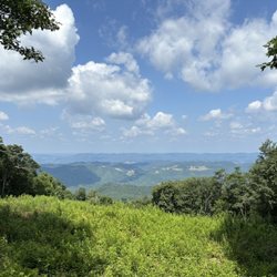
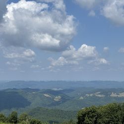
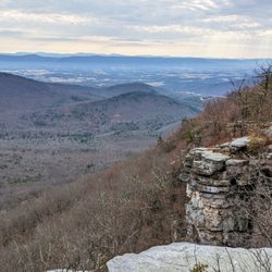
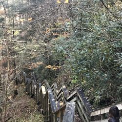
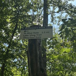
    Douglas Falls Photos

    You might also consider

    Recommended Reviews - Douglas Falls

    Your trust is our priority, so businesses can't pay to alter or remove their reviews. Learn more about reviews.
    Yelp app icon
    Browse more easily on the app
    Review Feed Illustration
    Photo of J G.
    0
    1
    0

    7 months ago

    Helpful 1
    Thanks 0
    Love this 0
    Oh no 0

    4 years ago

    Excellent falls and historic site of the mining place; it is a bit on the wild side in terms of getting down to the waterfall.

    Helpful 0
    Thanks 0
    Love this 0
    Oh no 0

    Verify this business for free

    Get access to customer & competitor insights.

    Verify this business

    Spruce Knob - Seneca Rocks National Recreation Area

    Spruce Knob - Seneca Rocks National Recreation Area

    4.6(33 reviews)
    22.6 mi

    Seneca Rocks Trail. A number of years ago, my husband and I visited the educational Discovery…read moreCenter for the Seneca Rocks National Recreation Area, and got a great view of the Seneca Rocks from the parking lot. But, it was late in the day on a Sunday and we had a long drive ahead of us, so we decided not to attempt to hike up the trail, but we put it as yet another item on our bucket list. We returned to the area in Sept, 2025, specifically to attempt to do the hike. No concerns as to whether my husband would be able to do it, but I have to admit that I was apprehensive as to whether I could! The brochures say that it's 1.5 miles each way (up, and then back down) and you gain almost 850' in elevation. And, did I mention that I'm in my 60s, NOT a regular hiker, and with a medical condition that affects my balance? Nonetheless, my husband and I donned our hiking boots, put on some sunscreen, packed a picnic lunch, snacks, and water, and my hiking stick -- and we were on our way! The trail is wide and well-maintained and, as others have mentioned, has steep sections, especially in the switchbacks towards the top. It's a steady climb up, and my Fitbit registered some intense exercise, but my heart rate never reached its peak category. Given my balance issues, having my walking stick and an occasional hand from my husband, especially on the descent in steep areas with roots or stones, were helpful. I tried not to be discouraged by the two very fit runners who raced by us, recognizing that the majority of hikers and dogs on leash were panting at least to some degree! There are occasional benches, especially towards the bottom, and signs pointing out ecological features. There's an observation deck at the top, with gorgeous views of the valley below, as well as shaded benches to enjoy our picnic lunch. You can't see the rocks from the observation deck. However, some hikers scramble over some additional rocks for more views though signage warns that this can be dangerous. I'm happy to report that my husband and I both completed the hike, and we are now able to cross that item off of our joint bucket list. We celebrated our accomplishment by getting some ice cream at Yokum's, just down the street! Admission to the Seneca Rocks National Recreation Area and parking is free. Staff in the Discovery Center are exceptionally helpful. There are picnic tables and restrooms at the base, and the Seneca Shadows Campground is about a mile down the street.

    Literally a quick trip ( sadly), recommended by a friend, en route from Cass to Elkins…read more Absolutely beautiful and would have loved to have hiked this beauty. Hope to return one day ( Florida resident), preferably again in the fall to see the colors. Nature center sadly closed because of the government shut down.

    Photos
    Spruce Knob - Seneca Rocks National Recreation Area
    Spruce Knob - Seneca Rocks National Recreation Area - Another view of the top.

    Another view of the top.

    Spruce Knob - Seneca Rocks National Recreation Area

    See all

    Valley Falls State Park

    Valley Falls State Park

    5.0(18 reviews)
    35.5 mi

    Valley Falls State Park. Fairmont, WV. My husband and I visited this scenic West Virginia State…read morePark in Sept, 2025. Its highlight is a series of four cascading WATERFALLS on the Tygart Valley River that are easily accessible by a short path from the parking lot. There are large flat rocks right next to the falls, allowing for scenic photographs but no swimming. (Fishing with license and whitewater kayaking are allowed). Fun Fact: this is one of the sites for West Virginia's "Almost Heaven" swings, installed by the state's Department of Tourism across the state for photo opps. This particular swing has the falls in the background. (As of late 2025, there are 51 swings in the state). We had a unique experience at the park in that we were approached by a park volunteer in an ATV offering us a ride down to the falls, and then continuing along some park paths with his commentary about the history of the site as a 19th-century mill town, and pointing out some gristmills. Both park admission and the ATV ride were free although we did give the volunteer a tip. There are 18 miles of trails for hiking and mountain biking, ranging from easy to difficult. We didn't do any hiking on this visit, but did eat our picnic lunch at one of the conveniently located picnic table. There is a gift shop on-site, as well as clean restrooms. It's also a site on WV's Waterfalls Trail, wherein you can earn prizes for checking it at specific WV waterfalls. Note that this is a day-use park, so no camping is allowed. Wi-Fi connectivity is low to non-existent. We approached the park from the south, near Pruntytown, WV, and while the distance was short (about 12 miles), it took us about 25 minutes to reach because of curvy roads. On our return, we went to Tygart Lake State Park, via Grafton, where we camped for the night.

    Tony and I went for a nice hike today at Valley Falls State Park in Fairmont WV…read more The Park is lovely and the Park is free to enjoy with plenty of picnic tables, restrooms, grills, playground, and the gorgeous waterfalls

    Photos
    Valley Falls State Park
    Valley Falls State Park
    Valley Falls State Park

    See all

    Dolly Sods Wilderness

    Dolly Sods Wilderness

    3.7(11 reviews)
    12.9 mi

    Access to the preservation is on a narrow gravel road, with lots of uneven places. I do not…read morerecommend if you don't have AWD or have an aversion to narrow spaces and heights, one side of the road is a high drop off. I also recommend taking a map of the preservation and trails with you, as the signs posted can be confusing. That being said once you arrive and find your way to the trail you have selected, the trails are very well maintained and marked, the scenery is spectacular. I did notice signs posted that hunting is allowed Oct -Mar and hikers should wear bright clothing during this time, I think I would just prefer to avoid the area during this time. The area was also a WWII training ground, signs are posted for visitors not to touch any ordnance they may find.

    One of the premier hiking locations on the east coast. The sods are a high altitude tundra like…read moreterrain at about 4000 feet of elevation. The wilderness features many different trails and lots of primitive camping. Access is from forest road 75, a gravel and dirt road that is mostly inaccessible in winter. The trails are well marked but not blaised, which can be a problem if you intend to night hike. Water is plentiful but has high levels of iron. Some of the trails are very boggy, especially the Dobbins grade trail. You are warned,! This area is so popular that on weekends it can be very crowded. Parking is limited so go early.

    Photos
    Dolly Sods Wilderness - Creek crossing with our pup

    Creek crossing with our pup

    Dolly Sods Wilderness - Creek crossing with our pup

    Creek crossing with our pup

    Dolly Sods Wilderness

    See all

    Douglas Falls - hiking - Updated May 2026

    Loading...
    Loading...
    Loading...