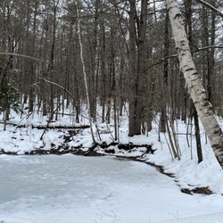
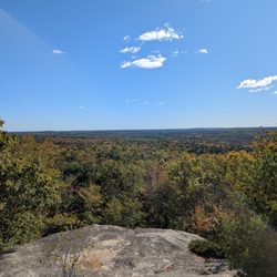
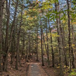
David Rancourt River Preserve Photos


More like David Rancourt River Preserve
Recommended Reviews - David Rancourt River Preserve
Start your review...

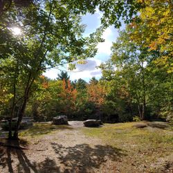
This is such a fantastic spot! We had NO IDEA it was here, until looking at my All Trails app for a quick walk between appts. I don't know Lewiston very well, but, this was a big surprise to my partner, too, and he's very familiar with the area. We truly enjoyed the serenity and ease of the walk! The loop was perfect for the time frame we had! We'll definitely be going back. The reason I gave it 4 stars, is there really isn't any parking, perhaps 3-4 spots. Also, until the vegetation grows in, the ugly back side of business buildings is very visible. Also, unfortunately, there was a lot of litter (we picked up some, but didn't have a bag to collect). It's so distressing when folks don't respect public offerings such as this! read more


More info about David Rancourt River Preserve
Tall Pines Dr
Lewiston, ME 04240
Directions
Hours
Outdoor Amenities


David Rancourt River Preserve - hiking - Updated May 2026
Best of Lewiston
People found David Rancourt River Preserve by searching for…
Walking Trails in Lewiston, ME
Running Trails in Lewiston, ME
Jogging Trails in Lewiston, ME
Off Leash Dog Hikes in Lewiston, ME
Fitness & Instruction in Lewiston, ME
Off Road Trails in Lewiston, ME
Scenic Night View in Lewiston, ME
Fun Things to Do for a Birthday in Lewiston, ME
Places to Take Pictures in Lewiston, ME
Waterfalls and Swimming Holes in Lewiston, ME
Arts & Entertainment in Lewiston, ME
Trending Searches in Lewiston, ME
Baseball Fields near David Rancourt River Preserve
Botanical Gardens near David Rancourt River Preserve
Bounce House Rentals near David Rancourt River Preserve
Campgrounds near David Rancourt River Preserve
Dog Friendly Things To Do near David Rancourt River Preserve
Floral Designers near David Rancourt River Preserve
Flower Shop near David Rancourt River Preserve
Garden Center near David Rancourt River Preserve
Lakes & Ponds near David Rancourt River Preserve
Nurseries & Gardening near David Rancourt River Preserve
Outdoor Activities near David Rancourt River Preserve
Outdoor Furniture Stores near David Rancourt River Preserve
Parks near David Rancourt River Preserve
Party Equipment Rentals near David Rancourt River Preserve
Pedicure near David Rancourt River Preserve
Photo Spots near David Rancourt River Preserve
Picnic Areas near David Rancourt River Preserve
Places To Take Pictures near David Rancourt River Preserve
Pool Supplies near David Rancourt River Preserve
Rock Quarry near David Rancourt River Preserve
Running Trails near David Rancourt River Preserve
Rv Rental near David Rancourt River Preserve
Spray Tanning near David Rancourt River Preserve
Sunrise View near David Rancourt River Preserve
Swimming Holes near David Rancourt River Preserve
Table And Chair Rentals near David Rancourt River Preserve
Browse Articles
Browse Nearby
BEST of Lewiston, Maine Things to Do near David Rancourt River Preserve
BEST of Lewiston, Maine Restaurants near David Rancourt River Preserve
BEST of Lewiston, Maine Coffee near David Rancourt River Preserve
BEST of Lewiston, Maine Beaches near David Rancourt River Preserve
BEST of Lewiston, Maine Breakfast near David Rancourt River Preserve
BEST of Lewiston, Maine Shopping near David Rancourt River Preserve
Browse Brands
Related Searches in Lewiston, ME
Affordable Kayak Rental Services in Lewiston, Maine
Best Fishing Locations and Guides in Lewiston, Maine
Best Fun Things to Do in Lewiston, Maine
Best Places for Horseback Riding in Lewiston, Maine
Discover Dog Friendly Beaches Near Lewiston, Maine
Discover Dog Friendly Trails to Explore in Lewiston, Maine
Discover Popular Photo Spots in Lewiston, Maine
Discover Public Beaches to Visit in Lewiston, Maine
Discover a Hiking Trail in Lewiston, Maine
Discover the Best Night Hike Trails in Lewiston, Maine
Discover the Best Running Track in Lewiston, Maine
Dog-Friendly Hikes With Dogs in Lewiston, Maine
Enjoy Exciting Mountain Biking Adventures in Lewiston, Maine
Enjoy Kayaking Adventures in Lewiston, Maine
Enjoy a Beautiful Waterfall Hike in Lewiston, Maine
Enjoy the Best Walking Trails in Lewiston, Maine
Experience Stunning Sunset Views in Lewiston, Maine
Explore Beautiful Parks and Green Spaces in Lewiston, Maine
Explore Bike Rentals Throughout Lewiston, Maine
Explore Easy Hikes Perfect for All in Lewiston, Maine
Explore Fun Activities to Do in Lewiston, Maine
Explore Popular Campgrounds Near Lewiston, Maine
Explore Popular Scenic Overlook Points in Lewiston, Maine
Explore Popular View Points Around Lewiston, Maine
Explore Scenic Lakes to Visit in Lewiston, Maine
Explore Secret Spots Worth Visiting in Lewiston, Maine
Explore Top Dog Parks in Lewiston, Maine Near You
Explore the Best Beach Spots in Lewiston, Maine
Explore the Best Boating Spots in Lewiston, Maine
Explore the Best Swimming Holes Around Lewiston, Maine
Family Friendly Hiking With Kids in Lewiston, Maine
Find Beautiful Views in Lewiston, Maine
Find Fun Kids Activities Outdoor in Lewiston, Maine
Find Fun Things to Do With Kids in Lewiston, Maine
Find Top Dog Swimming Spots in Lewiston, Maine
Find the Best Playgrounds to Visit in Lewiston, Maine
Great Places to Swim in Lewiston, Maine
Hiking Trails With Waterfalls in Lewiston, Maine
Off Leash Dog Hiking Trails in Lewiston, Maine
Perfect Spots to Watch Sunset in Lewiston, Maine
Plan a Scenic Drive Route Near Lewiston, Maine
Popular Kids Activities in Lewiston, Maine
Popular Outdoor Activities to Try in Lewiston, Maine
Popular Picnic Spots to Visit in Lewiston, Maine
Popular Things to Do in Lewiston, Maine
Top Paddleboarding Activities in Lewiston, Maine
Top Playgrounds for Kids to Enjoy in Lewiston, Maine
Top Swimming Lakes to Enjoy in Lewiston, Maine
People who viewed David Rancourt River Preserve also viewed
Thorncrag Bird Sanctuary
5 reviews
Woodbury Sanctuary
1 review
Mt Pisgah Conservation Area
2 reviews
Sunnyside Park
2 reviews
Cathance River Nature Reserve Trails
4 reviews
Hacker's Hill Preserve
1 review
Gardiner Waterfront Park
2 reviews
Highland Lake Boat Launch
1 review
Pejepscot Falls
1 review
Shepard’s Farm Family Preserve
1 review