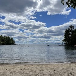
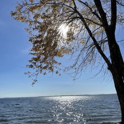
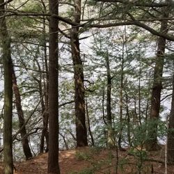
Cancel

    Open app

    Search

    Riverwalk

    3.5 (4 reviews)

    Riverwalk Photos

    Recommended Reviews - Riverwalk

    Your trust is our priority, so businesses can't pay to alter or remove their reviews. Learn more about reviews.
    Yelp app icon
    Browse more easily on the app
    Review Feed Illustration

    11 months ago

    Helpful 1
    Thanks 0
    Love this 0
    Oh no 0

    9 years ago

    Helpful 30
    Thanks 0
    Love this 28
    Oh no 0

    8 years ago

    Helpful 0
    Thanks 0
    Love this 0
    Oh no 0
    Photo of Dominik D.
    320
    5947
    11113

    9 years ago

    Helpful 1
    Thanks 0
    Love this 2
    Oh no 0

    Verify this business for free

    People searched for Hiking 210 times last month within 15 miles of this business.

    Verify this business

    Mount Apatite

    Mount Apatite

    (3 reviews)

    Mount Apatite is unlike many other networks of trails as it offers some really interesting…read moreabandoned quarries. These mining areas used to be rich in apatite and tourmaline, but mostly are abundant in quartz and mica now. You will for sure see families chipping away at boulders and panning in the water for gems and even gold. There was an area where you could crawl into the ground/under the enormous boulders and see a car-sized quartz amidst tree roots. Very, very cool. As was the beach-like/snow-like slag piles and the opportunity to get pretty high on the quarry ledges. I do a lot of hiking/nature walks/trail exploration and my biggest frustration with Mount Apatite is the underwhelming amount of signage. For example, there's no kiosk with a trail map; this wouldn't necessarily be a problem if the trails were properly marked, but they're not and there's only two: blue and red. The blue trail is 99% marked; the red trail is 99% not marked. Despite being seasoned, we still somehow ended up in people's backyards more than once. Just some "Private Property" signs on those dead end trails, or even some wooden signs pointing to the quarries or height of land would be appreciated. Also - the abundance of trash was pretty off-putting. CARRY IN, CARRY OUT. The amount of plastic bottles, Dunkin cups, and food wrappers was astounding. All in all, I probably wouldn't explore this particular spot again, but definitely love that such an expansive, unique spot exists in Auburn.

    Need an adventure that not only takes you past military vehicles, hikes you up a small mountain,…read morebut also gives you a mining experience?? This is the place! With a short walk straight up the main trail you will find numerous dig spots that hold numerous types of rocks including Apatite, Tourmaline, and Quartz. Some of the quarries have filled with water and are speckled with frogs and other creatures. This became a fascination to my friend's son who I had with me as the frogs were in their froglet stage. He spent time counting and recounting how many he could see (we got up to 40), skipping rocks, and walking around the edge to explore. We hit up several dig spots, each one of them was cooler than the previous according to my buddy. There was many "Whoa, Miss Mary, check this one out". We brought garden tools to chip away and dig up our treasures. Our last spot we hit also had a nice view of the Auburn area. On the way down we explored one of the many side trails that many mountain bikers use. I guess I see a reason to coming back soon!

    Widgeon Cove Trail - Parallel plank path.

    Widgeon Cove Trail

    (2 reviews)

    I don't know what it's like to be a fairy or a gnome, and I'm often jealous of their woodland based…read morelifestyles (houses made in and of trees, drinking water out of flowers, riding on the back of squirrels... you know what I'm talking about). Widegon Cove Trail, however, has given me a sneak peek into that world. This unexpectedly beautiful path is a wonderfully maintained loop that cuts through thick, tall forest and circles past a cove with lovely pine tree and water views regardless of tide (although low tide offers more bird watching). It's well marked, and the trail itself is charming...at some points the ground is lined on either side with fallen trees to keep you on the path, parallel planks, and stone walkways too. Want to stop and take it all in? There are many wooden benches to stop and take it all in from. Does this sound like every other trail? Maybe. But there's really something charming and whimsical about this particular one. I don't know if it's the variety of trees, the ravine like parts, the moss and mushrooms, the abundance of wildlife, but I felt like I spent my entire walk (which was admittedly short; the whole loop is maybe half a mile?) smiling... and expecting Flora, Fauna, and Merryweather to come out of nowhere and begin singing to me.

    Follow this well maintained trail through woodlands to a beautiful view of Widgeon Cove…read more The parking lot is on the left heading when heading out of Brunswick and has enough space for four cars. The dirt was still loose near the road and I needed a slight angle to get out of the parking lot. There is the another one of the HHLT trails just before you get to this trail. If you are looking to lengthen your hike, you can walk or drive up to the other parking lot to check out the other trail. The following is taken from: www.hhltmaine.org/conserved-land/public-access/widgeon-cove-trail/ Ownership: Harpswell Heritage Land Trust trail on privately owned land Features: hiking, scenic view, benches, dogs allowed Length: .6 mile loop with cutoff trail Difficulty: moderate Hiking Time: 30 minutes Click here to download a trail map and brochure. Description: This half-mile loop trail is the perfect way to take in beautiful Widgeon Cove on Harpswell Sound. The path winds through woodlands, across ravines and along the shoreline where there is a dramatic view of the cove. At this scenic viewpoint, visitors can enjoy a picnic with family and friends, take pictures or just sit quietly to observe waterfowl, wading birds and other wildlife that frequent the cove. The Widgeon Cove Trail is part of the 88-acre Dunning Farm Conservation Easement. This privately owned property will remain forest and working farmland forever. Directions: From the intersection of Rt 123 and Bath Rd at Bowdoin College in Brunswick, follow Rt 123 south for 7.4 miles. Immediately after the Wilson's Cove Trail parking lot on the right, look for the Widgeon Cove Trail parking lot on the left. Visitor Guidelines: Carry in, carry out. Pedestrian use only. No overnight parking. No open fires. No camping. Dogs must be on a leash. Carry out all dog waste. Please respect wildlife, neighbors and other users. This trail is on private property. Please respect the owner's privacy. Power driven mobility devices are not allowed.

    Bradbury Mountain State Park

    Bradbury Mountain State Park

    (32 reviews)

    From my original review: "'You know what I love about this place? It's low risk, high reward.'" We…read moreoverheard an older woman tell her husband this as they approached the summit. And as we stretched out on the rocks enjoying our picnic in the the warm sun, taking in the view of what seemed to be endless forests, bodies of water, and islands, we couldn't have agreed more." A decade later this is still true. If you're looking for an easygoing, very accessible way to go hiking and get some fresh air while wandering Maine's woods, take in the changing leaves of autumn or the abundance of blossoms and wildflowers in the spring, Bradbury - located just thirty minutes from Portland - is hard to beat. According to their website, Bradbury Mountain State Park was one of the original five state parks in the state of Maine, acquired by the Federal government in 1939. The mountain is open year round from 9am until sunset and offers a variety of hiking trails that range from very, very easy ("wide gradual ascents", "well packed and fairly flat") to slightly more challenging ("steepest ascent, but not difficult to hike", "areas with sharp turns"), from .2 miles to 1.5 miles (or more if you want to build your own adventure here - which is very easy to do because this state park's trails are now abundantly well marked; expect lots of maps throughout to let you know where you are AND lots of wooden signs pointing you in the right direction). You could easily do it all in one half day or break up your walk and come back another time, especially considering it's an easy, convenient mountain with an elevation of just 485 feet. Dogs are allowed on leashes, horses are allowed on certain trails. There are bathrooms. You can check out an old cattle pound. Explore for geocaches. It's a cute little mountain, and I'm so happy it's right in (proverbial) our backyard.

    I remember going here as a kid and I took my youngest son almost a decade ago. We wanted to do the…read moresummit trail and climb Bradbury Mountain. Definitely not a big challenge but it was fun. I grew up in Lewiston so this park is close by. I will have to take John next time we're in Maine. Lots of other trails to explore.

    Androscoggin Riverlands State Park

    Androscoggin Riverlands State Park

    (1 review)

    Maine Trip #1…read more "Something will have gone out of us as a people if we ever let the remaining wilderness be destroyed ... We simply need that wild country available to us, even if we never do more than drive to its edge and look in." ― Wallace Stegner, The Sound of Mountain Water Androscoggin Riverlands State Park (ARSP) first came to my attention while in Maine visiting my family. I had never heard of it before, and when I did some research, I found out why. ARSP opened six years ago, but hardly anyone was using this amazing park. A year ago, they put up more trail signs in order to encourage people to visit, in the hopes that they won't be so nervous about getting lost in the 2,700 acres, 12 miles of river frontage, and 22 miles of trails. History: The Androscoggin River is the 3rd largest river in Maine, and it begins in the mountains of New Hampshire. The Native Americans camped and fished for at least 9,000 years, and they gave the river its name--meaning "plenty of fish." Thanks to riverfront industries, the Androscoggin River became one of the ten most polluted rivers in the country back in the 1960s, but thankfully, the Clean Water Act in 1972 helped water quality improved tremendously. Amenities: * Toilet (outhouse--these things are probably way better than portable toilets. Open-air and wood building makes for no odor. * Large, dirt parking lot * No fee * ATV riding * Canoeing * Cross-country skiing * Fishing * Hiking (trails) * Horseback riding * Hunting (except Sundays) * Kayaking (two water landings) * Off-road biking * Picnicking * Snowmobiling * Snowshoeing * Watchable wildlife * Carry In-Carry Out * Pets welcome (on a leash at all times) * 8 old foundations show the community that existed here before 1927 I had a wonderful time hiking the Homestead Trail. It has several different terrain and lots to see. Unfortunately, I didn't know exactly how far the trail would go, so I turned around. (I now have a trail map and will post it.) At one point, I did lose cell signal so be prepared for that. Make sure you bring bug spray! I didn't see a single soul while I was on my hike, which is wonderful for me. I love the solitude and the "wilderness" at ARSP. I think you will too.

    Mt Pisgah Conservation Area

    Mt Pisgah Conservation Area

    (2 reviews)

    I feel the need to preface all of my nature reviews with this: being 90% forested and having around…read more3500 miles of coastline, Maine (and NH) has a tremendous amount of spaces, walkways, paths, and trails of all kinds and of all levels. There's something for everyone. What I'm reviewing is how a spot compares to similar outdoor spots in my personal opinion. Being in nature - and remembering to carry in, carry out - is always five stars! :) Parking? Yes. Loop trail? Yes. Well marked signs? Yes. Element of surprise? Yes. This is a gem of a hike. And it's proof that just when you think you know Maine... you don't. Will I ever run out of incredible places to explore here? Mt Pisgah proves I won't. I had never heard of this spot before, but was doing research for somewhere to play outside near the Augusta area, and this came up. It was everything I was looking for: 2 to 4 miles, meandering through the forest, and absolutely outstanding views at the top. I took Blueberry Trail (1.3 miles) which was mostly a very windy path through woodlands; what makes it so special, though, is the wild blueberries that grow near the top. From the informational sign: "...In natural settings native highbush blueberries are typically found in areas with wet, acidic, organic soils. Mt Pisgah, where highbush blueberries occur, does not resemble these preferred habitats. At this site, the highbush blueberries are found in an upland forest with dry soil and no nearby water source. It is unclear how the highbush blueberries came to be in this less than ideal habitat." TLDR: There are magical blueberries here. When I reached the top I climbed up the historic fire tower for impressive 360 degree views of the surrounding area. To come down from the summit there are two options: Tower Trail (which is about .7 miles) which passes through rich forest (expect lots of wooden planks over streams) OR the access road which is a straight shot on a well groomed, relatively accessible (think stroller-friendly) road back up and back from the parking lot. Side note: Ledges Trail, 1.4 miles, adds steps but not views. (From the informational sign at the top of the mountain: "In Hebrew, Pisgah means a lookout or place with a view, and refers to the place on Mt Nebo from which Moses looked out over the promised lands. In the 19th century, before the fire tower was constructed, the summit of Pisgah was an open pasture that provided panoramic views. Mt Pisgah has a rich agricultural history. Old stone walls, second growth pine and hardwood forest, and gnarly sugar maples with tap holes tell the story of intensive land clearing, pasturing, cultivation, and farm abandonment.")

    A nice 1-2.5 hour hike (depending on which trails one takes), especially for winter hiking, and a…read moregreat panoramic view atop the high scalable tower.

    Riverwalk - hiking - Updated May 2026

    Loading...
    Loading...
    Loading...