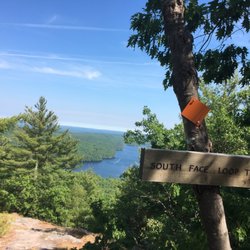
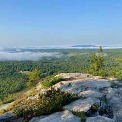
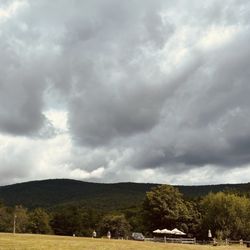
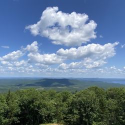
Cancel

    Open app

    Search

    Hacker's Hill Preserve

    5.0 (1 review)

    Hacker's Hill Preserve Photos

    You might also consider

    More like Hacker's Hill Preserve

    Recommended Reviews - Hacker's Hill Preserve

    Your trust is our priority, so businesses can't pay to alter or remove their reviews. Learn more about reviews.
    Yelp app icon
    Browse more easily on the app
    Review Feed Illustration

    8 years ago

    Helpful 0
    Thanks 0
    Love this 0
    Oh no 0

    Ask the Community - Hacker's Hill Preserve

    Verify this business for free

    People searched for Hiking 322 times last month within 15 miles of this business.

    Verify this business

    Bri-Mar Trail

    Bri-Mar Trail

    4.0
    (1 review)
    2.9 mi

    I feel the need to preface all of my nature reviews with this: being 90% forested and having around…read more3500 miles of coastline, Maine has a tremendous amount of spaces, walkways, paths, and trails of all kinds and of all levels. There's something for everyone. What I'm reviewing is how a spot compares to similar outdoor spots in my personal opinion. Being in nature - and remembering to carry in, carry out - is always five stars! :) Parking? *Extremely* limited. Loop trail? No. Well marked signs? Sporadically.. Element of surprise? Kind of. There's no view from the summit of this mountain. It's just a sign in some trees that says RATTLESNAKE MTN, ELEV, 1035FT. That being said: the views from the trail (which is around 2.5 miles back and out again) up to the summit - specifically the second ledge you'll come to - are absolutely stunning! It looks out over Panther Pond, Sebago Lake, Crescent Lake, and into Maine's mountains. No matter what time of year you come, it's really something special. (That being said, there really is no reason to walk the extra half mile to the summit, unless you're the completionist/achievement hunter type I guess... I mean, I am). The ledges overlooking the scenic views can be slippery when wet, so please be careful! Some other things to know: 1. There's maybe four parking spaces here, and they *will* tow if you aren't in one of them. 2. Dog are *not* allowed. 3. This has some mild rooty areas, but I wouldn't say it's very rock-scrambly.

    Photos
    Bri-Mar Trail
    Bri-Mar Trail
    Bri-Mar Trail

    See all

    Castle In the Clouds

    Castle In the Clouds

    4.0
    (126 reviews)
    43.0 mi

    Winter lunch at the Castle was so fun! Tables located in historic converted stable at the carriage…read morehouse. Set menu including starter and entree with n/a drink and gratuity at a reasonable cost. Food was excellent as was the service. Highly recommend- note reservations are required

    The place was amazing, very beautiful and views for days! The staff were very nice and informative…read more Now the not so good things: 1. It was very hot the day and you are forced immediately off the trolley to sit in a glassed in pouch that was 112 degrees for 20 minutes, which sets the tone of the experience in a negative way. You view the mansion hot and sweaty, which stinks (Pun intended). Even if it wasn't hot, people should have the option to skip the video. 2. The trolly is supposed to cycle every 15 minutes (trolly even said it on the way up). We waited over 30 minutes. 3. Some guests were chastised for things that could have been easily avoided by putting up signs. If you don't want people doing things which seem perfectly acceptable to do, put a sing up or put it at the end of your 20 minute video. I think the guests who were talked down too felt embarrased and it was unnecessary. 4. When you drive up to the attraction, there is parking, by the cafe. We parked, got out, and had to go up to some people working in the park to find that we had to continue driving up the mountain to get to the carriage house. Are signs that expensive? "Keep driving to see Castle In The Clouds" or "This way to see Castle in the Clouds".

    Photos
    Castle In the Clouds
    Castle In the Clouds
    Castle In the Clouds

    See all

    Douglas Mountain

    Douglas Mountain

    3.7
    (3 reviews)
    10.4 mi

    I feel the need to preface all of my nature reviews with this: being 90% forested and having around…read more3500 miles of coastline, Maine has a tremendous amount of spaces, walkways, paths, and trails of all kinds and of all levels. There's something for everyone. What I'm reviewing is how a spot compares to similar outdoor spots in my personal opinion. Being in nature - and remembering to carry in, carry out - is always five stars! :) Parking? Yes. Loop trail? Kind of. Well marked signs? Kind of. Element of surprise? No. When I think about hikes in Maine I need to do again, want to do again, would suggest others do... Douglas Mountain is unfortunately not one of them. For a few reasons: 1. There's no real view at the summit; there's a large stone observation tower that's pretty cool that you can climb up to see maybe a 160° view of the Maine Lakes Region (mountains, bodies of water, etc.). However, unless you're at the top of the tower (which always has a large number of wasps, by the way), you can't see anything at all because of the tree coverage. 2. If you take Eagle Scout (orange) from the parking lot, the first part is a really lovely walk in the woods. It then becomes a much more strenuous uphill hike. You need to stick on this trail to reach the top of the mountain, but it becomes confusing near Nature Loop Trail --- there's a misleading path, that's not part of the trail system, that it seems people have made overtime in search of a shortcut. We watched about ten people follow each other into the woods on one of these, then doubleback when they realized they weren't on Eagle Scout anymore. After you get to the top you can go down Woods or Ledges trail... but they both end on a dead end road with private homes. It's underwhelming. 3. We didn't see anyone pay the $3 suggested donation (to help maintain the trails). So that's a bummer; on the flipside, people were very respectful and patient about taking turns going up the stone tower so there wasn't overcrowding there. 4. If I wanted something similar, honestly I think Bradbury or Mt. Agamenticus are much better choices. Here's what I can say about Douglas Mountain: have you ever seen a man take his chickens hiking before? Because I have.

    it's a pretty view but not the best i've ever seen. you can see mount washington from the top of…read morethe stone tower. the stone tower had a lot of wasps/hornets. it said the hike was a mile up and a mile down but my apple watch said the total (up AND down) was only 0.8 miles. nice hike though.

    Photos
    Douglas Mountain
    Douglas Mountain
    Douglas Mountain

    See all

    Jagolinzer Preserve

    Jagolinzer Preserve

    5.0
    (4 reviews)
    17.0 mi

    Holy green guacamole, folks -- what an adorable hike for some recreational activity. Eight thumbs…read moreup from me. (SAYS THE OCTOPUS!!!) If you must know, Eugene: this loop's difficulty was easy-to-moderate. Moderate; only because there are a few steep inclines/declines & lots of exposed roots throughout. Otherwise, super charming trail -- at time of this post (8.24.25), there was a story book; 'The Wicked Big Toddlah' displayed along the trail 4 people 2 read. That was a fun touch that must have been added by someone who likes fun things. Saco River = the midway point -- and guess what?! -- there's a rope swing there!!! Splish-splash -- take a swing, miss thing! Cool lil' waterfall to observe, as well. FYI: it's in the distance & it comes up towards the end of the loop. You can access it, however, by moving your bod down a fairly steep woodland surface. (Be careful, Uncle Todd!) Lots of pine needles around, too -- but also, hello, it's the woods! Call me Ranger Rick -- but I really enjoyed this hiking loop. Fam said 'bravo ' too!

    Great time walking the preserve with my husband and dog. Don't be scared off by the "no…read moretrespassing" sign at the end of the road, like us. We saw that sign, despite Google maps telling us we arrived, and continued driving. We pulled off and decided to try again and sure enough, the parking lot and trail is JUST down the road slightly. Just past the no trespassing sign. The trail is extremely steep in 2 spots so I can't imagine visiting after it's freezing/icy/snow covered, unless you use snowshoes. Pretty view of the Saco River. Lots of parking.

    Photos
    Jagolinzer Preserve
    Jagolinzer Preserve
    Jagolinzer Preserve

    See all

    Donnabeth Lippman Park

    Donnabeth Lippman Park

    5.0
    (2 reviews)
    9.3 mi

    This is a great little trail to take your kiddos on. There's a playground, a story walk (that…read morechanges monthly), beautiful water views and an easy to follow trail around the pond. If you take a little detour off the story walk, you'll even find a cool teepee shaped bunch of sticks leaning against a tree. Children love to explore this area. It's not so far off the path that you'd ever get lost. In between the first few pages of the story walk, when you have an opportunity to go straight, do so. I promise it's only a few feet down the path. Can't miss it!

    I wasn't expecting so much from this little park right off Route 302 (it's located on a dirt road…read morejust after the Westbrook Pool & Spa; there's a large granite sign at the mouth of the road, and you've probably passed it a million times - I know I have - but once you see it, you'll know exactly where this gem is forever)! Donnabeth Lippman Park - formerly known as Chaffin Pond Preserve - is 123 acre mostly wooded area that surrounds a 10 acre pond that's apparently great for fishing. I came here for a walk in the woods and was delighted to find that there was more than meets the eye: there's a family-friendly (you could easily take a stroller here - it's packed earth and not very root-y), totally accessible to all abilities, story book trail with a giant "Once Upon A Time" sign inviting you into the woods (how magical and fantastical is that?). Once you're finished, you can walk back to the parking lot from here via the yellow trail or you can take that same trail and follow it up alongside the pond, through the woods, then back down around the opposite side of the water (side note: I love loop trails - who wants to double back and see the same things?). A red trail deviates off to Mud Pond, and a green trail just adds an extended path through the forest before reconnecting to yellow. All of it is perfectly marked! It's a wonderful walking trail and if I lived nearby I could see this also being a solid spot for a good run! Admittedly, after heavy rain or during spring you should expect it to be quite muddy. No hunting allowed here, so it's a good spot for year round enjoyment (for those of you who are looking for a new snowshoeing spot!); there's an abundance of picnic tables overlooking the pond, a swing set, a big playground area, and plenty of green space to stretch out on. Again - what an unexpectedly great spot hidden in plain sight!

    Photos
    Donnabeth Lippman Park
    Donnabeth Lippman Park
    Donnabeth Lippman Park

    See all

    Hacker's Hill Preserve - hiking - Updated July 2026

    Loading...
    Loading...
    Loading...