China Flats Photos


You might also consider
More like China Flats
Recommended Reviews - China Flats
Start your review...

Reviews With Photos


A great hike in the outskirts of the suburbs. Don't be fooled by the daunting tall dry mountain that looms ahead, looks can be decieving, once on the trail your local adventure becomes more lush as you progress. Just past the top of the incline lies lush meadows with mature trees, cool winds, a few caves and stellar views of T.O, Oxnard, Moorpark and even Simi Valley. NOTE: watch out for the mountain bike riding dads, they are huffing and puffing through their spandex laden mid life crisis all over them thar hills, so leave a wide berth.

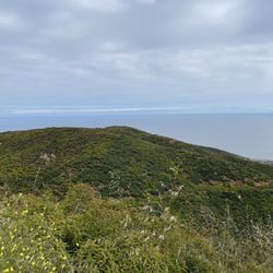
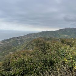
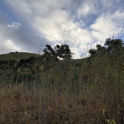
Within Oak Park, California you will be able to discover the China Flat loop which is a 3.9 mile trail. Trail can be accessed of Lindero Canyon Road between King James Court and Wembly Avenue. According to All Trails, this hike is a moderately challenging route due to a steady uphill climb to the peak which is an elevation gain of over 1,000 feet high. This loop provides expansive views, cool rock formations (including partial caves for pictures) and various plants. Springtime is a great time to check out this hike with the bountiful plants in full view. On the trail, you can commonly see wildlife including snakes and lizards. Mind you the snakes blend in well- so be on the lookout. During springtime you will see baby snakes abound. As the trail is not shaded- bring plenty of water, a good hat, and put on some suntan lotion! Happy Hiking! read more


5 years ago
Great spot with good views. Short hike up to a good spot with great view. Would recommend for easy hiking and fast escape. read more

5 years ago
12 years ago
A great hike in the outskirts of the suburbs. Don't be fooled by the daunting tall dry mountain that looms ahead, looks can be decieving, once on the trail your local adventure becomes more lush as you progress. Just past the top of the incline lies lush meadows with mature trees, cool winds, a few caves and stellar views of T.O, Oxnard, Moorpark and even Simi Valley. NOTE: watch out for the mountain bike riding dads, they are huffing and puffing through their spandex laden mid life crisis all over them thar hills, so leave a wide berth. read more

6 years ago
8 years ago
9 years ago
I love this hike!!!!! There are so many options once you're on it. Everyone you run in to is friendly (most have been hiking it for YEARS!!!) and will help you navigate or plan your trip. You get a good amount of elevation in a short amount of time without it feeling like it's just one steep incline. It's a solid workout for a newbie and old hands can run it and challenge themselves as well. If you are new to hiking, I would not describe this as the absolute easiest, but it is doable. Early morning is my favorite so I can watch the sun come over the mountain and it's too cool for the snakes to be out. If you bring a dog, be mindful of coyotes. I've never seen one, but I have a little dog and I'm warned often. I see tons of bunnies and lizards every time. This is not great for young kids or stroller friendly at all. Most people do not use hiking gear, but if you struggle with balance (the trail is not smooth which is fun) or just prefer, there are people who use trekking poles. Coming down does take some coordination, but as you become familiar it gets easier. There are a number of people who run it and make it look easy. It still challenges me. There are a couple steeper inclines, but it's a nice mix for when you need the break. Enjoy!!! read more


More info about China Flats
1399 King James Ct
Oak Park, CA 91377
Directions
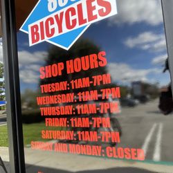
Hours
Outdoor Amenities
Ask the Community - China Flats
Review Highlights - China Flats
You might also consider


China Flats - hiking - Updated July 2026
Best of Oak Park
People found China Flats by searching for…
Hiking Trails in Oak Park, California
Beautiful Views in Oak Park, California
Scenic View in Oak Park, California
Abandoned in Oak Park, California
Walking Trails in Oak Park, California
Off Road Trails in Oak Park, California
Scenic Overlook in Oak Park, California
Watch Sunset in Oak Park, California
Stroller Walk in Oak Park, California
Hiking Trails Kid Friendly in Oak Park, California
Sunset View in Oak Park, California
Fun Things to Do in Oak Park, California
Sunset in Oak Park, California
Running Trails in Oak Park, California
Lakes & Ponds in Oak Park, California
Secret Spots in Oak Park, California
Photo Spots in Oak Park, California
Trails in Oak Park, California
Dog Friendly Trails in Oak Park, California
Secluded Spots in Oak Park, California
Trending Searches in Oak Park, CA
Black Owned Nail Salons in Oak Park, CA
Dog Friendly Trails in Oak Park, CA
Jet Ski Rental in Oak Park, CA
Lookout Points in Oak Park, CA
Mountain Biking in Oak Park, CA
Off Road Trails in Oak Park, CA
Outdoor Activities in Oak Park, CA
Places To Walk Around in Oak Park, CA
River Swimming in Oak Park, CA
Scenic Night View in Oak Park, CA
Scenic Overlook in Oak Park, CA
Secluded Spots in Oak Park, CA
Strawberry Picking in Oak Park, CA
Swimming Holes in Oak Park, CA
Browse Nearby
BEST of Oak Park, California Coffee near China Flats
BEST of Oak Park, California Restaurants near China Flats
BEST of Oak Park, California Things to Do near China Flats
BEST of Oak Park, California Breakfast near China Flats
BEST of Oak Park, California Parks near China Flats
BEST of Oak Park, California Horseback Riding near China Flats
Browse Brands
Related Searches in Oak Park, CA
Affordable Bike Repair Services in Oak Park, California
Affordable Bike Tune Up Services in Oak Park, California
Affordable Cheap Bike Tune Up Services in Oak Park, California
Affordable Kayak Rental Services in Oak Park, California
Affordable Road Bike Rental in Oak Park, California
Best Dirt Bike Riding Spots in Oak Park, California
Best Dog Hiking Trails Around Oak Park, California
Best Electric Bike Rental Services in Oak Park, California
Best Fishing Locations and Guides in Oak Park, California
Best Nature Trails for Hiking in Oak Park, California
Best Places for Horseback Riding in Oak Park, California
Best Sledding Spots and Fun in Oak Park, California
Check Out Off Road Trails in Oak Park, California
Convenient Bike Sharing Programs in Oak Park, California
Discover Dog Friendly Trails to Explore in Oak Park, California
Discover Easy Hiking Trails Near Oak Park, California
Discover Kid Friendly Hiking Trails in Oak Park, California
Discover Popular Bike Tours in Oak Park, California
Discover Popular Bike Trails in Oak Park, California
Discover Scenic Bike Paths in Oak Park, California
Discover Scenic Mountain Bike Trails Near Oak Park, California
Discover Walking Parks in Oak Park, California Near You
Discover a Hiking Trail in Oak Park, California
Discover the Best Night Hike Trails in Oak Park, California
Dog-Friendly Hikes With Dogs in Oak Park, California
Enjoy Biking Adventures Around Oak Park, California
Enjoy Camping Adventures Around Oak Park, California
Enjoy Hiking Adventures in Oak Park, California
Enjoy Kayaking Adventures in Oak Park, California
Enjoy Off Leash Dog Hikes in Oak Park, California
Enjoy Scenic Dirt Bike Trails Around Oak Park, California
Enjoy Scenic Places to Walk in Oak Park, California
Enjoy Tent Camping Spots Around Oak Park, California
Enjoy a Beautiful Waterfall Hike in Oak Park, California
Enjoy the Best Walking Path in Oak Park, California
Enjoy the Best Walking Trails in Oak Park, California
Exciting Snow Tubing Experiences in Oak Park, California
Explore BMX Bike Shops Near Oak Park, California
Explore Beautiful Parks and Green Spaces in Oak Park, California
Explore Bike Rentals Throughout Oak Park, California
Explore Cycling Stores in Oak Park, California
Explore Easy Hikes Perfect for All in Oak Park, California
Explore Electric Bikes Available in Oak Park, California
Explore Fun Activities to Do in Oak Park, California
Explore Popular Campgrounds Near Oak Park, California
Explore Popular Dog Walking Trails in Oak Park, California