Capitol Gorge Photos


You might also consider
More like Capitol Gorge
Recommended Reviews - Capitol Gorge
Start your review...

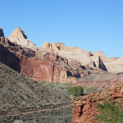
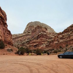
Found at the end of the Scenic Drive, Capitol Gorge begins with a dirt road that weaves through the beautiful rocks and mountains of Capitol Reef. While the scenic drive in and of itself was wonderful, this dirt road to the Capitol Gorge trailheads had that beat. We drove this in a compact car without any issue, just make sure to take it slow as there are some tight, blind turns on this two-way road. If it's busy, parking can be a bit difficult at the end of the road to hike the trails. We came to hike to The Tanks, and the trail to the beginning of the The Tanks portion is super easy. You'll get to see some petroglyphs as well as the Pioneer Register - which is a cool section of rocks with signatures dating back 100+ years. There's plenty of shade in this area as you're walking between two mountain walls, and it can get pretty windy. I'd recommend bringing a jacket for this area if you're going on cooler days. The actual The Tanks hike we had planned to do was super disappointing. This 0.2 miles add-on is probably considered a moderate hike. While it had nice views, there was nothing special about the views, and you would be better off spending your time at another one of the better hikes in Capitol Reef. The other part of the Capitol Gorge Trail I previously discussed is worth it, just not the additional hike to The Tanks. read more


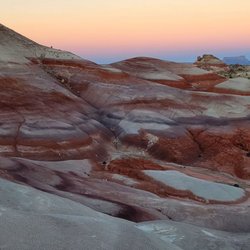
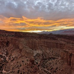
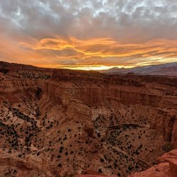
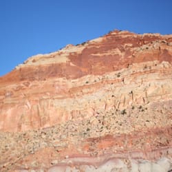
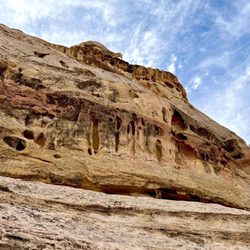
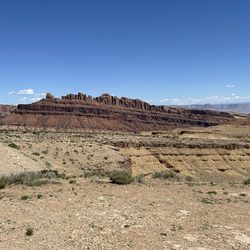
This is the wondrous Capitol Gorge area of Capitol Reef National Park at the end of the paved road portion of the Scenic Drive. This Capitol Gorge is fantastic for grasping the true essence of what makes Capitol Reef NP so special. The red rocks and canyon cliffs are simply stunning! I was visiting here in late July 2021 and unfortunately the overcast skies did darken the scenic setting somewhat, but I was still able to capture some beautiful examples of vintage Utah scenery. I'd put the Scenic Drive to arrive at this Capitol Gorge along with hiking Chimney Rock Trail as 2 of the best activities I did while exploring the park. The Scenic Drive starts right beside the Visitor Center and runs for 10 miles each way into the heart of the Capitol Reef landscape. Along the drive there'll be plenty of opportunities to pull your car off to the side, get out and snap amazing picture moments including standing at Capitol Gorge. Also of note...the Scenic Drive runs on paved road for about the first 7 - 8 miles and the last 2 - 3 miles are set on dirt/gravel road. Unfortunately, I had a compact car with me and didn't want to chance driving on the rough road in this remote part of the country. So...after stopping here at Capitol Gorge, I turned around and headed back the 7 - 8 miles towards the Visitor Center. It is a $20 fee to drive the Scenic Road, otherwise to enter and do anything within Capitol Reef it's absolutely free! You pay an attendant during normal business hours that they're open but when the Visitor Center closes, they use the "honor system" and ask you to drop the $20 into a box as proof of payment. Btw, the Visitor Center is great for buying souvenirs and picking up a park pamphlet and map of all the trails. I highly recommend stopping at the VC for any questions you may have and general advice about exploring around. Lastly, while in this Capitol Gorge area...I'd suggest hiking the Grand Wash Trail as well as the Rim Overlook Trail for 2 different, yet unique perspectives for appreciating Capitol Reef from high above and also down below in between the rugged canyon walls. Alright well, this is the Capitol Gorge section of Capitol Reef National Park! read more


10 years ago
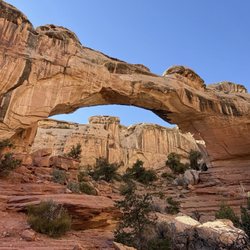
Hike this 2 mile round-trip hike to see early 1900s pioneer sginatures, an interesting canyon, potholes/tanks and fantastic sandstone views (if you hike all the way to the tanks). There is no doubt that this is one of the finest short easy day hikes in the national park. read more


More info about Capitol Gorge


Capitol Gorge - hiking - Updated July 2026
Best of Torrey
Browse Brands
Related Searches in Torrey, UT
Best Fishing Locations and Guides in Torrey, Utah
Best Lookout Points to Visit in Torrey, Utah
Best Nature Trails for Hiking in Torrey, Utah
Best Places for Horseback Riding in Torrey, Utah
Best Spots for Star Gazing in Torrey, Utah
Check Out Off Road Trails in Torrey, Utah
Discover Dog Friendly Trails to Explore in Torrey, Utah
Discover Popular Bike Trails in Torrey, Utah
Discover Popular Photo Spots in Torrey, Utah
Discover Scenic Creeks to Explore in Torrey, Utah
Discover Scenic Mountain Bike Trails Near Torrey, Utah
Discover Top Nature Parks to Visit in Torrey, Utah
Discover a Hiking Trail in Torrey, Utah
Discover the Best Fishing Lake in Torrey, Utah
Discover the Best Night Hike Trails in Torrey, Utah
Dog-Friendly Hikes With Dogs in Torrey, Utah
Enjoy Camping Adventures Around Torrey, Utah
Enjoy Tent Camping Spots Around Torrey, Utah
Enjoy the Best Picnic Spots and Ideas in Torrey, Utah
Experience Stunning Sunset Views in Torrey, Utah
Explore Beautiful Parks and Green Spaces in Torrey, Utah
Explore Bike Rentals Throughout Torrey, Utah
Explore Free Picnic Areas Around Torrey, Utah
Explore Fun Activities to Do in Torrey, Utah
Explore Nature Spots Around Torrey, Utah
Explore Popular Boat Charters Near Torrey, Utah
Explore Popular Campgrounds Near Torrey, Utah
Explore Popular RV Parks Around Torrey, Utah
Explore Popular Scenic Overlook Points in Torrey, Utah
Explore Scenic Lakes to Visit in Torrey, Utah
Explore Secret Spots Worth Visiting in Torrey, Utah
Explore the Best Trail Options in Torrey, Utah
Family Friendly Hiking With Kids in Torrey, Utah
Find Beautiful Views in Torrey, Utah
Find Cozy Camping Cabins in Torrey, Utah
Find Fun Kids Activities Outdoor in Torrey, Utah
Find the Best Scenic View Locations in Torrey, Utah
Locate a Public Shower Facility in Torrey, Utah
Perfect Spots to Watch Sunset in Torrey, Utah
Plan Nature Center Visits in Torrey, Utah
Plan a Scenic Drive Route Near Torrey, Utah
Popular Things to Do in Torrey, Utah
Relax at Natural Hot Springs Near Torrey, Utah
Safe and Fun Parks for Kids in Torrey, Utah
Top RV Campgrounds to Visit in Torrey, Utah
Top Running Trails to Explore in Torrey, Utah
Top Things to Do With Kids in Torrey, Utah
Top Things to Do With Teenagers in Torrey, Utah
People found Capitol Gorge by searching for…
Places to Take Pictures in Torrey, Utah
Off Road Trails in Torrey, Utah
Beautiful Views in Torrey, Utah
Running Trails in Torrey, Utah
Dog Friendly Trails in Torrey, Utah
Visitor Centers in Torrey, Utah
Swimming Lakes in Torrey, Utah
Parks for Kids in Torrey, Utah
Walking Trails in Torrey, Utah
Hiking With Kids in Torrey, Utah