Cancel

    Open app

    Search

    Cathedral Valley

    4.7 (3 reviews)

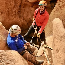
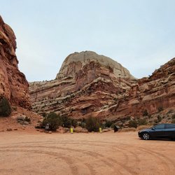
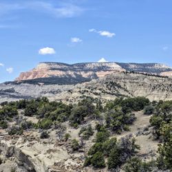
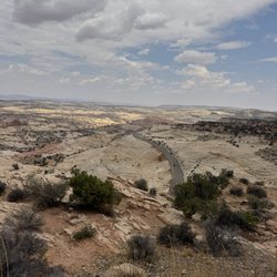
    Cathedral Valley Photos

    Recommended Reviews - Cathedral Valley

    Your trust is our priority, so businesses can't pay to alter or remove their reviews. Learn more about reviews.
    Yelp app icon
    Browse more easily on the app
    Review Feed Illustration
    Photo of Joe T.
    0
    48
    0

    3 years ago

    This is the only place to stay for 50 miles. Clean, family owned. Rooms quite attractive. EVs can plug into 110V. No good near by.

    Helpful 0
    Thanks 0
    Love this 0
    Oh no 0
    Photo of Peter N.
    89
    84
    72

    16 years ago

    Helpful 5
    Thanks 0
    Love this 3
    Oh no 0

    8 years ago

    Helpful 0
    Thanks 0
    Love this 0
    Oh no 0

    Verify this business for free

    Get access to customer & competitor insights.

    Verify this business

    Capitol Reef National Park - Hickman's Bridge

    Capitol Reef National Park

    4.8(162 reviews)
    20.6 km

    This is a national park located in Utah about 2.5 hours drive from Moab. Stop in their Visitor…read moreCenter so you can get a trail map. They also have guides on hand that will help you plan your adventure and answer any questions. We chose to hike Hickman Bridge and Colab Canyon Trails. We also drove out to see Bentonite Hills. The trails were moderately difficult and we enjoyed the challenge. We had a capable vehicle so we were able to make the treck to Bentonite Hills. Capitol Reef Park is somewhat overshadowed by the big ones so be sure not to miss it!

    Truly a hidden gem with mountains of stunning colors - ribbons of orange, white, grey running…read moreacross and sculpted by wind and water over millions of years. We went end of April and it was not too crowded. We started with Hickman's Bridge trail at 8:30 am after a short stop at the Visitor Center. We stayed at Capitol Reef Resort which gave us a nice handout summarizing the trails as well. For Hickman's Bridge, the small parking lot had a bathroom. It is rated as an easy-moderate trail. The trail was about 250-300 feet up switchbacks and stairs then an easier area before lots of rock scrambling to see the stone arch. Hiking poles were helpful navigating the ascent/descent and rocks until I went on all four's for some areas of tilted, uneven rocks. We almost missed seeing the bridge; we were so intent on trying to find footholds on the rocks and climbing. I think the left side of the loop would have been easier. Even though it is only 0.9 miles with a 400 elevation gain, it took us 1.5 hours round trip at my stopping to breath and carefully climbing/descending the rocks. Capitol Gorge Trail (2.3 miles, 80 ft elevation change) was more my speed being mostly flat and walking on small stones (hiking boots were helpful) through a canyon. (If it is going to rain; beware of flash flooding). The highlight was seeing faint petroglyphs and Mormon pilgrim signatures (from the 1800's) on parts of the rock walls. If you don't like climbing up rocks, I would say skip the optional hike up the mountain to see the water "tanks" or areas in the stone where the water collects. I saw some on the HIckman Trail and never finished that part since my thighs were getting too tired. My husband had difficulty finding the actual trail among the rocks and had to backtrack. The next day, my husband left at 6:45 am to do Navaho Knobs so he could be back by 11 am (we got a late checkout). Driving around the park, you can see the beauty without effort and the number of stunning rock formations and colors was truly something to behold.

    Photos
    Capitol Reef National Park - Some of the amazing petroglyphs!

    Some of the amazing petroglyphs!

    Capitol Reef National Park - Some of the amazing petroglyphs!

    Some of the amazing petroglyphs!

    Capitol Reef National Park - Gifford Homestead Pie

    See all

    Gifford Homestead Pie

    Goblin Valley State Park

    Goblin Valley State Park

    4.8(72 reviews)
    38.4 km

    We took this as a side trip and we really should have given this more time. If you are thinking of…read morecoming here, I recommend looking at all the activities offered to see how much is here to do so you won't feel as though you missed out on some of what makes this park FUN! As for us, we ran around the valley, played hide and seek, marveled at how these "goblins" were made and just had a great adventure with the time we had.

    A triumph of both western topography and federalism. This is one of those awesome parks that would…read morein some ways be less special if it were "upgraded" to a national park. It's great the way it is. Just a few notes: -- the campsite is just amazing; you are nestled in among caves and washes, and your kids can merrily wander off "to the kids cave" or climb up onto a crest and watch the sunset or the rhythm of the campsite. They do have a shared bathroom with running water, which keeps the place just civilized enough for moderately experienced car campers. -- at the same time, this place is really remote. If you realize at campside that your propane stove doesn't work, you would have to drive an hour each way to Green River to get more. Instead, you will just have to figure out how to boil coffee and macaroni and cheese over a campfire. -- the stars. The city lights are far far far away, and the desert sky is clear, so you can see so so many stars. And if you sit and stare at them you see more. The only place I have ever seen so many stars in my life is standing on the side of the road outside Marfa, TX. -- two decades ago this was one of the first camping trips of my life, and it remains a special place in my heart.

    Photos
    Goblin Valley State Park
    Goblin Valley State Park - Close up of the Three Sisters.

    Close up of the Three Sisters.

    Goblin Valley State Park - The start of Valley 1. Valley of the Goblins basin has 3 total sections for you to explore however you want.

    See all

    The start of Valley 1. Valley of the Goblins basin has 3 total sections for you to explore however you want.

    Grand Staircase - Escalante National Monument - Willis Creek Narrows

    Grand Staircase - Escalante National Monument

    4.8(31 reviews)
    120.9 km

    This feels like a review in progress because the area is so large - but was pleasantly surprised by…read morehow much more I want to explore this region. We did Willis Creek Narrows and Lower Calf Creek Falls - both incredible. Now adding to the wish list for return trips. The drive along US 12 is just spectacular. Definitely recommend a high clearance vehicle with 4WD to access some of the more remote locations. Be prepared to adventure and bring what you need as this is not a manicured national park, but more a haven for those looking for an off-grid escape.

    I didn't have a ton of time to explore here but simply driving by left quite an impression on me!…read moreWOW. I'm not exaggerating when I say I pulled off the road maybe every 50 feet because every new angle provided a new exciting view of this vast and beautiful stone monument. In general this is a HUGE monument to explore and I'm not sure you could even scratch the surface on a simple vacation, let alone during a road trip. I've since come to learn that this area was the last part of the lower 48 states to be cartographed and, according to the Bureau of Land Management, it spans five life-zones - from low-lying desert to coniferous forest, and paleontologists have unearthed countless dinosaur bones and fossils from within its canyons and deserts. Truly incredible stuff, here! But don't let the size and scope intimidate you. As I said, even driving by or taking a day or afternoon to explore is worth the journey. It's an incredible resource that we're lucky to have here in the US.

    Photos
    Grand Staircase - Escalante National Monument
    Grand Staircase - Escalante National Monument
    Grand Staircase - Escalante National Monument - The Great Chamber | Instagram: @telephonesmoothie

    See all

    The Great Chamber | Instagram: @telephonesmoothie

    Lions Park - The play structure at Lions Park

    Lions Park

    4.7(3 reviews)
    105.6 km

    I was looking for a place to take a nap and later a walk. I found Lions Park and it is nice. I love…read moreto report on parks, (maybe I like the naps and walks??) so here is the Lions Park report: Volleyball, Baseball, Big Fire pit that could seat 35 in two circles around the pit Nice lawns, Well kept Restrooms Deep Shade so brink a blanket to enjoy the lawn for that nap Group area are there to enjoy as well with a sign up right there in the park Oh and a playground for the little ones too!

    Note: Map App sent us to the wrong place!!!…read more But first: This is a great little park for a summer picnic lunch on the way to Moab. The first reviewer described it well, and is the reason why we chose to stop here. We're enjoying the shaded picnic tables, playground, and big grassy field for kicking a soccer ball around. There's also a basketball court, volleyball net on the grass, a little "skate park" with ramps, a drinking water fountain. It was pure luck that we found it, though, because the map app sent us up a gravel road for 4 miles in the wrong direction!!! We turned around after a driving a few hundred yards and the road started to climb (and a group of guys on ATVs gave us curious looks as they drove by) and decided to drive into town in hopes of finding a shady bench, when we stumbled upon it! I'm attaching a photo of the CORRECT location in the map app (Apple, I'm so disappointed in you, your map app is STILL cr*p!)

    Photos
    Lions Park - The CORRECT location of Lions Park -

    The CORRECT location of Lions Park -

    Lions Park
    Lions Park

    See all

    Cathedral Valley - parks - Updated May 2026

    Loading...
    Loading...
    Loading...