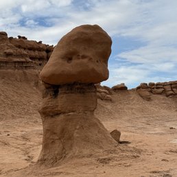
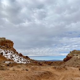
Goblin Valley State Park Photos


More like Goblin Valley State Park
Recommended Reviews - Goblin Valley State Park
Start your review...

Reviews With Photos
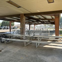
Beautiful state park with incredible topography with stunning hoodoos and rock formations. Super remote with little to no cell service. The park visitor center is very nice with wifi, firewood, ice and drinks. We stayed one night at the campground which was also fantastic. A beautiful location against a rock face, beautifully maintained with super clean bathrooms, showers, fire pits and sheltered gazebos. Special shoutout to Kevin Miller - campground host who we visited with over dinner. Kevin is a true steward of the park and its upkeep - loved our chat with him and his insights into the park and surrounding area. Bravo!

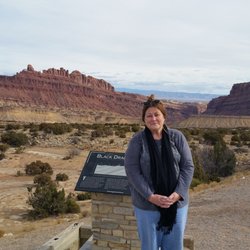
Goblin Valley State Park has such an inviting name. How can you not resist coming here to see what this place is all about? It's located in the southern part of Utah about 225 miles south of Salt Lake City. I spent the night in Green River, Utah, about 50 miles north and just drove here for the day. It's not far from Utah's "Mighty 5" national parks. It can fit into anyone's itinerary for a roadtrip. When thinking of Utah and the amazing diversity of landscapes it offers, I figured Goblin Valley would be a dream visit. There are these "goblin heads" dispersed throughout the park, which are another name for hoodoos. And if you've ever visited Bryce Canyon, those over there feature the penultimate hoodoos. Here at Goblin Valley, I wouldn't say they're a more watered down version of Bryce's hoodoos, they're just featured on a lesser grand scale. The backdrop isn't as dramatic, but in a way, it's so hard to compete with Bryce Canyon on any level. Bryce is one of the most beautiful national parks in the world. And so here at Goblin Valley, it's more of a local type of park, where you can explore and get up close to goblin heads in a choose your own adventure pathway. Let me explain... When arriving, you drive maybe two miles towards a dead end parking lot. There are 50 or so spaces for cars. So right then and there, Goblin Valley doesn't get many visitors. It's under the radar. But at this parking lot, you leave your car and then walk down a staircase onto the valley floor where it's walk wherever you'd like and pick how you'd like to approach these goblin heads. You can continue throughout the valley and let your imagination run wild for as long as you can stand the heat. And I mention this because during summertimes when the sun is shining brightly, it will get hot. And there's zero shade anywhere. I stopped by at the end of September and conditions were very manageable, around the low 80 degrees. But I did carry water with me and when I returned to the parking lot after a few hours, I was still thirsty. I researched that there are 3 Valley Sections to the park. And once you climb down the initial stairs, you'll notice a sign saying "Valley 1". If you maintain hiking towards the right hand side and continue further away from the parking lot, you'll experience "Valley 2" which felt like a tighter clustering of goblin heads compared to the sparse Valley 1. Btw...I couldn't locate the exact sign for Valley 2. I just assumed I was standing in it based on assumptions from what I researched ahead of time. After walking around for a few hours, I wouldn't say I got lost, but I couldn't even locate "Valley 3". Maybe I should have brought the park map with me while hiking, lol. But...after being among Valley 2, I felt like I had a better understanding of what this place was all about. I was okay with returning to the parking lot. And don't fear about getting lost. The parking lot is viewable from almost anywhere throughout the valley (for the most part). More to do.... - Three Sisters Column - short walk to an iconic part of Goblin Valley featuring "3 Sisters" heads aligned on top of a sandstone formation. Good for a picture. It's located on the drive towards the parking lot. - Carmel Canyon Loop - 1.5 mile loop which is located at the opposite end of the parking lot away from the Valley Floor. The hike starts out with views of goblin heads from high above before entering down to the floor leading to Goblin's Lair. I read Goblin's Lair is a dimly lit slot canyon that requires scrambling and repelling. You may need a permit at the Visitor Center for it. They suggest experienced canyoneers attempt it. I opted to continue along Carmel Canyon Loop which twisted its way through its own slot canyon adding an adventurous element to the hike. Other short hikes at the park (but I didn't hike them)... - Entrada Canyon - 1.5 miles each way - Curtis Bench Trail - 1.5 miles each way too In my opinion, none of these hikes will match being at the Valley Floor for closeup views of the goblin heads. Extra notes... - You can climb on the goblins, but it's discouraged against because of the slippery nature of them leading to possibly falling. - It's $20 entrance fee. Unfortunately they don't accept National Park Yearly Passes. Goblin Valley is a separate state park. - The Welcome to Goblin Valley Sign sits 6 miles before the entrance gate. You can stop for a picture there. Then, at the entrance gate is the Visitor Center. You can enter the VC for souvenirs, restrooms and stamping your Parks Passport. - There's a campground here. There's barely any cell reception. The parking lot beside the Valley Floor has an awning with tables and benches overlooking the surroundings. In the end, Goblin Valley was a much more low key kind of state park visit. Since it doesn't get the awareness compared to its national park neighbors, it can be suitable for those folks trying to steer clear of the crowds.

Goblin Valley State Park is a hidden gem amongst over six million acres of spectacular canyon country wilderness that surrounds the park. There are endless exploration opportunities for those that take a little time to research these lesser explored areas. Be sure to check out the Goblin's Lair Canyoneering Adventure at the park. One of the most unique and exciting experiences in Southern Utah. https://getinthewild.com/adventure/half-day-goblins-lair-canyoneering-adventure/

Very unique formations. It's like stepping onto another planet! It was the middle of June and very very hot at Goblin Valley. We were appreciative of the shade structure with picnic tables overlooking the valley. It was a short walk down to the structures to explore. There were clean flushing toilets on site at the parking lot.


This state park is about 1.5 hours from Moab, and so worth it to venture out here. I did arches, canyonlands, all the typical activities, but Goblin Valley ended up being a highlight of my trip! The fee is $25 for a car and it's a short drive from the little visitors center to valley of the goblins. There's a little hike you can do behind the toilets that is just magnificent. Only about 2 miles, but such a unique experience. There's desert sand all over and in some parts you're walking on it! Beautiful rock formations everywhere and as you make your way in, you're surrounded by these big goblin looking rocks! You can climb on them, walk all around them, picnic, whatever you want. It was just breathtaking and unlike anywhere I've ever been before. If you're in the area, this is an experience you won't want to miss.

Southern Utah is such a beautiful place filled with National Parks and inserted in between are just as awe inspiring state parks. Goblin Valley State Park is one of those. This was a great stop and I enjoyed my visit so very much! It's a $20 entrance fee and then you can proceed to the Three Sisters rock formations and then the Goblin Valley areas. There are three Valleys where the main parking lot is. I am not sure how many I made it to but I went out quite a ways. Such beautiful formations and I can see why they may call some of them "Goblins". The lairs are really cool over by some cliffs and it was so much fun "getting lost" in the environment here. Wildlife I spotted were adorable little lizards skittering along the ground. Definitely bring water. I live in low elevations and I am not used to desert heat anymore and gave myself a hot flash. There are nearby slot canyons to explore but I believe those are on a gravel road and didn't really want to take my little car on there especially since I was recovering from being overheated. Definitely an awesome place to visit but I cannot emphasize enough to bring water and sun block even if it is early Autumn.

Goblin Valley State Park is nothing short of spectacular! It's hard to describe the unique landscape without saying otherworldly. Wandering through the Goblin's Garden is as close to visiting another planet as any of us will experience. Our kids loved exploring the goblin or hoodoo formations. For the more adventurous and prepared, rappelling into the Goblin's Lair is an incredible experience! The 90-foot free-hanging rappel takes you into an enormous underground cavern that's spectacular. You can also access the Goblin's Lair on foot, and it's only a short hike. But rappelling is a lot more fun! Whether you're just passing through or camping nearby for a few days, exploring Goblin Valley is worth your time. It's a great Utah State Park and well managed by the friendly staff.


Goblin Valley might pale in comparison to other state parks, but it can still stand on its own as an excellent spot of nature's beauty. I mean, you can walk amongst hoodoos for goodness sake! The reasons one might find disappointment at Goblin Valley are as follows: It is small, there is limited hiking, and the appearance is quite barren, however these are also reasons to love it! When I visited, I saw maybe 15 other cars, and granted, it was in late January, but still! To go to a state park and encounter so few fellow visitors is a dream. If you are seeking hiking only, a stop at Goblin Valley is still worth your time (you MUST do Goblin's Lair, more on that below), but just add Little Wild Horse Canyon Trail, located a few miles outside the park, to your to-do list and you should be satisfied. And not everyone wants to hike anyways. A drive through GV is quick and easy, and if you are simply seeking relaxation amongst nature. you can just park at various spots and explore the hoodoos at your leisure. Lastly, while you may not see many trees or large bushes, you will instead find scrubby plant specimens and wildflowers that add a surprising amount of green and contrast to the otherworldly beauty of the sandy multicolored rock formations. Now, Goblin's Lair is a short out and back hike of 2 1/2 miles. The trailhead is located at the observation point, right next to the restrooms. It is easy peasy with almost no elevation gain, however actually getting inside the lair requires some rock scrambling. Totally doable, though! The entrance just looks like a pile of rocks from the trail, belying what awaits. As we hiked up and finally looked into the dark interior....whew, it truly gave me chills. A little creepy at first, then once my eyes adjusted to the light, and we climbed down inside, it is breathtaking. The space is over 100 feet tall, and with no one else about, it felt like I was on another planet or in some story where a dragon might appear at any moment. Without solitude, the experience would not feel quite so magical, so I recommend making an effort to hike it at off-times; though make your way here no matter what. Park entrance fee is $15, and worth it for the experience of Goblin's Lair alone. Camping is available ($30 fee) within the park, but only in designated spots (you will see loads of visitors sidle their RVs next to rock walls outside the park, though). They even have two yurts! Sadly, those book out months in advance, but are worth researching. GV is dark sky certified, meaning you will see the most glorious display of glittering stars. Seriously, you can admire the Milky Way with your own unassisted eyes! If you opt not to camp, the closest city in which to spend the night is Hanksville, offering a few questionable motels and like two restaurants (none open in the off season). I would travel an hour west into Torrey for superior lodging.

Talk about solitude. Visited right after the Thanksgiving day and place was empty, void of crowd. Ran into 3 couples. I kept hearing very low key, rarely visited state park. Perfect place to hike, check out different formation and enjoy the nature. Didn't get a chance to check out the camp sites but did see yute on the way out, situated just below to bluff. Clean bathroom at the ranger station with friendly employee and about 5 miles to the Little Wild Horse Canyon to check out the slot canyon.

We took this as a side trip and we really should have given this more time. If you are thinking of coming here, I recommend looking at all the activities offered to see how much is here to do so you won't feel as though you missed out on some of what makes this park FUN! As for us, we ran around the valley, played hide and seek, marveled at how these "goblins" were made and just had a great adventure with the time we had. read more

4 months ago
1 month ago
Beautiful state park with incredible topography with stunning hoodoos and rock formations. Super remote with little to no cell service. The park visitor center is very nice with wifi, firewood, ice and drinks. We stayed one night at the campground which was also fantastic. A beautiful location against a rock face, beautifully maintained with super clean bathrooms, showers, fire pits and sheltered gazebos. Special shoutout to Kevin Miller - campground host who we visited with over dinner. Kevin is a true steward of the park and its upkeep - loved our chat with him and his insights into the park and surrounding area. Bravo! read more


9 months ago
Goblin Valley State Park has such an inviting name. How can you not resist coming here to see what this place is all about? It's located in the southern part of Utah about 225 miles south of Salt Lake City. I spent the night in Green River, Utah, about 50 miles north and just drove here for the day. It's not far from Utah's "Mighty 5" national parks. It can fit into anyone's itinerary for a roadtrip. When thinking of Utah and the amazing diversity of landscapes it offers, I figured Goblin Valley would be a dream visit. There are these "goblin heads" dispersed throughout the park, which are another name for hoodoos. And if you've ever visited Bryce Canyon, those over there feature the penultimate hoodoos. Here at Goblin Valley, I wouldn't say they're a more watered down version of Bryce's hoodoos, they're just featured on a lesser grand scale. The backdrop isn't as dramatic, but in a way, it's so hard to compete with Bryce Canyon on any level. Bryce is one of the most beautiful national parks in the world. And so here at Goblin Valley, it's more of a local type of park, where you can explore and get up close to goblin heads in a choose your own adventure pathway. Let me explain... When arriving, you drive maybe two miles towards a dead end parking lot. There are 50 or so spaces for cars. So right then and there, Goblin Valley doesn't get many visitors. It's under the radar. But at this parking lot, you leave your car and then walk down a staircase onto the valley floor where it's walk wherever you'd like and pick how you'd like to approach these goblin heads. You can continue throughout the valley and let your imagination run wild for as long as you can stand the heat. And I mention this because during summertimes when the sun is shining brightly, it will get hot. And there's zero shade anywhere. I stopped by at the end of September and conditions were very manageable, around the low 80 degrees. But I did carry water with me and when I returned to the parking lot after a few hours, I was still thirsty. I researched that there are 3 Valley Sections to the park. And once you climb down the initial stairs, you'll notice a sign saying "Valley 1". If you maintain hiking towards the right hand side and continue further away from the parking lot, you'll experience "Valley 2" which felt like a tighter clustering of goblin heads compared to the sparse Valley 1. Btw...I couldn't locate the exact sign for Valley 2. I just assumed I was standing in it based on assumptions from what I researched ahead of time. After walking around for a few hours, I wouldn't say I got lost, but I couldn't even locate "Valley 3". Maybe I should have brought the park map with me while hiking, lol. But...after being among Valley 2, I felt like I had a better understanding of what this place was all about. I was okay with returning to the parking lot. And don't fear about getting lost. The parking lot is viewable from almost anywhere throughout the valley (for the most part). More to do.... - Three Sisters Column - short walk to an iconic part of Goblin Valley featuring "3 Sisters" heads aligned on top of a sandstone formation. Good for a picture. It's located on the drive towards the parking lot. - Carmel Canyon Loop - 1.5 mile loop which is located at the opposite end of the parking lot away from the Valley Floor. The hike starts out with views of goblin heads from high above before entering down to the floor leading to Goblin's Lair. I read Goblin's Lair is a dimly lit slot canyon that requires scrambling and repelling. You may need a permit at the Visitor Center for it. They suggest experienced canyoneers attempt it. I opted to continue along Carmel Canyon Loop which twisted its way through its own slot canyon adding an adventurous element to the hike. Other short hikes at the park (but I didn't hike them)... - Entrada Canyon - 1.5 miles each way - Curtis Bench Trail - 1.5 miles each way too In my opinion, none of these hikes will match being at the Valley Floor for closeup views of the goblin heads. Extra notes... - You can climb on the goblins, but it's discouraged against because of the slippery nature of them leading to possibly falling. - It's $20 entrance fee. Unfortunately they don't accept National Park Yearly Passes. Goblin Valley is a separate state park. - The Welcome to Goblin Valley Sign sits 6 miles before the entrance gate. You can stop for a picture there. Then, at the entrance gate is the Visitor Center. You can enter the VC for souvenirs, restrooms and stamping your Parks Passport. - There's a campground here. There's barely any cell reception. The parking lot beside the Valley Floor has an awning with tables and benches overlooking the surroundings. In the end, Goblin Valley was a much more low key kind of state park visit. Since it doesn't get the awareness compared to its national park neighbors, it can be suitable for those folks trying to steer clear of the crowds. read more


 which offers good photo opportunities. - Parks Near Me - Green River, Utah")


10 months ago
Goblin Valley State Park is a hidden gem amongst over six million acres of spectacular canyon country wilderness that surrounds the park. There are endless exploration opportunities for those that take a little time to research these lesser explored areas. Be sure to check out the Goblin's Lair Canyoneering Adventure at the park. One of the most unique and exciting experiences in Southern Utah. https://getinthewild.com/adventure/half-day-goblins-lair-canyoneering-adventure/ read more


Very unique formations. It's like stepping onto another planet! It was the middle of June and very very hot at Goblin Valley. We were appreciative of the shade structure with picnic tables overlooking the valley. It was a short walk down to the structures to explore. There were clean flushing toilets on site at the parking lot. read more


1 year ago
20 dollars to enter park but the pass lasts a full 24 hours. It was without a doubt one of the coolest Utah cities experiences I've had and I'm a tried and true local. Will be coming back to explore the endless areas. read more


3 years ago
This state park is about 1.5 hours from Moab, and so worth it to venture out here. I did arches, canyonlands, all the typical activities, but Goblin Valley ended up being a highlight of my trip! The fee is $25 for a car and it's a short drive from the little visitors center to valley of the goblins. There's a little hike you can do behind the toilets that is just magnificent. Only about 2 miles, but such a unique experience. There's desert sand all over and in some parts you're walking on it! Beautiful rock formations everywhere and as you make your way in, you're surrounded by these big goblin looking rocks! You can climb on them, walk all around them, picnic, whatever you want. It was just breathtaking and unlike anywhere I've ever been before. If you're in the area, this is an experience you won't want to miss. read more


Southern Utah is such a beautiful place filled with National Parks and inserted in between are just as awe inspiring state parks. Goblin Valley State Park is one of those. This was a great stop and I enjoyed my visit so very much! It's a $20 entrance fee and then you can proceed to the Three Sisters rock formations and then the Goblin Valley areas. There are three Valleys where the main parking lot is. I am not sure how many I made it to but I went out quite a ways. Such beautiful formations and I can see why they may call some of them "Goblins". The lairs are really cool over by some cliffs and it was so much fun "getting lost" in the environment here. Wildlife I spotted were adorable little lizards skittering along the ground. Definitely bring water. I live in low elevations and I am not used to desert heat anymore and gave myself a hot flash. There are nearby slot canyons to explore but I believe those are on a gravel road and didn't really want to take my little car on there especially since I was recovering from being overheated. Definitely an awesome place to visit but I cannot emphasize enough to bring water and sun block even if it is early Autumn. read more


Goblin Valley State Park is nothing short of spectacular! It's hard to describe the unique landscape without saying otherworldly. Wandering through the Goblin's Garden is as close to visiting another planet as any of us will experience. Our kids loved exploring the goblin or hoodoo formations. For the more adventurous and prepared, rappelling into the Goblin's Lair is an incredible experience! The 90-foot free-hanging rappel takes you into an enormous underground cavern that's spectacular. You can also access the Goblin's Lair on foot, and it's only a short hike. But rappelling is a lot more fun! Whether you're just passing through or camping nearby for a few days, exploring Goblin Valley is worth your time. It's a great Utah State Park and well managed by the friendly staff. read more


It's out of this world amazing. The rock formations are unique and looks like.. well use your imagination. I didn't make it to one of the trails because it was getting dark, but I can't wait to come back one day. Highly recommend this place. Stay for sunset!! And bring tons of water. read more


3 years ago
3 years ago
We had a blast getting lost in the valley. Bring plenty of water and remember where you are in relation to the parking lot. We went on a Friday afternoon and we only saw one other group the entire 4 hours we explored goblin valley. read more


Goblin Valley might pale in comparison to other state parks, but it can still stand on its own as an excellent spot of nature's beauty. I mean, you can walk amongst hoodoos for goodness sake! The reasons one might find disappointment at Goblin Valley are as follows: It is small, there is limited hiking, and the appearance is quite barren, however these are also reasons to love it! When I visited, I saw maybe 15 other cars, and granted, it was in late January, but still! To go to a state park and encounter so few fellow visitors is a dream. If you are seeking hiking only, a stop at Goblin Valley is still worth your time (you MUST do Goblin's Lair, more on that below), but just add Little Wild Horse Canyon Trail, located a few miles outside the park, to your to-do list and you should be satisfied. And not everyone wants to hike anyways. A drive through GV is quick and easy, and if you are simply seeking relaxation amongst nature. you can just park at various spots and explore the hoodoos at your leisure. Lastly, while you may not see many trees or large bushes, you will instead find scrubby plant specimens and wildflowers that add a surprising amount of green and contrast to the otherworldly beauty of the sandy multicolored rock formations. Now, Goblin's Lair is a short out and back hike of 2 1/2 miles. The trailhead is located at the observation point, right next to the restrooms. It is easy peasy with almost no elevation gain, however actually getting inside the lair requires some rock scrambling. Totally doable, though! The entrance just looks like a pile of rocks from the trail, belying what awaits. As we hiked up and finally looked into the dark interior....whew, it truly gave me chills. A little creepy at first, then once my eyes adjusted to the light, and we climbed down inside, it is breathtaking. The space is over 100 feet tall, and with no one else about, it felt like I was on another planet or in some story where a dragon might appear at any moment. Without solitude, the experience would not feel quite so magical, so I recommend making an effort to hike it at off-times; though make your way here no matter what. Park entrance fee is $15, and worth it for the experience of Goblin's Lair alone. Camping is available ($30 fee) within the park, but only in designated spots (you will see loads of visitors sidle their RVs next to rock walls outside the park, though). They even have two yurts! Sadly, those book out months in advance, but are worth researching. GV is dark sky certified, meaning you will see the most glorious display of glittering stars. Seriously, you can admire the Milky Way with your own unassisted eyes! If you opt not to camp, the closest city in which to spend the night is Hanksville, offering a few questionable motels and like two restaurants (none open in the off season). I would travel an hour west into Torrey for superior lodging. read more


8 years ago
Talk about solitude. Visited right after the Thanksgiving day and place was empty, void of crowd. Ran into 3 couples. I kept hearing very low key, rarely visited state park. Perfect place to hike, check out different formation and enjoy the nature. Didn't get a chance to check out the camp sites but did see yute on the way out, situated just below to bluff. Clean bathroom at the ranger station with friendly employee and about 5 miles to the Little Wild Horse Canyon to check out the slot canyon. read more


6 years ago
Ok this place is SEVERELY underrated. I visited Goblin Valley as a part of my trip to see the Mighty 5 national parks in Utah in late November. I loved Goblin Valley, I thought it was so cool to see Goblin Lair, Goblette Lair, and the hoodoos. Even in November, I faced temperatures in the mid 50s so it was pleasantly warm. Definitely a must visit place full of mystery and exploration! read more


5 years ago
The red planet of goblins A magical wonderland, For curiouser, seeker, dreamer, adventurer Explorer and story teller We are all children With our imaginations Playing hide and seek In this red village Under the majestic temple Hiding from reality Yet seeking for truth read more


6 years ago
Whoaaa! Quick little stop between Capitol Reef and canyonland! Glad we made the detour. Kids had a blast Climbing the hoodoos. read more


6 years ago
This place was rad!!! Everyone says it, but it feels like Mars!! Totally does. The parking lot was 3/4 full, but we didn't feel it was packed when we went on the trails. Spent a few hours here and absolutely loved it!!? read more


The mailing address of this state park may be Green River, but it's actually located about 12 miles north of Hanksville, Utah, on Route 24. Although the road is well-paved and the park itself has a well-groomed parking lot and comfortable campground, this place is in the middle of nowhere. Goblin Valley once had the name of Mushroom Valley and both names are apt. The Entrada sandstone rock formations resemble giant mushrooms or goblins and the sunsets here almost make these creatures come alive. There's no strenuous hiking here, just a fun romp through an almost silly landscape. If you're anywhere in the area, this state park is worth the detour. read more


8 years ago
If you're coming to Utah to explore National/state parks, this one is a MUST...Especially if you have kids! Goblins lair is a must, the kids loved running and climbing through all the hoodoos. Around each corner there is a new, cool place to explore. My kids have said to me countless of times since we have visited that this is their favorite Utah state park we have visited so far on our road trip. read more


9 years ago
5 years ago
Such an incredible spot. We stayed 1 night in one of the 2 yurts on site. If you can, plan your trip around a new moon and being a desert there are few clouds most days. Come bring your blanket and spend hours star gazing. Considered one of the darkest places on earth you can easily see the Milky Way and will spot tons of shooting stars. This is a great one night stop. read more

4 years ago


Goblin Valley State Park is a cute little side destination which you should see if you are in the area visiting the major parks (Arches & Canyonlands) and/or are taking the scenic route (http://www.yelp.com/biz/utah-scenic-byway-12-tropic#hrid:4f4LKagO0e5YdTwC9icsig ) on the way from Arches to Capitol Reef and Bryce Canyon. The drive to the park is scenic in itself with several immense buttes along the way. Goblin Valley is an unusual collection of hoodoos (rock formations formed by wind erosion as opposed to water erosion) which tend to be "top heavy" and therefore look like a series of busts or mushrooms. Some look animated yet in a misshapen way, i.e. Goblin-like! We were there in winter when each formation had a sprinkling of snow, so that from a distance the valley resembled sheets of gingerbread muffins coated with frosting (see my photos)! Close up, we had fun playing "guess that shape" with the formations and identified Hello Kitty, Richard Nixon, and the Sphinx. My dog lifted his rear leg in salute to Tricky Dick. While this park is probably more for kids (and those of us who are still kids at heart) than serious outdoors-types, fun, photo-ops, rock climbing, and a decent hike can be had by all who come here. There are also nearby trails including one through a slot canyon. Sadly we did not have time to check these out. Definitely worth the trip! BTW, Goblin Valley is about 40 miles from Green River, not in the town as the address in Yelp implies. read more


Page 1 of 2
More info about Goblin Valley State Park
Ask the Community - Goblin Valley State Park
Review Highlights - Goblin Valley State Park


Why does Yelp recommend reviews?
1 review that is not currently recommended
The reviews below are not factored into the business's overall star rating.
2 years ago
Goblin Valley State Park - parks - Updated August 2026
Best of Green River
People found Goblin Valley State Park by searching for…
Things to Do in Green River, UT
Campgrounds in Green River, UT
Public Shower in Green River, UT
Water Parks in Green River, UT
Hot Springs in Green River, UT
Watch Sunset in Green River, UT
Places to Swim in Green River, UT
Attractions in Green River, UT
Playgrounds in Green River, UT
Dog Friendly Trails in Green River, UT
Visitor Centers in Green River, UT
Hiking Trails in Green River, UT
Places to Take Pictures in Green River, UT
Canyoneering in Green River, UT
Star Gazing in Green River, UT
Running Trails in Green River, UT
Scenic Overlook in Green River, UT
Trending Searches in Green River, UT
Boat Tours near Goblin Valley State Park
Cliff Jumping near Goblin Valley State Park
Kayak Rental near Goblin Valley State Park
Parks near Goblin Valley State Park
Playgrounds near Goblin Valley State Park
Public Shower near Goblin Valley State Park
Swimming Holes near Goblin Valley State Park
Swimming Lakes near Goblin Valley State Park
Browse Articles
Browse Nearby
Browse Brands
Related Searches in Green River, UT
Affordable Kayak Rental Services in Green River, Utah
Best Dog Hiking Trails Around Green River, Utah
Best Lookout Points to Visit in Green River, Utah
Best Nature Trails for Hiking in Green River, Utah
Best Places for Horseback Riding in Green River, Utah
Best Spots for Star Gazing in Green River, Utah
Best Water Parks for Kids in Green River, Utah
Best Waterfalls and Swimming Holes in Green River, Utah
Check Out Great Playgrounds in Green River, Utah
Check Out Off Road Trails in Green River, Utah
Discover Dog Friendly Trails to Explore in Green River, Utah
Discover Lakes & Ponds to Explore in Green River, Utah
Discover Popular Bike Trails in Green River, Utah
Discover Popular Photo Spots in Green River, Utah
Discover Scenic Mountain Bike Trails Near Green River, Utah
Discover Top Boat Tours in Green River, Utah for All Ages
Discover Top Nature Parks to Visit in Green River, Utah
Discover a Hiking Trail in Green River, Utah
Discover the Best Night Hike Trails in Green River, Utah
Dog-Friendly Hikes With Dogs in Green River, Utah
Enjoy Arts & Entertainment in Green River, Utah
Enjoy Exciting Mountain Biking Adventures in Green River, Utah
Enjoy Hiking Adventures in Green River, Utah
Enjoy Kayaking Adventures in Green River, Utah
Enjoy Off Leash Dog Hikes in Green River, Utah
Enjoy Scenic Night View Experiences in Green River, Utah
Enjoy Tent Camping Spots Around Green River, Utah
Enjoy the Best Night View Spots in Green River, Utah
Enjoy the Best Picnic Spots and Ideas in Green River, Utah
Enjoy the Best Tubing Experiences in Green River, Utah
Enjoy the Best Walking Trails in Green River, Utah
Experience Stunning Sunset Views in Green River, Utah
Explore Beautiful Parks and Green Spaces in Green River, Utah
Explore Bike Rentals Throughout Green River, Utah
Explore Easy Hikes Perfect for All in Green River, Utah
Explore Free Picnic Areas Around Green River, Utah
Explore Picnic Parks Near Green River, Utah
Explore Popular Campgrounds Near Green River, Utah
Explore Popular Picnic Areas Around Green River, Utah
Explore Popular RV Parks Around Green River, Utah
Explore Popular Scenic Overlook Points in Green River, Utah
Explore Popular Scenic Views Near Green River, Utah
Explore Popular View Points Around Green River, Utah
Explore Scenic Lakes to Visit in Green River, Utah
Explore Secret Spots Worth Visiting in Green River, Utah
Explore Top Gyms in Green River, Utah Now
Explore Venues & Event Spaces in Green River, Utah