Hickman Bridge Photos

 - Hiking Near Me - Fruita, Utah")


You might also consider
More like Hickman Bridge
Recommended Reviews - Hickman Bridge
Start your review...

Reviews With Photos - Hickman Bridge

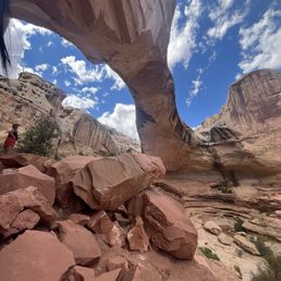
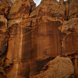
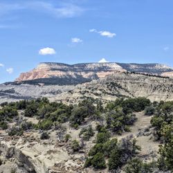
Hickman Bridge is a fantastic trail and was the highlight of our visit to Capital Reef National Park! The trail is very well maintained and well marked in most places and you'll be surrounded by some pretty awesome rock formations and geological wonders all along the hike that make Utah so special! AllTrails puts the trail at 1.7 miles long with 415+ feet elevation gain. But we did some exploring along some of the many offshoots and ended up doing about 2.5 miles with 500 feet elevation gain. The elevation gain is gradual and very doable so I'd call this trail moderate. Took us just under 2 hours but we were slow and goofing around a lot lol. Hickman Bridge is the main natural wonder along the trail - it's a huge natural bridge - one of the largest in the whole park - rising 125 feet tall and spanning 133 feet of dry wash bed. Definitely quite a sight to see and well worth the hike - I highly recommend it! The Hickman Bridge is definitely not the only wonder and fun feature along the trail. If you keep your eye out, you'll see a little area off to the right about halfway in that leads to a smaller natural bridge called Nels Johnson bridge and it's really cool! It's got two openings and it's still large enough for me to stand in and I'm 5'3" but my son had to slouch and he's almost 6' so watch your head if you're tall lol! Apparently there are also some granary ruins and petroglyphs along the trail, left by the ancient Fremont and Paiute peoples, but unfortunately we didn't find any of them and I wasn't aware until after - so keep an eye out for those too! After you leave the Hickman Bridge loop, just before returning to the main trail - keep an eye out for a little trail offshoot - it'll take you just over 1/4 of a mile and you'll be treated to some pretty incredible wide open vistas of a gorgeous, verdant valley with a river running through it - so beautiful!! The lovely Fremont River runs along the first part of the trail. All along the hike you'll be treated to really interesting and beautiful rock formations, plateaus, geological wonders, and wildlife - we saw tons of birds and even a Kangaroo Rat!! There's a parking lot at the trailhead, as well as street parking and some decent bathrooms. It's a popular trail deeper into the park that gets pretty crowded - but definitely worth it and the trail is wide enough to pass easily most of the way.

The hike to Hickman Bridge is not terribly long or strenuous so there's no reason for anyone to miss out on visiting the wondrous natural arch that has a span of 133 feet. The trail is less than 2 miles out and back. Since we visited Capitol Reef NP during the last week of October, fall vibes were in full effect so we were treated to gorgeous views of trees with leaves turning colors next to the Fremont River. The sound of the water coupled with the scenery was so peaceful, plus there were not a lot of people on the trail with us. The bridge itself is a wonder to behold; it's so big! Make sure you take your time viewing it from both sides. What a sight!

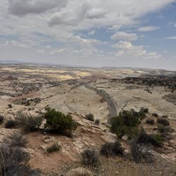
A relatively short but intense little jaunt out to the gorgeous natural Hickman Bridge! I hiked to Hickman Bridge right after tackling Cassidy Arch, so I was extremely tired by the time I completed the hike. But it proved to be worth the trek because Hickman Bridge is truly stunning. The hike itself is short; maybe about 2 miles total roundtrip. But what will get you is that quick 400+ feet of elevation gain and that heat. It. Gets. HAWT! So hot out there in the summer time! You should absolutely bring more water than you think that you'll need, and of course sunscreen and some kind of hat and/or sunglasses. Also, I'd recommend coming here when the weather is cooler. I was being a little too adventurous by starting this hike in the early evening in the dead of summer. And not only that; I did this right after hiking to Cassidy Arch which is a much more intense hike. Would highly recommend that you start this hike super early or later on in the day to avoid the heat. The hike begins by inclining up several switchbacks that consist of mostly stairs. You'll reach a trail split where you'll continue to the Hickman Bridge trail. The trail continues to incline through rocky terrain until you find yourself underneath the Hickman Bridge. It just creeps up on you like BOOM! But once you're there, it'll feel so surreal. The perspective is simply amazing. You'll literally be standing right underneath it. This is actually one of the only areas where you'll find shade, so it's the perfect place to take a break and relax while admiring the natural beaty of the bridge. After you pass up the natural bridge, you can continue on the trail until it loops you back down to the beginning. The views of the valley on the way back are something like a dream. You don't notice it as you're climbing up at the beginning of the trail, but you'll definitely be enamored by the views on your way back down. Because of the time of day that I went, I didn't run into too many people. This hike really isn't that hard, maybe moderate at best with the steady incline. But the heat and the prior hike that I had done really slowed me down, making it more difficult for me than usual. All in all, it's a great short hike with an amazing view of Hickman Bridge.

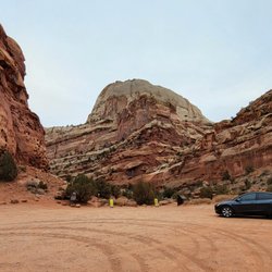
Came here with the 4th of July weekend & we got really lucky with parking. It was pretty packed & I've seen it where the cars are parked along the road & across the street. There is a bathroom in the parking lot & like I mentioned, there is limited parking. Probably fits about 10 cars in there. We hiked this in the afternoon & boy was it HOT. You start off coming up some stone stairs along the river then there is a bit of incline. The one thing to remember is that the whole trail to the bridge is NO SHADE. There's a small tree-like bush you can crouch under for a bit but it's pretty much open space. There are some easy parts as you can closer to the bridge. I would rate this easy-moderate. Be sure to bring water & apply sunscreen! There's A LOT of shade when you reach the bridge & the sight is pretty amazing. I would highly recommend this hike!

The parking lot is small, we had luck to find parking. Not as known as other NP, Capitol Reef NP is relatively unknown, there's 1.7 mile trial leading to the bridge, almost no cover. The trail is relatively easy, my record shows that elevation is about 400ft. The trail is clearly marked except at end of the loop merged with North Ridge Trail, I almost missed:)

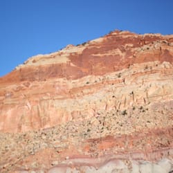
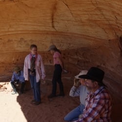
Now here's another delightful little hike in Capitol Reef National Park. We think about Arches NP as having all the arches and bridges -- and it's definitely the undisputed champion -- but there are a couple of fun arches and bridges here, and Hickman is one of them. The hiking guide you get at the main office lists this as "moderate" in difficulty with a distance of .9 miles, one way. Some hikes feel longer or shorter than their posted mileage, but this one is dead on. It's also probably fair to call it a moderately difficult hike, but in fairness I saw lots of families doing it with small kids. Also, in fairness, we had a panic moment on the trail when a French family lost one of their kids and it turned into a sprint shouting her name up and down the trail until they were reunited. There are some dropoffs to be had, so it's best to leave the littlest ones to other trails. Find the trailhead by going east on Highway 24 from the entrance of the park. It's less than two miles from there on the paved road, so you could even walk it from camp if you wanted to add a little more distance to things. Once at the trailhead, you'll take the Hickman Bridge trail, being careful to stay straight on it (as opposed to turning right/north) to get on the Rim Overlook/Navajo Knobs fork that you encounter about a quarter of a mile on the way in. From there, you make your way up a wash with some cool slab covered "caves" before getting on to more rocky areas. If you're looking for a fun little hike for the little ones, just stop here and they're none the wiser. Pressing on, you'll come to one last fork about 3/4 of a mile in, where they want you to go left. This fork actually forms a small loop that takes you around the rocks before peek-a-booing into the bottom of the bridge. Then you cross under the bridge and complete the loop, and head back out on the trail you ascended. Hickman Bridge itself is really nice. They list it at 133 feet long. While there, I made a note to research the difference between a bridge and an arch. I'm not a geologist, but the interwebs tell me that natural bridges are all natural arches, but not all arches are bridges. A bridge has the distinguishing characteristic of having its opening clearly formed by water, currently having water flow underneath it, currently being used as a bridge or means of road or transportation, or simply resembling a bridge with a curved arch underneath and flat top. Any one of those characteristics may be used to classify it as a bridge. Seems pretty wishy washy to me, so don't quote me at your next cocktail party without doing more due dilligence. Whether arch or bridge, it's a pretty cool sight and at only 1.8 miles round-trip, it's not much of a price to pay. It's kinda hard to photograph, as you've got canyon walls on both sides that keep you from backing up, so bring the widest angle lens you can. It may not be the flashiest of arches, but it's still a great little hike and an unexpected treat in Capitol Reef.

9 days ago
This is a lovely hike. It's not too steep, not very hard, and the bridge is pretty massive and beautiful when you reach it! It was recommended to me by friends and the volunteer at the visitor center because it's easy to do in a short time/on a short trip. There was plenty of trailhead parking as well. Would definitely recommend if you're passing through Capitol reef NP! read more


This is a mostly easy trail with some incline at the start. The path is clearly marked. Shade is minimal, so make sure you bring enough water and have sun protection. I always bring extra water bottles in addition to my hydration pack, and ended up giving two away to hikers who thought that because the trail was short, they'd only need one small bottle a person. Please do not underestimate Mother Nature. Even stopping for pictures and to cool down under the shade of the arch, the full loop took us about 90 minutes. But could be completed in under an hour if you're staying on the move. You're rewarded with a stunning natural arch for your efforts. The loop trail wraps behind the arch and there are plenty of pathways to climb about and explore. There are restrooms in the parking lot and you can wade in the river water to cool down pre or post hike. read more

8 months ago
What an awesome hike . Worth the hike to find this hidden treasure in Capitol Reef Park. Beautiful natural arch bridge. Quite big too. We highly recommend it. read more


Hickman Bridge is a fantastic trail and was the highlight of our visit to Capital Reef National Park! The trail is very well maintained and well marked in most places and you'll be surrounded by some pretty awesome rock formations and geological wonders all along the hike that make Utah so special! AllTrails puts the trail at 1.7 miles long with 415+ feet elevation gain. But we did some exploring along some of the many offshoots and ended up doing about 2.5 miles with 500 feet elevation gain. The elevation gain is gradual and very doable so I'd call this trail moderate. Took us just under 2 hours but we were slow and goofing around a lot lol. Hickman Bridge is the main natural wonder along the trail - it's a huge natural bridge - one of the largest in the whole park - rising 125 feet tall and spanning 133 feet of dry wash bed. Definitely quite a sight to see and well worth the hike - I highly recommend it! The Hickman Bridge is definitely not the only wonder and fun feature along the trail. If you keep your eye out, you'll see a little area off to the right about halfway in that leads to a smaller natural bridge called Nels Johnson bridge and it's really cool! It's got two openings and it's still large enough for me to stand in and I'm 5'3" but my son had to slouch and he's almost 6' so watch your head if you're tall lol! Apparently there are also some granary ruins and petroglyphs along the trail, left by the ancient Fremont and Paiute peoples, but unfortunately we didn't find any of them and I wasn't aware until after - so keep an eye out for those too! After you leave the Hickman Bridge loop, just before returning to the main trail - keep an eye out for a little trail offshoot - it'll take you just over 1/4 of a mile and you'll be treated to some pretty incredible wide open vistas of a gorgeous, verdant valley with a river running through it - so beautiful!! The lovely Fremont River runs along the first part of the trail. All along the hike you'll be treated to really interesting and beautiful rock formations, plateaus, geological wonders, and wildlife - we saw tons of birds and even a Kangaroo Rat!! There's a parking lot at the trailhead, as well as street parking and some decent bathrooms. It's a popular trail deeper into the park that gets pretty crowded - but definitely worth it and the trail is wide enough to pass easily most of the way. read more


The hike to Hickman Bridge is not terribly long or strenuous so there's no reason for anyone to miss out on visiting the wondrous natural arch that has a span of 133 feet. The trail is less than 2 miles out and back. Since we visited Capitol Reef NP during the last week of October, fall vibes were in full effect so we were treated to gorgeous views of trees with leaves turning colors next to the Fremont River. The sound of the water coupled with the scenery was so peaceful, plus there were not a lot of people on the trail with us. The bridge itself is a wonder to behold; it's so big! Make sure you take your time viewing it from both sides. What a sight! read more


A relatively short but intense little jaunt out to the gorgeous natural Hickman Bridge! I hiked to Hickman Bridge right after tackling Cassidy Arch, so I was extremely tired by the time I completed the hike. But it proved to be worth the trek because Hickman Bridge is truly stunning. The hike itself is short; maybe about 2 miles total roundtrip. But what will get you is that quick 400+ feet of elevation gain and that heat. It. Gets. HAWT! So hot out there in the summer time! You should absolutely bring more water than you think that you'll need, and of course sunscreen and some kind of hat and/or sunglasses. Also, I'd recommend coming here when the weather is cooler. I was being a little too adventurous by starting this hike in the early evening in the dead of summer. And not only that; I did this right after hiking to Cassidy Arch which is a much more intense hike. Would highly recommend that you start this hike super early or later on in the day to avoid the heat. The hike begins by inclining up several switchbacks that consist of mostly stairs. You'll reach a trail split where you'll continue to the Hickman Bridge trail. The trail continues to incline through rocky terrain until you find yourself underneath the Hickman Bridge. It just creeps up on you like BOOM! But once you're there, it'll feel so surreal. The perspective is simply amazing. You'll literally be standing right underneath it. This is actually one of the only areas where you'll find shade, so it's the perfect place to take a break and relax while admiring the natural beaty of the bridge. After you pass up the natural bridge, you can continue on the trail until it loops you back down to the beginning. The views of the valley on the way back are something like a dream. You don't notice it as you're climbing up at the beginning of the trail, but you'll definitely be enamored by the views on your way back down. Because of the time of day that I went, I didn't run into too many people. This hike really isn't that hard, maybe moderate at best with the steady incline. But the heat and the prior hike that I had done really slowed me down, making it more difficult for me than usual. All in all, it's a great short hike with an amazing view of Hickman Bridge. read more


5 years ago
Came here with the 4th of July weekend & we got really lucky with parking. It was pretty packed & I've seen it where the cars are parked along the road & across the street. There is a bathroom in the parking lot & like I mentioned, there is limited parking. Probably fits about 10 cars in there. We hiked this in the afternoon & boy was it HOT. You start off coming up some stone stairs along the river then there is a bit of incline. The one thing to remember is that the whole trail to the bridge is NO SHADE. There's a small tree-like bush you can crouch under for a bit but it's pretty much open space. There are some easy parts as you can closer to the bridge. I would rate this easy-moderate. Be sure to bring water & apply sunscreen! There's A LOT of shade when you reach the bridge & the sight is pretty amazing. I would highly recommend this hike! read more


 - Hiking Near Me - Fruita, Utah")


The parking lot is small, we had luck to find parking. Not as known as other NP, Capitol Reef NP is relatively unknown, there's 1.7 mile trial leading to the bridge, almost no cover. The trail is relatively easy, my record shows that elevation is about 400ft. The trail is clearly marked except at end of the loop merged with North Ridge Trail, I almost missed:) read more


10 years ago
Now here's another delightful little hike in Capitol Reef National Park. We think about Arches NP as having all the arches and bridges -- and it's definitely the undisputed champion -- but there are a couple of fun arches and bridges here, and Hickman is one of them. The hiking guide you get at the main office lists this as "moderate" in difficulty with a distance of .9 miles, one way. Some hikes feel longer or shorter than their posted mileage, but this one is dead on. It's also probably fair to call it a moderately difficult hike, but in fairness I saw lots of families doing it with small kids. Also, in fairness, we had a panic moment on the trail when a French family lost one of their kids and it turned into a sprint shouting her name up and down the trail until they were reunited. There are some dropoffs to be had, so it's best to leave the littlest ones to other trails. Find the trailhead by going east on Highway 24 from the entrance of the park. It's less than two miles from there on the paved road, so you could even walk it from camp if you wanted to add a little more distance to things. Once at the trailhead, you'll take the Hickman Bridge trail, being careful to stay straight on it (as opposed to turning right/north) to get on the Rim Overlook/Navajo Knobs fork that you encounter about a quarter of a mile on the way in. From there, you make your way up a wash with some cool slab covered "caves" before getting on to more rocky areas. If you're looking for a fun little hike for the little ones, just stop here and they're none the wiser. Pressing on, you'll come to one last fork about 3/4 of a mile in, where they want you to go left. This fork actually forms a small loop that takes you around the rocks before peek-a-booing into the bottom of the bridge. Then you cross under the bridge and complete the loop, and head back out on the trail you ascended. Hickman Bridge itself is really nice. They list it at 133 feet long. While there, I made a note to research the difference between a bridge and an arch. I'm not a geologist, but the interwebs tell me that natural bridges are all natural arches, but not all arches are bridges. A bridge has the distinguishing characteristic of having its opening clearly formed by water, currently having water flow underneath it, currently being used as a bridge or means of road or transportation, or simply resembling a bridge with a curved arch underneath and flat top. Any one of those characteristics may be used to classify it as a bridge. Seems pretty wishy washy to me, so don't quote me at your next cocktail party without doing more due dilligence. Whether arch or bridge, it's a pretty cool sight and at only 1.8 miles round-trip, it's not much of a price to pay. It's kinda hard to photograph, as you've got canyon walls on both sides that keep you from backing up, so bring the widest angle lens you can. It may not be the flashiest of arches, but it's still a great little hike and an unexpected treat in Capitol Reef. read more


10 years ago
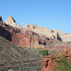
A very nice, moderately difficult hike (approximately 2 miles round trip) through the white Capitol-dome like structures that give Capitol Reef it's name. The trail has some steep portions, but nothing huge. Hickman Bridge is at the end of the hike, and there's a nice loop around it so you can see it from both sides. I especially liked seeing the river you walk briefly by, and was able to see quite a bit of wildlife enjoying the water! read more


10 years ago
More info about Hickman Bridge
Ask the Community - Hickman Bridge
Review Highlights - Hickman Bridge


Hickman Bridge - hiking - Updated July 2026
Best of Fruita
People found Hickman Bridge by searching for…
Browse Nearby
BEST of Fruita, Utah Parks near Hickman Bridge
BEST of Fruita, Utah Things to Do near Hickman Bridge
BEST of Fruita, Utah Coffee near Hickman Bridge
BEST of Fruita, Utah Horseback Riding near Hickman Bridge
BEST of Fruita, Utah Restaurants near Hickman Bridge