Calf Creek Falls Lower Photos


You might also consider
More like Calf Creek Falls Lower
Recommended Reviews - Calf Creek Falls Lower
Start your review...

Reviews With Photos

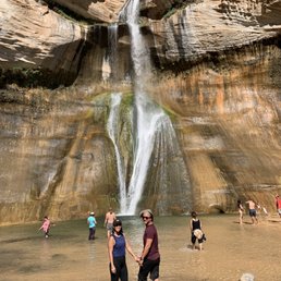
I absolutely loved this hike! My husband and I completed the 6-mile out-and-back trek on a cool October morning without a lot of people on the trail. The 126-foot waterfall is beautiful and we desert folk are so appreciative that we got to see it since Vegas does not offer any falls like these. The trail is not too strenuous; for the most part it's flat with a few spots where you have to maneuver up over some rocks. You'll encounter beautiful trees which are currently showing off their fall colors. You'll hear the peaceful sound of the water from the creek. When you get to the waterfall, you can sit on a log and just admire its beauty. Be sure to take advantage of the clean restrooms at the parking lot before you set out as there are no facilities on the trail. Pack out what you pack in. Leave no trace except the smiles on your face--happy trails!

From the trailhead to the falls and back measured out to be 6.3 miles with 200 feet of elevation gain and loss. My son, his wife, and I took three hours to do this hike, including stopping to look at the well-marked petroglyphs, granary, beaver pond, and waterfall, marveling at the spectacular falls, creek and canyon, plus time to chat with other hikers and their dogs. We were advised to arrive early. We got to the trailhead by 8:30 on a cool April Wednesday morning. There was plenty of parking at that hour, but the trailhead lot was full to overflowing by our 11:30 a.m. return, with cars, SUVs, campers, and other vehicles jockeying for spots in the lot, along the driveway, and out on the road. BLM charges $5 for a parking tag, cash only. Lots of folks had dogs, some delightful, others not so much. As an out-and-back hike, this trail is great for anyone with a decent balance (there's some slight rock climbing, none requiring hands and knees). Short stretches of the trail are narrow, but none without "pull-outs" within short range. Do the whole thing, or turn around if and when you start to feel uncomfortable The pool and waterfall are spectacular. We easily spent 15-20 minutes just taking in the view. We did find a *big* mountain lion track near the waterfall (yes, I know the difference between a dog print and a mountain lion print).
Absolutely fell in love with this place. It costs $5 to get in and there is ample parking. It is roughly a 6 mile hike round trip. There is fine sand everywhere on the trail so it will definitely give you a work out but at least it's easy on the joints. I recommend going early in the summer months because it gets very hot and sunny. Take plenty of water! I took 2 liters and drank most of it. I saw many people bring their dogs and I felt bad for the poor doggos as I'm sure the sand was burning the soles of their paws. Be smart and put shoes on your dog, people! Good thing there is plenty of water from the creek to cool off and some shade. The waterfall is magnificent. It's such a nice place to chill, cool down and take pictures. There is also overnight camping which I'm definitely interested in. I will definitely be back!

Beautiful 6 mile out and back dog friendly hike. Some climbing over boulders but easily could be done with kids. Beautiful waterfall at the end. We camped and then walked over to the hike from our spot. Awesome campgrounds with the creek flowing right by the spots. Firepits with grill attachments at each spot as well as a firepit and separate grill out front by the parking for public day use. Things to note No phone service in the area Heavily trafficked Bring lots of water as there isn't much shade during the hike Lots of cacti off the trail so watch your dogs and kids
Beautiful waterfall in the Grand Staircase - Escalante. I visited here on my way from Capitol Reef to Bryce Canyon in late November. It was cold but you feel incredibly warm in the patches of sunlight during this time. I had the whole trail to myself and had a beautiful view of the waterfall at the end. It was a 6 mile round trip hike and took a couple hours. It's relatively flat so not too difficult at all. Regardless of the weather, you have to take a dip in the water at the end!

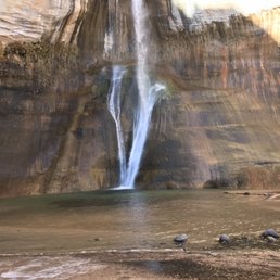
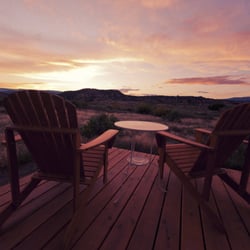
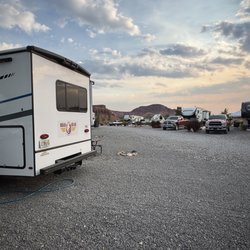
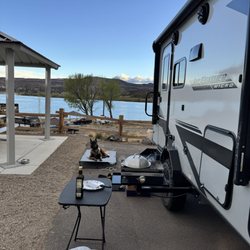
Our (my wife and I) extended labor day journey started here at Calf Creek Campground recreation area. Daily parking is $5 and overnight camping is $15 per car. There are limited parking spaces, about 10 and camping sites, maybe 15. Both Go super fast so I would suggest getting there before 10am in order to secure a spot. The campsites themselves are all first come, first serve. All have a central drinking water pump, one central outhouse (actually pretty clean and sanitary) toward the back and a regular bathroom with 3 stalls towards the front of the recreation area. Individually, each site have there own BBQ grill and fire pit while luckily others have canopies and picnic benches. If you're feeling adventurous there is the Lower Calf Creek Trail that leads to a 126 ft high waterfall and (refreshing for me but freezing for my wife) swimming pool. The trail itself is about a 6 mile round trip hike through some forestry, shrubbery, rocks and sand. There are slight elevation and climate changes so make sure you bring enough water an proper clothing. Now go get your adventure on!!

You have to check out the lower Calf Creek Falls for the most amazing waterfall when you are in Escalante. It's a 5.8 miles rounds trip that should take about 2 hours to finish. The trails takes you from the oasis through the valley and eventually you will be led to the end where you will see one of the highest and luscious waterfall ever. I consider the hike fairly easy. Not much inclines to worry about and the trail is very sandy. I felt like I was walking on a beach. It was also nice there were plenty of shades along the way. Private parking is available for a $5 fee. Spaces are limited. If you want to avoid paying $5, you can also park along the road before the entrance of the private parking lot. I would advise to come before 9 am in order to catch a parking space in the parking lot. You can also camp here for a fee to check out both the upper and lower Calf Creek Falls.

Such a beautiful waterfall hike in Escalante. This review in kinda late bc we went down to South for a spontaneous trip around July which is mid summerBring tons of water if you're planning to go here during summer, the trail is pretty sandy so if you bring your fur friends make sure to let them wear their hiking shoes too ! The sand gets really hot and uncomfortable if you're not wearing shoes(Tevas are not recommended) but you can bring an extra pair if you would like to soak in the water. That was a really fun trip and I would definitely go back next hiking season.


Wow!! This is a 6 mile round trip hike. It's "mostly" flat but there are some step ups and downs along the way. Amazing scenery every step of the way. Really amazing things like petroglyphs can be viewed across the Canyon-pick up a free trail guide at the trail head and the location is clearly marked. Of course the pay off is the gorgeous waterfall, pool and hanging gardens at the end of the first 3 miles!! It is worth every step! BRING WATER! There are no bathrooms and no drinking water after the trail head. It took us 2 1/2 hours in-stopping to take dozens of pictures and talking to everyone we met along the trail-after relaxing and being refreshed at the waterfall it took us 1 hr 45 minutes back out. We are in our 50s and not regular hikers-younger folks and experienced hikers did the trip in much shorter time.
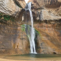
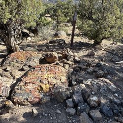
I have had the pleasure of hiking this trail three times now and every time I do, I fall in love all over again. This is a really fun 6.2 mile out and back hike. The falls at the end are the highlight of your hike and well worth hanging out and enjoying this beautiful area. Cliffs abound all around you and a gorgeous creek follows you all the way to the stunning 126 foot waterfall. These falls are one of very few flowing waterfalls in the Utah desert. They are absolutely spectacular! Lots of stops along the way to learn about the geology of the area and flora and fauna. There are also petroglyphs along the way. They can be hard to see but once you know where they are, you will always see them. Parking is provided in a small lot but get there early to score a spot. Small fee to park and use the restrooms before heading out on the trail as there are no restrooms on the trail or at the falls. Camping is also available here. Bring a bathing suit to enjoy this chilly water in the summer but be aware as about a year ago two large boulders crashed down into the water below. Thank goodness no one was hurt but we always need to be aware of Mothers Nature power. Remember to Leave No Trace except your big smiles of joy! Happy Adventuring! read more


Incredible hike with stunning views at every turn. Easy enough for kids. Spectacular waterfall at the end. Be sure to grab a guide before the start so you can read about the marked features along the way. Parking runs out quickly. read more


3 years ago
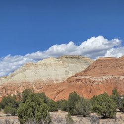
Directional signs to the park are well placed and easy to see. Entrance to the park is on narrow road and park parking is limited. There are areas along the park entrance to be used as overflow. The entrance to the trail is well marked as is the trail it self. There is limited shade for the first two miles, then about the third mile it cools down a little. This trail does not have much elevation change, but the trail is very sandy which can make it more difficult. This trail end with a pristine 126' high waterfall that dumps into a small pool at the bottom. Very refreshing!! read more


I absolutely loved this hike! My husband and I completed the 6-mile out-and-back trek on a cool October morning without a lot of people on the trail. The 126-foot waterfall is beautiful and we desert folk are so appreciative that we got to see it since Vegas does not offer any falls like these. The trail is not too strenuous; for the most part it's flat with a few spots where you have to maneuver up over some rocks. You'll encounter beautiful trees which are currently showing off their fall colors. You'll hear the peaceful sound of the water from the creek. When you get to the waterfall, you can sit on a log and just admire its beauty. Be sure to take advantage of the clean restrooms at the parking lot before you set out as there are no facilities on the trail. Pack out what you pack in. Leave no trace except the smiles on your face--happy trails! read more


From the trailhead to the falls and back measured out to be 6.3 miles with 200 feet of elevation gain and loss. My son, his wife, and I took three hours to do this hike, including stopping to look at the well-marked petroglyphs, granary, beaver pond, and waterfall, marveling at the spectacular falls, creek and canyon, plus time to chat with other hikers and their dogs. We were advised to arrive early. We got to the trailhead by 8:30 on a cool April Wednesday morning. There was plenty of parking at that hour, but the trailhead lot was full to overflowing by our 11:30 a.m. return, with cars, SUVs, campers, and other vehicles jockeying for spots in the lot, along the driveway, and out on the road. BLM charges $5 for a parking tag, cash only. Lots of folks had dogs, some delightful, others not so much. As an out-and-back hike, this trail is great for anyone with a decent balance (there's some slight rock climbing, none requiring hands and knees). Short stretches of the trail are narrow, but none without "pull-outs" within short range. Do the whole thing, or turn around if and when you start to feel uncomfortable The pool and waterfall are spectacular. We easily spent 15-20 minutes just taking in the view. We did find a *big* mountain lion track near the waterfall (yes, I know the difference between a dog print and a mountain lion print). read more

Absolutely fell in love with this place. It costs $5 to get in and there is ample parking. It is roughly a 6 mile hike round trip. There is fine sand everywhere on the trail so it will definitely give you a work out but at least it's easy on the joints. I recommend going early in the summer months because it gets very hot and sunny. Take plenty of water! I took 2 liters and drank most of it. I saw many people bring their dogs and I felt bad for the poor doggos as I'm sure the sand was burning the soles of their paws. Be smart and put shoes on your dog, people! Good thing there is plenty of water from the creek to cool off and some shade. The waterfall is magnificent. It's such a nice place to chill, cool down and take pictures. There is also overnight camping which I'm definitely interested in. I will definitely be back! read more


Beautiful 6 mile out and back dog friendly hike. Some climbing over boulders but easily could be done with kids. Beautiful waterfall at the end. We camped and then walked over to the hike from our spot. Awesome campgrounds with the creek flowing right by the spots. Firepits with grill attachments at each spot as well as a firepit and separate grill out front by the parking for public day use. Things to note No phone service in the area Heavily trafficked Bring lots of water as there isn't much shade during the hike Lots of cacti off the trail so watch your dogs and kids read more


Beautiful waterfall in the Grand Staircase - Escalante. I visited here on my way from Capitol Reef to Bryce Canyon in late November. It was cold but you feel incredibly warm in the patches of sunlight during this time. I had the whole trail to myself and had a beautiful view of the waterfall at the end. It was a 6 mile round trip hike and took a couple hours. It's relatively flat so not too difficult at all. Regardless of the weather, you have to take a dip in the water at the end! read more


3 years ago
Our (my wife and I) extended labor day journey started here at Calf Creek Campground recreation area. Daily parking is $5 and overnight camping is $15 per car. There are limited parking spaces, about 10 and camping sites, maybe 15. Both Go super fast so I would suggest getting there before 10am in order to secure a spot. The campsites themselves are all first come, first serve. All have a central drinking water pump, one central outhouse (actually pretty clean and sanitary) toward the back and a regular bathroom with 3 stalls towards the front of the recreation area. Individually, each site have there own BBQ grill and fire pit while luckily others have canopies and picnic benches. If you're feeling adventurous there is the Lower Calf Creek Trail that leads to a 126 ft high waterfall and (refreshing for me but freezing for my wife) swimming pool. The trail itself is about a 6 mile round trip hike through some forestry, shrubbery, rocks and sand. There are slight elevation and climate changes so make sure you bring enough water an proper clothing. Now go get your adventure on!! read more


You have to check out the lower Calf Creek Falls for the most amazing waterfall when you are in Escalante. It's a 5.8 miles rounds trip that should take about 2 hours to finish. The trails takes you from the oasis through the valley and eventually you will be led to the end where you will see one of the highest and luscious waterfall ever. I consider the hike fairly easy. Not much inclines to worry about and the trail is very sandy. I felt like I was walking on a beach. It was also nice there were plenty of shades along the way. Private parking is available for a $5 fee. Spaces are limited. If you want to avoid paying $5, you can also park along the road before the entrance of the private parking lot. I would advise to come before 9 am in order to catch a parking space in the parking lot. You can also camp here for a fee to check out both the upper and lower Calf Creek Falls. read more

6 years ago
Such a beautiful waterfall hike in Escalante. This review in kinda late bc we went down to South for a spontaneous trip around July which is mid summerBring tons of water if you're planning to go here during summer, the trail is pretty sandy so if you bring your fur friends make sure to let them wear their hiking shoes too ! The sand gets really hot and uncomfortable if you're not wearing shoes(Tevas are not recommended) but you can bring an extra pair if you would like to soak in the water. That was a really fun trip and I would definitely go back next hiking season. read more

6 years ago
Go early or late in the day. About one miles is all under direct sun. Once you get there: it's very nice. It's small so it can get crowded. The water is clean and cold. Take about 2liters or more on the hike. read more


8 years ago
8 years ago
Wow!! This is a 6 mile round trip hike. It's "mostly" flat but there are some step ups and downs along the way. Amazing scenery every step of the way. Really amazing things like petroglyphs can be viewed across the Canyon-pick up a free trail guide at the trail head and the location is clearly marked. Of course the pay off is the gorgeous waterfall, pool and hanging gardens at the end of the first 3 miles!! It is worth every step! BRING WATER! There are no bathrooms and no drinking water after the trail head. It took us 2 1/2 hours in-stopping to take dozens of pictures and talking to everyone we met along the trail-after relaxing and being refreshed at the waterfall it took us 1 hr 45 minutes back out. We are in our 50s and not regular hikers-younger folks and experienced hikers did the trip in much shorter time. read more


10 years ago
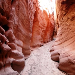
3 mile hike one way so be prepared for a 3 to 4 hour adventure. There are plenty of different types of nature things (?) to be seen..desert, rivers, waterfalls, mountains. If you don't grab the trail guide be sure to look out for wall paintings on marker #8. Look directly across toward the mountains and you'll be able to see three "guys" who were painted on the canyon wall. read more


10 years ago
More info about Calf Creek Falls Lower
Scenic Byway 12
Boulder, UT 84716
Directions
Hours
Outdoor Amenities
Other Amenities
Calf Creek Falls Lower Reviews in Other Languages
Ask the Community - Calf Creek Falls Lower
Review Highlights - Calf Creek Falls Lower


Calf Creek Falls Lower - hiking - Updated July 2026
Best of Boulder
People found Calf Creek Falls Lower by searching for…
Public Shower in Boulder, Utah
Hiking Trails With Waterfalls in Boulder, Utah
Natural Hot Springs in Boulder, Utah
Places to Take Pictures in Boulder, Utah
River Swimming in Boulder, Utah
Dog Friendly Trails in Boulder, Utah
Rock Climbing in Boulder, Utah
Off Road Trails in Boulder, Utah
Rv Dump Station in Boulder, Utah
Beautiful Views in Boulder, Utah
Camping Sites in Boulder, Utah