Boundary Trail! Okay...so for my visit and exploration of Mount St. Helens...I found Boundary Trail to be most useful in achieving the best views of this dormant volcano.
Boundary Trail was certainly not the best hike I've been on...but it afforded me the most clear and uninterrupted views of Mt. Saint Helens.
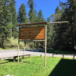
It's located right next to the main - Johnston Ridge Observatory...in the heart of Mt. St. Helens and the most popular and frequented section of the national monument.
In all...you can visit Mt. St. Helens from different entrances...north, south, east and west. But here at the Johnston Ridge Observatory...you're offered fantastic views along with inside the building being a Visitors Center for questions you may have with a park ranger.
Also here there's a little gift shop and theater to watch a film. But this...Johnston Ridge Observatory provides many accessible overlooks of Mt. St. Helens.
If you are interested in hiking and spending some time along a path...then I recommend this Boundary Trail first and foremost!
To find the start for Boundary Trail...from Johnston Ridge Observatory, begin walking up the winding path that says - Eruption Trail...
Along Eruption Trail which sort of navigates around the edge of the parking lot...after maybe 1/2 of a mile you'll then connect with Boundary Trail.
There'll be a clear sign stating Boundary Trail and the few stops and points along the way describing how far exactly you can go...
From the start of Boundary Trail it's....
- 2.2 miles to Devils Point
- 2 miles to Jct Truman TR 207
- 3 miles to Harry's Ridge TR 1E
- 12 miles to Norway Pass Trailhead
For me...I hiked to Devils Point. From Devils Point you then had to do so real climbing and maneuvering to continue further along....which meant there could have been a feasible pathway to hike all the way to the top of Mt. St. Helens. But....
I found trying to attempt going further past this Devils Point Vista dangerous. Since I didn't trek any further...I warn anyone that the trail appeared to continue with possibly having to balance along a ledge and not much more visual accessibility. So...past Devils Point, I'd caution to first ask a park ranger what lies ahead.
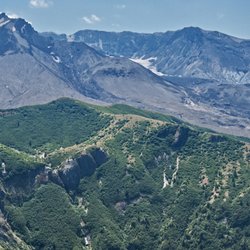
Otherwise I turned around and headed back towards Johnston Ridge. In all, hiking 2.2 miles each way to Devils Point offered many opportunities to stop and grab photos of majestic Mount St. Helens in the background!
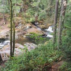
Along the trail...there were benches for you to sit down on and just relax simply facing the volcano. If you bring lunch with you...you can certainly hang out, eat and enjoy the views.
I will say that Boundary Trail is a moderate hike....not easy but not too difficult. The elevation gain was about 600 - 700 feet along the 2.2 miles each way.
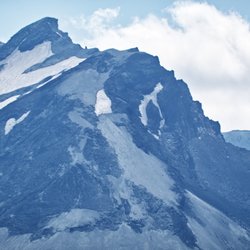
And...at Devils Point...the scenery was simply terrific! I felt like this overlook was probably the closest to Mt. St Helens I could have gotten. When I took pictures I really didn't have to zoom in with my lens.
I visited Mt. St. Helens over the summer time back in August and this Boundary Trail was virtually empty. No one was really hiking the trail. Granted it was very hot outside, but since you drive all the way just to reach Johnston Ridge...where you can simply pier out onto Mt. St. Helens from the observatory...well then, who wouldn't want to do some hiking???
So yes, I found this Boundary Trail to be the most fulfilling way to absorb the setting and surroundings of Mount St. Helens. It's not too long of a hike...but good enough to really capture the essence for this statuesque landmark tucked away in Southern Washington.
Finally, I got so fortunate in visiting here on a picture perfect clear day...without a cloud in the sky! Although...I was hoping for some snow capped peaks around Mt. St. Helens....but never got any. It's still just made up of a very arid, dry and remote post-eruption terrain. read more