Mt St Helens Photos


More like Mt St Helens
Recommended Reviews - Mt St Helens
Start your review...

Reviews With Photos

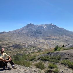
I was really young when Mount St. Helens erupted in 1980. I have vague memories of my parents watching the news report about it on TV. Mount St. Helens is the most active volcano in the contiguous United States and is located in the Pacific Northwest region. Its major eruption was on May 18, 1980 and killed fifty-seven people. Many homes, railways, bridges and highways were destroyed. The eruption was a lateral eruption that reduced its summit by over a thousand feet and left a one mile crater. Even though scientists predict eruptions in the distant future, Mt. St. Helens is a popular hiking spot and tourist attraction. It is also a climbing destination for both beginning and experienced mountaineers. It was established as a national monument in 1982. I first saw this volcano on a high school bus trip up the Western coast. I was in Washington recently and wanted to check it out again. I was able to see this stratovolcano from the Windy Ridge Viewpoint area. The lookout point is only five miles away from Mount St. Helens. It is very scenic and has a number of hiking trails. You can get a close-up view of the volcano's crater and panoramic views of the landscape that radically changed after the eruption and landslide. I took the hour-long winding road from Randle, WA to Windy Ridge. You can see other mountains in the distance like Mount Hood, Mount Adams and Mount Rainier on the drive over. There are lots of beautiful viewpoints and other sites of interests on the way. Spirit Lake is also on the drive and has all sorts of floating logs in it from trees that swept into the lake during the eruption.

I'm writing specifically about the Windy Ridge Interpretive Site, located to the northeast of Mt St Helens. It is an amazing viewpoint, but, as of summer 2024, please do your homework if you are thinking about visiting. For us, coming from the Portland area, we've traditionally left I5 at Woodland, and taken visitors to Ape Caves and/or Lava Canyon on the way to Forest Road 25, up the east side of Mt St Helens. As of 2024, a sizeable piece of Rt 25 is closed due to a landslide, and will remain closed until 2025 at the earliest. Currently, the only way to get to Windy Ridge is to continue north of Winlock on I5, and take Rt 12 eastbound, where you'll get on Forest Road 25 in Randle. Once you've found an open road, your troubles aren't over - both Forest Road 25, and Forest Road 99 that takes you the last 16 miles to Windy Ridge, are in need of repair in multiple places. The last 35 miles of the trip take well over an hour to navigate. That being said, the experience of driving through the blast zone, and getting to walk over hillsides with a view directly into the crater is not to be missed. Over 40 years after the eruption, it's amazing to see the results of what happened in 1980. It's the closest you'll ever come to walking on the moon. Also as of 2024, the restrooms at Windy Ridge are closed. So, don't expect any amenities - you'll find those at the visitor's centers closer to I-5. But, at least one of those is currently closed due to a landslide blocking that road.

[Review of summitting Mt St Helens] // PERMIT - You need a permit April 1-Oct 31 to hike to the summit. We saw a few spots open on a Wednesday in Aug and decided to go! They cost $18 pp with fees. I believe you can cancel/reschedule prior to printing out the permit, excluding the fees. https://www.recreation.gov/permits/4675309 - May 15-Oct 31 there's a limit of 110 climbers per day, which was great because there were quite a few moments we were alone hiking and it was very peaceful // DRIVE/ PARKING TO THE TRAILHEAD - Driving from PDX, it's a 1.5 hr drive that's windy and dark at 25-50 mph. It was pretty tough, especially because we started driving at 4:30am. - Once you enter the park, there's a 2-3 mi stretch of unpaved gravel road to get to Climber's Bivouac that I drove 5-10mph because there were some rugged spots. But the car came out fine - just have to go super slow - I had purchased America the Beautiful interagency card from REI and put that on my dashboard. Otherwise, you can purchase a $5 day pass at the parking lot (you put $5 cash into an envelope and slit it into a box) or online. Or if you have the annual forest park pass, you put that on - At 6am, the parking lot was 60-70% full. We found a spot next to the map/signage. - There is 1 vault toilet but there was no toilet paper. // THE CLIMB - PHASE 1 FOREST - This is the easiest part of the hike and shaded. It's also a gradual incline. - The markers are bright blue diamonds nailed to trees. // THE CLIMB - PHASE 2 BOULDERS - Once you exit the forest, you'll see a sign that says, "Permit required beyond this point." - You will be scrambling through miles of boulders. This is where your gardening/ work gloves will come in handy. - It was difficult to know where the trail was - even when the markers (wooden poles) marked where to go. // THE CLIMB - PHASE 3 SAND - This is the worst part of the hike. We were already to tired from climbing through rocks. Imagine trying to walk through sand you find on a beach at an incline. It was terrible, to say the least. - Poles are great to have here (we saw 80-90% with poles throughout the hike) - Neck gaiters and sunglasses help to keep the sand out of your eyes and mouth. // THE SUMMIT - The view is amazing and totally worth it. The "true summit" is towards the left, you climb a little to view the entire crater. We saw a couple celebrating with champagne and a picnic. - It was quite windy at the top and a bit chilly. // DESCENT/ TOTAL TIME - We started hiking at 6:30am. We summitted at 1:30pm. Ascent = 7 hrs - We started our descent at 2pm. Arrived at the parking lot 8:30pm. Descent = 6.4 hrs - The descent was also treacherous because our legs were so tired. There's an easier sandy trail that you can take instead of traversing through boulders again. - We took many breaks - By the time we were in the forest part again, it was growing dark. We didn't see anyone. // WHAT TO PACK - Water (2.5L wasn't enough) - Neck gaiter (to keep sand out) - Gaiter (for your feet. Game changer for keeping rocks & sand out when you're descending) - Hiking poles (made it easier to hike through the sand - I didn't bring any but wished I had) - Food (we ate maybe 4 protein bars each throughout the day - Sunscreen (we still got burnt. the sun is harsh - make sure to reapply every 1.5 hrs or so) - lip balm w/ SPF - Hat - gardening/ work gloves ( A MUST) // WHAT TO WEAR - In late Aug, it was pretty warm. Even though the high was 70ish and then at the summit 55 degrees, I was wearing a tank top the whole hike up with long hiking pants (they were convertible so I took off the bottom portion but then was subject to getting scuffed up by the rocks). I had a long sleeve shirt that I put on at the summit.

I spent a few hours - half a day exploring Mt. St. Helens National Volcanic Monument. It was a real simple journey for me. Basically it was a leisurely drive through and along the grounds until I arrived at the viewing pinnacle of Johnston Ridge Observatory. Once here, I got out of my car and was afforded panoramic views of Mt. St. Helens free standing in the distance along with the rugged terrain where lava once flowed down during an eruption from back in 1980. Here at the Johnston Ridge Observatory, the air was fresh and crisp and there were really nice moments to walk around and snap pictures of the scenic landscape from multiple viewpoints and overlooks. During the day I visited in September, the top of Mt. St. Helens was covered in fog, but I was still able to view it for the most part with some snow covering and capping the peak. And, the land surrounding this enormous volcano was still grey and brownish....sort of reminiscent of a barren countryside still suffering the effects of the last eruption that destroyed the area's natural beauty. Overall, it was still very humbling to gaze out towards Mt. St. Helens and be in the presence to appreciate such a powerful natural wonder. Then I went inside Johnston Ridge Observatory where I was able to pick up little gifts and souvenirs from my time at this extraordinary national monument. Also, I stuck around and watched 2 different park films that gave insight into Mt. St. Helen's past and how it came to be such a high profile landmark. I believe you can do some hiking here outside of the observatory but after getting some great pictures of Mt. St. Helens, I was content with continuing along my itinerary south towards Oregon and eventually Crater Lake National Park. I was a fan of Mt. St. Helens National Monument and casually driving the road towards Johnston Ridge Observatory. What's most convenient about visiting this unique volcano is that it's situated right near a bunch of highly worthwhile parks and attractions including Mt. Rainier NP, NorthWestTrek Wildlife Park and Olympic NP.

Truly amazing!! While my father has been visiting for the week I have had the privilege of visiting some of the most breathtaking areas in the Pacific Northwest. Today we ventured to Mt Saint Helens National Monument. We stopped at the Visitor 's Center just east of I-5 on exit 49. There is a $5 fee to tour the exhibits and watch the documentary film in the theater. We learned a great deal about Mt Saint Helens and the eruption of 1980. After leaving the Visitor Center we continued East to the National Monument. We were in complete awe of the majestic volcano. It is very hard to fathom the severity of the eruption and the massive landslides created by it. One can only wonder what it was like to be there. The area is healing slowly and evidence of mother nature's ability to persevere is very apparent.

Before my time in the Northwest there were more than several pointy mountains in view from Portland. St Helens was one about 60 miles NNE of Portland in Washington's Gifford Pinchot national forest. In 1980 it had a volcanic eruption that created a huge crater. The now flat topped mountain is easily visible from Portland today. There is climbing and there is climbing. One is a strenuous walk up. The other is technical: teams, ropes, safety, tools. Mt St Helens is a walk up when dry and generally non-technical in snow. I cannot stress this enough, when you get to the top, which is likely snow or glacier covered year round, you are in the technical realm at the edge. If you want to look down and photograph the crater, which obv is the point, you will be on a cornice of volcanic sand and snow that could easily collapse. It's several thousand feet down. Set up anchors and belays. It has collapsed and there have been climbers who fell a great distance and had to be rescued from that situation. They lived, thankfully, but no guarantees. It's easy to find your way up, just keep walking towards the horizon. But it is seriously hard to find your way back down to your exact vehicle location. GPS tools which work disconnected from the cell phone network are a must! Permits and check in/out/friends/emergency contacts is a good strategy should you have a problem. In-person permits available at http://www.yelp.com/biz/lone-fir-resort-cougar. Want to hike an active volcano, making a new peak and occasionally sending up steam? Climb Mt St Helens! (Yelp is street address and zip code oriented. Odd public lands have neither...)

08/28/11 (Last Visited) The drive up to Mt. St. Helens itself is outstanding. The site has Forest Learning Center which is located inside the blast zone of Mount St. Helens. It's displays and exhibits focus on the geology and natural history of the park and forests. Johnston Ridge Observatory offers a great 20-minutes movie for the eruption of the volcano, has many displays, gift shop, ranger tours. Outside is an observatory deck offering excellent views of the volcano in a clear day where we listened to an interesting ranger talk as the volcano vented gasses in the background. Make sure to watch for Roosevelt Elk. We saw several. Take your time reading the explanatory text around the photos as they provide greater perspective for the events of 1980. Stunning views, amazing story and something that should not be missed between Seattle and Portland. Make sure that you fill gas and have enough food and water with you. It is not a short ride from the main highway to get there, but the views and the countryside are worth it. As I said, go if you have the opportunity. We really enjoyed our visit and spent a good portion of the day here.

And BOOM goes the mountain... Mount St. Helens is an explosive part of Washington and American history. Anyone alive during the major 1980 eruption will never forget it. For those born since, they will barely believe it. Both are reasons that Mt. St. Helens is a must see stratovolcano in Western and Southwest Washington More about the Mount St. Helens National Volcanic Monument: * Monument Pass required Adult: $8 * 15 and younger: free * Located in the 1.3 mil acre Gifford Pinchot National Forest * Johnston Ridge Observatory is the closest visitor center * Be sure to watch the video ... and wait til the end * It's only open mid-May - October. * Coldwater Science and Learning Center is open weekends during Winter * 200 miles of trails offer exploration & views * Make time for Coldwater Lake with paved trail * Loowit Trail can take you all the way around the mountain * Hummocks Trail is short (2.8 mi) & easy * Harmony Trail takes you to "Spirit Lake" * Plan accordingly for safety * Pets are prohibited at ALL recreation sites & trails * Great Viewpoints: Loowit, Castle Lake, & Elk Rock * You can skip the $5 Visitor Center near Silver Lake unless you want to get a map for the drive up the mountain. The amazing scenery of Mount St. Helens gives you a chance to explore the destructive and restorative power of Mother Nature that is sure to impress young and old alike.

If you're anywhere between Seattle and Portland and you don't take this detour, you're not living the American dream. Everything is breathtaking, there is plenty to stop and see without having to be a serious hiker or spend days in the wilderness (which you can also do!). Pictures do the landscape more justice than words ever will, and I'm so so so glad we took part of our day to stop and climb around/take photos. After all, you never know when the next eruption will be, so you'd better take advantage while you can.

If you have the chance and are in reasonably good shape this is an amazing adventure. I highly recommend going with someone who knows the mountain, but you could manage without. Take lots of water, micro spikes, snacks, and hiking poles. If you go in the spring be ready to use lots of clothing layers as you'll get hot then cold then wet. Also be ready to glacade down the mountain if you have enough snow. This is the best part. I have not hiked in the summer, but I've heard it's much harder and there is no glacade.

Eerily amazing! This was a mini weekend getaway for us during the July 4th weekend. Drove to the state of WA from CA to visit this piece of history that happened in my lifetime. Since we didn't have a lot of time we just concentrated on stops to the Visitor Centers and Gift shops along the way. We purchased an Annual Pass on this trip as we always get our money's worth for this $80 pass. We arrived at this place a little too early and the visitor centers were still closed so we worked our way from the Johnston Ridge Observatory on SR 504 and backtracked. From the parking lot we followed the trail up and around while catching magnificent views of the volcano thinking that yikes! if it erupted now we'd have no chance of survival. Inside the observatory building we watched a short film on the history of the eruption. We didn't have to pay the fee since we already purchased an annual pass. After the film the curtain lifted to expose the mighty volcano. It was an awe-inspiring view as you have the north side view of the mountain which was blown away in the eruption! History states that at 8:32 Sunday morning, May 18, 1980, Mount St. Helens erupted after being shaken by a 5.1 magnitude earthquake. The scars of the lateral explosion it left is seen in parts of our drive in the surrounding landscape. 35 years of legacy by an eruption that lasted for 9 hours. A little trivia: This volcano is well known for its ash explosions and pyroclastic flows. We stopped at the Loowit Viewpoint and Castle Lake Viewpoint to take some photos and get different views of the volcano. Next stop was at the Forest Learning Center (approx 10 miles west of Johnston Ridge Observatory). It is more of a facility that is great resource for schools, research, education and science groups. Still on SR 504 on Spirit Lake Highway our last stop was at the Hoffstadt Bluffs Visitor Center. There is a nice restaurant in this area and they offer helicopter tours to view the crater and Spirit Lake. The tour is approx 25 mins. No hiking for us in this visit, maybe next time, but each year many climbers make the journey to the crater rim. FYI. Permits are required above 4,800 feet year-round. Very impressive and eerily beautiful! Review #0314

I've been to Washington state on vacation several times and never made it to Mt St Helen's. This year we made the move and live in the Olympia area. I have always wanted to go here. The high volcanoes in the state are so awe inspiring. Just amazing how far they can be seen. We took the drive to Mt St Helen's and was amazed at the scenery. We stopped at the visitors center and walked around the lake before making the drive to the viewing center. Beautiful drive. Pictures never do these mountains or volcanoes justice. During the drive, there is points when you make a turn and the volcano makes a spectacular appearance. So we would pull over, in a safe area, lots of snow on our trip and the pull offs were not accessible. Couple spots were it was manageable as snow had been cleared. If seeing this doesn't make you shout, OMG, there is something wrong with you. We didnt stay long at the viewing center. We had our dog with us so couldn't explore much. But we have no regrets. Ready to go back !

I have plans to climb Ranier 7/2026, but I've never had exposure to snow trekking. My friend graciously offered to give me a 101 crash course on MSH. Of course, I took the opportunity and flew to Portland and drove out to MSH. The day was perfect and the hike was incredible. I learned so many new skills. MSH is just beautiful and we caught the sunrise on a clear day. Get your parking before hand. I grabbed mine at REI in Portland. Please come and create your own adventure. read more


1 year ago
Mount Saint Helens is a must see. The beauty and history is unmatched. It's a great place to spend the day. read more


Mt St Helens should be on everyone's bucket list. Talk about a force of nature! If you know the history about Mt St Helens and how it is an active stratovolcano and the destruction it cost in 1980 you will appreciate it even more. I always say, no picture or words can describe it. Go experience it for yourself. read more


I was really young when Mount St. Helens erupted in 1980. I have vague memories of my parents watching the news report about it on TV. Mount St. Helens is the most active volcano in the contiguous United States and is located in the Pacific Northwest region. Its major eruption was on May 18, 1980 and killed fifty-seven people. Many homes, railways, bridges and highways were destroyed. The eruption was a lateral eruption that reduced its summit by over a thousand feet and left a one mile crater. Even though scientists predict eruptions in the distant future, Mt. St. Helens is a popular hiking spot and tourist attraction. It is also a climbing destination for both beginning and experienced mountaineers. It was established as a national monument in 1982. I first saw this volcano on a high school bus trip up the Western coast. I was in Washington recently and wanted to check it out again. I was able to see this stratovolcano from the Windy Ridge Viewpoint area. The lookout point is only five miles away from Mount St. Helens. It is very scenic and has a number of hiking trails. You can get a close-up view of the volcano's crater and panoramic views of the landscape that radically changed after the eruption and landslide. I took the hour-long winding road from Randle, WA to Windy Ridge. You can see other mountains in the distance like Mount Hood, Mount Adams and Mount Rainier on the drive over. There are lots of beautiful viewpoints and other sites of interests on the way. Spirit Lake is also on the drive and has all sorts of floating logs in it from trees that swept into the lake during the eruption. read more


I'm writing specifically about the Windy Ridge Interpretive Site, located to the northeast of Mt St Helens. It is an amazing viewpoint, but, as of summer 2024, please do your homework if you are thinking about visiting. For us, coming from the Portland area, we've traditionally left I5 at Woodland, and taken visitors to Ape Caves and/or Lava Canyon on the way to Forest Road 25, up the east side of Mt St Helens. As of 2024, a sizeable piece of Rt 25 is closed due to a landslide, and will remain closed until 2025 at the earliest. Currently, the only way to get to Windy Ridge is to continue north of Winlock on I5, and take Rt 12 eastbound, where you'll get on Forest Road 25 in Randle. Once you've found an open road, your troubles aren't over - both Forest Road 25, and Forest Road 99 that takes you the last 16 miles to Windy Ridge, are in need of repair in multiple places. The last 35 miles of the trip take well over an hour to navigate. That being said, the experience of driving through the blast zone, and getting to walk over hillsides with a view directly into the crater is not to be missed. Over 40 years after the eruption, it's amazing to see the results of what happened in 1980. It's the closest you'll ever come to walking on the moon. Also as of 2024, the restrooms at Windy Ridge are closed. So, don't expect any amenities - you'll find those at the visitor's centers closer to I-5. But, at least one of those is currently closed due to a landslide blocking that road. read more


[Review of summitting Mt St Helens] // PERMIT - You need a permit April 1-Oct 31 to hike to the summit. We saw a few spots open on a Wednesday in Aug and decided to go! They cost $18 pp with fees. I believe you can cancel/reschedule prior to printing out the permit, excluding the fees. https://www.recreation.gov/permits/4675309 - May 15-Oct 31 there's a limit of 110 climbers per day, which was great because there were quite a few moments we were alone hiking and it was very peaceful // DRIVE/ PARKING TO THE TRAILHEAD - Driving from PDX, it's a 1.5 hr drive that's windy and dark at 25-50 mph. It was pretty tough, especially because we started driving at 4:30am. - Once you enter the park, there's a 2-3 mi stretch of unpaved gravel road to get to Climber's Bivouac that I drove 5-10mph because there were some rugged spots. But the car came out fine - just have to go super slow - I had purchased America the Beautiful interagency card from REI and put that on my dashboard. Otherwise, you can purchase a $5 day pass at the parking lot (you put $5 cash into an envelope and slit it into a box) or online. Or if you have the annual forest park pass, you put that on - At 6am, the parking lot was 60-70% full. We found a spot next to the map/signage. - There is 1 vault toilet but there was no toilet paper. // THE CLIMB - PHASE 1 FOREST - This is the easiest part of the hike and shaded. It's also a gradual incline. - The markers are bright blue diamonds nailed to trees. // THE CLIMB - PHASE 2 BOULDERS - Once you exit the forest, you'll see a sign that says, "Permit required beyond this point." - You will be scrambling through miles of boulders. This is where your gardening/ work gloves will come in handy. - It was difficult to know where the trail was - even when the markers (wooden poles) marked where to go. // THE CLIMB - PHASE 3 SAND - This is the worst part of the hike. We were already to tired from climbing through rocks. Imagine trying to walk through sand you find on a beach at an incline. It was terrible, to say the least. - Poles are great to have here (we saw 80-90% with poles throughout the hike) - Neck gaiters and sunglasses help to keep the sand out of your eyes and mouth. // THE SUMMIT - The view is amazing and totally worth it. The "true summit" is towards the left, you climb a little to view the entire crater. We saw a couple celebrating with champagne and a picnic. - It was quite windy at the top and a bit chilly. // DESCENT/ TOTAL TIME - We started hiking at 6:30am. We summitted at 1:30pm. Ascent = 7 hrs - We started our descent at 2pm. Arrived at the parking lot 8:30pm. Descent = 6.4 hrs - The descent was also treacherous because our legs were so tired. There's an easier sandy trail that you can take instead of traversing through boulders again. - We took many breaks - By the time we were in the forest part again, it was growing dark. We didn't see anyone. // WHAT TO PACK - Water (2.5L wasn't enough) - Neck gaiter (to keep sand out) - Gaiter (for your feet. Game changer for keeping rocks & sand out when you're descending) - Hiking poles (made it easier to hike through the sand - I didn't bring any but wished I had) - Food (we ate maybe 4 protein bars each throughout the day - Sunscreen (we still got burnt. the sun is harsh - make sure to reapply every 1.5 hrs or so) - lip balm w/ SPF - Hat - gardening/ work gloves ( A MUST) // WHAT TO WEAR - In late Aug, it was pretty warm. Even though the high was 70ish and then at the summit 55 degrees, I was wearing a tank top the whole hike up with long hiking pants (they were convertible so I took off the bottom portion but then was subject to getting scuffed up by the rocks). I had a long sleeve shirt that I put on at the summit. read more


I spent a few hours - half a day exploring Mt. St. Helens National Volcanic Monument. It was a real simple journey for me. Basically it was a leisurely drive through and along the grounds until I arrived at the viewing pinnacle of Johnston Ridge Observatory. Once here, I got out of my car and was afforded panoramic views of Mt. St. Helens free standing in the distance along with the rugged terrain where lava once flowed down during an eruption from back in 1980. Here at the Johnston Ridge Observatory, the air was fresh and crisp and there were really nice moments to walk around and snap pictures of the scenic landscape from multiple viewpoints and overlooks. During the day I visited in September, the top of Mt. St. Helens was covered in fog, but I was still able to view it for the most part with some snow covering and capping the peak. And, the land surrounding this enormous volcano was still grey and brownish....sort of reminiscent of a barren countryside still suffering the effects of the last eruption that destroyed the area's natural beauty. Overall, it was still very humbling to gaze out towards Mt. St. Helens and be in the presence to appreciate such a powerful natural wonder. Then I went inside Johnston Ridge Observatory where I was able to pick up little gifts and souvenirs from my time at this extraordinary national monument. Also, I stuck around and watched 2 different park films that gave insight into Mt. St. Helen's past and how it came to be such a high profile landmark. I believe you can do some hiking here outside of the observatory but after getting some great pictures of Mt. St. Helens, I was content with continuing along my itinerary south towards Oregon and eventually Crater Lake National Park. I was a fan of Mt. St. Helens National Monument and casually driving the road towards Johnston Ridge Observatory. What's most convenient about visiting this unique volcano is that it's situated right near a bunch of highly worthwhile parks and attractions including Mt. Rainier NP, NorthWestTrek Wildlife Park and Olympic NP. read more


Truly amazing!! While my father has been visiting for the week I have had the privilege of visiting some of the most breathtaking areas in the Pacific Northwest. Today we ventured to Mt Saint Helens National Monument. We stopped at the Visitor 's Center just east of I-5 on exit 49. There is a $5 fee to tour the exhibits and watch the documentary film in the theater. We learned a great deal about Mt Saint Helens and the eruption of 1980. After leaving the Visitor Center we continued East to the National Monument. We were in complete awe of the majestic volcano. It is very hard to fathom the severity of the eruption and the massive landslides created by it. One can only wonder what it was like to be there. The area is healing slowly and evidence of mother nature's ability to persevere is very apparent. read more


Before my time in the Northwest there were more than several pointy mountains in view from Portland. St Helens was one about 60 miles NNE of Portland in Washington's Gifford Pinchot national forest. In 1980 it had a volcanic eruption that created a huge crater. The now flat topped mountain is easily visible from Portland today. There is climbing and there is climbing. One is a strenuous walk up. The other is technical: teams, ropes, safety, tools. Mt St Helens is a walk up when dry and generally non-technical in snow. I cannot stress this enough, when you get to the top, which is likely snow or glacier covered year round, you are in the technical realm at the edge. If you want to look down and photograph the crater, which obv is the point, you will be on a cornice of volcanic sand and snow that could easily collapse. It's several thousand feet down. Set up anchors and belays. It has collapsed and there have been climbers who fell a great distance and had to be rescued from that situation. They lived, thankfully, but no guarantees. It's easy to find your way up, just keep walking towards the horizon. But it is seriously hard to find your way back down to your exact vehicle location. GPS tools which work disconnected from the cell phone network are a must! Permits and check in/out/friends/emergency contacts is a good strategy should you have a problem. In-person permits available at http://www.yelp.com/biz/lone-fir-resort-cougar. Want to hike an active volcano, making a new peak and occasionally sending up steam? Climb Mt St Helens! (Yelp is street address and zip code oriented. Odd public lands have neither...) read more

9 years ago
08/28/11 (Last Visited) The drive up to Mt. St. Helens itself is outstanding. The site has Forest Learning Center which is located inside the blast zone of Mount St. Helens. It's displays and exhibits focus on the geology and natural history of the park and forests. Johnston Ridge Observatory offers a great 20-minutes movie for the eruption of the volcano, has many displays, gift shop, ranger tours. Outside is an observatory deck offering excellent views of the volcano in a clear day where we listened to an interesting ranger talk as the volcano vented gasses in the background. Make sure to watch for Roosevelt Elk. We saw several. Take your time reading the explanatory text around the photos as they provide greater perspective for the events of 1980. Stunning views, amazing story and something that should not be missed between Seattle and Portland. Make sure that you fill gas and have enough food and water with you. It is not a short ride from the main highway to get there, but the views and the countryside are worth it. As I said, go if you have the opportunity. We really enjoyed our visit and spent a good portion of the day here. read more


9 years ago
And BOOM goes the mountain... Mount St. Helens is an explosive part of Washington and American history. Anyone alive during the major 1980 eruption will never forget it. For those born since, they will barely believe it. Both are reasons that Mt. St. Helens is a must see stratovolcano in Western and Southwest Washington More about the Mount St. Helens National Volcanic Monument: * Monument Pass required Adult: $8 * 15 and younger: free * Located in the 1.3 mil acre Gifford Pinchot National Forest * Johnston Ridge Observatory is the closest visitor center * Be sure to watch the video ... and wait til the end * It's only open mid-May - October. * Coldwater Science and Learning Center is open weekends during Winter * 200 miles of trails offer exploration & views * Make time for Coldwater Lake with paved trail * Loowit Trail can take you all the way around the mountain * Hummocks Trail is short (2.8 mi) & easy * Harmony Trail takes you to "Spirit Lake" * Plan accordingly for safety * Pets are prohibited at ALL recreation sites & trails * Great Viewpoints: Loowit, Castle Lake, & Elk Rock * You can skip the $5 Visitor Center near Silver Lake unless you want to get a map for the drive up the mountain. The amazing scenery of Mount St. Helens gives you a chance to explore the destructive and restorative power of Mother Nature that is sure to impress young and old alike. read more


 - Climbing Near Me")
If you're anywhere between Seattle and Portland and you don't take this detour, you're not living the American dream. Everything is breathtaking, there is plenty to stop and see without having to be a serious hiker or spend days in the wilderness (which you can also do!). Pictures do the landscape more justice than words ever will, and I'm so so so glad we took part of our day to stop and climb around/take photos. After all, you never know when the next eruption will be, so you'd better take advantage while you can. read more


If you have the chance and are in reasonably good shape this is an amazing adventure. I highly recommend going with someone who knows the mountain, but you could manage without. Take lots of water, micro spikes, snacks, and hiking poles. If you go in the spring be ready to use lots of clothing layers as you'll get hot then cold then wet. Also be ready to glacade down the mountain if you have enough snow. This is the best part. I have not hiked in the summer, but I've heard it's much harder and there is no glacade. read more


Eerily amazing! This was a mini weekend getaway for us during the July 4th weekend. Drove to the state of WA from CA to visit this piece of history that happened in my lifetime. Since we didn't have a lot of time we just concentrated on stops to the Visitor Centers and Gift shops along the way. We purchased an Annual Pass on this trip as we always get our money's worth for this $80 pass. We arrived at this place a little too early and the visitor centers were still closed so we worked our way from the Johnston Ridge Observatory on SR 504 and backtracked. From the parking lot we followed the trail up and around while catching magnificent views of the volcano thinking that yikes! if it erupted now we'd have no chance of survival. Inside the observatory building we watched a short film on the history of the eruption. We didn't have to pay the fee since we already purchased an annual pass. After the film the curtain lifted to expose the mighty volcano. It was an awe-inspiring view as you have the north side view of the mountain which was blown away in the eruption! History states that at 8:32 Sunday morning, May 18, 1980, Mount St. Helens erupted after being shaken by a 5.1 magnitude earthquake. The scars of the lateral explosion it left is seen in parts of our drive in the surrounding landscape. 35 years of legacy by an eruption that lasted for 9 hours. A little trivia: This volcano is well known for its ash explosions and pyroclastic flows. We stopped at the Loowit Viewpoint and Castle Lake Viewpoint to take some photos and get different views of the volcano. Next stop was at the Forest Learning Center (approx 10 miles west of Johnston Ridge Observatory). It is more of a facility that is great resource for schools, research, education and science groups. Still on SR 504 on Spirit Lake Highway our last stop was at the Hoffstadt Bluffs Visitor Center. There is a nice restaurant in this area and they offer helicopter tours to view the crater and Spirit Lake. The tour is approx 25 mins. No hiking for us in this visit, maybe next time, but each year many climbers make the journey to the crater rim. FYI. Permits are required above 4,800 feet year-round. Very impressive and eerily beautiful! Review #0314 read more

 - Climbing Near Me")


I've been to Washington state on vacation several times and never made it to Mt St Helen's. This year we made the move and live in the Olympia area. I have always wanted to go here. The high volcanoes in the state are so awe inspiring. Just amazing how far they can be seen. We took the drive to Mt St Helen's and was amazed at the scenery. We stopped at the visitors center and walked around the lake before making the drive to the viewing center. Beautiful drive. Pictures never do these mountains or volcanoes justice. During the drive, there is points when you make a turn and the volcano makes a spectacular appearance. So we would pull over, in a safe area, lots of snow on our trip and the pull offs were not accessible. Couple spots were it was manageable as snow had been cleared. If seeing this doesn't make you shout, OMG, there is something wrong with you. We didnt stay long at the viewing center. We had our dog with us so couldn't explore much. But we have no regrets. Ready to go back ! read more


10 years ago
8 years ago
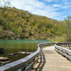
We went to Mt.St.Helens, Johnston Observatory, as well as the other observatories on 504. They all had their own unique character and great information. We also went to the other side of the mountain to Windy Ridge. WOW!!!! I'm so glad we went there, too! It was unbelievable!! The trees were still the same as they were when the blast occurred! I seriously couldn't believe my eyes!!! If you make it over to Mt.St.Helen's, you have to go to Windy Ridge to really get the full impact!!! Incredible!!!! read more


7 years ago
7 years ago
Too cloudy and the boat was a raft instead a pontoon. Very disappointing and ruined the afternoon for our whole party. Should've visited before 1980 when the whole thing was still there. Rainier was alright though, very beautiful mountain! Also, lots of turtles in the lake- look out! read more


10 years ago
9 years ago
Great mountain to climb, but be prepared: this is not just a hiking in the woods. You will need a permit to climb it. It took me 9 hours to go up and climb back down. It is worth it, but, again be prepared read more


8 years ago
11 years ago
We were really pleased that we stopped here, we think it was better than Mt Rainier. It was Just beautiful and we went the back route through Randle, Washington because we were told that the back way was better for nature shots if you didn't care to visit the observatory and we were pleased with our decision because the back way is where you can still see where the volcano exploded. It wasn't busy at all and we felt like the whole mountain was ours! Very educational as well with many observational points along the way with picture opportunities. Amazing!! read more


Hard to imagine that there are 200 miles of trails here, but time sure flies I suppose. I can recall sitting in my front room on a Sunday morning in mid-May of 1980. "Daddy, where is Mt. St. Helens?", said my 4 year old daughter. We could see what I always guessed to be about the top 1200' of the mountain from the front room window in Troutdale. But she was right, it was gone from view with the massive ash plume headed, for the most part, east. The trails on St. Helens have a enough variety for almost every level of hiker, even mountain climbers if you're up for that. I've only been on a couple of the hikes, but the variety is amazing. Hummocks is fairly well shaded by youthful alders, but the Coldwater Creek hikes are exposed to lots of sun, so be forewarned and well watered. The wildflowers are still around to a small extent this far into July, but are more abundant earlier in the season. It's a long drive from Portland-Vancouver, so get up early and hit the hike of your choice before the late arriving masses, and the summer heat! :) read more

9 years ago
lots of weirdo tourists who don't really walk very far along the path and kind of just turn around very early on once they've taken enough selfies and i wonder if they even know what nature is or if this is their first time leaving the comfort of their own suburb. anyway it's such a sick hike to the volcano and i didn't make it all the way but if i had then i would write more goodbye read more

9 years ago
When in Washington, this is a must see!! My friends and I stopped here for a day trip. We stopped at the visitor center and Johnston Ridge (great place to check out the volcano if you don't want to hike. First we went on a short hike around Coldwater lake. It was stunning! Lucky for us it was a gorgeous day so the lake was just super blue and clear. The hike is easy to moderate in difficulty (note we did not go the entire distance. Stopped after about 45 mins and headed back). We couldn't see Mt. St. Helens from here, but the hike was nice and lake views were amazing. We also did the 2.3 mile Hummocks trail which had good views of the volcano. Make sure you have plenty of water for this hike as there are some steady inclines. This is a great option if you don't want a super long hike and loops around so you don't have to turn back. I'm sure you could spend weeks exploring all this place has to offer! read more


12 years ago
More info about Mt St Helens
Cougar, WA 98616
Directions
(360) 891-5000
Call Now
Hours
Outdoor Amenities
Mt St Helens Reviews in Other Languages
Ask the Community - Mt St Helens
Review Highlights - Mt St Helens


Why does Yelp recommend reviews?
Mt St Helens - climbing - Updated June 2026
Best of Cougar
People found Mt St Helens by searching for…
Sledding in Cougar, Washington
Hiking Trails With Waterfalls in Cougar, Washington
Campgrounds in Cougar, Washington
Hot Springs in Cougar, Washington
Things to Do in Cougar, Washington
Attractions in Cougar, Washington
Sand Dunes in Cougar, Washington
Star Gazing in Cougar, Washington
Tourist Attractions in Cougar, Washington
Scenic View in Cougar, Washington
Scenic Overlook in Cougar, Washington
Visitor Centers in Cougar, Washington
Photo Spots in Cougar, Washington
View Points in Cougar, Washington
Off Road Trails in Cougar, Washington
Waterfalls in Cougar, Washington
Secret Spots in Cougar, Washington
Things to Do at Night in Cougar, Washington