Boreas Pass Photos


You might also consider
More like Boreas Pass
Recommended Reviews - Boreas Pass
Start your review...

Reviews With Photos

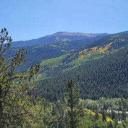
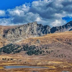
Because we were all itching to see the fall colors and breathe mountain air, I rounded up a small group of us to hit both Kenosha and Boreas Pass. Having experienced Guanella many times in the past, I was ready for a new experience and this one did not disappoint. Let's just say we weren't the only ones with this idea and spent a sweet amount of time in traffic. Once we passed over Kenosha - not only were we stunned at the gorgeous color, but traffic started to dissipate. After turning at Como, we were greeted with most gorgeous colors of gold, yellow, orange and red! However: The terrain is ROUGH. A (2 way) dirt road, winds around the mountain and is embedded with rocks. It's not a 4-wheel drive type situation, but just short of one. We found ourselves a bit nervous throughout the ride, but we handled it like a champ and before we knew it, we were in awe of the colors surrounding us! I highly recommend taking the US 285 way (up the mountain), rather than approaching the pass from Breckenridge - as most of traffic was headed the same direction we were and had the right of way. The pass can get insanely crowded so it takes much longer than expected - so plan accordingly! Expect dust. Expect traffic and frequent stops. Expect to pull over multiple times for photo ops. Expect to be wow'd!

What a gorgeous drive! We started in Breckenridge and made the whole loop drive to Como and back on the highway. We saw the end of fall colors and the first snow the first weekend of October! The road is definitely rocky at times so 4 wheel drive or all wheel drive are best, especially in wet conditions. We made the drive in my Subaru Impreza and made it through fine, but most people seem to have SUVs. We had a pretty empty day on the road and were able to stop whenever we wanted for photo ops and taking in the view. The whole drive to Como takes about an hour.

1 year ago
Do you consider yourself a nature person? If so, I highly recommend the Boreas Pass experience. If not, it might be a really boring drive. As nature lovers, we've done it twice. I can't imagine being in Breckenridge in the fall and not experiencing Boreas Pass. If the aspen trees are turning, there's no better way to spend an afternoon. You can do it as quickly or as leisurely as you like for us. It has taken us about 4 hours. From Breckenridge, in the fall, I wouldn't leave after noon to get started. We love to stop and take pictures and get out and walk a little bit too. We've done it in the fall with the Aspen's turning yellow, and I can't recommend it enough. If you complete the whole drive, you'll experience quite a bit of elevation change. This last time when we were returning to Breckenridge the tire pressure indicator light in the car turned on after we had finished the drive and we're headed back to Breckenridge. There are gas stations with air pumps but they are few and far between. It might be a good idea to stop and put air in your tires in Fairplay, CO before making the drive back to the town you are visiting. (Assuming, here, that locals don't need to read Yelp reviews for Boreas Pass). We ate at Otto's Food Cart in Alma, CO, but then had to head back to FairPlay, CO where the original Otto's restaurant is located to put air in our tires. Next time we might check out Otto's in FairPlay and air up our tires around the corner before heading back to Breck. September 2024 read more


This was a pretty good and basic drive. It has some good views and the road is easily navigable in a fwd vehicle. It threw us out in Como, which didn't really have any food options. There were a lot of people that just made it annoying as they walked in areas of the road without paying attention and people were driving their 4wd pickups like they had cars (several let me pass them in the minivan with 40psi street tires, which was absurd as I wasn't driving fast or anything). read more

3 years ago
I'm a boy from South Louisiana. Most of my life is spent about 20 feet below sea level. But damn, I love the mountains. If you're in the Breckenridge area and it isn't winter, you must drive this pass. I guess must is a strong word so let me just say I strongly recommend you drive this pass. Note: The road is gravel and fairly smooth. It does get a little bumpy past the continental divide. Drive slowly and you will be fine. I made it in an AWD GMC Acadia with no issues. This is a beautiful drive that you must see to believe. I cannot find the words to accurately describe how beautiful the view really is. Check my photos and you will get a an idea of what I mean. The entire drive took me around 4 hours including numerous photo stops. There are a couple of sections where you're white knuckling due to other drivers heading the opposite way. This is not a huge issue so I wouldn't concern myself with it. I think it would be worse heading towards Breck so I'd start in Breck and end on the other side. This review is not my greatest work. I'm writing it in an airport but just take the drive. You won't regret it. read more


Because we were all itching to see the fall colors and breathe mountain air, I rounded up a small group of us to hit both Kenosha and Boreas Pass. Having experienced Guanella many times in the past, I was ready for a new experience and this one did not disappoint. Let's just say we weren't the only ones with this idea and spent a sweet amount of time in traffic. Once we passed over Kenosha - not only were we stunned at the gorgeous color, but traffic started to dissipate. After turning at Como, we were greeted with most gorgeous colors of gold, yellow, orange and red! However: The terrain is ROUGH. A (2 way) dirt road, winds around the mountain and is embedded with rocks. It's not a 4-wheel drive type situation, but just short of one. We found ourselves a bit nervous throughout the ride, but we handled it like a champ and before we knew it, we were in awe of the colors surrounding us! I highly recommend taking the US 285 way (up the mountain), rather than approaching the pass from Breckenridge - as most of traffic was headed the same direction we were and had the right of way. The pass can get insanely crowded so it takes much longer than expected - so plan accordingly! Expect dust. Expect traffic and frequent stops. Expect to pull over multiple times for photo ops. Expect to be wow'd! read more


8 years ago
What a gorgeous drive! We started in Breckenridge and made the whole loop drive to Como and back on the highway. We saw the end of fall colors and the first snow the first weekend of October! The road is definitely rocky at times so 4 wheel drive or all wheel drive are best, especially in wet conditions. We made the drive in my Subaru Impreza and made it through fine, but most people seem to have SUVs. We had a pretty empty day on the road and were able to stop whenever we wanted for photo ops and taking in the view. The whole drive to Como takes about an hour. read more


8 years ago
16 years ago
9 years ago
12 years ago
Beautiful drive especially in the fall. The road is unpaved and very narrow in spots. I recommend an SUV, but a car can make the drive. Great views and lots of places to stop and see the history of this road. Trails for hiking, and a few cabins to rent at the top. read more

More info about Boreas Pass
Ask the Community - Boreas Pass
Review Highlights - Boreas Pass


Boreas Pass - hiking - Updated June 2026
Best of Jefferson
Browse Nearby
Browse Brands
Browse Articles
People who viewed Boreas Pass also viewed
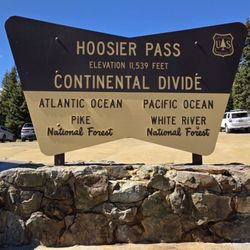
Hoosier Pass
11 reviews
Pika Trail
3 reviews
Blue Lakes Trail Breckenridge
8 reviews
Mayflower Gulch Trail
7 reviews
River Park and Playground
6 reviews
Front Street River Park
2 reviews
The Iowa Hill Trailhead
1 review
Carter Park Dog Park
12 reviews
Rich Creek Trailhead
2 reviews
Sallie Barber Mine Trailhead
1 review