Cancel

    Open app

    Search

    Pika Trail

    4.7 (3 reviews)

    Pika Trail Photos

    You might also consider

    Recommended Reviews - Pika Trail

    Your trust is our priority, so businesses can't pay to alter or remove their reviews. Learn more about reviews.
    Yelp app icon
    Browse more easily on the app
    Review Feed Illustration

    1 year ago

    Helpful 0
    Thanks 0
    Love this 0
    Oh no 0

    3 years ago

    Helpful 8
    Thanks 0
    Love this 7
    Oh no 0

    2 years ago

    Nice short hike with great views. Fairly level and allows dogs on leash. Have to drive through a subdivision to reach trailhead.

    Helpful 0
    Thanks 0
    Love this 0
    Oh no 0

    Verify this business for free

    People searched for Hiking 262 times last month within 15 miles of this business.

    Verify this business

    Rich Creek Trailhead - Rich Creek Trail (5/27/23)

    Rich Creek Trailhead

    4.5(2 reviews)
    6.0 mi

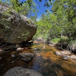
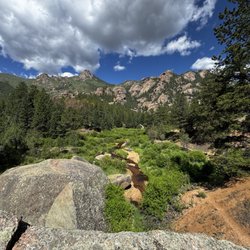
    Rich Creek Trail is a moderate hike in the Buffalo Peak Wilderness near the town of Fairplay. This…read moreparticular trail is on the outskirts of the Weston Pass Campground, with the small trailhead parking lot just prior. A fairly simple out and back trail it may be, however the majority of the trail sits alongside Rich Creek. So for the duration of the hike you hear the wonderful sounds of the rushing creek. Absolutely splendid! With all the rain we've gotten this season, it's no surprise that nature is putting on a show earlier than normal. The abundant evergreens are looking more like summer than mid spring. The vibrant trees definitely added an extra pop of color during the hike and I certainly wasn't complaining. The trail is well marked, and at one point you will have to cross the creek. Be prepared to add some extra wood to the makeshift bridge, because it was on its last leg as I crossed. Tread lightly. I did see some stunning bluebirds during my time out here. Otherwise no major wildlife to be found. 5.5 miles roundtrip. 1,161 ft. elevation gain. 2.5 hours total. For a Memorial Day Weekend hike, I was very content with this trail. I bet this trail is even more beautiful in the Fall. Saw about 9 or 10 people the whole time. Parking lot has 7-8 spots, so if you're going on a Summer weekend it might fill up. Hiking season has begun!

    This review is for the total Buffalo Wilderness Trail....as I am too lazy to create a new Yelp…read morepage. Amazing 11 mile loop with great places to camp along. Fishing, birding, plenty of Wildlife....even spotted a few beavers near a small lake. Sure the unpaved path in will beat up your car...but it is worth it. Highly recommended for an easy 2-3 day backpacking excursion.

    Photos
    Rich Creek Trailhead - Rich Creek Trail (5/27/23)

    Rich Creek Trail (5/27/23)

    Rich Creek Trailhead - Rich Creek Trail (5/27/23)

    Rich Creek Trail (5/27/23)

    Rich Creek Trailhead - Rich Creek Trail (5/27/23)

    See all

    Rich Creek Trail (5/27/23)

    Goose Creek Trail in Lost Creek Wilderness

    Goose Creek Trail in Lost Creek Wilderness

    4.8(4 reviews)
    39.6 mi

    It's a tough thing to be from CO and recommend great trails. Coloradans naturally want to gatekeep…read morebeautiful secrets, but had to write a review for this incredible hiking trail (which I'm sure isn't really a secret). Took my 12 year old daughter backpacking on this trail and we had a fantastic time. There are plenty of areas to set up a tent along the creek for the first 2 miles. After that the elevation climbs and you have to wait until 4 miles or so and you aren't as close to water. There were hardly any mosquitos, but a lot of flies. The flies were relentless, and only one type seemed to bite. Some bug spray helped a little. The scenery was beautiful. Greener than a lot of spots in CO due to the creek and massive boulders everywhere. There's a lot of bird activity including humming birds. There wasn't a ton of foot traffic either. The trail is narrow but maintained. I do not suggest going on the unmaintained trail on the other side of the creek. We hiked the maintained trail in and the unmaintained trail out and there were several spots that were difficult with a 40 lb backpack on due to loose dirt and gravel. Just stay on the main trail especially if you have kids packing in. The water level was pretty low in some areas and the only fish we saw in our spot were tiny ones, so it's probably not great for anglers. The road leading there is a long dirt road and goes down to a single lane in some spots so take it slow. One driver was being very irresponsible and driving as fast as possible and taking turns quickly so as to spin out and nearly hit us! You can't see around curves and there are steep drop offs, so please drive cautiously. There's no cell service out there (AT&T), so remember the turns you made driving and landmarks like campgrounds and ranches. Beautiful spot. Would recommend.

    I did this as part of a larger loop last weekend. The trail conditions for this segment were really…read moregood. It's a long trail, but not too difficult for a reasonably in shape person. Usually, you can walk two abreast and the river crossings are not hard. Lots of nice campsites every mile or so, visible right next to the trail. Once you get away from the trailhead, firewood is plentiful. Some camp sites are right next to water, so you can filter it and you're good. Others, you may have to carry water there. We did have some wet weather, which wasn't bad if you have good raincoats. Naturally, if you go to higher elevations, the rain comes down as snow, or hail, even in June. If you're just doing Goose Creek, within the first 7-8 miles, it's super easy to follow. However, good maps are available for free from the USGS web site. We also had a good map for Lost Creek from Amazon. Not too hard to get to the trail head, although you do have to drive about 15 miles of windy dirt road. It takes about 45 minutes for that part, especially if you have to back up to let someone go the other way on one of the single lane parts.

    Photos
    Goose Creek Trail in Lost Creek Wilderness
    Goose Creek Trail in Lost Creek Wilderness
    Goose Creek Trail in Lost Creek Wilderness

    See all

    Mount Massive

    Mount Massive

    4.7(7 reviews)
    10.5 mi

    Arrived at 5:40 am. Only a handful of cars in the parking lot. Lot is not very big. There is no…read morebathrooms in the lot and also no trashcans. If you need to go to bathroom pop over to elbert or one of the bathrooms along the road/way to get to the trailhead. Otherwise be sure to plan on packing out what you pack in. Trail is actually 14.5 miles per 14ers.com. So be prepared that this is longer than what all trails states. This is the standard route for this peak. This trail is well maintained and in good shape. Trail is currently in summer conditions. Basically this is just a REALLY LONG trail with a lot of elevation gain. There is nothing technical about it. When you get to the ridge there is still a pretty well defined trail. You will have to step over some rocks but nothing bad. The inclining meadow leading up to the ridge though seems to go on forever! Bring plenty of water, food, O2, and be prepared. If you are bringing your dogs. Pack out their poop bags! Also keep them on a leash! Saw pica, marmots and some birds i had not seen before. No goats though. I did this in 6 hours total hiking time but was moving at a fairly fast clip.

    Okay I do dumb things sometimes…read more.. Welp trying to hike Massive in the winter ranks high up there. We started at the Leadville Hatchery and the weather looked gorgeous...and then it didn't, Lack of any trail made matters shall we say a tad more difficult. Did not summit but did not die...win win??? Will do in the summer when sanity will prevail.

    Photos
    Mount Massive
    Mount Massive
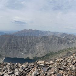
    Mount Massive

    See all

    Pika Trail - hiking - Updated July 2026

    Loading...
    Loading...
    Loading...