Bear Peak Trail Photos


You might also consider
More like Bear Peak Trail
Recommended Reviews - Bear Peak Trail
Start your review...

Reviews With Photos

This is quite the beautiful trail right on Boulder's doorstep! When you're a bit tired of the same old nearby, head up the the NCAR lab and score some free parking in the huge lot. Finding the Bear Peak Trail is a bit tricky, but if you stick left and generally climb, you will cross around 2 miles of pretty pine forest with views all around. The trail has a few options including road. After an hour or so, you reach the Fern Canyon Trail. This rocky road is a straight shot up to a saddle ridge. The trail could use some repairs and is eroding badly. It was a bit hard to navigate the slippery slopes. Reaching the col was a nice feeling with some views to the west. From here, you follow a climbers trail left up the ridge line. There's some scrambling a few miles in, after a brief talus field. The climbing looks worse then it is, but definitely keep your footing and be careful. Wouldn't take dogs here. Reaching the summit is a great feeling and there's a bit of room to relax. Next time I'm heading over to South Boulder! You can find more on All Trails.

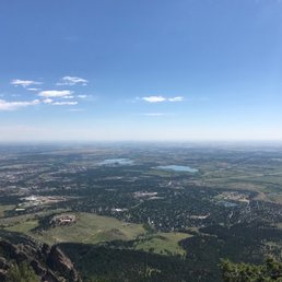

After 30 years living in Colorado I finally made it to this awesome trail and peak. We parked at the Eldorado trailhead and made the trek up the mountain. It's not a 14er, but the hike is pretty technical for recreational hikers. Don't let that hold you back, but it helps to be in good shape to make the trip up. We actually hiked South Boulder Peak first, and then took the saddle trail to Bear Peak, and then down the other side and back to the trailhead. We hiked just over 10 miles in about 5 hours. We hiked through the forest on the way up until we got to a significant burn scar, which was in stark contrast to the nice forest trail. The views from these peaks are incredible - you have a 360 degree view of the front range, local canyons, and the high peaks to the west. As always in Colorado, summit early and get down before the summer storms roll through. The trails are incredibly well marked and maintained, and they do get heavy use. There are other trailheads that can get you to Bear Peak, and the Boulder Mountain Trails network is extensive. This is a great destination for locals and visitors alike (it would be a good idea to acclimate before trying this if you are not used to the elevation). Easy access to Denver/Boulder, and comparable, if not better, than a lot of hikes farther west into the mountains.

How to be the nervous Dad in "Nemo" in a few easy lessons: 1. Allow your 10 year-old son to convince you that making him wear hiking boots is old school, and instead that wearing sneakers with far less "gription" on a hike to the highest point in Boulder County is just fine, (which it basically was, by the way; he had no problems. I had the problems, and honestly can't say he would have been far safer in his hiking boots, since there is nothing very risky about the Bear Peak trail. And it didn't help any there were teen girls all over the trail wearing sneakers. "Dad, see? See what I mean?" 2. Ascend to the Bear Peak Summit via Fern Canyon, which I knew in advance is the steepest, most difficult path to the summit. As reviewer Erin S. said of this hike: "Very, very difficult hike. I didn't really know what I was getting into beforehand and it totally kicked my ass." Well, I knew it would kick my ass, and I am in shape. But hey, my companion is a 10 year-old who was thrilled to be back on the front range and was eager to show me he can burn my ass, even if he has been at sea level for the last 10 months. 3. Arrive at the summit pretty darn tired, and watch said energy-oozing 10 year-old scamper up the final and steepest point on the summit, which is a collection of pretty vertical, jagged rocks that indeed make an awesome but - from a nervous Dad's perspective - quite narrow perch for the proud kid showing up his Dad. Here are the narrow, jagged summit rocks I am talking about: http://www.yelp.com/biz_photos/9LBIE5aHCTJVucwlcxQMUw?userid=TtwhWwNSqDv64M2EnYZE8g 4. Accede to gloating 10 year-old's demands to take triumph photos after climbing those damn jagged, vertical rocks, which for me were doubly hard to navigate because for the first time in my life, I got a good dose of Acrophobia. Gad damn it! My stomach was in my throat when I looked down, and here I am, the vanquished Dad: http://www.yelp.com/biz_photos/9LBIE5aHCTJVucwlcxQMUw?select=cChABHGQsLH1MAip_D17Fw After the hike, the kid says: "Dad, I can wear my hiking boots from now; it's okay. Can we climb the second Flatiron tomorrow?" Melt.

5 stars for butt kicking good time! I got this hike from my front range loop hike book, actually it was in my dog hike book, as well as my front range hiking book. Note: THIS IS NOT A GOOD HIKE FOR DOGS. (unless you go very early, and do not do it as a loop and head back the way you cam vs down the Fern trail which is giant boulder stairs, some shard and hot) It is definitely a long hike, and an amazing hike. I did it this year 2013 and the remnants of the previous summer's fire were still there, but there was also some beautiful new growth! Most of the up of the hike - over 4 miles of it is pretty pleasant and doable - lots of switch backs, a good amount of shade, but on a 90 degree day - it's still gonna be hot - so bring a ton of water! The top of the hike turns into a rock scramble. As in - no trail, hold on to rocks and crawl over them to get to the top. The views are amazing and having lunch in the breeze is sooo great! It took all day - we started at 9am and finished around 3 with about 30 minutes at the top! It felt GREAT to accomplish this hike! Been on my to-do list for a while now!

Absolutely gorgeous view at the top of Boulder, Flatirons, western mountains, Eldorado Springs. A bit of a longer hike than expected because the trail is moderately steep with lots of uneven and unstable rocks. We started off with Devil's Thumb as our goal destination so we started at the Shanahan Ridge Trailhead on Table Mesa. This trail has less foot traffic so we enjoyed the initial hike of solitude in the "woods". It merged with the Mesa Trail about 2 miles in then took the same amount of time to reach Bear Peak (about 1.5 more miles). Looped back. A 6-7 mile hike took about 7 hours. For some odd reason, there are a lot of flies near the top of the peak which grossed me out because I wanted a nice quiet retreat up top to enjoy my peanut butter sandwich but instead was bombarded by buzzing noises all around and ungraceful whacking motions which may have caused a few slips here and there. Glad I didn't fall off the cliff. Can someone please explain why these flies reside on top of the mountain?

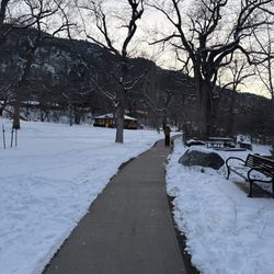
This trail is pretty awesome and scenic. WORD OF ADVICE: Please be prepared if hiking in the winter because the trail was super snowy and slippery in some areas and I probably busted my shit at least 10 times back and forth. Aside from the heart-stopping falls, the hike was easy except the last .5 mile; steep incline of rocks was challenging. The summit is breathtaking and totally worth it!

We saw a couple of snakes and got some great views. The trail network can be hard to follow, as we did make a couple of incorrect turns, but it's because the trails aren't labeled with different colors or different symbols and a few parts could use some additional markers. The atmospheric research center is good to park at and has bathrooms. The trails were well manicured. read more


Probably one of favorite hike in the Denver Boulder region. It is a great test of endurance and agility. My go to is start from NCAR start which is roughly 8.1 miles. You will enjoy fern gulch...lol. Have fun and be safe a good friend went to fast a few days ago and broke their ankle...so chill read more


4 years ago
This is quite the beautiful trail right on Boulder's doorstep! When you're a bit tired of the same old nearby, head up the the NCAR lab and score some free parking in the huge lot. Finding the Bear Peak Trail is a bit tricky, but if you stick left and generally climb, you will cross around 2 miles of pretty pine forest with views all around. The trail has a few options including road. After an hour or so, you reach the Fern Canyon Trail. This rocky road is a straight shot up to a saddle ridge. The trail could use some repairs and is eroding badly. It was a bit hard to navigate the slippery slopes. Reaching the col was a nice feeling with some views to the west. From here, you follow a climbers trail left up the ridge line. There's some scrambling a few miles in, after a brief talus field. The climbing looks worse then it is, but definitely keep your footing and be careful. Wouldn't take dogs here. Reaching the summit is a great feeling and there's a bit of room to relax. Next time I'm heading over to South Boulder! You can find more on All Trails. read more


4 years ago
Visited this trail on a September morning and it was challenging yet fun! I enjoyed all the wonderful views! Beautiful wildflowers, trees, and Boulder! Easy to get to and there are several other trails along the way! A great area to explore all of them and not get bored! read more


Bear Peak Trail is challenging but absolutely worth it!! The trail is well maintained and the views at the top are amazing! Bring extra water and snacks it's a tough hike. Especially when it starts to get hot by noon. Absolutely worth it to go to the top! read more


4 years ago
After 30 years living in Colorado I finally made it to this awesome trail and peak. We parked at the Eldorado trailhead and made the trek up the mountain. It's not a 14er, but the hike is pretty technical for recreational hikers. Don't let that hold you back, but it helps to be in good shape to make the trip up. We actually hiked South Boulder Peak first, and then took the saddle trail to Bear Peak, and then down the other side and back to the trailhead. We hiked just over 10 miles in about 5 hours. We hiked through the forest on the way up until we got to a significant burn scar, which was in stark contrast to the nice forest trail. The views from these peaks are incredible - you have a 360 degree view of the front range, local canyons, and the high peaks to the west. As always in Colorado, summit early and get down before the summer storms roll through. The trails are incredibly well marked and maintained, and they do get heavy use. There are other trailheads that can get you to Bear Peak, and the Boulder Mountain Trails network is extensive. This is a great destination for locals and visitors alike (it would be a good idea to acclimate before trying this if you are not used to the elevation). Easy access to Denver/Boulder, and comparable, if not better, than a lot of hikes farther west into the mountains. read more


15 years ago
How to be the nervous Dad in "Nemo" in a few easy lessons: 1. Allow your 10 year-old son to convince you that making him wear hiking boots is old school, and instead that wearing sneakers with far less "gription" on a hike to the highest point in Boulder County is just fine, (which it basically was, by the way; he had no problems. I had the problems, and honestly can't say he would have been far safer in his hiking boots, since there is nothing very risky about the Bear Peak trail. And it didn't help any there were teen girls all over the trail wearing sneakers. "Dad, see? See what I mean?" 2. Ascend to the Bear Peak Summit via Fern Canyon, which I knew in advance is the steepest, most difficult path to the summit. As reviewer Erin S. said of this hike: "Very, very difficult hike. I didn't really know what I was getting into beforehand and it totally kicked my ass." Well, I knew it would kick my ass, and I am in shape. But hey, my companion is a 10 year-old who was thrilled to be back on the front range and was eager to show me he can burn my ass, even if he has been at sea level for the last 10 months. 3. Arrive at the summit pretty darn tired, and watch said energy-oozing 10 year-old scamper up the final and steepest point on the summit, which is a collection of pretty vertical, jagged rocks that indeed make an awesome but - from a nervous Dad's perspective - quite narrow perch for the proud kid showing up his Dad. Here are the narrow, jagged summit rocks I am talking about: http://www.yelp.com/biz_photos/9LBIE5aHCTJVucwlcxQMUw?userid=TtwhWwNSqDv64M2EnYZE8g 4. Accede to gloating 10 year-old's demands to take triumph photos after climbing those damn jagged, vertical rocks, which for me were doubly hard to navigate because for the first time in my life, I got a good dose of Acrophobia. Gad damn it! My stomach was in my throat when I looked down, and here I am, the vanquished Dad: http://www.yelp.com/biz_photos/9LBIE5aHCTJVucwlcxQMUw?select=cChABHGQsLH1MAip_D17Fw After the hike, the kid says: "Dad, I can wear my hiking boots from now; it's okay. Can we climb the second Flatiron tomorrow?" Melt. read more


5 stars for butt kicking good time! I got this hike from my front range loop hike book, actually it was in my dog hike book, as well as my front range hiking book. Note: THIS IS NOT A GOOD HIKE FOR DOGS. (unless you go very early, and do not do it as a loop and head back the way you cam vs down the Fern trail which is giant boulder stairs, some shard and hot) It is definitely a long hike, and an amazing hike. I did it this year 2013 and the remnants of the previous summer's fire were still there, but there was also some beautiful new growth! Most of the up of the hike - over 4 miles of it is pretty pleasant and doable - lots of switch backs, a good amount of shade, but on a 90 degree day - it's still gonna be hot - so bring a ton of water! The top of the hike turns into a rock scramble. As in - no trail, hold on to rocks and crawl over them to get to the top. The views are amazing and having lunch in the breeze is sooo great! It took all day - we started at 9am and finished around 3 with about 30 minutes at the top! It felt GREAT to accomplish this hike! Been on my to-do list for a while now! read more


Absolutely gorgeous view at the top of Boulder, Flatirons, western mountains, Eldorado Springs. A bit of a longer hike than expected because the trail is moderately steep with lots of uneven and unstable rocks. We started off with Devil's Thumb as our goal destination so we started at the Shanahan Ridge Trailhead on Table Mesa. This trail has less foot traffic so we enjoyed the initial hike of solitude in the "woods". It merged with the Mesa Trail about 2 miles in then took the same amount of time to reach Bear Peak (about 1.5 more miles). Looped back. A 6-7 mile hike took about 7 hours. For some odd reason, there are a lot of flies near the top of the peak which grossed me out because I wanted a nice quiet retreat up top to enjoy my peanut butter sandwich but instead was bombarded by buzzing noises all around and ungraceful whacking motions which may have caused a few slips here and there. Glad I didn't fall off the cliff. Can someone please explain why these flies reside on top of the mountain? read more


8 years ago
This trail is pretty awesome and scenic. WORD OF ADVICE: Please be prepared if hiking in the winter because the trail was super snowy and slippery in some areas and I probably busted my shit at least 10 times back and forth. Aside from the heart-stopping falls, the hike was easy except the last .5 mile; steep incline of rocks was challenging. The summit is breathtaking and totally worth it! read more


17 years ago
14 years ago
19 years ago
16 years ago
16 years ago
We liked this trail a lot. We started late in the day and we had a choice to select a shorter trail or lengthy trail. We completed Royal Arch and 2cnd and 3rd Flatiron points. Some of the points have ice and we found a bit adventurous to cross them. This is a memorable trip and definitely worth trying it. read more


8 years ago
12 years ago
15 years ago
18 years ago
14 years ago
More info about Bear Peak Trail
Ask the Community - Bear Peak Trail
Review Highlights - Bear Peak Trail
You might also consider


Why does Yelp recommend reviews?
Bear Peak Trail - parks - Updated June 2026
Best of Boulder
People found Bear Peak Trail by searching for…
Trending Searches in Boulder, CO
Amusement Parks near Bear Peak Trail
Baseball Fields near Bear Peak Trail
Black Owned Nail Salons near Bear Peak Trail
Boardwalk near Bear Peak Trail
Boat Rental near Bear Peak Trail
Cliff Jumping near Bear Peak Trail
Dog Friendly Beaches near Bear Peak Trail
Fishing Spots near Bear Peak Trail
Free Kids Activities near Bear Peak Trail
Free Things To Do With Kids near Bear Peak Trail
Jet Ski Rental near Bear Peak Trail
Kids Activities Outdoor near Bear Peak Trail
Outdoor Basketball Courts near Bear Peak Trail
Parks With Pull Up Bars near Bear Peak Trail
Pick Your Own Farms near Bear Peak Trail
Playgrounds near Bear Peak Trail
Soccer Store near Bear Peak Trail
Splash Pad near Bear Peak Trail
Strawberry Picking near Bear Peak Trail
Swimming Holes near Bear Peak Trail
Swimming Lakes near Bear Peak Trail
Swimming Pools near Bear Peak Trail
View Fireworks near Bear Peak Trail
Browse Articles
Browse Nearby
Browse Brands
Related Searches in Boulder, CO
Best Nature Trails for Hiking in Boulder, Colorado
Best Off Leash Dog Parks in Boulder, Colorado
Best Parks for Parties and Events in Boulder, Colorado
Best Water Parks for Kids in Boulder, Colorado
Check Out Great Playgrounds in Boulder, Colorado
Discover Baseball Fields Around Boulder, Colorado
Discover Beautiful Garden Spots in Boulder, Colorado
Discover Free Parking Options in Boulder, Colorado
Discover Fun Toddler Parks in Boulder, Colorado for Your Little One
Discover Lakes & Ponds to Explore in Boulder, Colorado
Discover Popular Photo Spots in Boulder, Colorado
Discover Scenic Bike Paths in Boulder, Colorado
Discover Soccer Fields in Boulder, Colorado Near You
Discover Top Nature Parks to Visit in Boulder, Colorado
Discover Top State Parks to Visit in Boulder, Colorado
Discover the Best Beaches in Boulder, Colorado
Discover the Best Kids Park Spots in Boulder, Colorado
Enjoy the Best Picnic Spots and Ideas in Boulder, Colorado
Enjoy the Best Walking Trails in Boulder, Colorado
Explore Beautiful Botanical Gardens in Boulder, Colorado
Explore Easy Hikes Perfect for All in Boulder, Colorado
Explore Family-Friendly Zoos and Wildlife in Boulder, Colorado
Explore Free Picnic Areas Around Boulder, Colorado
Explore Fun Activities to Do in Boulder, Colorado
Explore Parks With Pull Up Bars in Boulder, Colorado
Explore Popular Campgrounds Near Boulder, Colorado
Explore Popular Picnic Areas Around Boulder, Colorado
Explore Popular RV Parks Around Boulder, Colorado
Explore Popular Recreation Centers Around Boulder, Colorado
Explore Scenic Lakes to Visit in Boulder, Colorado
Explore Top Dog Parks in Boulder, Colorado Near You
Explore Top Water Parks in Boulder, Colorado Today
Explore the Best Trail Options in Boulder, Colorado
Find Parks and Recreation Activities in Boulder, Colorado
Find Top Dog Friendly Parks to Visit in Boulder, Colorado
Find Top Skate Parks in Boulder, Colorado for All Skill Levels
Find a Park With BBQ Pits in Boulder, Colorado
Find the Best Parks BBQ Grills in Boulder, Colorado
Find the Best Swimming Pools in Boulder, Colorado Today
Have Fun at a Splash Pad in Boulder, Colorado
Locate Tennis Courts Around Boulder, Colorado
Parks With Basketball Courts for Games in Boulder, Colorado
Play at a Splash Pad Park in Boulder, Colorado
Popular Outdoor Activities to Try in Boulder, Colorado
Top Hiking Trails to Explore in Boulder, Colorado
Top Places to Visit in Boulder, Colorado for Sightseeing
Top Running Trails to Explore in Boulder, Colorado
Top Swimming Lakes to Enjoy in Boulder, Colorado
People who viewed Bear Peak Trail also viewed
First Flatiron
10 reviews
Diamond Lake Trail
9 reviews
Gregory Canyon
6 reviews
Mallory Cave Trail - NCAR Mesa Trail
10 reviews
Clear Creek Canyon Big Easy Trailhead
12 reviews
Hessie Trailhead
21 reviews
Clear Creek Trail & Water Park
10 reviews
Forest Lakes
1 review
White Ranch Open Space Park
26 reviews
Arapaho Lakes Trail
1 review