Mt. Evans Wilderness Photos


You might also consider
More like Mt. Evans Wilderness
Recommended Reviews - Mt. Evans Wilderness
Start your review...

Reviews With Photos
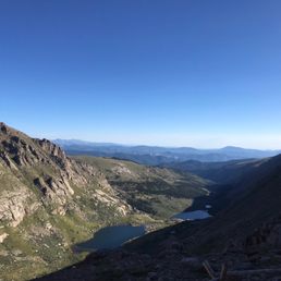
Had a great and challenging hike up Mount Evans. Don't be fooled by the not as challenging hike up to the summit of Mount Spalding a neighboring 13er. Once when you make your summit up to Mount Evans it's very difficult. The path is just a rocky side of the mountain that you find your own path up. It's steep, rocky, and feels like a really long way up to the top. Once when you make it up rocky wall, you will summit Mount Evans up a small ascent with all of the people who drove up the pass. It's crowded but worth it and the hike is beautiful. We walked down the road since the weather was starting to storm and we didn't want to be caught in a storm on the way down.

We arrived September 1st to Colorado for the first time. We read the Mount Evans closed some of the roads on Labor Day which will be the very next day. So as soon as we got a rental car we headed to Mount Evans. We did stop at Echo Lake and take some pics and look around before we headed to the mountain was very pretty ... nice place to walk . Arrived at Mount Evans decided to buy a national park pass so it looks like we're going to try to visit several national parks in the next 12 months . We did a bit of reading about the Mount Evans before coming ... read that the driving up the mountain would kind of scary with no guard rails and being at such an elevation. Not our first time doing big mountains my husband did the driving as I did the pictures. This is the first time I had any trouble with elevation sickness though it really kicked my ass. I couldn't breathe well I had a headache I couldn't think I just did not feel well but the scenery was so beautiful it was still worth doing and very enjoyable. We saw mountain goats and marmots. There are some lakes and just one beautiful scene after the other love love this beautiful scenery. I do have asthma and have recently been diagnosed with a rapid heartbeat. I don't know if that's why I had trouble with elevation. Luckily I had a Nebulizer breathing machine in the car that really helped me not die. But it really had to manage our expectations for walking. I really wasn't able to walk very much up there. Probably wasn't the best place to head straight from the airport.

SO MAGICAL. Ok, so imagine yourself driving on a road then all of the sudden you day "I wonder where that road goes?". That's exactly what Berry and I did. Somehow we were driving up Mt. Evans and it was truly an awesome site. The snow was falling gently onto the ground and the trees lightly dusted with frost. This is a place I will never forget. The mountain at its peak is 14K feet and you definitely feel the altitude while driving. Oh and the drive itself was breathtaking. Around every scary, icy turn there was a majestic view for the taking. I never thought I would have used the word majestic LOL. I was expecting to see animals singing and talking due to the fact it was so magical. Ok, I need to focus. I strongly encourage you to visit this place as soon as possible, you will not regret it. *DISCLIMER: The actual driving on the mountain is challenging, use extreme caution.

The best!! Top of the world and so beautiful. No view compares. Timed entry and reservations needed to go all the way to the top. Echo Lake and Summit Lake are breathtaking. We saw mountain goats and mountain sheep. This trip was an awesome experiences. Near the top, there a trees bent by the wind and hundreds of years-old. There are bathrooms along the way. Parking is crowded. We will be back again and again.

According to AllTrails, the Mount Evans and Mount Spalding Loop Trail is "a 4 mile heavily trafficked loop trail located near Idaho Springs, Colorado that features a lake and is rated as difficult." DIFFICULT INDEED. I recently visited Denver for the first time and had a blast. Denver's surrounding nature (aka the Rocky Mountain Range) is absolutely beautiful, especially on a clear October weekend. I landed on a Friday night at 9pm, and then woke up 6 hours later so we could drive 2 hours to Summit Lake on Mount Evans to begin the hike: my first ever 14er (14,000 ft. elevation hike). The roads to Summit Lake twist and turn, and there aren't guardrails around a lot of the turns, so I recommend driving very carefully, especially if it's at 5am in the dark. There's a parking lot at Summit Lake that charges $5 (honor system) that has 2 gender neutral bathrooms. The road that leads up to the top of Mount Evans is closed after labor day to account for weather conditions, so the Summit Lake parking lot is the furthest you can go after labor day. Okay, now on to the actual hike. After arriving at the Summit Lake parking lot around 5:30am, my friend and I waited for her coworkers to arrive. It was pitch dark, 25 degrees, and the wind was already blowing violently at, I want to guess, 30mph. Fast enough to slam car doors shut and blow me slightly off my walking path. The 8 of us set out to do the trail going counter-clockwise, and 20 minutes in, 3 people decided to head back either from altitude sickness or it being just too cold. I had been worried about coming from Austin to Denver and hiking a 14er with only 9 hours to adjust to the elevation difference, but I took a non-drowsy dramamine and didn't feel any altitude sickness. The 5 of us trudged on with our backpacks and flashlights, taking frequent breaks to catch our breath since the rocky trail was decently steep and and the air was so thin at that elevation. However, our breaks had to be short because our fingers and toes felt like they started to freeze if we weren't moving and generating body heat. After 3.5 hours, we finally got to the parking lot near the top of the mountain, hiked the last 20 minute stretch among the rocky switchbacks, and reached the top. Wow... Usually, I like challenging hikes that offer a great view because I can take my time up at the top, eat lunch, and enjoy the view I worked hard for. But at the Mt. Evans peak, the wind was still furiously blowing into us, so we snapped a quick group picture and made our way down the mountain as fast as possible. Ultimately, it took about 5 hours for us to complete the 4-mile hike, and boy was I tired. I did feel incredibly accomplished for having completed a 14er though, especially since it was only 11am by the time we were done. Final Rating: This type of nature, the moutains, the water, the hills and valleys, is a guaranteed 5. However, I think the Mt. Evans and Mount Spalding loop trail is more of an achievement hike than it is a viewpoint hike. Yes, the 360 degree views of the mountain ranges are cool, but the best view was watching the sunrise paint the sky and illuminate Summit Lake at 6:30am in the morning. The rest of the hike was more about surviving the winds, accomplishing a 14er, and making it back safely.

This was one of my favorite intermediate level hikes to the very top!! Aside from it raining down below on the foothills of the mountain, we were greeted by chunks of snow and also hills that looked beautiful as the sun hit the light right. From afar, the views are also ravishing, looked like a live painting with glows from the heavens. We absolutely enjoyed the charm of mother nature that day. We had no trouble with the crowds and had the trail to ourselves for the most part. We hiked for a total of 4-6 hours and also took breaks here and there. We had come prepared and brought snacks and drinks to keep us hydrated and had deep talks on the hills of this gorgeous place. The Peak of Mt. Evans became an inspirational for us to drive up next time and proclaim Mt. Evans, as one of our proudest hikes. Solely, enjoying God's works through nature. At the view that we had, we found that there indeed is a lake where the mountain is shaped like a Halo! Unfortunately, we did not get to see any mountain goats ... Yet, however this will be a great park to revisit. Mt. Evans is one of the tallest mountains in CO, and that makes me smile, knowing we did hike to the very top back in July of 2019. Mt Evans has a scenic bypass, connected to an iconic phoenix gold mine, which is advertised on a map visiting Mt. Evans.

If you are wanting views, this is the place! The drive up Mt Evans is not for the faint of heart. It's a sweaty palms type of drive. I definitely caution anyone driving it to be 100% focused on driving and forget the views until you get to the top. This is not for novice drivers. The road is very narrow, with tight blind hairpin turns and it's a little crumbly. That said, it's got the views and the notch in your belt that you were up on a fourteener. (Although you drive it.) I believe you can hike it from Summit Lake but we were so focused on driving we didn't notice if there was a way to actually hike it.

We went to Mt Evan's July 2017 while visiting relatives in Evergreen. What a beautiful place. We threw snowballs in July. We never did that. The road it tight and alot of turns, so speeding does you no good nor does tailgating.l believe there are 14 miles of winding road. There is a fee to enter. I am not sure of the cost. This is the highest elevation of a paved road in the United States. I recommend going to Mt Evan's.


My husband and I drove to and from the summit on our wedding anniversary. We hadn't taken this drive for 13 years. The road is scary but adds to the adventure of this journey to the summit of Mt. Evans. We really enjoyed the Mount Goliath Natural Area with its beautiful wildflowers, an example of a Rocky Mountain Bristlecone pine tree over 1,000 years old and a nice little stream. On the summit we encountered a big family of mountain goats and were able to take close up photos and movies of them, They are magnificent animals. We even saw a marmot! The remains of the Crest Stone House are always fascinating as is the history behind it, You will not regret your drive up and down Mt. Evans. It is literally entering a world above the skies where you can even see hawks flying below you. It is exhilarating.

The roads are kind of scary (no guard rails and scary turns) but as long as you drive slow you'll be fine. The scenic drive made it all worth it. They were views I couldn't capture in photos, you just have to be there to experience the beauty of it. I was also so happy to see so many adorable animals! The mountain goats were everything.


Experienced the scenic byway, it wasn't more than a 2 hour full circle loop. I found that the northern part of the 103 loop is not nearly as scenic as the lower loop. If you want to try to access Mount Evans at this time of year (November) you cannot as the road is closed beyond Echo Lake for the winter. I knew this in advance. I was blown by the overlooks and was curious given the raving reviews. I would say that at this time of the year it's worth the drive, however, it's much better in the summer. https://www.tripadvisor.com/ShowUserReviews-g33388-d145862-r435161607-Mount_Evans-Denver_Colorado.html#

A friend of mine had told me about this place and said we should give it a visit when in Colorado. We tried to do that the last time we were there, but it had already closed for the season. This trip, we were a week or so earlier, so we decided to try again. Fortunately, most of the area was still open. Only the very top was closed. Timed entry passes are required here, just like in many of the National Parks. I'm glad one of our group thought to get it. After a very nice drive up from Idaho Springs, we showed our permit and headed up. Part of the fun of this trip is that it's the highest paved road in North America (14,264 ft). We made it all the way up to one of the alpine lakes, and it was cold. I'm glad we were prepared for the cold and wind. We didn't see any wildlife at the lake, but we did see some on the way up. The area is full of deer, big horn sheep, and mountain goats, and we got to see 2 of the 3. Will I return? Definitely. However, if you want to see it all, you better go in the summer. read more


5 years ago
Beautiful. Loved this hike. Come early. parking lot may fill up. We arrive at 6 am on monday 6/27/2021. summit lake lot was around half full. There are bathrooms available at the lot for use. Bring $5 cash to pay to park when you arrive. there is an envelope to fill out over near the bathroom for parking. Take the trail that doesn't go down close to the lake and then you will hang a left. There is some signage before you really start to incline. the elevation gain from the parking lot to mount spaulding was fairly intense. There are a lot of rocks. Would make sure you have good boots for this hike. Once you get up to mount spaulding you will start to DESCEND. the trail up to mount spaulding is relatively well laid out. however after you get down from mount spaulding. Well there is a rock area that is not marked at all. Take a peek at 14ers.com so you can see some pics of where you should go. once you get over the hump and down. Stay around 25 feet down below the ridge and look for the CAIRNS. Rock piles. These will help guide you to where you should be going. Thankfully all trails did pull up for me when we were in the spot that is absolutely not marked. just be prepared for that stretch. From spaulding on up to the summit was a lot of climbing around on rocks. It was fun but be prepared for that. There were not many folks on the actual trail. but once you hit the summit parking lot at the top there will be a fair amount of people up at the summit as a lot of people drive up there. They do have bathrooms at the top, that is actually kind of a nice treat. I really enjoyed this 14er. I would definitely be up for doing this one again. read more


4 years ago
This was tougher than I thought it would be. You read all the information on what happens when you climb higher. Well to provide an example, at the bottom it was 82 degrees. We got to the top and temperature dropped down to 38 degrees. I didn't have the correct clothes on for being that high up on Mt. Evans. The other part is when I got out of the vehicle, wow the air took my breath away and took me a while to gain it back. I got lightheaded immediately while exiting the vehicle. Besides that the views were absolutely amazing. Some of the best views I've ever seen. It reminded me of Washington State and South Dakota. Just incredible views. The other part was driving to the top, guardrails are minor and gets more scary as you drive further up. It was a great time. read more


Had a great and challenging hike up Mount Evans. Don't be fooled by the not as challenging hike up to the summit of Mount Spalding a neighboring 13er. Once when you make your summit up to Mount Evans it's very difficult. The path is just a rocky side of the mountain that you find your own path up. It's steep, rocky, and feels like a really long way up to the top. Once when you make it up rocky wall, you will summit Mount Evans up a small ascent with all of the people who drove up the pass. It's crowded but worth it and the hike is beautiful. We walked down the road since the weather was starting to storm and we didn't want to be caught in a storm on the way down. read more


We arrived September 1st to Colorado for the first time. We read the Mount Evans closed some of the roads on Labor Day which will be the very next day. So as soon as we got a rental car we headed to Mount Evans. We did stop at Echo Lake and take some pics and look around before we headed to the mountain was very pretty ... nice place to walk . Arrived at Mount Evans decided to buy a national park pass so it looks like we're going to try to visit several national parks in the next 12 months . We did a bit of reading about the Mount Evans before coming ... read that the driving up the mountain would kind of scary with no guard rails and being at such an elevation. Not our first time doing big mountains my husband did the driving as I did the pictures. This is the first time I had any trouble with elevation sickness though it really kicked my ass. I couldn't breathe well I had a headache I couldn't think I just did not feel well but the scenery was so beautiful it was still worth doing and very enjoyable. We saw mountain goats and marmots. There are some lakes and just one beautiful scene after the other love love this beautiful scenery. I do have asthma and have recently been diagnosed with a rapid heartbeat. I don't know if that's why I had trouble with elevation. Luckily I had a Nebulizer breathing machine in the car that really helped me not die. But it really had to manage our expectations for walking. I really wasn't able to walk very much up there. Probably wasn't the best place to head straight from the airport. read more


7 years ago
SO MAGICAL. Ok, so imagine yourself driving on a road then all of the sudden you day "I wonder where that road goes?". That's exactly what Berry and I did. Somehow we were driving up Mt. Evans and it was truly an awesome site. The snow was falling gently onto the ground and the trees lightly dusted with frost. This is a place I will never forget. The mountain at its peak is 14K feet and you definitely feel the altitude while driving. Oh and the drive itself was breathtaking. Around every scary, icy turn there was a majestic view for the taking. I never thought I would have used the word majestic LOL. I was expecting to see animals singing and talking due to the fact it was so magical. Ok, I need to focus. I strongly encourage you to visit this place as soon as possible, you will not regret it. *DISCLIMER: The actual driving on the mountain is challenging, use extreme caution. read more


4 years ago
5 years ago
The best!! Top of the world and so beautiful. No view compares. Timed entry and reservations needed to go all the way to the top. Echo Lake and Summit Lake are breathtaking. We saw mountain goats and mountain sheep. This trip was an awesome experiences. Near the top, there a trees bent by the wind and hundreds of years-old. There are bathrooms along the way. Parking is crowded. We will be back again and again. read more


According to AllTrails, the Mount Evans and Mount Spalding Loop Trail is "a 4 mile heavily trafficked loop trail located near Idaho Springs, Colorado that features a lake and is rated as difficult." DIFFICULT INDEED. I recently visited Denver for the first time and had a blast. Denver's surrounding nature (aka the Rocky Mountain Range) is absolutely beautiful, especially on a clear October weekend. I landed on a Friday night at 9pm, and then woke up 6 hours later so we could drive 2 hours to Summit Lake on Mount Evans to begin the hike: my first ever 14er (14,000 ft. elevation hike). The roads to Summit Lake twist and turn, and there aren't guardrails around a lot of the turns, so I recommend driving very carefully, especially if it's at 5am in the dark. There's a parking lot at Summit Lake that charges $5 (honor system) that has 2 gender neutral bathrooms. The road that leads up to the top of Mount Evans is closed after labor day to account for weather conditions, so the Summit Lake parking lot is the furthest you can go after labor day. Okay, now on to the actual hike. After arriving at the Summit Lake parking lot around 5:30am, my friend and I waited for her coworkers to arrive. It was pitch dark, 25 degrees, and the wind was already blowing violently at, I want to guess, 30mph. Fast enough to slam car doors shut and blow me slightly off my walking path. The 8 of us set out to do the trail going counter-clockwise, and 20 minutes in, 3 people decided to head back either from altitude sickness or it being just too cold. I had been worried about coming from Austin to Denver and hiking a 14er with only 9 hours to adjust to the elevation difference, but I took a non-drowsy dramamine and didn't feel any altitude sickness. The 5 of us trudged on with our backpacks and flashlights, taking frequent breaks to catch our breath since the rocky trail was decently steep and and the air was so thin at that elevation. However, our breaks had to be short because our fingers and toes felt like they started to freeze if we weren't moving and generating body heat. After 3.5 hours, we finally got to the parking lot near the top of the mountain, hiked the last 20 minute stretch among the rocky switchbacks, and reached the top. Wow... Usually, I like challenging hikes that offer a great view because I can take my time up at the top, eat lunch, and enjoy the view I worked hard for. But at the Mt. Evans peak, the wind was still furiously blowing into us, so we snapped a quick group picture and made our way down the mountain as fast as possible. Ultimately, it took about 5 hours for us to complete the 4-mile hike, and boy was I tired. I did feel incredibly accomplished for having completed a 14er though, especially since it was only 11am by the time we were done. Final Rating: This type of nature, the moutains, the water, the hills and valleys, is a guaranteed 5. However, I think the Mt. Evans and Mount Spalding loop trail is more of an achievement hike than it is a viewpoint hike. Yes, the 360 degree views of the mountain ranges are cool, but the best view was watching the sunrise paint the sky and illuminate Summit Lake at 6:30am in the morning. The rest of the hike was more about surviving the winds, accomplishing a 14er, and making it back safely. read more


This was one of my favorite intermediate level hikes to the very top!! Aside from it raining down below on the foothills of the mountain, we were greeted by chunks of snow and also hills that looked beautiful as the sun hit the light right. From afar, the views are also ravishing, looked like a live painting with glows from the heavens. We absolutely enjoyed the charm of mother nature that day. We had no trouble with the crowds and had the trail to ourselves for the most part. We hiked for a total of 4-6 hours and also took breaks here and there. We had come prepared and brought snacks and drinks to keep us hydrated and had deep talks on the hills of this gorgeous place. The Peak of Mt. Evans became an inspirational for us to drive up next time and proclaim Mt. Evans, as one of our proudest hikes. Solely, enjoying God's works through nature. At the view that we had, we found that there indeed is a lake where the mountain is shaped like a Halo! Unfortunately, we did not get to see any mountain goats ... Yet, however this will be a great park to revisit. Mt. Evans is one of the tallest mountains in CO, and that makes me smile, knowing we did hike to the very top back in July of 2019. Mt Evans has a scenic bypass, connected to an iconic phoenix gold mine, which is advertised on a map visiting Mt. Evans. read more


If you are wanting views, this is the place! The drive up Mt Evans is not for the faint of heart. It's a sweaty palms type of drive. I definitely caution anyone driving it to be 100% focused on driving and forget the views until you get to the top. This is not for novice drivers. The road is very narrow, with tight blind hairpin turns and it's a little crumbly. That said, it's got the views and the notch in your belt that you were up on a fourteener. (Although you drive it.) I believe you can hike it from Summit Lake but we were so focused on driving we didn't notice if there was a way to actually hike it. read more


6 years ago
We went to Mt Evan's July 2017 while visiting relatives in Evergreen. What a beautiful place. We threw snowballs in July. We never did that. The road it tight and alot of turns, so speeding does you no good nor does tailgating.l believe there are 14 miles of winding road. There is a fee to enter. I am not sure of the cost. This is the highest elevation of a paved road in the United States. I recommend going to Mt Evan's. read more


12 years ago
My husband and I drove to and from the summit on our wedding anniversary. We hadn't taken this drive for 13 years. The road is scary but adds to the adventure of this journey to the summit of Mt. Evans. We really enjoyed the Mount Goliath Natural Area with its beautiful wildflowers, an example of a Rocky Mountain Bristlecone pine tree over 1,000 years old and a nice little stream. On the summit we encountered a big family of mountain goats and were able to take close up photos and movies of them, They are magnificent animals. We even saw a marmot! The remains of the Crest Stone House are always fascinating as is the history behind it, You will not regret your drive up and down Mt. Evans. It is literally entering a world above the skies where you can even see hawks flying below you. It is exhilarating. read more

9 years ago
The roads are kind of scary (no guard rails and scary turns) but as long as you drive slow you'll be fine. The scenic drive made it all worth it. They were views I couldn't capture in photos, you just have to be there to experience the beauty of it. I was also so happy to see so many adorable animals! The mountain goats were everything. read more


15 years ago
Beautiful! Worth the drive and hike. It took my husband and I awhile to hike to the highest point, but it was so breathtaking. Hike to the highest point you can, it is worth it! read more

10 years ago
Experienced the scenic byway, it wasn't more than a 2 hour full circle loop. I found that the northern part of the 103 loop is not nearly as scenic as the lower loop. If you want to try to access Mount Evans at this time of year (November) you cannot as the road is closed beyond Echo Lake for the winter. I knew this in advance. I was blown by the overlooks and was curious given the raving reviews. I would say that at this time of the year it's worth the drive, however, it's much better in the summer. https://www.tripadvisor.com/ShowUserReviews-g33388-d145862-r435161607-Mount_Evans-Denver_Colorado.html# read more


12 years ago
8 years ago
10 years ago
Mount Evans Byway is one of the most beautiful you will ever go on. Every turn is another view. We went in end of September during the middle of the week. Unfortunately the weather on the mountain to sleet and snow showers so we decided to just take the Byway and not go up to the peak. It is not far from Denver and so worth the trip. We exited at Idaho Springs and rode up the mountain to the lake and continued until we came back into I-70. If we had gone through the ranger station that headed up to Mt Evans, we would have gone to 15000 Feet. Expect to lose cell phone service and connect with nature. Stop along the way and do some of the hikes. read more


15 years ago
Whoa! One of Colorado's most famous 14ers (14,000 foot mountain)! The views up at this mountain are breathtakingly magestic! There's little wonder why the natives called this area a "gem in the mountains". This mount is a sight to behold regardless of the mode of your preferred transportation up the mountain! All the sights up are magical. We drove up the mountain to Echo Lake to start our hike. On the way up we saw every kind of hiker, road hikers, bicyclists, motor bikers, joggers, you name it... They were here. Mt Evan's attracts all kinds of adventurers to its beautiful sights! Highly recommend this hike. It has a very challenging climb just as well. This hike was the toughest of hikes I've ever embarked on! We took the hike from Echo Lake to the first Chicago lake. It proved to be the beginning of a gruesome day of a climbing treck that left me sore from my calves, thighs, hamstrings, glutes, traps & shoulders!! The thin air up there is the biggest challenge to deal with (if your not from around these parts). Every ten foot incline is a kick to a chest. On the contrary, on your way back down your descend... as you climb down into thicker atmosphere, your energy starts to come back as long as your on a descend. We started the hike at midday and made it back out under a full moon. As painful as it was... It was equally as much fun! Distance: About 8-12 miles RT. Elevation Gain: Trail gains 200 feet, then drops 400 feet, then gains 1,400 feet to the upper lake Trailhead: at Echo Lake campground read more


11 years ago
11 years ago
I actually prefer Mt. Evans to more popular hiking locations like Red Rocks. Be warned, the roads can be scary to drive on; there are no gates or walls on the edge of the road that leads up the mountain which gives you constant beautiful views but be careful and watch the road. There's lots of wildlife, and the rangers are really nice. Bring a camera! read more


10 years ago
Amazing! Started out with a hike around Echo Lake which was great! Then, not knowing what to expect, we headed up the mountain to the summit of Mt. Evans. There are numerous spectacular views, tons of wildlife (we saw elk, bighorn sheep, marmots, mountain goats, mule deer, and probably some I forgot). It was pretty spectacular, had trouble getting enough air at the summit and my daughter was really cold so dress appropriately. read more


10 years ago
13 years ago
11 years ago
10 years ago
12 years ago
More info about Mt. Evans Wilderness
Idaho Springs, CO 80452
Directions
Hours
Outdoor Amenities
Ask the Community - Mt. Evans Wilderness
Review Highlights - Mt. Evans Wilderness


Why does Yelp recommend reviews?
Mt. Evans Wilderness - hiking - Updated May 2026
Best of Idaho Springs
People found Mt. Evans Wilderness by searching for…
Things to Do in Idaho Springs, CO
Scenic Drive in Idaho Springs, CO
Hiking Trails With Waterfalls in Idaho Springs, CO
Natural Hot Springs in Idaho Springs, CO
Scenic View in Idaho Springs, CO
Sunrise View in Idaho Springs, CO
Photo Spots in Idaho Springs, CO
Places to Take Pictures in Idaho Springs, CO
Picnic Areas in Idaho Springs, CO
View Points in Idaho Springs, CO
Sledding Hill in Idaho Springs, CO
Hiking With Kids in Idaho Springs, CO
Off Leash Dog Hikes in Idaho Springs, CO
Beautiful Views in Idaho Springs, CO
Scenic Overlook in Idaho Springs, CO
Easy Hikes in Idaho Springs, CO
Things to See in Idaho Springs, CO
Playgrounds in Idaho Springs, CO
River Access in Idaho Springs, CO
Scenic Places to Walk in Idaho Springs, CO
Trending Searches in Idaho Springs, CO
Boat Rental near Mt. Evans Wilderness
Botanical Gardens near Mt. Evans Wilderness
Bounce House Rentals near Mt. Evans Wilderness
Campgrounds near Mt. Evans Wilderness
Cherry Picking near Mt. Evans Wilderness
Cliff Jumping near Mt. Evans Wilderness
Dog Friendly Things To Do near Mt. Evans Wilderness
Flower Fields near Mt. Evans Wilderness
Flower Shop near Mt. Evans Wilderness
Garage Sales near Mt. Evans Wilderness
Hair near Mt. Evans Wilderness
Lakes & Ponds near Mt. Evans Wilderness
Nurseries & Gardening near Mt. Evans Wilderness
Outdoor Activities near Mt. Evans Wilderness
Outdoor Furniture Stores near Mt. Evans Wilderness
Party Equipment Rentals near Mt. Evans Wilderness
Pedicure near Mt. Evans Wilderness
Pick Your Own Farms near Mt. Evans Wilderness
Picnic Areas near Mt. Evans Wilderness
Places To Take Pictures near Mt. Evans Wilderness
Rock Quarry near Mt. Evans Wilderness
Running Trails near Mt. Evans Wilderness
Scenic Drive near Mt. Evans Wilderness
Secret Spots near Mt. Evans Wilderness
Strawberry Picking near Mt. Evans Wilderness
Sunrise View near Mt. Evans Wilderness
Swimming Holes near Mt. Evans Wilderness
Table And Chair Rentals near Mt. Evans Wilderness
Browse Articles
Browse Nearby
BEST of Idaho Springs, Colorado Restaurants near Mt. Evans Wilderness
BEST of Idaho Springs, Colorado Coffee near Mt. Evans Wilderness
BEST of Idaho Springs, Colorado Things to Do near Mt. Evans Wilderness
BEST of Idaho Springs, Colorado Parks near Mt. Evans Wilderness
BEST of Idaho Springs, Colorado Scenic View near Mt. Evans Wilderness
BEST of Idaho Springs, Colorado Breakfast near Mt. Evans Wilderness
BEST of Idaho Springs, Colorado Campgrounds near Mt. Evans Wilderness
BEST of Idaho Springs, Colorado Hotels near Mt. Evans Wilderness
BEST of Idaho Springs, Colorado Snow Tubing near Mt. Evans Wilderness
Browse Brands
Related Searches in Idaho Springs, CO
Affordable Kayak Rental Services in Idaho Springs, Colorado
Best Fishing Locations and Guides in Idaho Springs, Colorado
Best Places for Horseback Riding in Idaho Springs, Colorado
Best Sledding Spots and Fun in Idaho Springs, Colorado
Check Out Off Road Trails in Idaho Springs, Colorado
Discover Dog Friendly Trails to Explore in Idaho Springs, Colorado
Discover Kid Friendly Hiking Trails in Idaho Springs, Colorado
Discover Scenic Waterfall Spots in Idaho Springs, Colorado
Discover Top Scenic Spots to Visit in Idaho Springs, Colorado
Discover a Hiking Trail in Idaho Springs, Colorado
Discover the Best Night Hike Trails in Idaho Springs, Colorado
Dog-Friendly Hikes With Dogs in Idaho Springs, Colorado
Enjoy Camping Adventures Around Idaho Springs, Colorado
Enjoy Exciting Mountain Biking Adventures in Idaho Springs, Colorado
Enjoy Kayaking Adventures in Idaho Springs, Colorado
Enjoy River Tubing Adventures in Idaho Springs, Colorado
Enjoy Tent Camping Spots Around Idaho Springs, Colorado
Enjoy Water Activities and Fun in Idaho Springs, Colorado
Enjoy a Beautiful Waterfall Hike in Idaho Springs, Colorado
Enjoy the Best Tubing Experiences in Idaho Springs, Colorado
Enjoy the Best Walking Trails in Idaho Springs, Colorado
Exciting Cliff Jumping Spots in Idaho Springs, Colorado
Experience Thrilling White Water Rafting in Idaho Springs, Colorado
Explore Beautiful Parks and Green Spaces in Idaho Springs, Colorado
Explore Easy Hikes Perfect for All in Idaho Springs, Colorado
Explore Fun Activities to Do in Idaho Springs, Colorado
Explore Popular Campgrounds Near Idaho Springs, Colorado
Explore Scenic Lakes to Visit in Idaho Springs, Colorado
Explore the Best Beach Spots in Idaho Springs, Colorado
Explore the Best Boating Spots in Idaho Springs, Colorado
Explore the Best Swimming Holes Around Idaho Springs, Colorado
Family Friendly Hiking With Kids in Idaho Springs, Colorado
Find Popular Ziplining Spots Around Idaho Springs, Colorado
Find the Best Playgrounds to Visit in Idaho Springs, Colorado
Find the Best Scenic View Locations in Idaho Springs, Colorado
Hiking Trails With Waterfalls in Idaho Springs, Colorado
Off Leash Dog Hiking Trails in Idaho Springs, Colorado
Plan a Scenic Drive Route Near Idaho Springs, Colorado
Popular Fishing Spots to Explore in Idaho Springs, Colorado
Popular Outdoor Activities to Try in Idaho Springs, Colorado
Popular Picnic Spots to Visit in Idaho Springs, Colorado
Popular Things to Do in Idaho Springs, Colorado
Safe River Swimming Areas in Idaho Springs, Colorado
Safe and Fun Parks for Kids in Idaho Springs, Colorado
Top Climbing Spots and Gyms in Idaho Springs, Colorado
Top Playgrounds for Kids to Enjoy in Idaho Springs, Colorado
Top Running Trails to Explore in Idaho Springs, Colorado
Top Swimming Lakes to Enjoy in Idaho Springs, Colorado