Hell's Hole Trail Photos


You might also consider
More like Hell's Hole Trail
Recommended Reviews - Hell's Hole Trail
Start your review...

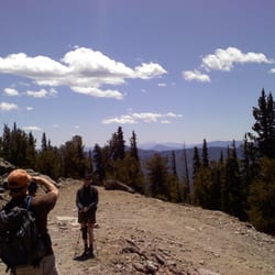
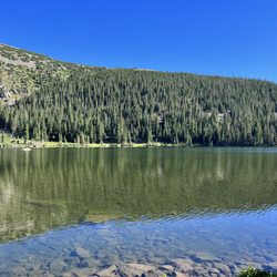
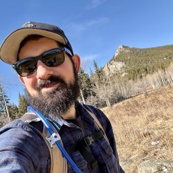
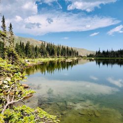
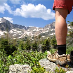
This is a great hike not too far outside Denver. I found out about this trail thanks to my "60 hikes within 60 miles" book. An aside-- I found that book in Barnes and Noble and impulsively decided to buy it. It's been a fabulous purchase! Some of you CO natives are probably rolling your eyes at me, but I've found a ton of lesser known hikes (as well as some very common ones) thanks to this book-- the most recent of which being Hell's Hole. Hell's Hole trail leads into Mt. Evans Wilderness about 30 min into the hike. About 20 minutes prior to this, there's a little stand where you must self register for a wilderness permit. There is no fee for this, it's basically just a way for the park service to keep track of info. The trailhead is off CO-103 on a pretty obscure road, West Chicago Creek. It gets pretty sketchy towards the end (very narrow road winding up a steep mountain with no guardrails...as long as I live here I'll never understand CO's aversion to guardrails in places like this) but it's well worth it. There's a campground near the trail head as well. The hike itself is a great workout with shade in the beginning and gorgeous views towards the end. Horses and dogs are welcome on the trail; mountain bikes are not permitted. The book I have estimated the total hike time to be 4.5 hours but I was pleasantly surprised to discover it only took me 3 hours, including a 30 min break at the turn around point and a couple photo/water opps. Obviously the hike time will vary for everyone; I guess the important thing to know is that it's 9 miles round trip. Though the hike is relatively long, it's not incredibly difficult. There are definitely some fairly steep portions, but a lot of it is at a relatively gentle incline. It seems like a fairly lightly used trail-- in the whole 3 hours I ran into about 3 other couples. It was really nice to enjoy the solitude, but also somewhat reassuring to know there were people somewhat nearby-- if you're hiking alone, like I was, it's always good to be aware! The trail ends in an open field with a creek nearby. It's around the treeline and you can see a couple fourteeners towering over you in this beautiful post-glacier valley. Definitely an ideal picnic spot! This trail is out-and-back, so once you've had enough of the scenery, it's time to pack it in and do it all over again! read more


9 years ago
More info about Hell's Hole Trail
101 Chicago Creek Rd
Idaho Springs, CO 80452
Directions
(303) 567-2901
Call Now
Hours
Outdoor Amenities


Hell's Hole Trail - hiking - Updated May 2026
Best of Idaho Springs
People found Hell's Hole Trail by searching for…
Things to Do in Idaho Springs, Colorado
Hiking Trails in Idaho Springs, Colorado
Parks in Idaho Springs, Colorado
Picnic Areas in Idaho Springs, Colorado
Picnic Spots in Idaho Springs, Colorado
Off Road Trails in Idaho Springs, Colorado
Running Trails in Idaho Springs, Colorado
Beautiful Views in Idaho Springs, Colorado
Mountain Biking in Idaho Springs, Colorado
Dog Friendly Hiking Trails in Idaho Springs, Colorado
Photo Spots in Idaho Springs, Colorado
Easy Hikes in Idaho Springs, Colorado
Off Leash Dog Hikes in Idaho Springs, Colorado
Scenic View in Idaho Springs, Colorado
Waterfalls in Idaho Springs, Colorado
View Points in Idaho Springs, Colorado
Tourist Attractions in Idaho Springs, Colorado
Picnic Tables in Idaho Springs, Colorado
Lookout Points in Idaho Springs, Colorado
Walking Trails in Idaho Springs, Colorado
To Do in Idaho Springs, Colorado
Trail in Idaho Springs, Colorado
Trending Searches in Idaho Springs, CO
Botanical Gardens near Hell's Hole Trail
Bounce House Rentals near Hell's Hole Trail
Campgrounds near Hell's Hole Trail
Cheap Plants near Hell's Hole Trail
Cherry Picking near Hell's Hole Trail
Cliff Jumping near Hell's Hole Trail
Dog Friendly Things To Do near Hell's Hole Trail
Flower Fields near Hell's Hole Trail
Flower Shop near Hell's Hole Trail
Garage Sales near Hell's Hole Trail
Garden Center near Hell's Hole Trail
Lakes & Ponds near Hell's Hole Trail
Nurseries & Gardening near Hell's Hole Trail
Outdoor Activities near Hell's Hole Trail
Outdoor Furniture Stores near Hell's Hole Trail
Party Equipment Rentals near Hell's Hole Trail
Pedicure near Hell's Hole Trail
Photo Spots near Hell's Hole Trail
Picnic Areas near Hell's Hole Trail
Places To Take Pictures near Hell's Hole Trail
Rock Quarry near Hell's Hole Trail
Running Trails near Hell's Hole Trail
Rv Rental near Hell's Hole Trail
Spray Tanning near Hell's Hole Trail
Sunrise View near Hell's Hole Trail
Swimming Holes near Hell's Hole Trail
Table And Chair Rentals near Hell's Hole Trail
Browse Brands
Related Searches in Idaho Springs, CO
Affordable Kayak Rental Services in Idaho Springs, Colorado
Best Fishing Locations and Guides in Idaho Springs, Colorado
Best Places for Horseback Riding in Idaho Springs, Colorado
Best Sledding Spots and Fun in Idaho Springs, Colorado
Check Out Off Road Trails in Idaho Springs, Colorado
Discover Dog Friendly Trails to Explore in Idaho Springs, Colorado
Discover Kid Friendly Hiking Trails in Idaho Springs, Colorado
Discover Scenic Waterfall Spots in Idaho Springs, Colorado
Discover Top Scenic Spots to Visit in Idaho Springs, Colorado
Discover a Hiking Trail in Idaho Springs, Colorado
Discover the Best Night Hike Trails in Idaho Springs, Colorado
Dog-Friendly Hikes With Dogs in Idaho Springs, Colorado
Enjoy Camping Adventures Around Idaho Springs, Colorado
Enjoy Exciting Mountain Biking Adventures in Idaho Springs, Colorado
Enjoy Kayaking Adventures in Idaho Springs, Colorado
Enjoy River Tubing Adventures in Idaho Springs, Colorado
Enjoy Tent Camping Spots Around Idaho Springs, Colorado
Enjoy Water Activities and Fun in Idaho Springs, Colorado
Enjoy a Beautiful Waterfall Hike in Idaho Springs, Colorado
Enjoy the Best Tubing Experiences in Idaho Springs, Colorado
Enjoy the Best Walking Trails in Idaho Springs, Colorado
Exciting Cliff Jumping Spots in Idaho Springs, Colorado
Experience Thrilling White Water Rafting in Idaho Springs, Colorado
Explore Beautiful Parks and Green Spaces in Idaho Springs, Colorado
Explore Easy Hikes Perfect for All in Idaho Springs, Colorado
Explore Fun Activities to Do in Idaho Springs, Colorado
Explore Popular Campgrounds Near Idaho Springs, Colorado
Explore Scenic Lakes to Visit in Idaho Springs, Colorado
Explore the Best Beach Spots in Idaho Springs, Colorado
Explore the Best Boating Spots in Idaho Springs, Colorado
Explore the Best Swimming Holes Around Idaho Springs, Colorado
Family Friendly Hiking With Kids in Idaho Springs, Colorado
Find Popular Ziplining Spots Around Idaho Springs, Colorado
Find the Best Playgrounds to Visit in Idaho Springs, Colorado
Find the Best Scenic View Locations in Idaho Springs, Colorado
Hiking Trails With Waterfalls in Idaho Springs, Colorado
Off Leash Dog Hiking Trails in Idaho Springs, Colorado
Plan a Scenic Drive Route Near Idaho Springs, Colorado
Popular Fishing Spots to Explore in Idaho Springs, Colorado
Popular Outdoor Activities to Try in Idaho Springs, Colorado
Popular Picnic Spots to Visit in Idaho Springs, Colorado
Popular Things to Do in Idaho Springs, Colorado
Safe River Swimming Areas in Idaho Springs, Colorado
Safe and Fun Parks for Kids in Idaho Springs, Colorado
Top Climbing Spots and Gyms in Idaho Springs, Colorado
Top Playgrounds for Kids to Enjoy in Idaho Springs, Colorado
Top Running Trails to Explore in Idaho Springs, Colorado
Top Swimming Lakes to Enjoy in Idaho Springs, Colorado