Anniversary Peak Photos


You might also consider
More like Anniversary Peak
Recommended Reviews - Anniversary Peak
Start your review...

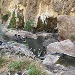
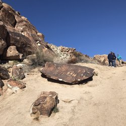
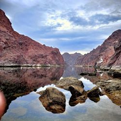
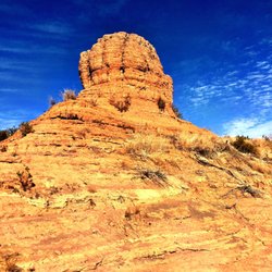
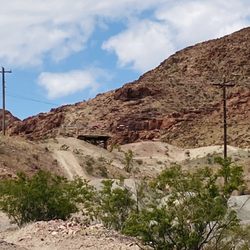
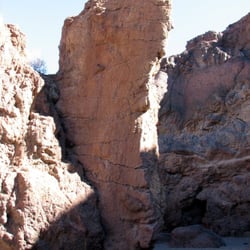
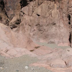
Rising over the Anniversary Mines and Narrows is Anniversary Peak along the Northshore Dr in LMNRA. I've been to mines and the Narrows, which is a really cool spot (the road is now closed off to the public until further notice, hopefully it will re-open again), we ended up parking right off the wash and hike in from there. This is my favorite kind of hike. All scrambling, no trail, mountaineers route. I'm not going to tell you how to get here, or any kind of GPS logistics, only because, I'm not here to get anyone lost. Like I said before, there is no defined trail. If you check summit post or peak bagger online, as well as bird and hike (that's not my favorite website) they can give you GPS coordinates. I'm gong to tell you what you can anticipate during this hike. It starts out flat, and as you head towards the bottom of the peak, you will going through a lot of brush, through a dry wash and once you hit the spot to start scrambling, it's straight up from there. Get your gloves out, you'll need them. Lots of velcro plants to avoid as well. A few spots, you will need to be able to life your entire body weight up and over. Once you climb up, you will hit a steep grade, this is what you will be on until you reach the peak. Once you are at the top, you are rewarded with panoramic views of Lake Mead. There is a summit log at the top to sign as well. This is a loop hike, so from there, you will be traversing across a steep ridgeline. If you are afraid of heights, this will give you some trouble. Once you hit the bottom of the mountain, you'll travel along the dry wash until it leads you right into the Narrows. This is a nice ending, enjoy the Narrows for a few, because once you come out, you will once again be going back up a very steep rock wall, and up and over, more scrambling and bouldering. This was a long and physical hike. Bring lots of water and snacks. Little to no shade. Definately not doable passed March, maybe April. If you are up for the challenge, I'd most definately recommend this hike. I'm going back for more myself. read more


More info about Anniversary Peak
MM4 Northshore Dr
Lake Mead National Recreation Area
Boulder City, NV 89005
Directions
Hours
Outdoor Amenities
You might also consider


Anniversary Peak - hiking - Updated May 2026
Best of Boulder City
People found Anniversary Peak by searching for…
Things to Do in Boulder City, Nevada
Hiking Trails in Boulder City, Nevada
Lookout Points in Boulder City, Nevada
Off Road Trails in Boulder City, Nevada
Viewpoints in Boulder City, Nevada
Scenic Views in Boulder City, Nevada
Lakes & Ponds in Boulder City, Nevada
Places to Walk at Night in Boulder City, Nevada
Walking Trails in Boulder City, Nevada
Trending Searches in Boulder City, NV
Botanical Gardens near Anniversary Peak
Bounce House Rentals near Anniversary Peak
Campgrounds near Anniversary Peak
Cliff Jumping near Anniversary Peak
Floral Designers near Anniversary Peak
Flower Fields near Anniversary Peak
Flower Shop near Anniversary Peak
Garage Sales near Anniversary Peak
Garden Center near Anniversary Peak
Lakes & Ponds near Anniversary Peak
Mens Suits near Anniversary Peak
Nurseries & Gardening near Anniversary Peak
Outdoor Activities near Anniversary Peak
Outdoor Furniture Stores near Anniversary Peak
Party Equipment Rentals near Anniversary Peak
Pedicure near Anniversary Peak
Photo Spots near Anniversary Peak
Picnic Areas near Anniversary Peak
Places To Take Pictures For Prom near Anniversary Peak
Plant Nursery near Anniversary Peak
Rock Quarry near Anniversary Peak
Running Trails near Anniversary Peak
Scenic Drive near Anniversary Peak
Scenic Night View near Anniversary Peak
Strawberry Picking near Anniversary Peak
Sunrise View near Anniversary Peak
Swimming Holes near Anniversary Peak
Browse Articles
Browse Brands
Related Searches in Boulder City, NV
Affordable Kayak Rental Services in Boulder City, Nevada
Best Fishing Locations and Guides in Boulder City, Nevada
Best Places for Horseback Riding in Boulder City, Nevada
Best Waterfalls and Swimming Holes in Boulder City, Nevada
Check Out Off Road Trails in Boulder City, Nevada
Discover Dog Friendly Trails to Explore in Boulder City, Nevada
Discover Scenic Mountain Bike Trails Near Boulder City, Nevada
Discover Scenic Walking Paths in Boulder City, Nevada, {State}
Discover Top Nature Parks to Visit in Boulder City, Nevada
Discover a Hiking Trail in Boulder City, Nevada
Discover the Best Night Hike Trails in Boulder City, Nevada
Discover the Best Running Track in Boulder City, Nevada
Dog-Friendly Hikes With Dogs in Boulder City, Nevada
Enjoy Camping Adventures Around Boulder City, Nevada
Enjoy Exciting Mountain Biking Adventures in Boulder City, Nevada
Enjoy Kayaking Adventures in Boulder City, Nevada
Enjoy Tent Camping Spots Around Boulder City, Nevada
Enjoy a Scenic Walk in Boulder City, Nevada, {State}
Enjoy the Best Walking Trails in Boulder City, Nevada
Exciting Cliff Jumping Spots in Boulder City, Nevada
Explore Beautiful Parks and Green Spaces in Boulder City, Nevada
Explore Easy Hikes Perfect for All in Boulder City, Nevada
Explore Fun Activities to Do in Boulder City, Nevada
Explore Popular Campgrounds Near Boulder City, Nevada
Explore Top Dog Parks in Boulder City, Nevada Near You
Explore the Best Beach Spots in Boulder City, Nevada
Explore the Best Boating Spots in Boulder City, Nevada
Explore the Best Trail Options in Boulder City, Nevada
Find Beautiful Views in Boulder City, Nevada
Find Cozy Camping Cabins in Boulder City, Nevada
Find Parks and Recreation Activities in Boulder City, Nevada
Find Popular Ziplining Spots Around Boulder City, Nevada
Find the Best Parks for Picnics in Boulder City, Nevada
Find the Best Scenic View Locations in Boulder City, Nevada
Hiking Trails With Waterfalls in Boulder City, Nevada
Off Leash Dog Hiking Trails in Boulder City, Nevada
Plan a Scenic Drive Route Near Boulder City, Nevada
Popular Fishing Spots to Explore in Boulder City, Nevada
Popular Outdoor Activities to Try in Boulder City, Nevada
Popular Picnic Spots to Visit in Boulder City, Nevada
Safe River Swimming Areas in Boulder City, Nevada
Safe and Fun Parks for Kids in Boulder City, Nevada
Top Climbing Spots and Gyms in Boulder City, Nevada
Top Paddleboarding Activities in Boulder City, Nevada
Top Running Trails to Explore in Boulder City, Nevada
Top Swimming Lakes to Enjoy in Boulder City, Nevada
Top Swimming Spots and Pools in Boulder City, Nevada
Top Things to Do With Kids in Boulder City, Nevada
People who viewed Anniversary Peak also viewed
Vivaldi Park
10 reviews
Anthem
PJ 5K and 1-Mile Walk
3 reviews
Sand & Surf Rentals
1 review
Anthem
Zen Divers
2 reviews
Town Square Park
53 reviews
Southeast
Hooked On Stripers
5 reviews
Monster Jam World Finals XVIII
1 review
Southeast
Fish and Wildlife Service
1 review
Northwest
Spooky Canyon
1 review
Lila with Kolina
1 review