804 Trail Photos
 - Hiking Near Me")


You might also consider
More like 804 Trail
Recommended Reviews - 804 Trail
Start your review...

Reviews With Photos


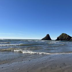
I love nothing better than walking the 804 trail with my camera; you never know what you'll see. The official trail runs 3/4 mile from Smelt Sands State Park, north to the sandy beach that lays between Yachats and Waldport. The trail meanders along the ancient pillow lava and basalt rock tide-pools. There is life in those pools and my camera explores them. There are wonderful churns where the surf is extruded into columns of spray shooting 30 and 40 feet into the air. In September and October, pods of Humpback whales feed along the shore. Walking the trail, their spouts, and individual whales are clearly visible as they break the surface of the water. Local artists build site specific works along the trail further enhancing the beauty of this truly magical place. The north end of the trail ends by gently sloping down to a 6 mile stretch of sandy beach. The trail calls me. I must return again and again. Perhaps one day I'll stay.

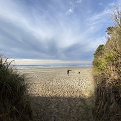
This is a great trail along the ocean in Yachats. It begins in a neighborhood and takes you down to the beach where you can see tidepools. There are a few benches along the trail where you can sit and relax and take in the gorgeous ocean view. It's most popular in the mornings, for tidepools, and evenings, for beautiful sunsets. The trail is pretty flat and expands about 2 miles. It connects to a couple of other trails in Yachats to the south, the Oregon Coast Trail (1 mile) and the Amanda Trail (1 mile). The trails are well maintained and perfect for a casual walk to take in the fresh ocean air. I would highly recommend! read more


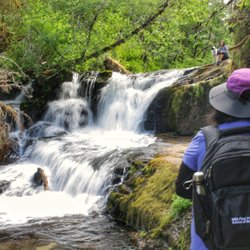
I've returned to this magnificent trail so many times over the years - my review is long overdue but it's kind of a hidden gem and I'm hoping it'll stay that way lol! This is probably my #1 fave trail of all time. It's not technically difficult by any means - it's short, almost entirely flat, and very well maintained. But it holds my heart bc there's a veritable feast for my lens in every nook and cranny and the environment changes year after year due to storms, tides, and sand levels rising and falling - a never ending photographer's paradise! And no doubt I'll be returning year after year for a long time. The trail runs about 1.5 miles from the sleepy coastal town of Yachats to its dead-end on a long sandy beach in the Cape Perpetua protected marine area. To say the tide pools here are amazing is an understatement. They are unparalleled! I've never seen so many colorful starfish, anemones, snails, barnacles, and tons of other undersea creepy crawlers anywhere else. The sunset and sunrise views are magical as well. And there are interesting pockets and tunnels created by mysterious wind swept coastal pines - just glorious! The giant dark basalt boulders are covered in so many species of barnacles and always changing shape due to erosion from wind and waves - creating so many fascinating pools to explore. The trail meanders past my fave hotel of all time too - the Overleaf Lodge. This is my happy place - my heart is always here. If you ever have the chance to visit, take it. read more


 - Hiking Near Me")
 - Hiking Near Me")

 - Hiking Near Me")


 - Hiking Near Me")

4 years ago
3 years ago
3 years ago
3 years ago
16 years ago
I love nothing better than walking the 804 trail with my camera; you never know what you'll see. The official trail runs 3/4 mile from Smelt Sands State Park, north to the sandy beach that lays between Yachats and Waldport. The trail meanders along the ancient pillow lava and basalt rock tide-pools. There is life in those pools and my camera explores them. There are wonderful churns where the surf is extruded into columns of spray shooting 30 and 40 feet into the air. In September and October, pods of Humpback whales feed along the shore. Walking the trail, their spouts, and individual whales are clearly visible as they break the surface of the water. Local artists build site specific works along the trail further enhancing the beauty of this truly magical place. The north end of the trail ends by gently sloping down to a 6 mile stretch of sandy beach. The trail calls me. I must return again and again. Perhaps one day I'll stay. read more


10 years ago
One of my favorite spots. The sea. Very fortunate to call this "Home #2." Our Heaven here on earth. read more

7 years ago
10 years ago
9 years ago
10 years ago
More info about 804 Trail
Yachats, OR 97498
Directions
(800) 551-6949
Call Now
Visit Website
http://www.yachats.org
Hours
Indoor Amenities
Outdoor Amenities
Ask the Community - 804 Trail
Review Highlights - 804 Trail


804 Trail - hiking - Updated June 2026
Best of Yachats
People found 804 Trail by searching for…
Things to Do in Yachats, Oregon
Sunset View in Yachats, Oregon
Hiking Trails in Yachats, Oregon
Dog Friendly Beaches in Yachats, Oregon
Waterfall Hike in Yachats, Oregon
Dog Friendly Hiking Trails in Yachats, Oregon
Sunrise View in Yachats, Oregon
Scenic Overlook in Yachats, Oregon
Kids Friendly Beaches in Yachats, Oregon
Secret Spots in Yachats, Oregon
Off Leash Dog Hiking Trails in Yachats, Oregon
Photo Spots in Yachats, Oregon
Running Trails in Yachats, Oregon
Secluded Spots in Yachats, Oregon
Parks for Kids in Yachats, Oregon
Watch Sunset in Yachats, Oregon
Walking Trails in Yachats, Oregon
Trending Searches in Yachats, OR
Browse Articles
Browse Nearby
BEST of Yachats, Oregon Parks near 804 Trail
BEST of Yachats, Oregon Restaurants near 804 Trail
BEST of Yachats, Oregon Lakes near 804 Trail
BEST of Yachats, Oregon Coffee near 804 Trail
BEST of Yachats, Oregon Things to Do near 804 Trail
BEST of Yachats, Oregon Breakfast near 804 Trail
BEST of Yachats, Oregon Lodging near 804 Trail
Browse Brands
Related Searches in Yachats, OR
Affordable Kayak Rental Services in Yachats, Oregon
Best Fishing Locations and Guides in Yachats, Oregon
Best Fun Things to Do in Yachats, Oregon
Best Places for Horseback Riding in Yachats, Oregon
Check Out Off Road Trails in Yachats, Oregon
Discover Popular Photo Spots in Yachats, Oregon
Discover Top Boat Tours in Yachats, Oregon for All Ages
Discover Top State Parks to Visit in Yachats, Oregon
Discover a Hiking Trail in Yachats, Oregon
Dog-Friendly Hikes With Dogs in Yachats, Oregon
Enjoy Camping Adventures Around Yachats, Oregon
Enjoy Tent Camping Spots Around Yachats, Oregon
Enjoy the Best Family Activities in Yachats, Oregon
Exciting Cliff Jumping Spots in Yachats, Oregon
Explore Beautiful Parks and Green Spaces in Yachats, Oregon
Explore Bike Rentals Throughout Yachats, Oregon
Explore Easy Hikes Perfect for All in Yachats, Oregon
Explore Fun Activities to Do in Yachats, Oregon
Explore Popular Campgrounds Near Yachats, Oregon
Explore Popular RV Parks Around Yachats, Oregon
Explore Popular View Points Around Yachats, Oregon
Explore Scenic Lakes to Visit in Yachats, Oregon
Explore Secret Spots Worth Visiting in Yachats, Oregon
Explore Top Dog Parks in Yachats, Oregon Near You
Explore Top Water Parks in Yachats, Oregon Today
Explore Whale Watching Tours in Yachats, Oregon
Explore the Best Beach Spots in Yachats, Oregon
Explore the Best Boating Spots in Yachats, Oregon
Explore the Best Swimming Holes Around Yachats, Oregon
Family Friendly Hiking With Kids in Yachats, Oregon
Find Fun Things to Do With Kids in Yachats, Oregon
Find the Best Parks for Picnics in Yachats, Oregon
Find the Best Playgrounds to Visit in Yachats, Oregon
Hiking Trails With Waterfalls in Yachats, Oregon
Plan a Scenic Drive Route Near Yachats, Oregon
Popular Kids Activities in Yachats, Oregon
Popular Picnic Spots to Visit in Yachats, Oregon
Popular Things to Do in Yachats, Oregon
Popular Things to See in Yachats, Oregon
Safe and Fun Parks for Kids in Yachats, Oregon
Top Climbing Spots and Gyms in Yachats, Oregon
Top Paddleboarding Activities in Yachats, Oregon
Top Places for Snorkeling in Yachats, Oregon
Top Playgrounds for Kids to Enjoy in Yachats, Oregon
Top Running Trails to Explore in Yachats, Oregon
Top Swimming Lakes to Enjoy in Yachats, Oregon
Top Swimming Spots and Pools in Yachats, Oregon
Top Things to Do With Kids in Yachats, Oregon
People who viewed 804 Trail also viewed
Cape Perpetua Scenic Area
53 reviews
Yachats State Recreation Area
3 reviews
Yaquina Bay Estuary Trail
2 reviews
Yaquina Estuary Trail
3 reviews
Nye Beach
19 reviews
Yaquina Bay South Jetty
1 review
Donald A Davis Park / Lincoln County Vietnam Memorial
3 reviews
Sea Lion Caves
236 reviews
Beachside State Recreation Site
19 reviews
Whale Park
1 review