Hobbit Beach Trailhead Photos


You might also consider
More like Hobbit Beach Trailhead
Recommended Reviews - Hobbit Beach Trailhead
Start your review...

Reviews With Photos

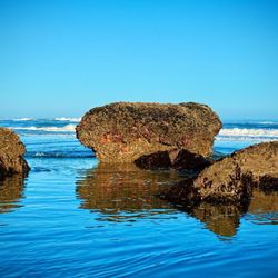
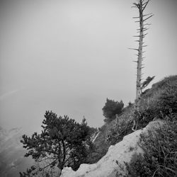
This is probably one of my fave trails I've ever hiked! It was magical and whimsical, with rewarding views around every corner! Not to mention it's a great workout! There are several options...you can just do the Hobbit Beach Trail itself which is about 1/2 mile long...I can't speak to the parking area or entrance for this one though bc I came from the lighthouse. Which brings me to the other option...you can hike to this beach from the Heceta Head Lighthouse as well (see my review for the lighthouse for more info and pics)...or hike to the lighthouse from here. If you do that, it's 2 miles (one way - so 4 miles there and back). On the 2 mile hike, you'll gain just over 1,000 feet in elevation and you'll traverse steep steps and hills and climb over rocks and roots so be aware! But it's soooo worth it! It's incredible! And there's lots of benches to rest on along the trail. But getting closer to the beach, it turns more ethereal, with moss dripping from giant, crooked and curvy tree trunks and branches and then the ground becomes sandy and the path narrows. You know you're close when you hear the waves and enter the "crab boneyard"!! Suddenly there are the remains of hundreds of thousands of crabs littered along the walls and floor of the trail! I have NO idea how they got there and couldn't find anything about it online lol...I dunno if people are putting them there or seals maybe? Or extremely high tides? A true mystery! The beach itself stretches on for miles and miles with cliffs behind it and it's beautiful...plenty of room for ample social distancing and room to run and frolic!

One of my favorite places to visit along the coast. A short beautiful hike along the aptly named Hobbit Trail ends with a nice open expanse of beautiful beach. Often it's a great place to find some peace & solitude although more and more people are visiting it these days. Still it's a great place to catch a sunset & enjoy nature. No bathrooms and very little parking available, but a true gem of a trail & beach.

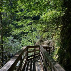
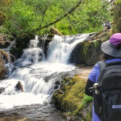
Two places to park at Heceta Lighthouse or the trailhead parking area further north on 101. It's on the right hand side but there is no visible sign;however, more than likely lots of cars will be parked there. From this parking area, you can hike on the China Creek trail (same side of the road as parking area about 1 mile total) or across 101 is the Hobbit trail (1.5 miles one way) and Hobbit Beach trail (.5 miles one way). The Hobbit trail leads to the Heceta Lighthouse and is pretty hilly. There are some stairs built in here and there. Otherwise, it's natural ground cover with slippery roots and muddy spots (even though it hadn't rained in a long time). There are benches here and there if you need a rest. The trail runs through a beautiful coastal forested area lined with tall Sitka spruce and rhododendrons. You actually expect to see a hobbit jump out somewhere. There are occasional ocean views notably of Hobbit Beach. It took us about 2 1/2 hours stopping to take lots of pictures. We thoroughly enjoyed ourselves!


2 years ago
This is a beautiful short walk that goes from the beach parking lot to the lighthouse. I've gone here several times and it's always gorgeous, even when it's foggy and raining. There are wild blackberries that grow along the path that you can snack on or take home with you if you go at the right time of the year, which is an added plus! The bathrooms by the beach parking lot are rough. They are not for the faint of heart or faint of nose. You're better off holding it until you can get to downtown Florence and use the public bathrooms there. read more


The Hobbit Trail would make JRR Tolkien proud. The trailhead is a subtle affair and easily found mainly due to the other cars parked at the trailhead. Parking is available on both sides of the highway, but remember, it's hwy 101 and traffic can be heavy. Because there is so much vehicle traffic as well as hikers coming and going, there are enough eyes there to make you feel okay about leaving your car there locked up. The trail itself starts out fairly smooth with gentle ups and downs, but get a bit more aggressive as you continue. A walking stick of some sort really comes in handy on a few of the steps and turns. As you progress towards the coast the forest starts to get thicker and darker like Mirkwood. The rays of diffuse sunlight scattered by drifting mists definitely lends a mystical element to the surroundings. Some of the trees are so twisted and gnarled that you might almost expect Treebeard or another Ent to come pacing past you. We did come across a gnome that was cleverly hidden by someone. After about a mile the trail reaches the end where the last section gets a bit steeper with plenty of roots to avoid. This is a very well used trail and there are a lot of very friendly hikers going both directions. The trail then opens onto a very large beautiful flat sandy beach with a cliff wall to your immediate south and a long flat sandy beach to the north. We found our first sandfall! A waterfall but it was sand, not water. Sand from the hillside above the cliffs was just pouring and cascading over the rocky edge. I posted a brief video of one with this review. All in all it was a good hike for a guy with a bum knee, anything worse than that should probably not try the whole trail. Mainly because a couple places had steps in and around roots that were probably around 1 to 2 foot steps. If you do push on to the bottom, the beach is worth it. Lots of very friendly smiling people and an awful lot of very well behaved dogs. I think the magic in this is that it was all so clean. The hike back out was easier than I had anticipated but there is no ADA assistance. read more


A short 1 mile trip down to the beach and back, perfect for families and most any ability. There's a small parking area right on the 101 just past the Haceta Head Lighthouse heading north. We stopped off Saturday midday and were able to get a spot. I hear it's quite crowded in general, but we only met a couple people on the trail that day. It's a short and easy 1/2 mile hike down. There are lots of little hiding places for the kiddos (and small adults such as myself) along the way. The entry area to the beach is unique and cute, and the beach itself was quiet and serene. Not much of a hike for exercise, but fun to check out...and I can definitely see why it's popular among families. read more


This is probably one of my fave trails I've ever hiked! It was magical and whimsical, with rewarding views around every corner! Not to mention it's a great workout! There are several options...you can just do the Hobbit Beach Trail itself which is about 1/2 mile long...I can't speak to the parking area or entrance for this one though bc I came from the lighthouse. Which brings me to the other option...you can hike to this beach from the Heceta Head Lighthouse as well (see my review for the lighthouse for more info and pics)...or hike to the lighthouse from here. If you do that, it's 2 miles (one way - so 4 miles there and back). On the 2 mile hike, you'll gain just over 1,000 feet in elevation and you'll traverse steep steps and hills and climb over rocks and roots so be aware! But it's soooo worth it! It's incredible! And there's lots of benches to rest on along the trail. But getting closer to the beach, it turns more ethereal, with moss dripping from giant, crooked and curvy tree trunks and branches and then the ground becomes sandy and the path narrows. You know you're close when you hear the waves and enter the "crab boneyard"!! Suddenly there are the remains of hundreds of thousands of crabs littered along the walls and floor of the trail! I have NO idea how they got there and couldn't find anything about it online lol...I dunno if people are putting them there or seals maybe? Or extremely high tides? A true mystery! The beach itself stretches on for miles and miles with cliffs behind it and it's beautiful...plenty of room for ample social distancing and room to run and frolic! read more


One of my favorite places to visit along the coast. A short beautiful hike along the aptly named Hobbit Trail ends with a nice open expanse of beautiful beach. Often it's a great place to find some peace & solitude although more and more people are visiting it these days. Still it's a great place to catch a sunset & enjoy nature. No bathrooms and very little parking available, but a true gem of a trail & beach. read more


 - Beaches Near Me")

 - Beaches Near Me")


Two places to park at Heceta Lighthouse or the trailhead parking area further north on 101. It's on the right hand side but there is no visible sign;however, more than likely lots of cars will be parked there. From this parking area, you can hike on the China Creek trail (same side of the road as parking area about 1 mile total) or across 101 is the Hobbit trail (1.5 miles one way) and Hobbit Beach trail (.5 miles one way). The Hobbit trail leads to the Heceta Lighthouse and is pretty hilly. There are some stairs built in here and there. Otherwise, it's natural ground cover with slippery roots and muddy spots (even though it hadn't rained in a long time). There are benches here and there if you need a rest. The trail runs through a beautiful coastal forested area lined with tall Sitka spruce and rhododendrons. You actually expect to see a hobbit jump out somewhere. There are occasional ocean views notably of Hobbit Beach. It took us about 2 1/2 hours stopping to take lots of pictures. We thoroughly enjoyed ourselves! read more

2 years ago
5 years ago
Short magical trail leading to a pretty beach. Limited parking on the side of the road for the Hobbit trailhead. Easy hike but watch the roots when you walk. Glad we discovered this little gem while visiting the Oregon Coast. read more


4 years ago
Charming hike down to a lovely beach with a grand stretch of sand! Be sure to collect a crab shell to add to the grotto on your way out read more

3 years ago
8 years ago
9 years ago
Such an awesome hike and beach! Went here with my Mom and little brother in between college visits a few years ago. Pretty close to the sea lion caves which is nice. In late August It was pretty cool which was really nice. The hike down to the beach is otherworldly, the mossy trees are so cool! The hike is mostly downhill and super beautiful and slow paced. The beach is so beautiful! There weren't very many people there. A really nice little adventure! It was also really nice because despite the downward slope climbing back up wasn't an issue for my poor, very arthritic joints. read more

More info about Hobbit Beach Trailhead
Florence, OR 97439
Directions
Hours
Outdoor Amenities
Ask the Community - Hobbit Beach Trailhead
Review Highlights - Hobbit Beach Trailhead


Why does Yelp recommend reviews?
1 review that is not currently recommended
The reviews below are not factored into the business's overall star rating.
10 months ago
Hobbit Beach Trailhead - beaches - Updated June 2026
Best of Florence
People found Hobbit Beach Trailhead by searching for…
Swimming Holes in Florence, Oregon
Hiking Trails With Waterfalls in Florence, Oregon
Things to Do in Florence, Oregon
Playgrounds in Florence, Oregon
Photo Spots in Florence, Oregon
Off Leash Dog Hiking Trails in Florence, Oregon
Stair Climbing in Florence, Oregon
Fun Things to Do for Adults in Florence, Oregon
Closest Beach in Florence, Oregon
Scenic Drive in Florence, Oregon
Places to Visit in Florence, Oregon
What to Do in Florence, Oregon
Place to Propose in Florence, Oregon
Toddler Playground in Florence, Oregon
Trending Searches in Florence, OR
Boat Rental near Hobbit Beach Trailhead
Cliff Jumping near Hobbit Beach Trailhead
Crabbing Location near Hobbit Beach Trailhead
Dog Friendly Beaches near Hobbit Beach Trailhead
Fishing Spots near Hobbit Beach Trailhead
Kayak Rental near Hobbit Beach Trailhead
Public Shower near Hobbit Beach Trailhead
River Swimming near Hobbit Beach Trailhead
Running Trails near Hobbit Beach Trailhead
Scenic Overlook near Hobbit Beach Trailhead
Splash Pad near Hobbit Beach Trailhead
Strawberry Picking near Hobbit Beach Trailhead
Swimming Holes near Hobbit Beach Trailhead
Swimming Lakes near Hobbit Beach Trailhead
Browse Articles
Browse Nearby
BEST of Florence, Oregon Restaurants near Hobbit Beach Trailhead
BEST of Florence, Oregon Coffee near Hobbit Beach Trailhead
BEST of Florence, Oregon Things to Do near Hobbit Beach Trailhead
BEST of Florence, Oregon Lakes near Hobbit Beach Trailhead
BEST of Florence, Oregon Tide Pools near Hobbit Beach Trailhead
BEST of Florence, Oregon Breakfast near Hobbit Beach Trailhead
BEST of Florence, Oregon Vacation Rentals near Hobbit Beach Trailhead
BEST of Florence, Oregon Resorts near Hobbit Beach Trailhead
BEST of Florence, Oregon Campgrounds near Hobbit Beach Trailhead
Browse Brands
Related Searches in Florence, OR
Affordable Kayak Rental Services in Florence, Oregon
Affordable Paddle Board Rental in Florence, Oregon
Best Crabbing Locations to Visit in Florence, Oregon
Best Fishing Locations and Guides in Florence, Oregon
Best Fun Things to Do in Florence, Oregon
Best Places for Horseback Riding in Florence, Oregon
Browse Top Hotels in Florence, Oregon for Your Stay
Browse Vacation Rentals to Book in Florence, Oregon
Check Out Off Road Trails in Florence, Oregon
Discover Dog Friendly Beaches Near Florence, Oregon
Discover Dog Friendly Trails to Explore in Florence, Oregon
Discover Popular Photo Spots in Florence, Oregon
Discover Public Beaches to Visit in Florence, Oregon
Discover Scenic Beach Camping Sites in Florence, Oregon
Discover Top Boat Tours in Florence, Oregon for All Ages
Discover a Hiking Trail in Florence, Oregon
Discover the Best Night Hike Trails in Florence, Oregon
Discover the Best Tide Pools in Florence, Oregon
Enjoy Camping Adventures Around Florence, Oregon
Enjoy Exciting Mountain Biking Adventures in Florence, Oregon
Enjoy Surfing Adventures in Florence, Oregon
Enjoy Tent Camping Spots Around Florence, Oregon
Enjoy Whale Watching Experiences in Florence, Oregon
Enjoy a Dog Beach Day in Florence, Oregon
Explore Beautiful Parks and Green Spaces in Florence, Oregon
Explore Bike Rentals Throughout Florence, Oregon
Explore Fun Activities to Do in Florence, Oregon
Explore Off Leash Dog Beaches in Florence, Oregon
Explore Popular Boat Charters Near Florence, Oregon
Explore Popular Campgrounds Near Florence, Oregon
Explore Popular RV Parks Around Florence, Oregon
Explore Popular Scenic Overlook Points in Florence, Oregon
Explore Popular View Points Around Florence, Oregon
Explore Scenic Lakes to Visit in Florence, Oregon
Explore Top Dog Parks in Florence, Oregon Near You
Explore Whale Watching Tours in Florence, Oregon
Explore the Best Beach Spots in Florence, Oregon
Explore the Best Boating Spots in Florence, Oregon
Family Friendly Hiking With Kids in Florence, Oregon
Find Top-Rated Disc Golf in Florence, Oregon
Find Top-Rated Waterfalls in Florence, Oregon Now
Find the Best Parks for Picnics in Florence, Oregon
Find the Best Swimming Pools in Florence, Oregon Today
Hiking Trails With Waterfalls in Florence, Oregon
Locate a Public Shower Facility in Florence, Oregon
Must-See Tourist Attractions Around Florence, Oregon
Off Leash Dog Hiking Trails in Florence, Oregon
Popular Fishing Spots to Explore in Florence, Oregon