Worthington State Forest Photos


You might also consider
More like Worthington State Forest
Recommended Reviews - Worthington State Forest
Start your review...

Reviews With Photos

This review is for the Applachian Trail to Sunfish Pond. For more info on the hike I recommend going to http://www.njhiking.com/best_hikes_in_nj_sunfish_pond/ The hike is quite popular as its one of the prettiest hikes in NJ. I wouldn't recommend it for newbies as its 7.6 miles with several inclines and is very rocky. Parts of the trail were quite wet which made the rocks pretty slippery. It took us about 2 hours to hike up and about an hour and 15 down. The reward at the top-a scenic lake. Quite a few other people on here mentioned seeing bears. As we were there on a Sunday in the summer most of the wildlife seemed to be scared and kept away. Tips: -Skip the porta- potties. They were disgusting. The visitor center has real bathrooms. -Skip google maps. It frequently gives people the wrong directions. Go to the website above for accurate directions. -Bring the bug spray. Even with it, I was getting bit.


The review is for their campground. We stayed in during the Columbus long weekend. It is our second time around and this time we were able to reserved sites at the very end part of the campground as we were a little late in booking. We (group of 5 ) were situated on an open field with a partial view of the river and full view of the mountain. The group feels safer during the entire stay as we were literally next to each other and far from the woods. The comfort house is few feet away from our location. Shower are on the left side and the toilets are on the right side.The toilets are provided with basic necessities such as toilet paper, hand soap and hand dryer. It has a power outlet and sufficient lighting. The shower has hot/cold water , clothes hooks and small table to put on our stuff. The campsite has an easy access from the road, easy to locate based on the map provided by the office and was regularly checked by the park ranger during day and night. They provide pre-registered service, easy check-in, and easy check-out services. Bundled of woods are available for sale in the office. A lot of hiking trails surrounded the campground, from easy to moderate to high degree. Maps are available in the office. The closest trail in our site that we tried had a 2 miles walk. Easy walk though the woods with a good view of the river. Will come back again.

We decided after a stay in PA to do the MT Tammany red to blue trail. I highly suggest arriving before 730 , we arrived around 745 and the lots were pretty packed. We were extremely lucky and found 1 open spot right by the trailhead. They did have people who worked there hanging under a tent which was nice in case you were unsure were to go. But once we started our hike... Wow ! What a workout. I've finally invested in walking sticks and I highly recommend bringing them! They help so much because of all the scrambles there are to get to the top. The first look out you come to is less than a half mile up. That was actually my favorite viewpoint. Gorgeous view and a lot of people didn't stop at it thinking the top would be even better. I'm so glad we took some time here! A while later we hit what we though was the final viewpoint with tons of trees. Keep going ! It's not it .. but if you want some peace and quiet I highly suggest sitting for a snack or just to relax because the final viewpoint is packed with people. It was a cool view seeing how high up you were but is was pretty crowded. We only spend a few minutes here and left to race to the waterfall area. What a great way to end a hike. It was beautiful and so relaxing. As you get closer to the falls you hear all the birds and the water running. It was a super hot day and my feet hurt from all the rocks that I decided to dip my feet in and it was awesome ! If the water wasn't so so cool I probably would have went in. After hanging here for a while we proceeded on and the rest of the hike was along a stream with a few small stop offs to take it all in. This hike is definitely doable ! But on a hot day it could be overwhelming. Also we did see a small bear. It didn't seem interested in us at all.. thankfully but be alert. My recommendation is to head out super early, bring walking sticks . RED TO BLUEE and definitely ice water.

I love this place. There is so much to do, but we went to hike Mount Tammany. This was such an amazing place to hike (some climb) for someone new or intermediary. If climbing Mount Tammany: 1) Take the red trail up. Where you will find some challenging spots. And your hands and feet with come in handy. 2) When you reach up, use the white trail to find the viewing area. 3) Then use the blue trail to come down. Also, there is a small waterfalls there to refresh yourself.


This was my first trip out here and it was awesome. I came for the hikes as much as the camping and it was beyond what I expected. The (paid) campgrounds are located within the proximity of the Appalachian Trail, so it's very easy to set up shop and head out through the various trails to get up to it, or just stay off the beaten path (and even in the semi-off season, it was slightly crowded) and explore the less traveled trails. Sunfish pond is pretty, but it's almost at the top of the mountain so please be aware that these hikes are somewhat challenging. All are uphill and most are pretty steep. You can venture further up on Old Mill Road and visit some other trails and sights (like Millbrook Village which is abandoned). But those places are in the Delaware National Recreation Area. Once you get back to camp you can enjoy a fire in the existing fire pit. They sell wood at the Ranger's Station ($7 when I was there) or you can bring your own. The bathrooms were clean, and there's even showers available. There's no alcohol allowed on the campgrounds so please be aware that the police and rangers patrol the area, and keep the food out of your tent and general vicinity. There is lots of wildlife and although I didn't see any bears, I heard lots of commotion outside once we all layed down for the night, luckily all the food was safely inside the cars.


This place is absolutely beautiful!!! We came out to Del Water Gap for some hiking and a night of camping in October. The weather was perfect and the fall foliage was peak which enhanced the experience. We paid $20 for one night and had our choice of campsites because it was a Monday in October. Found a more private site and set up camp with an amazing view of the Delaware river (and a golf course across the way). There are plenty of hiking trails and recreation areas, although in October most facilities are closed. The privacy and seclusion was actually a perk for us (until it got dark). There is a large bear population here and everywhere you turn is a sign reminding you. Once it got dark every noise we heard had us spooked. We never saw a bear, only a raccoon and a skunk but we were on high alert the whole time. I highly recommend this place to anyone looking for a great camp area near Del Water Gap. Can't wait to return!

Mt. Tammany was a beautiful 3-hour hike since we took breaks and a bunch of pictures. The view is incredible at the top- green forests and a blue river running along. We were lucky to find a parking spot and started at the red dot trail. There were some steep and rocky sections going uphill, but my friend who's a beginner hiker was able to manage. There were some parts where we were not sure where to go, but just look out for the red dots to guide you. Once you reach the top, savor the view. The blue trail back down wasn't as steep and more woodsy. At the end of the trail, there is a creek with little waterfalls which people were taking a dip in. Water looked clear. We did see a snake cross our path, but they're usually nocturnal. We spotted a baby black bear, fortunately as we were driving by. We had some slight trouble finding the trail but the park ranger at the office was very helpful and even gave us maps. 1. Bring a lunch to eat when you reach the top 2. Bring swimwear / towel if you want to take a dip

What a great experience. We did the red to blue dot trail. The REd trail was challenging but felt so rewarding to know you completed it on day the top. There are two view points on the red trail. From my experience the first view point on the way up was better. Once at the top it was loaded with people hanging out on a rock ledge. But if there weren't as many people there I'm sure it would have been a wonderful view. On the way down we took the blue trail which seemed to be less challenging. This has no view point out but the whole time you are walking through the woods. Don't get discouraged while going down the blue trail though. About a quarter mile from the end there is a beautiful waterfall. It's small but it's great for pictures. Unfortunately we didn't get any pictures because there was a family of 12 hanging out under the water. It's a small waterfall but it's nice and relaxing to look at. The rest of the hike down to the car is walking along a beautiful river. I thought swimming a couple times but got reminded that we had a two hour drive home. Keep in mind that there is plenty of wild life. We saw a baby bear which means the mother probably wasn't far behind and deer.

2 years ago
Stunning views at Worthington State Forest! Beach careful while driving to the camp ground registration area. Slow down because the two-way traffic road narrows at some parts. Looking forward to visiting again! read more


6 years ago
Hello Yelp World! This is my first review, not for a restaurant, but for this spectacular hike up Mount Tammany at Worthington State Forest. So I've picked up hiking the last few years because not only is it great exercise and you get to enjoy awesome views but it's free, unless you count the cost of getting there. My first attempt at hiking here was denied several weeks ago when I came on a Sunday at 10am, huge mistake! Because of the pandemic, only the Kittatinny Point Visitor Center lot is open, and by this time on a weekend the parking lot was packed to the gills. So do yourself a favor and either avoid coming here late, or not come at all on a weekend, otherwise the park ranger will turn you away if the lot is full. Today I got here at 9am. Score!!! Only a half-dozen cars were parked here on this Monday morning. Follow the signs to the beginning of the red dot trail, which is located on the west side of Route 80, to begin this challenging hike. There are other trails at Mount Tammany but the red-blue trail seems to most popular. Be warned, the trail is quite steep and will involve a lot of rock scrambles. I will admit my teenage son was flying up the mountain while I was taking it slow and gasping for air, haha! So if you haven't twisted an ankle or got bit by a rattlesnake or copperhead - yes, there is a signpost warning about the snakes, but I didn't see any - you will come upon two overlooks with beautiful views of Mt. Minsi and the Delaware Water Gap. The first viewpoint is about three-quarters of the way up the red trail and the other one is at the summit. You should definitely scramble down the rocks a bit if you're comfortable with it to get much better vistas. After taking in the views and catching your breath you will continue along the red dot trail which will connect you with the blue dot trail. Follow the blue trail to descend the mountain. While not as steep coming down, there are still lots of loose rocks that you need to be wary of. As you near the end of your hike on the blue dot trail, you are rewarded once again with a beautiful little waterfall. Hikers were wading in the stream here to cool off, but I took a pass. Once you've finished taking your pictures here, cross the bridge and continue on the white trail, which is actually part of the Appalachian Trail, and you will end up back at the beginning of the red dot trail where you began. You can now go back under the underpass to head back to your car at the visitor center. read more


3 years ago
4 years ago
2 years ago
This review is for the Applachian Trail to Sunfish Pond. For more info on the hike I recommend going to http://www.njhiking.com/best_hikes_in_nj_sunfish_pond/ The hike is quite popular as its one of the prettiest hikes in NJ. I wouldn't recommend it for newbies as its 7.6 miles with several inclines and is very rocky. Parts of the trail were quite wet which made the rocks pretty slippery. It took us about 2 hours to hike up and about an hour and 15 down. The reward at the top-a scenic lake. Quite a few other people on here mentioned seeing bears. As we were there on a Sunday in the summer most of the wildlife seemed to be scared and kept away. Tips: -Skip the porta- potties. They were disgusting. The visitor center has real bathrooms. -Skip google maps. It frequently gives people the wrong directions. Go to the website above for accurate directions. -Bring the bug spray. Even with it, I was getting bit. read more

5 years ago
We stayed here during a 70 mile Bike-packing trip, loop around the Delaware. It was a great campground and the staff was very helpful. We stayed at Campground 31 along the River. I would recommend it to anyone that wants to camp nearby. read more


11 years ago
The review is for their campground. We stayed in during the Columbus long weekend. It is our second time around and this time we were able to reserved sites at the very end part of the campground as we were a little late in booking. We (group of 5 ) were situated on an open field with a partial view of the river and full view of the mountain. The group feels safer during the entire stay as we were literally next to each other and far from the woods. The comfort house is few feet away from our location. Shower are on the left side and the toilets are on the right side.The toilets are provided with basic necessities such as toilet paper, hand soap and hand dryer. It has a power outlet and sufficient lighting. The shower has hot/cold water , clothes hooks and small table to put on our stuff. The campsite has an easy access from the road, easy to locate based on the map provided by the office and was regularly checked by the park ranger during day and night. They provide pre-registered service, easy check-in, and easy check-out services. Bundled of woods are available for sale in the office. A lot of hiking trails surrounded the campground, from easy to moderate to high degree. Maps are available in the office. The closest trail in our site that we tried had a 2 miles walk. Easy walk though the woods with a good view of the river. Will come back again. read more


We decided after a stay in PA to do the MT Tammany red to blue trail. I highly suggest arriving before 730 , we arrived around 745 and the lots were pretty packed. We were extremely lucky and found 1 open spot right by the trailhead. They did have people who worked there hanging under a tent which was nice in case you were unsure were to go. But once we started our hike... Wow ! What a workout. I've finally invested in walking sticks and I highly recommend bringing them! They help so much because of all the scrambles there are to get to the top. The first look out you come to is less than a half mile up. That was actually my favorite viewpoint. Gorgeous view and a lot of people didn't stop at it thinking the top would be even better. I'm so glad we took some time here! A while later we hit what we though was the final viewpoint with tons of trees. Keep going ! It's not it .. but if you want some peace and quiet I highly suggest sitting for a snack or just to relax because the final viewpoint is packed with people. It was a cool view seeing how high up you were but is was pretty crowded. We only spend a few minutes here and left to race to the waterfall area. What a great way to end a hike. It was beautiful and so relaxing. As you get closer to the falls you hear all the birds and the water running. It was a super hot day and my feet hurt from all the rocks that I decided to dip my feet in and it was awesome ! If the water wasn't so so cool I probably would have went in. After hanging here for a while we proceeded on and the rest of the hike was along a stream with a few small stop offs to take it all in. This hike is definitely doable ! But on a hot day it could be overwhelming. Also we did see a small bear. It didn't seem interested in us at all.. thankfully but be alert. My recommendation is to head out super early, bring walking sticks . RED TO BLUEE and definitely ice water. read more


 - Parks Near Me - Columbia, New Jersey")

4 years ago
3 years ago
4 years ago
12 years ago
I love this place. There is so much to do, but we went to hike Mount Tammany. This was such an amazing place to hike (some climb) for someone new or intermediary. If climbing Mount Tammany: 1) Take the red trail up. Where you will find some challenging spots. And your hands and feet with come in handy. 2) When you reach up, use the white trail to find the viewing area. 3) Then use the blue trail to come down. Also, there is a small waterfalls there to refresh yourself. read more


12 years ago
We hiked all the way to the top of Mt. Tammany (1527ft above sea level). The climb was roughly 1.5/2 hours of hiking on top of rocks at an incline, which proved to be pretty arduous, but it was definitely worth it! The views were spectacular! See my pics :) read more


14 years ago
This was my first trip out here and it was awesome. I came for the hikes as much as the camping and it was beyond what I expected. The (paid) campgrounds are located within the proximity of the Appalachian Trail, so it's very easy to set up shop and head out through the various trails to get up to it, or just stay off the beaten path (and even in the semi-off season, it was slightly crowded) and explore the less traveled trails. Sunfish pond is pretty, but it's almost at the top of the mountain so please be aware that these hikes are somewhat challenging. All are uphill and most are pretty steep. You can venture further up on Old Mill Road and visit some other trails and sights (like Millbrook Village which is abandoned). But those places are in the Delaware National Recreation Area. Once you get back to camp you can enjoy a fire in the existing fire pit. They sell wood at the Ranger's Station ($7 when I was there) or you can bring your own. The bathrooms were clean, and there's even showers available. There's no alcohol allowed on the campgrounds so please be aware that the police and rangers patrol the area, and keep the food out of your tent and general vicinity. There is lots of wildlife and although I didn't see any bears, I heard lots of commotion outside once we all layed down for the night, luckily all the food was safely inside the cars. read more


7 years ago
Great views of the Delaware water gap. Trails were not very difficult. Two different path you can take. Very easy to get to from New Jersey and eastern PA. read more

7 years ago
14 years ago
This place is absolutely beautiful!!! We came out to Del Water Gap for some hiking and a night of camping in October. The weather was perfect and the fall foliage was peak which enhanced the experience. We paid $20 for one night and had our choice of campsites because it was a Monday in October. Found a more private site and set up camp with an amazing view of the Delaware river (and a golf course across the way). There are plenty of hiking trails and recreation areas, although in October most facilities are closed. The privacy and seclusion was actually a perk for us (until it got dark). There is a large bear population here and everywhere you turn is a sign reminding you. Once it got dark every noise we heard had us spooked. We never saw a bear, only a raccoon and a skunk but we were on high alert the whole time. I highly recommend this place to anyone looking for a great camp area near Del Water Gap. Can't wait to return! read more


13 years ago
Mt. Tammany was a beautiful 3-hour hike since we took breaks and a bunch of pictures. The view is incredible at the top- green forests and a blue river running along. We were lucky to find a parking spot and started at the red dot trail. There were some steep and rocky sections going uphill, but my friend who's a beginner hiker was able to manage. There were some parts where we were not sure where to go, but just look out for the red dots to guide you. Once you reach the top, savor the view. The blue trail back down wasn't as steep and more woodsy. At the end of the trail, there is a creek with little waterfalls which people were taking a dip in. Water looked clear. We did see a snake cross our path, but they're usually nocturnal. We spotted a baby black bear, fortunately as we were driving by. We had some slight trouble finding the trail but the park ranger at the office was very helpful and even gave us maps. 1. Bring a lunch to eat when you reach the top 2. Bring swimwear / towel if you want to take a dip read more


What a great experience. We did the red to blue dot trail. The REd trail was challenging but felt so rewarding to know you completed it on day the top. There are two view points on the red trail. From my experience the first view point on the way up was better. Once at the top it was loaded with people hanging out on a rock ledge. But if there weren't as many people there I'm sure it would have been a wonderful view. On the way down we took the blue trail which seemed to be less challenging. This has no view point out but the whole time you are walking through the woods. Don't get discouraged while going down the blue trail though. About a quarter mile from the end there is a beautiful waterfall. It's small but it's great for pictures. Unfortunately we didn't get any pictures because there was a family of 12 hanging out under the water. It's a small waterfall but it's nice and relaxing to look at. The rest of the hike down to the car is walking along a beautiful river. I thought swimming a couple times but got reminded that we had a two hour drive home. Keep in mind that there is plenty of wild life. We saw a baby bear which means the mother probably wasn't far behind and deer. read more


We did the Tammany trail, which was pretty challenging! We started the opposite way, from blue trail to red trail because the parking lot near the red trail was filled. Some parts are through the woods (where there was a deer following some hikers) and then it becomes a steeper rockier climb. Make sure you bring lots of water and snacks! It took us about 2 hours up and about an hour down. It was not too crowded and the trails vary from paths to just a marked tree. Also, we saw a couple of dogs, so bring your pet if it's active! The only thing that's annoying is that we had to walk on the highway on the way back to the start of the blue trail since that's where we parked. http://www.state.nj.us/dep/parksandforests/parks/maps/worthington%20map_sm.pdf read more


11 years ago
By far my favorite campground! We stayed at campsite 20 which was a huge site right on the waterfront (which BTW in front of an unexpected fireworks show which was awesome). Site came with a fire pit and lighting post. Bathrooms were spotless (and showers). We also hiked up mt. Tammany which was fantastic. Honestly nothing bad to say about this place. I am definitely looking forward to going back. read more


9 years ago
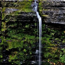
WARNING: This review comes with threat of bear attack. This is one of the most beautiful places in all of New Jersey and the entire tri-state area. I've decided to review each of the parks that make up this massive wilderness system, rather than lump them in one review. I'll bet you didnt think you'd see the phrase "massive wilderness system" and "New Jersey" in the same review, did you? Well this forested area is 6,600 acres, and the parks in toto comprise over 70,000 acres (if you add all the forest on the PA side of the river, you're way over 100,000 acres of forest). Worthington is the park that has the famed, Delaware Water Gap, once one of the most visited places in America and an amazing geologic formation. I grew up 25 miles from The Gap (which forever means something to me other than an overpriced clothing store pushing inferior quality goods), and it's still comforting to see that giant "hole" in the mountains. Far more impressive to drive through The Gap on Route 80, and better still to pull off the road into one of the state lots and hike to the top of Mount Tammany for a spectacular view of 3 states. Additionally, there is a gorgeous glacial pond on top of the mountain, wonderful streams with wild (and tasty) brook trout, scenic waterfalls (Pic 1), and some nice swimming holes (be careful, and dont swim in them unless you're used to swimming in gorges). Given that this is NYC Yelp, I do have to make one stern warning. This is bear country. No.... like big-time black bear country. To give you some perspective, there are more bears in this part of NJ than there are Toyota Prius on the UWS. They are usually very peaceful animals, and rarely ever hurt people. Sure, some dogs and cats get munched each year, but they're snack sized. The only time you might have cause to worry is if you stumble upon a mother bear and her cub(s), which brings us to Memorial Day, when I was near the top of Tammany literally standing on a cliff (admiring view), when a mother and her cub (Pic 2) stumbled through the woods about 50 to 70 feet from me. I knew immediately this was the worst case possible scenario, because if Mom views me as a threat to her cub, I have nowhere to run since I'm on a ledge (Pic 3) with about a 60 foot drop. I still wasnt THAT concerned, I just made myself "small" and pulled out my phone and snapped some pics (sorry they're crappy). Just be smart and dont do anything threatening, especially if they have babies and you'll be fine. In this instance, mama bear walked a bit closer to "inspect" me, lost interest upon seeing I wasnt a danger, and just kept foraging for food (flipping up big rocks with one paw that would take a human both hands/arms). Net/net, this is a spectacular park and seeing bears in the wild is one of the coolest things you can imagine. You may have to visit a bunch of times before you do get to see a wild bear, but I promise it will be worth it if do! read more


4 years ago
14 years ago
13 years ago
10 years ago
Camped out for almost a week at site 17 from Aug 2-5, 2016 it was nice and secluded, no easy access to the river or view of the river. That was the only downside, we had a friendly skunk who visited us every night. Cozy, Bathrooms were clean and the showers were decent. read more


 8-4-16 - Parks Near Me - Columbia, New Jersey")

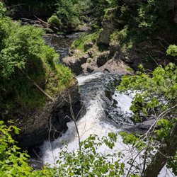
We went on a beautiful 3 mile circular hike here. The hike had amazing views and was challenging yet manageable. The views included tiny creeks, waterfalls, and overlooking views of the mountains. It took us a little over 2 hours and we took some breaks. I would definitely recommend this hike! read more

8 years ago
10 years ago
10 years ago
9 years ago
Easily parked at the beginning of the Red Trail. Rocky climb to the top but worth the effort. Beautiful sites to be seen! read more

Page 1 of 2
More info about Worthington State Forest
Ask the Community - Worthington State Forest
Review Highlights - Worthington State Forest
You might also consider


Why does Yelp recommend reviews?
3 reviews that are not currently recommended
The reviews below are not factored into the business's overall star rating.
4 years ago
10 years ago
Worthington State Forest - parks - Updated July 2026
Best of Columbia
People found Worthington State Forest by searching for…
Trending Searches in Columbia, NJ
Black Owned Nail Salons near Worthington State Forest
Boat Rental near Worthington State Forest
Day Trips near Worthington State Forest
River Swimming near Worthington State Forest
River Tubing near Worthington State Forest
Soccer Store near Worthington State Forest
Splash Pad near Worthington State Forest
Browse Articles
Browse Nearby
BEST of Columbia, New Jersey Restaurants near Worthington State Forest
BEST of Columbia, New Jersey Things to Do near Worthington State Forest
BEST of Columbia, New Jersey Coffee near Worthington State Forest
BEST of Columbia, New Jersey Breakfast near Worthington State Forest
BEST of Columbia, New Jersey Shopping near Worthington State Forest
BEST of Columbia, New Jersey Bowling near Worthington State Forest
Browse Brands
Related Searches in Columbia, NJ
Affordable Kayak Rental Services in Columbia, New Jersey
Best Fishing Locations and Guides in Columbia, New Jersey
Best Fun Things to Do in Columbia, New Jersey
Best Nature Trails for Hiking in Columbia, New Jersey
Best Off Leash Dog Parks in Columbia, New Jersey
Best Parks for Parties and Events in Columbia, New Jersey
Best Places for Horseback Riding in Columbia, New Jersey
Best Sledding Spots and Fun in Columbia, New Jersey
Best Things to Do on a Rainy Day in Columbia, New Jersey
Best Water Parks for Kids in Columbia, New Jersey
Best Waterfalls and Swimming Holes in Columbia, New Jersey
Check Out Great Playgrounds in Columbia, New Jersey
Check Out Off Road Trails in Columbia, New Jersey
Discover Baseball Fields Around Columbia, New Jersey
Discover Dog Friendly Trails to Explore in Columbia, New Jersey
Discover Fun Toddler Parks in Columbia, New Jersey for Your Little One
Discover Lakes & Ponds to Explore in Columbia, New Jersey
Discover Popular Bike Trails in Columbia, New Jersey
Discover Popular Photo Spots in Columbia, New Jersey
Discover Scenic Mountain Bike Trails Near Columbia, New Jersey
Discover Soccer Fields in Columbia, New Jersey Near You
Discover Top Nature Parks to Visit in Columbia, New Jersey
Discover a Hiking Trail in Columbia, New Jersey
Discover the Best Night Hike Trails in Columbia, New Jersey
Dog-Friendly Hikes With Dogs in Columbia, New Jersey
Effective Stairs Workout Spots in Columbia, New Jersey
Enjoy Camping Adventures Around Columbia, New Jersey
Enjoy Exciting Mountain Biking Adventures in Columbia, New Jersey
Enjoy Kayaking Adventures in Columbia, New Jersey
Enjoy River Tubing Adventures in Columbia, New Jersey
Enjoy Tent Camping Spots Around Columbia, New Jersey
Enjoy the Best Picnic Spots and Ideas in Columbia, New Jersey
Enjoy the Best Tubing Experiences in Columbia, New Jersey
Enjoy the Best Walking Trails in Columbia, New Jersey
Exciting Cliff Jumping Spots in Columbia, New Jersey
Explore Beautiful Parks and Green Spaces in Columbia, New Jersey
Explore Bike Rentals Throughout Columbia, New Jersey
Explore Easy Hikes Perfect for All in Columbia, New Jersey
Explore Family-Friendly Zoos and Wildlife in Columbia, New Jersey
Explore Free Picnic Areas Around Columbia, New Jersey
Explore Free Things to Do Around Columbia, New Jersey
Explore Landmarks & Historical Buildings in Columbia, New Jersey
Explore Parks With Pull Up Bars in Columbia, New Jersey
Explore Popular Campgrounds Near Columbia, New Jersey
Explore Popular RV Parks Around Columbia, New Jersey
Explore Popular View Points Around Columbia, New Jersey
Explore Scenic Lakes to Visit in Columbia, New Jersey
Explore Summer Camps for All Ages in Columbia, New Jersey
People who viewed Worthington State Forest also viewed
Bushkill Falls
355 reviews
Rail Gap Pocono Creek Nature Preserve
2 reviews
Kittatinny Point
3 reviews
Mount Tammany
8 reviews
Scenic Overlook
4 reviews
Sparta Glen
3 reviews
High Point Monuments of Sussex County
5 reviews
Delaware Water Gap Nra
10 reviews
Crater Lake
3 reviews
Edge of the Woods Outfitters
118 reviews
$$