Mount Tammany Photos


You might also consider
Recommended Reviews - Mount Tammany
Start your review...

Reviews With Photos

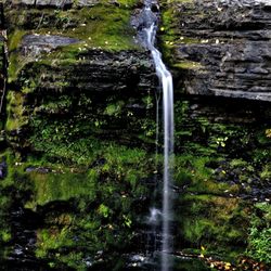
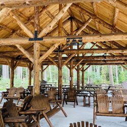
Me and a few friends decided to go on a spontaneous hiking trip. This hike was one to definitely remember it was filled with steep trails & a lot of rocky terrain. There was a easy trail in Aahar one easy was blue, hard was red. This trail was filled with tons of beautiful spots to take pictures of the scenery was amazing definitely breathtaking once you reach the top it is worth it without a doubt. I recommend this trail if you want to have a challenging hike definitely wear boots to avoid slips, falls and sore ankles while wearing sneakers that was a mistake I made, lol. There is even several small little waterfalls, one of them people were actually in the water. There's also picnic areas to eat & trail has enough room so that people aren't congested. The parking is outrageous, but there was 3 parking lots full of cars, so we were lucky enough to get a spot. The rangers did a great job at directing us to a good spot and answering all questions we had.
This is a decently rigorous hike, though I'm scared of heights and there aren't any places where I felt like I might fall - no major dropoffs to navigate around on the way up or anything. But it is steep! You'll have to do a little scrambling to get up there. But the view is absolutely worth it. Beautiful and challenging hike - one of my favorites in the area. The trail is pretty crowded, and people are everywhere taking photos (and asking me to take them, haha), so if you like solitary hikes, I'd pick a weekday off time and hope for the best. Lots of dogs on the trail, as well. Enjoy your hike!

On the way home from a couple of days of camping we stopped by Mt. Tammany to take a hike (and hopefully miss the traffic coming into the city) and I'm glad that we did. It was way more intense then I expected. For most hikers this trail was probably like a level 5 of 10, but it really kicked my butt. It took a couple of hours to make it to the top and a little less to make it down. It was worth the time and effort and was a great experience. Check it out and bring plenty of water.

2 years ago


6 years ago
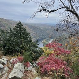
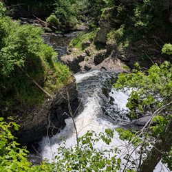
Great hike with a beautiful view but certainly not for the weak! The red trail going up has a very steep elevation climb in a shorter distance up to the peak where you'll see the landmark view over the Delaware Water Gap everyone loves snapping pictures of. Certainly harder for those not acclimated to steady hiking/climbing and not pup-friendly at all! The blue trail is longer in distance but a bit steadier in elevation, easier for the pups and for those not that conditioned to hiking but still hard on the knees coming down. Much more to see along the blue trail though as you'll pass two bridges, see a couple waterfalls and river beds that you can walk through. Taking the red trail up and the blue down seems to be the typical route and the one I usually take when I'm on my own or with one or two others but considering this last time up I went with my parents and two pups, we took the blue trail up and down and still got a great workout in! Remember to stay alert on this trail especially around the change of seasons! On just one visit, we stumbled across a wasp nest, a black bear cub that ran right across the walking path seconds in front of us and a nice big snake slithering out of a tree I stopped to tie my shoe against! read more


Me and a few friends decided to go on a spontaneous hiking trip. This hike was one to definitely remember it was filled with steep trails & a lot of rocky terrain. There was a easy trail in Aahar one easy was blue, hard was red. This trail was filled with tons of beautiful spots to take pictures of the scenery was amazing definitely breathtaking once you reach the top it is worth it without a doubt. I recommend this trail if you want to have a challenging hike definitely wear boots to avoid slips, falls and sore ankles while wearing sneakers that was a mistake I made, lol. There is even several small little waterfalls, one of them people were actually in the water. There's also picnic areas to eat & trail has enough room so that people aren't congested. The parking is outrageous, but there was 3 parking lots full of cars, so we were lucky enough to get a spot. The rangers did a great job at directing us to a good spot and answering all questions we had. read more

This is a decently rigorous hike, though I'm scared of heights and there aren't any places where I felt like I might fall - no major dropoffs to navigate around on the way up or anything. But it is steep! You'll have to do a little scrambling to get up there. But the view is absolutely worth it. Beautiful and challenging hike - one of my favorites in the area. The trail is pretty crowded, and people are everywhere taking photos (and asking me to take them, haha), so if you like solitary hikes, I'd pick a weekday off time and hope for the best. Lots of dogs on the trail, as well. Enjoy your hike! read more


2 years ago
On the way home from a couple of days of camping we stopped by Mt. Tammany to take a hike (and hopefully miss the traffic coming into the city) and I'm glad that we did. It was way more intense then I expected. For most hikers this trail was probably like a level 5 of 10, but it really kicked my butt. It took a couple of hours to make it to the top and a little less to make it down. It was worth the time and effort and was a great experience. Check it out and bring plenty of water. read more


5 years ago
My friend and I hiked the red dot trail. There were a lot of other hikers, but we didn't mind, although some spots were a little crowded more than others. It wasn't easy getting to the top, but as soon as we got there the view made up for everything. Absolutely breathtaking, we hiked the second to last week in October 2020. Would definitely do this trail again! read more


More info about Mount Tammany
1978 River Rd
Bushkill, PA 18324
Directions
Hours
Outdoor Amenities
Ask the Community - Mount Tammany


Mount Tammany - hiking - Updated July 2026
Best of Bushkill
People found Mount Tammany by searching for…
Hiking Trails With Waterfalls in Bushkill, Pennsylvania
Things to Do in Bushkill, Pennsylvania
Scenic View in Bushkill, Pennsylvania
Waterfalls and Swimming Holes in Bushkill, Pennsylvania
Parks in Bushkill, Pennsylvania
Attractions in Bushkill, Pennsylvania
Scenic Overlook in Bushkill, Pennsylvania
Walking Trails in Bushkill, Pennsylvania
Dog Friendly Hiking Trails in Bushkill, Pennsylvania
Running Trails in Bushkill, Pennsylvania
Waterfalls in Bushkill, Pennsylvania
Photo Spots in Bushkill, Pennsylvania
Picnic Spots in Bushkill, Pennsylvania
Stroller Friendly Hikes in Bushkill, Pennsylvania
View Points in Bushkill, Pennsylvania
Tourist Attractions in Bushkill, Pennsylvania
Easy Hikes in Bushkill, Pennsylvania
Picnic Areas in Bushkill, Pennsylvania
Off Road Trails in Bushkill, Pennsylvania
Lookout Points in Bushkill, Pennsylvania
River Walk in Bushkill, Pennsylvania
Fun Things to Do at Night in Bushkill, Pennsylvania
Browse Nearby
BEST of Bushkill, Pennsylvania Restaurants near Mount Tammany
BEST of Bushkill, Pennsylvania Coffee near Mount Tammany
BEST of Bushkill, Pennsylvania Things to Do near Mount Tammany
BEST of Bushkill, Pennsylvania Breakfast near Mount Tammany
BEST of Bushkill, Pennsylvania Shopping near Mount Tammany
BEST of Bushkill, Pennsylvania Horseback Riding near Mount Tammany
BEST of Bushkill, Pennsylvania Snow Tubing near Mount Tammany
BEST of Bushkill, Pennsylvania Ski Resorts near Mount Tammany
Browse Brands
Browse Articles
People who viewed Mount Tammany also viewed
Delaware Water Gap National Recreation Area
38 reviews
Buttermilk Falls
19 reviews
Big Pocono State Park
23 reviews
Raymondskill Falls
33 reviews
Mt. Minsi Trailhead
1 review
George W Childs Park
43 reviews
Paulinskill Valley Rail Trail
2 reviews
Mount Minsi Trailhead
1 review
Stokes State Forest
41 reviews
Skytop Mountain Lake Trail
1 review